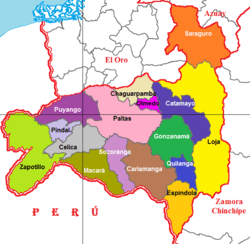
Zapotillo Canton
| Zapotillo Canton Zapotillo Hermoso, Paraiso escondido en la tierra, Centinela de la Patria | |
|---|---|
| Canton | |
 Location of Loja Province in Ecuador. | |
 Cantons of Loja Province | |
| Coordinates: EC 4°23′14″S 80°14′43″W / 4.3873°S 80.2454°W | |
| Country |
|
| Province | Loja Province |
| Area | |
| • Total | 478 sq mi (1,238 km2) |
| Elevation | 1,066 ft (325 m) |
| Time zone | ECT (UTC-5) |
Zapotillo Canton is a canton of Ecuador, located in the Loja Province. Its capital is the town of Zapotillo. Its population at the 2001 census was 10,940.[1]
General information
Header Cantonal: Zapotillo
Elevation: 325 m.s.n.m
Average temperature: 26 °C
Area: 1238 Km2
Climate: Subtropical dry
Location: Southeast of the province of Loja
Limits:
North and South: Republic of Peru
East Puyango Canton, Pinal, and Macara Celica
West. Republic of Peru
Political Division:
1 urban parish, 5 rural parishes and 69 barrios
urban parish: Zapotillo
rural parishes: Mangahurco, Garzarreal, Lemons, Paletillas, and Bolaspamba
TRADITIONAL PARTY'
- Cantonization August 27
- Religious celebration January 20
References
- ↑ Cantons of Ecuador at statoids.com
This article is issued from Wikipedia - version of the 3/30/2014. The text is available under the Creative Commons Attribution/Share Alike but additional terms may apply for the media files.