Zarakas
For the ruined monastery in Corinthia, Greece, see Zaraka Monastery.
| Zarakas Ζάρακας | |
|---|---|
 Zarakas | |
|
Location within the regional unit 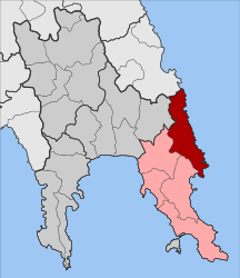 | |
| Coordinates: 36°51′N 23°00′E / 36.850°N 23.000°ECoordinates: 36°51′N 23°00′E / 36.850°N 23.000°E | |
| Country | Greece |
| Administrative region | Peloponnese |
| Regional unit | Laconia |
| Municipality | Monemvasia |
| • Municipal unit | 237.2 km2 (91.6 sq mi) |
| Population (2011)[1] | |
| • Municipal unit | 1,378 |
| • Municipal unit density | 5.8/km2 (15/sq mi) |
| Time zone | EET (UTC+2) |
| • Summer (DST) | EEST (UTC+3) |
| Vehicle registration | AK |
Zarakas (Greek: Ζάρακας) is a municipal unit[2] and a former municipality in Laconia, Peloponnese, Greece. Since the 2011 local government reform it is part of the Monemvasia municipality.[3] The municipal unit has an area of 237.226 km2.[4] Population 1,378 (2011). The seat of the municipality was in the town of Reichea. The municipal unit consits of the following local communities (consituent villages between brackets):
- Charakas
- Ierakas (Agios Ioannis, Ariana, Ierakas, Limenas Ierakos, Longari)
- Kyparissi (Kapsala, Kyparissi, Mitropoli, Paralia)
- Lampokampos (Lampokampos, Pistamata)
- Reichea (Belesaiika, Reichea)
References
- ↑ "Απογραφή Πληθυσμού - Κατοικιών 2011. ΜΟΝΙΜΟΣ Πληθυσμός" (in Greek). Hellenic Statistical Authority.
- ↑ δημοτική ενότητα - dimotiki enotita
- ↑ "Kallikratis law" (PDF) (in Greek). Greece Ministry of Interior. 11 August 2010. Archived (PDF) from the original on 15 May 2011.
- ↑ "Population & housing census 2001 (incl. area and average elevation)" (PDF) (in Greek). National Statistical Service of Greece.
This article is issued from Wikipedia - version of the 12/1/2016. The text is available under the Creative Commons Attribution/Share Alike but additional terms may apply for the media files.