Zerhoun
| Jbel Zerhoun جبل زرهون | |
|---|---|
|
View of Jbel Zerhoun | |
| Highest point | |
| Elevation | 1,025 m (3,363 ft) |
| Coordinates | 34°2′1.8″N 05°31′12.54″W / 34.033833°N 5.5201500°WCoordinates: 34°2′1.8″N 05°31′12.54″W / 34.033833°N 5.5201500°W |
| Geography | |
 Jbel Zerhoun | |
| Parent range | Rif |
| Climbing | |
| First ascent | Unknown |
| Easiest route | From Meknes |
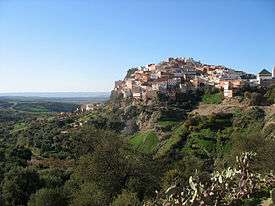
Zerhoun (Arabic: جبل زرهون also spelled Zarhun or Zarhon) is a mountain in Morocco, north of Meknes. On the hill is the Moulay Idris Zarhona town, named after Moulay Idris I, the founder of the Idrisid dynasty who was buried there in 791 AD.[1]
Geography
Since the whole town of Moulay Idris is considered a sanctuary, it pays no taxes, and provides no soldiers. Non-Muslims are allegedly forbidden within the village after dark. This is plausible, considering the lack of lodging.[2]
Near the Zerhoun range are the ruins of Volubilis, or Pharaohs Castle, once the Roman capital, and the first home of Idris I. It was settled by Phoenicians or Carthaginians prior to the conclusion of the Punic Wars, when it was annexed by Rome.[3] After the withdrawal of Rome, Christian Berbers continued to inhabit Volubilis until the seventh century AD (Bidwell, 2005). Volubilis has been designated as a World Heritage Site.
See also
References
- ↑
 This article incorporates text from a publication now in the public domain: Chisholm, Hugh, ed. (1911). "Zarhón". Encyclopædia Britannica (11th ed.). Cambridge University Press.
 - ↑ Margaret Bidwell and Robin Bidwell (2005) Morocco: The Traveller's Companion, Tauris Parke Publishing, 326 pages, ISBN 1845111079
- ↑ C. Michael Hogan (2007) Volubilis, The Megalithic Portal, edited by A. Burnham
External links
 Media related to Moulay Idriss at Wikimedia Commons
| High Atlas |
|
|---|---|
| Middle Atlas |
|
| Anti-Atlas |
|
| Saharan Atlas |
|
| Rif |
|
| Other peaks & ranges |
|