Zhaotong
| Zhaotong 昭通市 | |
|---|---|
| Prefecture-level city | |
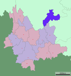 Location of Zhaotong in Yunnan | |
| Coordinates: 27°20′N 103°43′E / 27.333°N 103.717°ECoordinates: 27°20′N 103°43′E / 27.333°N 103.717°E | |
| Country | People's Republic of China |
| Province | Yunnan |
| GB/T 2260 | 530600 |
| Prefecture seat | Zhaoyang District |
| Area | |
| • Total | 23,192 km2 (8,954 sq mi) |
| Elevation | 1,926 m (6,319 ft) |
| Population | |
| • Total | 5,459,000 |
| • Density | 240/km2 (610/sq mi) |
| Time zone | China Standard (UTC+8) |
| Postal code | 657000 |
| Area code(s) | 0870 |
| License plate prefixes | 云C |
| GDP (2007) | CNY 22.54 billion |
| - per capita | CNY 4,346 |
| - per capita | CNY 4,346 |
| Yunnan e-Portal | |
| Zhaotong | |||||||||
| Chinese | 昭通 | ||||||||
|---|---|---|---|---|---|---|---|---|---|
| Postal | Chaotung | ||||||||
| |||||||||
Zhaotong (Chinese: 昭通) is a prefecture-level city located in the northeast corner of Yunnan province of Southwest China.
Demography
The prefecture, almost exclusively agricultural, is one of the poorest in China, which led the authorities to encourage young people to migrate to eastern and southern parts of China to find work. For the year 2003, the number of emigrants was 650,000.
The government wanted the number to increase by 50,000 in 2004.
Geography and climate
Influenced by the low latitude and moderate elevation, Zhaotong has a temperate subtropical highland climate (Köppen Cwb), with cool, dry winters, and warm, humid summers. Temperatures frequently drop below freezing at night in winter, though the days warm up to around 10 °C (50 °F). Conversely, in summer, average highs rise to 25 °C (77 °F). A great majority of the year's rainfall occurs from May to September.
| Climate data for Zhaotong (1971−2000) | |||||||||||||
|---|---|---|---|---|---|---|---|---|---|---|---|---|---|
| Month | Jan | Feb | Mar | Apr | May | Jun | Jul | Aug | Sep | Oct | Nov | Dec | Year |
| Record high °C (°F) | 23.6 (74.5) |
25.7 (78.3) |
28.2 (82.8) |
31.2 (88.2) |
33.4 (92.1) |
32.5 (90.5) |
31.8 (89.2) |
31.1 (88) |
29.7 (85.5) |
28.0 (82.4) |
25.1 (77.2) |
23.2 (73.8) |
33.4 (92.1) |
| Average high °C (°F) | 9.4 (48.9) |
11.8 (53.2) |
16.8 (62.2) |
20.5 (68.9) |
22.4 (72.3) |
23.4 (74.1) |
24.9 (76.8) |
24.7 (76.5) |
21.3 (70.3) |
17.4 (63.3) |
13.9 (57) |
10.6 (51.1) |
18.1 (64.6) |
| Daily mean °C (°F) | 3.7 (38.7) |
5.8 (42.4) |
10.0 (50) |
14.0 (57.2) |
16.9 (62.4) |
18.8 (65.8) |
20.3 (68.5) |
19.8 (67.6) |
16.9 (62.4) |
13.0 (55.4) |
8.9 (48) |
5.1 (41.2) |
12.8 (55) |
| Average low °C (°F) | −1.9 (28.6) |
−0.1 (31.8) |
3.3 (37.9) |
7.6 (45.7) |
11.5 (52.7) |
14.3 (57.7) |
15.7 (60.3) |
15.0 (59) |
12.5 (54.5) |
8.7 (47.7) |
3.9 (39) |
−0.4 (31.3) |
7.5 (45.5) |
| Record low °C (°F) | −9.8 (14.4) |
−10.6 (12.9) |
−6.9 (19.6) |
−2.7 (27.1) |
−0.1 (31.8) |
7.4 (45.3) |
7.5 (45.5) |
7.0 (44.6) |
4.4 (39.9) |
−0.8 (30.6) |
−5.2 (22.6) |
−10.4 (13.3) |
−10.6 (12.9) |
| Average precipitation mm (inches) | 8.6 (0.339) |
7.2 (0.283) |
13.2 (0.52) |
32.1 (1.264) |
73.7 (2.902) |
125.1 (4.925) |
158.4 (6.236) |
121.8 (4.795) |
91.2 (3.591) |
50.6 (1.992) |
18.5 (0.728) |
4.6 (0.181) |
705.0 (27.756) |
| Average precipitation days (≥ 0.1 mm) | 5.5 | 6.5 | 6.5 | 9.9 | 14.6 | 17.6 | 16.7 | 17.0 | 16.6 | 14.5 | 8.1 | 4.6 | 138.1 |
| Source: Weather China | |||||||||||||
Transport
- Zhaotong Airport (ZAT), flight destination to Kunming, Chengdu, Chongqing, Beijing, Guiyang
- Train service to Kunming, Chengdu, Guangzhou
- Zhaotong is connected to the Chongqing-Kunming National Highway network.
- China National Highway 213
- G85 Yinchuan–Kunming Expressway
Zhaotong has several bridges over the Jinsha River, an upstream section of the Yangtze.
Economy
The main industries in the prefecture are mining, tobacco and cement manufacturing
Zhaotong has some of the largest Lignite sources in China
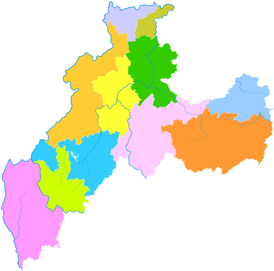
Administrative divisions
| Map | |||||
|---|---|---|---|---|---|
| Name | Hanzi | Hanyu Pinyin | Population (2003 est.) | Area (km²) | Density (/km²) |
| Zhaoyang District | 昭阳区 | Zhāoyáng Qū | 760,000 | 2,240 | 339 |
| Ludian County | 鲁甸县 | Lǔdiàn Xiàn | 370,000 | 1,519 | 244 |
| Qiaojia County | 巧家县 | Qiǎojiā Xiàn | 520,000 | 3,245 | 160 |
| Yanjin County | 盐津县 | Yánjīn Xiàn | 360,000 | 2,096 | 172 |
| Daguan County | 大关县 | Dàguān Xiàn | 250,000 | 1,802 | 139 |
| Yongshan County | 永善县 | Yǒngshàn Xiàn | 410,000 | 2,833 | 145 |
| Suijiang County | 绥江县 | Suíjiāng Xiàn | 160,000 | 882 | 181 |
| Zhenxiong County | 镇雄县 | Zhènxióng Xiàn | 1,260,000 | 3,785 | 333 |
| Yiliang County | 彝良县 | Yíliáng Xiãn | 520,000 | 2,884 | 180 |
| Weixin County | 威信县 | Wēixìn Xiàn | 370,000 | 1,416 | 261 |
| Shuifu County | 水富县 | Shuǐfù Xiàn | 90,000 | 319 | 282 |
See also
References
- Zhaotong Community Development Program - Norwegian Embassy
External links
| Wikimedia Commons has media related to Zhaotong. |
Yunnan topics | |
|---|---|
| General | |
| Geography | |
| Education | |
| Culture | |
| Cuisine |
|
| Visitor attractions | |
| |