Zlatno, Zlaté Moravce District
| Zlatno | |
| Village | |
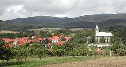 Overall view of Zlatno | |
| Country | Slovakia |
|---|---|
| Region | Nitra |
| District | Zlaté Moravce |
| Tourism region | Tekov |
| River | Stráňka |
| Elevation | 330 m (1,083 ft) |
| Coordinates | SK 48°27′46″N 18°19′00″E / 48.46278°N 18.31667°ECoordinates: SK 48°27′46″N 18°19′00″E / 48.46278°N 18.31667°E |
| Highest point | Javorový vrch |
| - elevation | 730 m (2,395 ft) |
| Area | 15.37 km2 (5.934 sq mi) |
| Population | 239 (2009-04-03) |
| Density | 16/km2 (41/sq mi) |
| Mayor | Róbert Šlehobr (SMER) |
| Postal code | 951 91 (post office Hosťovce) |
| Area code | +421-37 |
| Car plate | ZM |
  Location of Zlatno in Slovakia | |
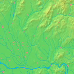  Location of Zlatno within the Nitra Region | |
| Wikimedia Commons: Zlatno, Zlaté Moravce District | |
| Statistics: | |
| Website: www.zlatno.estranky.sk | |
Zlatno (Hungarian: Kisaranyos) is a village and municipality in Zlaté Moravce District of the Nitra Region, in western-central Slovakia. Total municipality population was 223 inhabitants in 2011.
Notable personalities
- Emil Benčík, Slovak writer and journalist
- Michal Lukniš, Slovak geographer and university teacher
- Michal Zaťko, Slovak hydrographer and university teacher
External links
This article is issued from Wikipedia - version of the 7/20/2016. The text is available under the Creative Commons Attribution/Share Alike but additional terms may apply for the media files.