Đại Từ District
| Đại Từ District Huyện Đại Từ | |
|---|---|
| Rural district | |
 | |
 Đại Từ District | |
| Coordinates: VN 21°36′17″N 105°37′28″E / 21.60472°N 105.62444°E | |
| Country |
|
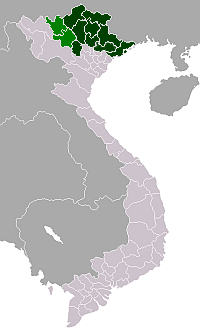
| Region | Northeast |
| Province | Thái Nguyên |
| Capital | Đại Từ |
| Area | |
| • Total | 223 sq mi (578 km2) |
| Population (2003) | |
| • Total | 163,637 |
| Time zone | UTC + 7 (UTC+7) |
Đại Từ is a rural district of Thái Nguyên Province in the Northeast region of Vietnam. As of 2003 the district had a population of 163,637 .[1] The district covers an area of 578 km². The district capital lies at Đại Từ.[1]
Administrative divisions
Đại Từ, Quân Chu, An Khánh, Bản Ngoại, Bình Thuận, Cát Nê, Cù Vân, Đức Lương, Hà Thượng, Hoàng Nông, Hùng Sơn, Khôi Kỳ, Ký Phú, La Bằng, Lục Ba, Minh Tiến, Mỹ Yên, Na Mao, Phú Cường, Phú Lạc, Phú Thịnh, Phú Xuyên, Phúc Lương, Phục Linh, Quân Chu, Tân Linh, Tân Thái, Tiên Hội, Vạn Thọ, Văn Yên, Yên Lãng
References
- 1 2 "Districts of Vietnam". Statoids. Retrieved March 23, 2009.

Coordinates: 21°38.52′N 105°38.23′E / 21.64200°N 105.63717°E
This article is issued from Wikipedia - version of the 9/24/2016. The text is available under the Creative Commons Attribution/Share Alike but additional terms may apply for the media files.