1908 Atlantic hurricane season
| |
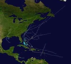
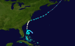
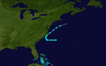
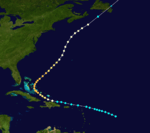
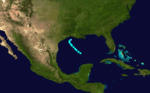
| Season summary map |
| First system formed |
March 6, 1908 |
| Last system dissipated |
October 23, 1908 |
| Strongest storm1 |
Six – 120 mph (195 km/h) |
| Total depressions |
13 |
| Total storms |
10 |
| Hurricanes |
6 |
| Major hurricanes (Cat. 3+) |
1 |
| Total fatalities |
Unknown |
| Total damage |
Unknown |
| 1Strongest storm is determined by lowest pressure |
Atlantic hurricane seasons
1906, 1907, 1908, 1909, 1910 |
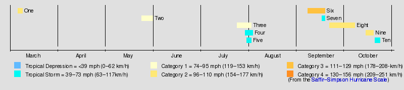
The 1908 Atlantic hurricane season ran from June 1 to November 30 in 1908. These dates conventionally delimit the year in which most tropical cyclones form in the Atlantic basin. However, this season got off to a very early start, with a Category 2 hurricane forming on March 6, making it the third earliest hurricane on record to form in the Atlantic Basin after Hurricane One in 1938 and Hurricane Alex in 2016, and the only known Atlantic tropical cyclone to exist in the month of March. Another hurricane formed and existed during the last week of May, and became the earliest hurricane to hit the U.S. in recorded history. Cape Hatteras was affected by two hurricanes and one tropical storm this year. Overall, this season was near average with 10 tropical storms forming.
Storms
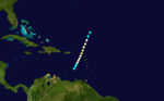
Hurricane One
| Category 2 hurricane (SSHWS) |
|
|
| Duration |
March 6 – March 9 |
| Peak intensity |
100 mph (155 km/h) (1-min) <991 mbar (hPa) |
The season's first tropical cyclone was initially observed by a ship at 12:00 UTC on March 6 while located about 430 mi (690 km) northeast of Barbuda.[1][2] Tracking in an unusual south-southwest direction, the storm intensified into a Category 1 hurricane on the modern day Saffir–Simpson hurricane wind scale. Shortly before reaching the United States Virgin Islands early on March 8, the hurricane intensified into a Category 2 hurricane,[1] peaking with maximum sustained winds of 100 mph (155 km/h) and a minimum barometric pressure of 991 mbar (29.3 inHg), which was observed in Basseterre, Saint Kitts and Nevis.[2] Once in the Caribbean Sea on March 8, the system slowly began to weaken, losing hurricane status the following morning. The storm was last noted about 130 mi (210 km) north of Blanquilla Island late on March 9.[1]
On Saint Barthélemy, some buildings were damaged. Winds in Saint Martin toppled pheasant tents and damaged crops. The city of Basseterre on Saint Kitts reported winds at 50 mph (80 km/h) and rainfall reaching 8 in (200 mm).[3] The storm beached 24 small crafts and boats and severely damaged crops.[2]
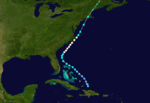
Hurricane Two
| Category 1 hurricane (SSHWS) |
|
|
| Duration |
May 24 – May 31 |
| Peak intensity |
75 mph (120 km/h) (1-min) 989 mbar (hPa) |
A tropical depression developed on May 24 at 12:00 UTC about 50 mi (80 km) southwest of Cockburn Town, Turks and Caicos Islands. Moving northwestward, the depression struck the Turks and Caicos Islands. Around 06:00 UTC on May 26, the depression intensified into a tropical storm. By late on May 27, the storm curved northeastward. The cyclone strengthened into a hurricane by 06:00 UTC the following day. It made landfall west of Cape Hatteras, North Carolina, with winds of 75 mph (120 km/h) around 21:00 UTC on May 29.[1] A barometric pressure of 989 mbar (29.2 inHg) was observed at Hatteras, the lowest in relation to the storm.[2] A few hours later, the cyclone reemerged into the Atlantic Ocean. Early on May 30, the hurricane weakened to a tropical storm. Accelerating northeastward, the storm struck eastern Long Island, New York, with winds of 40 mph (65 km/h) late on May 30, just prior to making landfall near Noank, Connecticut, at the same intensity around 23:00 UTC. The storm became extratropical over southern Maine early on May 31. The remnants continued northeastward until dissipating over the northern portion of the state several hours later.[1]
This hurricane hit the U.S. in May, causing minor effects. It was one of only three May hurricanes during the 20th century in the Atlantic Basin; the others were Able in 1951 and Alma in 1970. It marked the earliest date for the season's second hurricane to form in any Atlantic season on record, and it was the earliest hurricane to hit the U.S. in recorded history.
Hurricane Three
| Category 1 hurricane (SSHWS) |
|
|
| Duration |
July 24 – August 2 |
| Peak intensity |
80 mph (130 km/h) (1-min) 985 mbar (hPa) |
This storm formed north of the Bahamas on July 24. The storm then made a loop north of the Bahamas and became a hurricane shortly after. The storm grazed North Carolina and moved into the Atlantic. The storm dissipated on August 3.
Tropical Storm Four
| Tropical storm (SSHWS) |
|
|
| Duration |
July 29 – August 3 |
| Peak intensity |
60 mph (95 km/h) (1-min) |
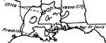
A tropical depression developed just offshore Sabine Pass, Texas, around 00:00 UTC on July 29. Moving southeastward, the depression intensified into a tropical storm about 12 hours later. Early on July 30, the storm peaked with maximum sustained winds of 60 mph (95 km/h). Eventually, it recurved to the north-northwest and headed toward Louisiana. At 22:00 UTC on July 31, the cyclone made landfall on Marsh Island, Louisiana, at the same intensity. The storm weakened to a tropical depression early on August 2, around the time it curved northeastward. By late on August 3, the system dissipated over northern Mississippi.[1]
It turned around and made landfall in Louisiana, dropping 19.62 inches (498 mm) at Franklin, Louisiana between July 26 and August 2.[4]
Tropical Storm Five
| Tropical storm (SSHWS) |
|
|
| Duration |
August 30 – September 2 |
| Peak intensity |
50 mph (85 km/h) (1-min) |
A ship detected a tropical storm about 230 mi (370 km) southeast of Cape Hatteras, North Carolina, at 12:00 UTC on August 30.[1][2] The storm moved westward, until turning northeastward late on August 31. At 00:00 UTC on September 1, the system peaked with maximum sustained winds of 50 mph (85 km/h). Eight hours later, it made landfall near Cape Lookout, North Carolina, at the same intensity. Shortly thereafter, the storm reemerged into the Atlantic Ocean. The system transitioned into an extratropical cyclone at 18:00 UTC on September 2, while located about 135 mi (215 km) southeast of Nantucket, Massachusetts.[1] The storm brought strong winds to portions of North Carolina and Virginia.[2]
Hurricane Six
| Category 3 hurricane (SSHWS) |
|
|
| Duration |
September 7 – September 18 |
| Peak intensity |
120 mph (195 km/h) (1-min) |
The sixth and strongest storm of the season was a Category 3 in mid-September that moved across the central Bahamas and turned out to sea.
Tropical Storm Seven
| Tropical storm (SSHWS) |
|
|
| Duration |
September 16 – September 18 |
| Peak intensity |
70 mph (110 km/h) (1-min) |
A ship first observed this tropical storm about 245 mi (395 km) north-northwest of Telchac Puerto, Yucatán, at 12:00 UTC on September 16.[1][5] The storm intensified gradually while moving northwestward, peaking with maximum sustained winds of 70 mph (110 km/h) at 00:00 UTC on September 18. However, the cyclone soon quickly weakened, falling to tropical depression intensity about 18 hours later. It then dissipated about 70 mi (115 km) south-southwest of the Texas–Louisiana state line.[1]
Hurricane Eight
| Category 2 hurricane (SSHWS) |
|
|
| Duration |
September 21 – October 7 |
| Peak intensity |
110 mph (175 km/h) (1-min) <971 mbar (hPa) |
1908's eighth storm was a Category 2 hurricane in late September and early October that crossed the Lesser Antilles, moved over Hispaniola and eastern Cuba, and crossed over the Bahamas before turning northeast. It then made a loop and became extratropical on October 7. It caused extensive damage to the Greater Antilles.
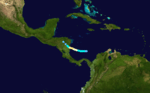
Hurricane Nine
| Category 2 hurricane (SSHWS) |
|
|
| Duration |
October 14 – October 19 |
| Peak intensity |
105 mph (165 km/h) (1-min) |
A ship indicated that a tropical depression developed about 160 mi (255 km) north-northeast of Nombre de Dios, Colón, on October 14 at 12:00 UTC.[1][5] Moving westward, the depression became a tropical storm early the following day.[1] The storm later curved to the west-northwest and intensified into a Category 1 hurricane around 12:00 UTC on October 16. About 24 hours later, it became a Category 2 hurricane. Late on October 17, the hurricane peaked with maximum sustained winds of 105 mph (165 km/h). Early the next day, it made landfall near the North Caribbean Coast Autonomous Region–South Caribbean Coast Autonomous Region line in Nicaragua at the same intensity.[1]
In mid-October, the ninth storm of the season, a Category 2 hurricane, struck Nicaragua. Because it moved slowly, very heavy rainfall fell in its path, although there is no known damage or deaths from the hurricane itself.
Tropical Storm Ten
| Tropical storm (SSHWS) |
|
|
| Duration |
October 20 – October 23 |
| Peak intensity |
40 mph (65 km/h) (1-min) |
This storm formed off of the Carolinas on October 19. It stayed out in the Atlantic until it transitioned into an extratropical cyclone and made landfall in South Carolina shortly before dissipating.
See also
References
- 1 2 3 4 5 6 7 8 9 10 11 12 13 National Hurricane Center; Hurricane Research Division (July 6, 2016). "Atlantic hurricane best track (HURDAT version 2)". United States National Oceanic and Atmospheric Administration. Retrieved December 5, 2016.
- 1 2 3 4 5 6 Jose Fernandez Partagas & Henry F. Diaz (1997). Year 1908 (PDF). Atlantic Oceanographic and Meteorological Laboratory (Report). Miami, Florida: National Oceanic and Atmospheric Administration. Retrieved June 9, 2016.
- ↑ John T. Quin (May 20, 1908). A Hurricane in the West Indies in March, 1908 (PDF). Atlantic Oceanographic and Meteorological Laboratory (Report). St. Croix: National Oceanic and Atmospheric Administration.
- ↑ United States Corp of Engineers (1945). Storm Total Rainfall In The United States. War Department. p. LMV 3–14.
- 1 2 Jose Fernandez Partagas & Henry F. Diaz (1997). Year 1908 (PDF). Atlantic Oceanographic and Meteorological Laboratory (Report). Miami, Florida: National Oceanic and Atmospheric Administration. Retrieved June 9, 2016.
External links