1974 Pacific typhoon season
| |
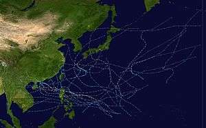
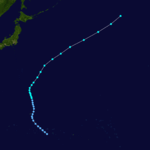
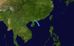
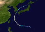
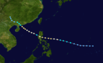
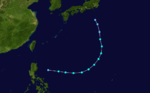
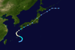
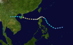
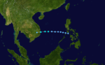
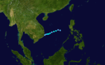
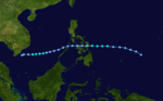
| Season summary map |
| First system formed |
January 9, 1974 |
| Last system dissipated |
December 24, 1974 |
| Strongest storm1 |
Gloria – 930 hPa (mbar), 220 km/h (140 mph) (1-minute sustained) |
| Total depressions |
35 |
| Total storms |
32 |
| Typhoons |
16 |
| Super typhoons |
0 (record low) |
| Total fatalities |
Unknown |
| Total damage |
Unknown |
| 1Strongest storm is determined by lowest pressure |
Pacific typhoon seasons
1972, 1973, 1974, 1975, 1976 |
The 1974 Pacific typhoon season has no official bounds; it ran year-round in 1974, but most tropical cyclones tend to form in the northwestern Pacific Ocean between June and December. These dates conventionally delimit the period of each year when most tropical cyclones form in the northwestern Pacific Ocean.
The scope of this article is limited to the Pacific Ocean, north of the equator and west of the international date line. Storms that form east of the date line and north of the equator are called hurricanes; see 1974 Pacific hurricane season. Tropical Storms formed in the entire west pacific basin were assigned a name by the Joint Typhoon Warning Center. Tropical depressions in this basin have the "W" suffix added to their number. Tropical depressions that enter or form in the Philippine area of responsibility are assigned a name by the Philippine Atmospheric, Geophysical and Astronomical Services Administration or PAGASA. This can often result in the same storm having two names.
Storms
35 tropical depressions formed this year in the Western Pacific, of which 32 became tropical storms. 16 storms reached typhoon intensity, and none reached super typhoon strength.[1] This season is the most recent to have no super typhoons.[2]
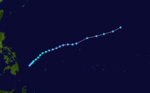
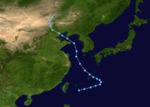
Tropical Storm Wanda (Atang)
| Tropical storm (SSHWS) |
|
|
| Duration |
January 9 – January 14 |
| Peak intensity |
100 km/h (65 mph) (1-min) 992 hPa (mbar) |
Tropical Storm Amy
| Tropical storm (SSHWS) |
|
|
| Duration |
March 13 – March 21 |
| Peak intensity |
100 km/h (65 mph) (1-min) 992 hPa (mbar) |
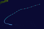
Tropical Storm Babe
| Tropical storm (SSHWS) |
|
|
| Duration |
April 25 – May 3 |
| Peak intensity |
110 km/h (70 mph) (1-min) 985 hPa (mbar) |
Typhoon Carla
| Category 1 typhoon (SSHWS) |
|
|
| Duration |
May 1 – May 8 |
| Peak intensity |
150 km/h (90 mph) (1-min) 965 hPa (mbar) |
Tropical Depression 05W
| Tropical depression (SSHWS) |
|
|
| Duration |
June 6 – June 8 |
| Peak intensity |
55 km/h (35 mph) (1-min) |
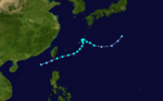
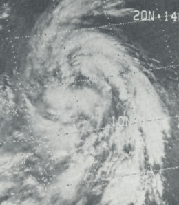
Typhoon Dinah (Bising)
| Category 1 typhoon (SSHWS) |
|
|
| Duration |
June 7 – June 14 |
| Peak intensity |
130 km/h (80 mph) (1-min) 965 hPa (mbar) |
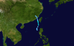
Dinah, which developed on June 7, hit Luzon on the 10th as an 80 mph typhoon. It continued northwestward, hit Hainan Island, crossed the Gulf of Tonkin, and dissipated over Vietnam. Dinah caused 73 casualties (with 33 missing), with $3 million in crop damage (1974 USD).
Tropical Storm Emma (Klaring)
| Tropical storm (SSHWS) |
|
|
| Duration |
June 12 – June 19 |
| Peak intensity |
110 km/h (70 mph) (1-min) 990 hPa (mbar) |
Tropical Storm Freda
| Tropical storm (SSHWS) |
|
|
| Duration |
June 20 – June 23 |
| Peak intensity |
85 km/h (50 mph) (1-min) 990 hPa (mbar) |
Typhoon Gilda (Deling)
| Category 2 typhoon (SSHWS) |
|
|
| Duration |
June 29 – July 8 |
| Peak intensity |
165 km/h (105 mph) (1-min) 945 hPa (mbar) |
When Tropical Storm Gilda, having weakened from a peak of 100 mph winds, crossed between Japan and South Korea in early July, it brought torrential rains and mudslides, killing 128 people (with 26 missing) and causing damage estimated at $1.5 billion (1974 USD).
Tropical Storm Harriet (Gading)
| Tropical storm (SSHWS) |
|
|
| Duration |
July 14 – July 20 |
| Peak intensity |
85 km/h (50 mph) (1-min) 995 hPa (mbar) |
Tropical Storm Jean (Heling)
| Tropical storm (SSHWS) |
|
|
| Duration |
July 16 – July 21 |
| Peak intensity |
85 km/h (50 mph) (1-min) 995 hPa (mbar) |
Typhoon Ivy (Iliang)
| Category 2 typhoon (SSHWS) |
|
|
| Duration |
July 16 – July 24 |
| Peak intensity |
175 km/h (110 mph) (1-min) 950 hPa (mbar) |
66 people were killed with Typhoon Ivy hit Luzon on July 20. It continued northwestward, and hit southeastern China 2 days later.
Typhoon Kim
| Category 1 typhoon (SSHWS) |
|
|
| Duration |
July 22 – July 28 |
| Peak intensity |
120 km/h (75 mph) (1-min) 990 hPa (mbar) |
Tropical Storm Lucy (Miding)
| Tropical storm (SSHWS) |
|
|
| Duration |
August 8 – August 12 |
| Peak intensity |
65 km/h (40 mph) (1-min) 995 hPa (mbar) |
Typhoon Mary
| Category 1 typhoon (SSHWS) |
|
|
| Duration |
August 10 – August 26 |
| Peak intensity |
130 km/h (80 mph) (1-min) 965 hPa (mbar) |
The monsoon trough spawned a tropical depression on August 10. It tracked to the northeast, then turned to the northwest where it became a tropical storm on the 11th. Mary's appearance resembled an extratropical cyclone due to vertical shear, and as the ridge built over Japan, Mary turned more to the west. Conditions were favorable enough for Mary to reach typhoon strength on the 18th, but it weakened to a tropical storm before hitting northeastern China on the 19th. A high pressure system over China forced now Tropical Depression Mary to the southeast, where it restrengthened into a tropical storm on the 24th. The storm turned to the northeast, briefly becoming a typhoon again on the 25th before weakening. Mary hit Japan on the 26th, and dissipated shortly thereafter. 3 lives were lost in Mary's path, with moderate damage occurring.
Tropical Depression 16W
| Tropical depression (SSHWS) |
|
|
| Duration |
August 13 – August 15 |
| Peak intensity |
55 km/h (35 mph) (1-min) 995 hPa (mbar) |
Tropical Storm Nadine (Norming)
| Tropical storm (SSHWS) |
|
|
| Duration |
August 15 – August 18 |
| Peak intensity |
95 km/h (60 mph) (1-min) 980 hPa (mbar) |
Typhoon Polly
| Category 2 typhoon (SSHWS) |
|
|
| Duration |
August 24 – September 8 |
| Peak intensity |
175 km/h (110 mph) (1-min) 950 hPa (mbar) |
Tropical Depression 20W
| Tropical depression (SSHWS) |
|
|
| Duration |
August 26 – August 31 |
| Peak intensity |
55 km/h (35 mph) (1-min) 995 hPa (mbar) |
Tropical Storm Rose (Oyang)
| Tropical storm (SSHWS) |
|
|
| Duration |
August 27 – September 1 |
| Peak intensity |
95 km/h (60 mph) (1-min) 985 hPa (mbar) |
Typhoon Shirley (Pasing)
| Category 1 typhoon (SSHWS) |
|
|
| Duration |
September 3 – September 11 |
| Peak intensity |
140 km/h (85 mph) (1-min) 970 hPa (mbar) |
Tropical Storm Trix
| Tropical storm (SSHWS) |
|
|
| Duration |
September 4 – September 8 |
| Peak intensity |
75 km/h (45 mph) (1-min) 990 hPa (mbar) |
Typhoon Virginia
| Category 1 typhoon (SSHWS) |
|
|
| Duration |
September 11 – September 17 |
| Peak intensity |
140 km/h (85 mph) (1-min) 970 hPa (mbar) |
Tropical Storm Wendy (Ruping)
| Tropical storm (SSHWS) |
|
|
| Duration |
September 23 – September 30 |
| Peak intensity |
110 km/h (70 mph) (1-min) 985 hPa (mbar) |
Typhoon Agnes
| Category 3 typhoon (SSHWS) |
|
|
| Duration |
September 24 – October 2 |
| Peak intensity |
195 km/h (120 mph) (1-min) 960 hPa (mbar) |
Typhoon Bess (Susang)
| Category 1 typhoon (SSHWS) |
|
|
| Duration |
October 8 – October 14 |
| Peak intensity |
120 km/h (75 mph) (1-min) 975 hPa (mbar) |
Typhoon Bess crossed northern Luzon on October 10, crossed the South China Sea, and hit Hainan Island on the 13th. Bess continued westward, and dissipated over Vietnam on the 14th. The storm dumped heavy rains on its path, causing 26 deaths (with 3 missing) and $9.2 million (1974 USD) in damage. The name Bess was retired after this season.
Typhoon Carmen (Tering)
| Category 1 typhoon (SSHWS) |
|
|
| Duration |
October 13 – October 20 |
| Peak intensity |
140 km/h (85 mph) (1-min) 975 hPa (mbar) |
Typhoon Carmen hit Luzon on October 16, just days after Bess hit. It continued northwestward, made landfall on southeastern China, turned south, and dissipated on the 20th. Typhoon Carmen caused sustained storm force winds in Hong Kong and 25 fatalities, with damage estimated at $13 million (1974 USD).
Typhoon Della (Uding)
| Category 2 typhoon (SSHWS) |
|
|
| Duration |
October 20 – October 27 |
| Peak intensity |
165 km/h (105 mph) (1-min) 960 hPa (mbar) |
Typhoon Elaine (Wening)
| Category 2 typhoon (SSHWS) |
|
|
| Duration |
October 23 – November 1 |
| Peak intensity |
175 km/h (110 mph) (1-min) 940 hPa (mbar) |
23 casualties and $21 million in damage can be attributed to 110 mph Typhoon Elaine hitting northern Luzon on October 27.
Tropical Storm Faye (Yaning)
| Tropical storm (SSHWS) |
|
|
| Duration |
October 31 – November 5 |
| Peak intensity |
100 km/h (65 mph) (1-min) 985 hPa (mbar) |
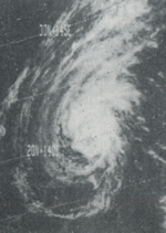
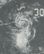
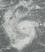
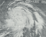
Typhoon Gloria (Aning)
| Category 4 typhoon (SSHWS) |
|
|
| Duration |
November 2 – November 10 |
| Peak intensity |
220 km/h (140 mph) (1-min) 930 hPa (mbar) |
Tropical Storm Hester
| Tropical storm (SSHWS) |
|
|
| Duration |
November 13 – November 15 |
| Peak intensity |
65 km/h (40 mph) (1-min) 1000 hPa (mbar) |
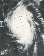
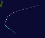
Typhoon Irma (Bidang)
| Category 4 typhoon (SSHWS) |
|
|
| Duration |
November 20 – December 3 |
| Peak intensity |
215 km/h (130 mph) (1-min) 940 hPa (mbar) |
The last of the year's 8 typhoons to hit the Philippines made landfall on November 28 as a 100 mph typhoon. Irma, once a 135 mph typhoon, weakened over the islands and restrengthened into a typhoon in the South China Sea. It turned northward, and hit southern China as a weakening tropical storm on December 2, the latest date for a Chinese tropical storm landfall. Irma killed 11 people, and caused $7.3 million in damage (1974 USD).
Tropical Storm Judy
| Tropical storm (SSHWS) |
|
|
| Duration |
December 17 – December 19 |
| Peak intensity |
75 km/h (45 mph) (1-min) 1000 hPa (mbar) |
Tropical Storm Kit (Delang)
| Tropical storm (SSHWS) |
|
|
| Duration |
December 18 – December 24 |
| Peak intensity |
75 km/h (45 mph) (1-min) 995 hPa (mbar) |
See also
References
- ↑ "Annual Typhoon Report 1974" (PDF). Joint Typhoon Warning Center. Retrieved 2012-10-30.
- ↑ "Annual Tropical Cyclone Report 2011" (PDF). Joint Typhoon Warning Center. p. 14. Retrieved 2012-10-30.
External links