1974 Atlantic hurricane season
| |
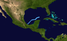
| Season summary map |
| First system formed |
June 22, 1974 |
| Last system dissipated |
November 12, 1974 |
| Strongest storm1 |
Carmen – 928 mbar (hPa) (27.4 inHg), 150 mph (240 km/h) (1-minute sustained) |
| Total depressions |
21 |
| Total storms |
11 |
| Hurricanes |
4 |
| Major hurricanes (Cat. 3+) |
2 |
| Total fatalities |
≥8,270 |
| Total damage |
$2 billion (1974 USD) |
| 1Strongest storm is determined by lowest pressure |
Atlantic hurricane seasons
1972, 1973, 1974, 1975, 1976 |
| Related article |
|
|
The 1974 Atlantic hurricane season officially began on June 1, 1974, and lasted until November 30, 1974. These dates conventionally delimit the period of each year when most tropical cyclones form in the Atlantic basin. The season had near average activity, with eleven total storms and four hurricanes forming.
The most notable storms of the season were Hurricane Carmen, which made landfall on the Yucatán Peninsula and in Louisiana, causing at least $150 million (1974 US dollars) in damages; and Hurricane Fifi, which killed 8,000 people as it skimmed along the northern coast of Honduras. Hurricane Fifi crossed over into the eastern Pacific and was renamed Orlene.
Storms
The season's activity was reflected with a cumulative accumulated cyclone energy (ACE) rating of 61.[1] ACE is, broadly speaking, a measure of the power of the hurricane multiplied by the length of time it existed, so storms that last a long time, as well as particularly strong hurricanes, have high ACEs. ACE is only calculated for full advisories on tropical systems at or exceeding 34 knots (39 mph, 63 km/h) or tropical storm strength.[2]
Tropical Depression One
| Tropical depression (SSHWS) |
|
|
| Duration |
June 22 – June 26 |
| Peak intensity |
30 mph (45 km/h) (1-min) 995 mbar (hPa) |
On June 22, a tropical depression formed. The depression eventually became Subtropical Storm One on June 24. It remained weak and dissipated on June 26.
Subtropical Storm One
| Subtropical storm (SSHWS) |
|
|
| Duration |
June 22 – June 25 |
| Peak intensity |
65 mph (100 km/h) (1-min) 1000 mbar (hPa) |
A tropical depression formed over the southwestern Gulf of Mexico on June 22. It was classified as Tropical Depression One. As the depression moved southwestward, convection began to fire well northeast of the center forming a new cyclone by June 24. Convection over the new system was poorly organized, and it became a subtropical depression late on June 24. It strengthened into a subtropical storm on June 25 with its winds far away from the center. It crossed Florida that day, but that night, it became more frontal in character. It lost what tropical characteristics it had on June 25.
Subtropical Storm One caused three drowning deaths and $10 million in damage ($42 million in 2005 USD) when it passed over central Florida. Tropical Depression One and Subtropical Storm One are actually the same storm, but JTWC classified them as 2 separate systems.
Tropical Depression Two
| Tropical depression (SSHWS) |
|
|
| Duration |
July 13 – July 17 |
| Peak intensity |
35 mph (55 km/h) (1-min) 1011 mbar (hPa) |
On July 13, a tropical depression formed. It remained weak and dissipated on July 17.
Subtropical Storm Two
| Subtropical storm (SSHWS) |
|
|
| Duration |
July 16 – July 19 |
| Peak intensity |
50 mph (85 km/h) (1-min) 1006 mbar (hPa) |
A convective area of cloudiness existed northeast of the Bahamas in mid July in response to a stationary frontal boundary. A subtropical depression formed on July 16, and it became Subtropical Storm Two on July 17. As it moved northeastward it gradually became absorbed by a large extratropical low pressure system, with the system dissipating on July 20.
Tropical Depression Three
| Tropical depression (SSHWS) |
|
|
| Duration |
July 31 – August 2 |
| Peak intensity |
35 mph (55 km/h) (1-min) 1008 mbar (hPa) |
On July 31, a tropical depression formed. It remained weak and dissipated on August 2.
Subtropical Storm Three
| Subtropical storm (SSHWS) |
|
|
| Duration |
August 10 – August 15 |
| Peak intensity |
60 mph (95 km/h) (1-min) 992 mbar (hPa) |
Subtropical Storm Three formed from a frontal wave on August 10, located 300 mi (480 km) south of Cape Cod. The storm moved southeastward, followed by a north, then northeast motion. The storm reached its peak of 60 mph (97 km/h) late in its life, just prior to being absorbed by a frontal boundary on August 15.
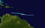
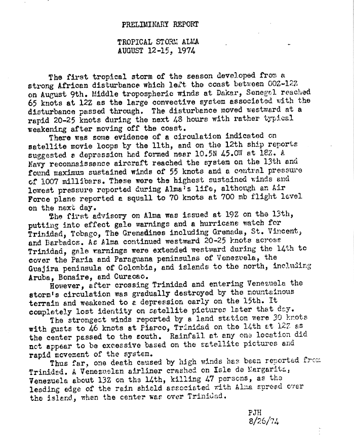
Tropical Storm Alma
| Tropical storm (SSHWS) |
|
|
| Duration |
August 12 – August 15 |
| Peak intensity |
65 mph (100 km/h) (1-min) 1007 mbar (hPa) |
A vigorous tropical wave emerged off the western coast of Africa on August 9,[3] developing into a tropical depression by 12:00 UTC on August 12 while located about 545 miles (875 km) east-southeast of Barbados. Steered rapidly west by an abnormally strong subtropical ridge, the depression intensified into Tropical Storm Alma by 12:00 UTC the next day and attained peak winds of 65 mph (100 km/h) six hours later in accordance with data from a reconnaissance aircraft. Early on August 14, Alma made landfall in Trinidad as a minimal tropical storm, becoming the southernmost-landfalling system on the island in 41 years. The system's circulation entered Venezuela and interacted with mountainous terrain, where it dissipated by 12:00 UTC on August 15.[4][5]
Alma was responsible for two fatalities on Trinidad as well the crash of a passenger aircraft on Isla de Margarita, off the coast of Venezuela, that killed 47 people.
Tropical Depression Five
| Tropical depression (SSHWS) |
|
|
| Duration |
August 24 – August 26 |
| Peak intensity |
35 mph (55 km/h) (1-min) 1006 mbar (hPa) |
On August 24, a tropical depression formed. It remained weak and dissipated on August 26.
A sprawling system, the depression brought light to moderate rainfall to much of Texas leading to minor flooding. In Wink, more than 1.5 in (38 mm) fell in six hours.[6]
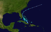
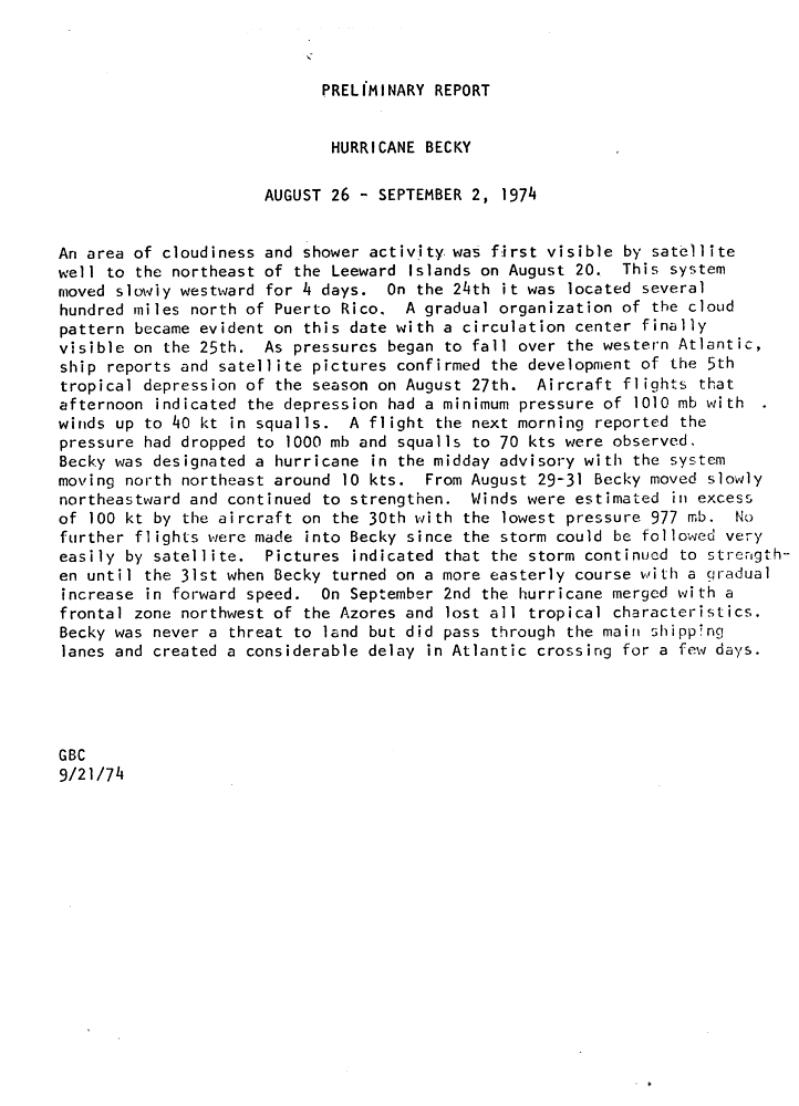
Hurricane Becky
| Category 3 hurricane (SSHWS) |
|
|
| Duration |
August 26 – September 2 |
| Peak intensity |
115 mph (185 km/h) (1-min) 977 mbar (hPa) |
The NHC first began monitoring an area of shower and thunderstorm activity northeast of the Leeward Islands on August 20.[7] The disturbance tracked northwest, and both ships observations and satellite imagery indicated the formation of a tropical depression by 12:00 UTC on August 26; at the time, it was centered about 440 miles (710 km) south-southwest of Bermuda. Following designation, the depression curved north and then northeast as it rounded the western periphery of a ridge near the Azores. A light shear environment allowed it to intensify into Tropical Storm Becky by 06:00 UTC on August 28 and further into a hurricane by 18:00 UTC that day. After attaining peaks winds of 115 mph (185 km/h) on August 30 as confirmed by a reconnaissance aircraft, Becky accelerated eastward and merged with a frontal zone northeast of the Azores early on September 2.[5]
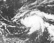
Hurricane Carmen
| Category 4 hurricane (SSHWS) |
|
|
| Duration |
August 29 – September 10 |
| Peak intensity |
150 mph (240 km/h) (1-min) 928 mbar (hPa) |
A tropical wave crossed the western coast of Africa on August 23, organizing into a tropical depression by 06:00 UTC on August 29 about 365 miles (585 km) east of Guadeloupe. The newly-designated cyclone was slow to intensify initially, with limited inflow and a majority of its circulation over the Greater Antilles. It strengthened into Tropical Storm Carmen early on August 30 and further into a hurricane by 12:00 UTC on August 31. Upon entering the western Caribbean Sea and amid a low wind shear environment, Carmen began a period of rapid intensification and attained peak winds of 150 mph (240 km/h) before moving ashore a few miles north of Chetumal, Quintana Roo.[4][5]
Carmen weakened significantly over the Yucatán Peninsula, falling to tropical storm intensity by 00:00 UTC on September 3. It emerged into the Bay of Campeche late that day and almost immediately executed a turn toward the north in response to falling pressures over the Southern United States. The cyclone steadily re-intensified over the Gulf of Mexico, and a reconnaissance aircraft into the storm around 00:00 UTC on September 8 found that maximum winds had again increased to 150 mph (240 km/h). As Carmen approaching the coastline of Louisiana, radar indicated the presence of drier air entering the eastern semicircle of the circulation, and the cyclone moved ashore south of Morgan City with winds of 120 mph (195 km/h). It turned northwest and then west-northwest after landfall and was last monitored as a tropical depression southeast of Waco, Texas at 06:00 UTC on September 10.[4][5]
Tropical Depression Eight
| Tropical depression (SSHWS) |
|
|
| Duration |
September 2 – September 11 |
| Peak intensity |
35 mph (55 km/h) (1-min) 1012 mbar (hPa) |
On September 2, a tropical depression formed. It was long lasting and dissipated on September 11.
Tropical Storm Dolly
| Tropical storm (SSHWS) |
|
|
| Duration |
September 2 – September 5 |
| Peak intensity |
50 mph (85 km/h) (1-min) 1000 mbar (hPa) |
An area of shower and thunderstorm activity became concentrated underneath an upper-level low in the west Atlantic on August 30. The disturbance drifted west-northwest while steadily organizing, and a ship report around 18:00 UTC on September 2 indicated the formation of a tropical depression about 395 miles (635 km) south-southwest of Bermuda. Although the cyclone was embedded within a high wind shear environment, a reconnaissance mission into the storm the next afternoon found that it had intensified into Tropical Storm Dolly and attained its peak winds of 50 mph (85 km/h). The storm recurved northeast ahead of an approaching trough and transitioned into an extratropical cyclone by 12:00 UTC on September 5 offshore the coastline of Nova Scotia.[4][5]
Tropical Storm Elaine
| Tropical storm (SSHWS) |
|
|
| Duration |
September 4 – September 13 |
| Peak intensity |
70 mph (110 km/h) (1-min) 1001 mbar (hPa) |
A tropical wave moved off the western coast of Africa on August 30 and acquired sufficient organization to be declared a tropical depression by 18:00 UTC on September 4 roughly 715 miles (1,150 km) east of Guadeloupe. The newly-formed cyclone moved northwest for several days, maintaining its status as a tropical depression despite the absence of a closed low-level circulation in several reconnaissance missions.[8] It eventually intensified into Tropical Storm Elaine east of North Carolina by 18:00 UTC on September 9, and with the aid of light upper-level winds, reached peak winds of 70 mph (110 km/h) early the next morning. Steered northeast by an approaching trough, Elaine interacted with a cold front and transitioned into an extratropical cyclone by 00:00 UTC on September 14 over the northern Atlantic.[4][5]
Hurricane Fifi
| Category 2 hurricane (SSHWS) |
|
|
| Duration |
September 14 – September 22 |
| Peak intensity |
110 mph (175 km/h) (1-min) 970 mbar (hPa) |
On September 8, a well-defined tropical wave emerged off the west coast of Africa into the Atlantic Ocean. Over the following five days, no development took place and the wave later entered the Caribbean on September 13.[9] The following day, the system developed into a tropical depression as it steadily tracked west-northwestward.[10] On September 16, the depression intensified into Tropical Storm Fifi just off the coast of Jamaica. The storm quickly intensified into a hurricane the following afternoon and attained its peak intensity on September 18 as a strong Category 2 hurricane. Maintaining hurricane intensity, Fifi brushed the northern coast of Honduras before making landfall in Belize the following day. The storm quickly weakened after landfall, becoming a depression late on September 20. Continuing westward, the former hurricane began to interact with another system in the eastern Pacific.[9]
Early on September 22, Fifi re-attained tropical storm status before fully regenerating into a new tropical cyclone, Tropical Storm Orlene.[11] Orlene traveled in an arcuate path toward Mexico while quickly intensifying into a Category 2 hurricane before landfall. The storm weakened after landfall and dissipated fully during the afternoon of September 24 over the mountains of Mexico.[5][9] Along its path, Fifi impacted nine countries, leaving over 8,000 fatalities and $1.8 billion in damage.[12][13] Most of the loss of life and damage occurred in Honduras where extreme rainfall from the hurricane triggered widespread flash flooding and mudslides.[14]
Tropical Depression Twelve
| Tropical depression (SSHWS) |
|
|
| Duration |
September 18 – September 20 |
| Peak intensity |
30 mph (45 km/h) (1-min) 1013 mbar (hPa) |
Formed September 18 and dissipated September 20.
Tropical Depression Thirteen
| Tropical depression (SSHWS) |
|
|
| Duration |
September 23 – September 27 |
| Peak intensity |
35 mph (55 km/h) (1-min) 1005 mbar (hPa) |
Formed September 23 and dissipated September 27.
Hurricane Gertrude
| Category 1 hurricane (SSHWS) |
|
|
| Duration |
September 27 – October 4 |
| Peak intensity |
75 mph (120 km/h) (1-min) 999 mbar (hPa) |
A disturbance developed within the Intertropical Convergence Zone just off the western coast of Africa on September 22. The system moved west-northwest and steadily coalesced, organizing into a tropical depression by 12:00 UTC on September 27 about 985 miles (1,585 km) east-southeast of Barbados. The storm was slow to develop at first, intensifying into Tropical Storm Gertude by 18:00 UTC on September 28. However, a reconnaissance aircraft six hours later indicated Gertude had intensified into a hurricane and attained peak winds of 75 mph (120 km/h), although its winds were transient and the storm featured an abnormally high surface pressure. After temporarily stalling, Gertude resumed its west-northwest motion while steadily weakening under the influence of strong upper-level winds. It passed through the southern Leeward Islands on October 2 and dissipated over the eastern Caribbean by 00:00 UTC on October 4.[4][5]
Subtropical Storm Four
| Subtropical storm (SSHWS) |
|
|
| Duration |
October 4 – October 8 |
| Peak intensity |
50 mph (85 km/h) (1-min) 1005 mbar (hPa) |
The subtropical depression that became Subtropical Storm Four developed from a stationary cold front on October 4 near the east coast of Cuba. It moved northwestward, strengthening to subtropical storm force winds, and brushing the east coast of Florida. The storm moved out to sea, merging with a cold front on October 9 after becoming extratropical on October 8.
Tropical Depression Seventeen
| Tropical depression (SSHWS) |
|
|
| Duration |
November 10 – November 12 |
| Peak intensity |
30 mph (45 km/h) (1-min) 1003 mbar (hPa) |
Formed November 10 and dissipated November 12.
Season Effects
This is a table of all of the storms that formed in the 1974 Atlantic hurricane season. It includes their duration, names, landfall(s) – denoted by bold location names – damages, and death totals. Deaths in parentheses will be additional and indirect (an example of an indirect death would be a traffic accident), but are still related to that storm. Damage and deaths will include totals while the storm was extratropical or a wave or low, and all of the damage figures are in 1974 USD.
1974 North Atlantic tropical cyclone statistics
Storm
name |
Dates active |
Storm category
at peak intensity |
Max 1-min
wind
mph (km/h) |
Min.
press.
(mbar) |
Areas affected |
Damage
(millions USD) |
Deaths
|
| Depression |
May 19 – 20 |
Tropical depression |
30 (45) |
N/A |
Central America (Belize), Mexico, Cuba, Jamaica, United States Gulf Coast |
N/A |
0
|
| Depression |
June 2 – 5 |
Tropical depression |
N/A |
N/A |
None |
None |
0
|
| One |
June 22 – 26 |
Tropical depression |
35 (55) |
1000 |
Mexico (Campeche), Southeastern United States (Florida) |
N/A |
0
|
| One |
June 24 – 25 |
Subtropical storm |
65 (100) |
1000 |
Southeastern United States (Florida) |
10 |
3
|
| Two |
July 13 – 17 |
Tropical depression |
N/A |
N/A |
United States Gulf Coast (Texas) |
N/A |
0
|
| Two |
July 14 – 19 |
Subtropical storm |
50 (85) |
1006 |
None |
None |
0
|
| Three |
July 31 – August 2 |
Tropical depression |
N/A |
N/A |
None |
None |
0
|
| Three |
August 10 – 15 |
Subtropical storm |
60 (95) |
992 |
None |
None |
0
|
| Alma |
August 12 – 15 |
Tropical storm |
65 (100) |
1007 |
Windward Islands (Trinidad), Venezuela, Netherlands Antilles, Colombia |
N/A |
49
|
| Depression |
August 13 – 16 |
Tropical depression |
N/A |
N/A |
None |
None |
0
|
| Depression |
August 14 – 16 |
Tropical depression |
N/A |
N/A |
None |
None |
0
|
| Five |
August 24 – 26 |
Tropical depression |
35 (55) |
N/A |
United States Gulf Coast (Texas) |
N/A |
0
|
| Becky |
August 26 – September 2 |
Category 3 hurricane |
115 (185) |
977 |
None |
None |
0
|
| Carmen |
August 29 – September 10 |
Category 4 hurricane |
150 (240) |
928 |
Lesser Antilles, Hispaniola, Jamaica, Mexico (Quintana Roo), Belize, Southern United States (Louisiana) |
162 |
8
|
| Eight |
September 2 – 11 |
Tropical depression |
35 (55) |
N/A |
Leeward Islands, Bahamas |
N/A |
0
|
| Dolly |
September 2 – 5 |
Tropical storm |
50 (85) |
1005 |
None |
None |
0
|
| Elaine |
September 2 – 5 |
Tropical storm |
70 (110) |
1001 |
None |
None |
0
|
| Fifi |
September 14 – 22 |
Category 2 hurricane |
110 (175) |
971 |
Hispaniola, Jamaica, Honduras, Nicaragua, Belize, Guatemala, Mexico |
1,800 |
≥8,210
|
| Twelve |
September 18 – 20 |
Tropical depression |
30 (45) |
N/A |
Bermuda |
N/A |
0
|
| Thirteen |
September 23 – 27 |
Tropical depression |
35 (55) |
N/A |
Mexico, Southeastern United States (Florida) |
N/A |
0
|
| Gertrude |
September 25 – October 4 |
Category 1 hurricane |
75 (120) |
999 |
Windward Islands |
N/A |
0
|
| Four |
October 4 – October 8 |
Subtropical storm |
50 (85) |
1006 |
Cuba, Bahamas, Florida |
N/A |
0
|
| Depression |
October 14 – October 20 |
Tropical depression |
N/A |
N/A |
None |
None |
0
|
| Sixteen |
October 30 – November 2 |
Tropical depression |
30 (45) |
N/A |
None |
None |
0
|
| Seventeen |
November 10 – November 12 |
Tropical depression |
30 (45) |
N/A |
None |
None |
0 |
| Season Aggregates |
| 25 cyclones |
May 19 – November 12 |
| 150 (240) |
928 |
|
1,972 |
≥8,270 |
Storm names
The following names were used for named storms (tropical storms and hurricanes) that formed in the North Atlantic in 1974.[15] Storms were named Carmen, Elaine and Gertrude for the first time in 1974. Names that were not assigned are marked in gray.
|
|
- Hester (unused)
- Ivy (unused)
- Justine (unused)
- Kathy (unused)
- Linda (unused)
- Marsha (unused)
- Nelly (unused)
|
- Olga (unused)
- Pearl (unused)
- Roxanne (unused)
- Sabrina (unused)
- Thelma (unused)
- Viola (unused)
- Wilma (unused)
|
Retirement
The names Carmen and Fifi were later retired. As the list was changed in 1979, no names replaced Carmen and Fifi. Alma was used in the Pacific until 2008 when it was retired. The name Amanda replaced Alma in the Pacific.
See also
References
- ↑ Hurricane Research Division (March 2011). "Atlantic basin Comparison of Original and Revised HURDAT". National Oceanic and Atmospheric Administration. Retrieved 2011-07-23.
- ↑ David Levinson (2008-08-20). "2005 Atlantic Ocean Tropical Cyclones". National Climatic Data Center. Retrieved 2011-07-23.
- ↑ PJH (August 26, 1974). Preliminary Report: Tropical Storm Alma – August 12–15, 1974 (Report). National Hurricane Center. Retrieved October 18, 2016.
- 1 2 3 4 5 6 John R. Hope. "Atlantic Hurricane Season of 1974". National Hurricane Center. American Meteorological Society. 103 (4). doi:10.1175/1520-0493(1975)103<0285:AHSO>2.0.CO;2. Retrieved October 20, 2016.
- 1 2 3 4 5 6 7 8 National Hurricane Center; Hurricane Research Division (July 6, 2016). "Atlantic hurricane best track (HURDAT version 2)". United States National Oceanic and Atmospheric Administration. Retrieved December 5, 2016.
- ↑ Unattributed (August 26, 1974). "Rains Dot West; Floods Hit Texas". The Evening Independent. Associated Press. p. 2A. Retrieved August 15, 2011.
- ↑ GBC (September 21, 1974). Preliminary Report: Hurricane Becky – August 26–September 2, 1974 (Report). National Hurricane Center. Retrieved October 18, 2016.
- ↑ Preliminary Report: Tropical Storm Elaine – September 4–13, 1974 (Report). National Hurricane Center. Retrieved October 21, 2016.
- 1 2 3 "Preliminary Report: Hurricane Fifi". National Hurricane Center. National Oceanic and Atmospheric Administration. 1975. p. 1. Retrieved July 19, 2011.
- ↑ Hurricane Specialists Unit (2011). "Atlantic Best Tracks, 1851 to 2010". National Hurricane Center. Archived from the original on October 7, 2011. Retrieved July 19, 2011.
- ↑ Sharon Towry (June 1975). "Eastern North Pacific Tropical Cyclones in 1974: Part 2" (PDF). Monthly Weather Review. National Oceanic and Atmospheric Administration. 103 (6): 550–559. Bibcode:1975MWRv..103..550T. doi:10.1175/1520-0493(1975)103<0550:ENPTCP>2.0.CO;2. Retrieved July 19, 2011.
- ↑ "Aid Efforts Start For Honduras, Fifi Deaths Soar". Pittsburgh Post-Gazette. Associated Press. September 24, 1974. p. 7. Retrieved March 17, 2014.
- ↑ Edward N. Rappaport and Jose Fernandez-Partagas (May 28, 1995). "The Deadliest Atlantic Tropical Cyclones, 1492–1996". National Oceanic and Atmospheric Administration. Archived from the original on 28 June 2011. Retrieved July 19, 2011.
- ↑ John R. Hope and Neil L. Frank (April 1975). "Atlantic Hurricane Season of 1974" (PDF). Monthly Weather Review. American Meteorological Society. 103 (4): 285–300. Bibcode:1975MWRv..103..285H. doi:10.1175/1520-0493(1975)103<0285:AHSO>2.0.CO;2. Archived (PDF) from the original on 29 June 2011. Retrieved July 21, 2011.
- ↑ "Coastal States, Beware of Alma". Associated Press. 1974-05-07. Retrieved 2007-12-01.
External links
|
|---|
|
| |
|
-
 Book Book
-
 Category Category
-
 Portal Portal
-
 WikiProject WikiProject
-
 Commons Commons
|


.JPG)
.JPG)


.JPG)


