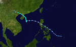
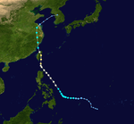
1990 Pacific typhoon season
| |
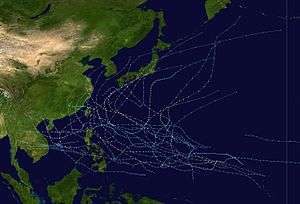
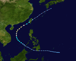
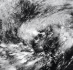
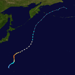
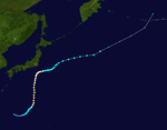
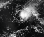
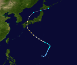
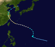
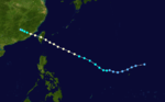
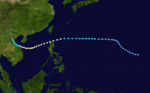
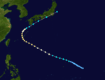
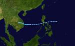
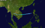
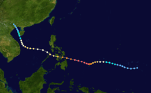
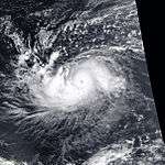
| Season summary map |
| First system formed |
January 12, 1990 |
| Last system dissipated |
December 23, 1990 |
| Strongest storm1 |
Flo – 890 hPa (mbar), 220 km/h (140 mph) (10-minute sustained) |
| Total depressions |
35 |
| Total storms |
32 |
| Typhoons |
18 |
| Super typhoons |
4 |
| Total fatalities |
>1,576 |
| Total damage |
$2.7 billion (1990 USD) |
| 1Strongest storm is determined by lowest pressure |
Pacific typhoon seasons
1988, 1989, 1990, 1991, 1992 |
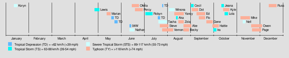
The 1990 Pacific typhoon season has no official bounds; it ran year-round in 1990, but most tropical cyclones tend to form in the northwestern Pacific Ocean between May and November.[1] These dates conventionally delimit the period of each year when most tropical cyclones form in the northwestern Pacific Ocean.
The scope of this article is limited to the Pacific Ocean, north of the equator and west of the international date line. Storms that form east of the date line and north of the equator are called hurricanes; see 1990 Pacific hurricane season. Tropical Storms formed in the entire west Pacific basin were assigned a name by the Joint Typhoon Warning Center. Tropical depressions in this basin have the "W" suffix added to their number. Tropical depressions that enter or form in the Philippine area of responsibility are assigned a name by the Philippine Atmospheric, Geophysical and Astronomical Services Administration or PAGASA. This can often result in the same storm having two names.
Season summary
Storms
35 tropical cyclones formed this year in the Western Pacific, of which 32 became tropical storms. 18 storms reached typhoon intensity, of which 4 reached super typhoon strength.
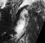
Severe Tropical Storm Koryn
| Severe tropical storm (JMA) |
| Category 1 typhoon (SSHWS) |
|
|
| Duration |
January 12 – January 17 |
| Peak intensity |
100 km/h (65 mph) (10-min) 980 hPa (mbar) |
On January 12, both the JMA and the JTWC identified a tropical depression in the northwest Pacific Ocean. The depression intensified over the period of a day to become a tropical storm on January 13, when it received the name Koryn from the JTWC. According to them, but not the JMA, Koryn reached hurricane-equivalent strength on January 15, when it peaked in intensity. The storm then weakened quite rapidly until it became extratropical on January 17, at 0000 UTC.
Tropical Storm Lewis
| Tropical storm (JMA) |
| Tropical storm (SSHWS) |
|
|
| Duration |
April 28 – May 4 |
| Peak intensity |
65 km/h (40 mph) (10-min) 998 hPa (mbar) |
Tropical Storm Lewis was a minimal tropical storm that only held said intensity for two days.
Typhoon Marian
| Typhoon (JMA) |
| Category 2 typhoon (SSHWS) |
|
|
| Duration |
May 15 – May 19 |
| Peak intensity |
130 km/h (80 mph) (10-min) 965 hPa (mbar) |
CMA Tropical Depression 04
| Tropical depression (CMA) |
|
|
| Duration |
May 20 – May 23 |
| Peak intensity |
55 km/h (35 mph) (10-min) 1000 hPa (mbar) |
CMA Tropical Depression 05
| Tropical depression (CMA) |
|
|
| Duration |
May 24 – May 28 |
| Peak intensity |
55 km/h (35 mph) (10-min) 1000 hPa (mbar) |
Tropical Depression 04W
| Tropical depression (HKO) |
| Tropical depression (SSHWS) |
|
|
| Duration |
June 14 – June 16 |
| Peak intensity |
55 km/h (35 mph) (10-min) 995 hPa (mbar) |
Severe Tropical Storm Nathan (Akang)
| Severe tropical storm (JMA) |
| Tropical storm (SSHWS) |
|
|
| Duration |
June 14 – June 19 |
| Peak intensity |
100 km/h (65 mph) (10-min) 980 hPa (mbar) |
A tropical disturbance trekked across the Philippines in mid June, upon entering the South China Sea a depression formed. The depression was upgraded to Tropical Storm Nathan on June 16. Tropical Storm Nathan reached peak intensity of 65 mph (100 km/h) shortly before striking Hainan Island. In the South China Sea the Chinese ship Tien Fu sank killing 4 people. In southern China torrential rains caused flooding in Guangdong and Zhanjian Provinces killing 10 people, two people drowned in Macau due to high waves. Tropical Storm Nathan then continued northwestwards making a final landfall near the Vietnam/China border.[2]
Typhoon Ofelia (Bising)
| Typhoon (JMA) |
| Category 2 typhoon (SSHWS) |
|
|
| Duration |
June 16 – June 25 |
| Peak intensity |
120 km/h (75 mph) (10-min) 970 hPa (mbar) |
The monsoon trough spawned a tropical depression east of the Philippines on June 15. It tracked to the northwest then westward, slowly organizing into a tropical storm on June 18. Ofelia turned more to the northwest and became a typhoon on June 20. Paralleling the east coast of the Philippines, it reached a peak of 100 mph (155 km/h) winds before hitting Taiwan on June 23. Ofelia weakened over the country, and brushed eastern China before dissipating on June 25 near Korea. Ofelia caused heavy flooding throughout its track, resulting in at least 64 casualties.
Typhoon Percy (Klaring)
| Typhoon (JMA) |
| Category 4 typhoon (SSHWS) |
|
|
| Duration |
June 20 – June 30 |
| Peak intensity |
150 km/h (90 mph) (10-min) 950 hPa (mbar) |
Typhoon Percy, which developed on June 20, reached a peak of 135 mph winds while located a short distance east of the northern Philippines. Increasing vertical shear weakened Percy to a 95 mph typhoon before crossing extreme northern Luzon on the 27th, an area that felt the effects of Ofelia only days before. It remained a weak typhoon until hitting southeastern China on the 29th before dissipating on the 1st. Percy caused serious damage and flooding in the Carolina Islands and northern Philippines, amounting to 9 deaths.
Tropical Storm Robyn (Deling)
| Tropical storm (JMA) |
| Tropical storm (SSHWS) |
|
|
| Duration |
July 4 – July 13 |
| Peak intensity |
85 km/h (50 mph) (10-min) 992 hPa (mbar) |
CMA Tropical Depression 11
| Tropical depression (CMA) |
|
|
| Duration |
July 20 – July 23 |
| Peak intensity |
55 km/h (35 mph) (10-min) 1000 hPa (mbar) |
Severe Tropical Storm Tasha (Emang)
| Severe tropical storm (JMA) |
| Tropical storm (SSHWS) |
|
|
| Duration |
July 21 – August 1 |
| Peak intensity |
100 km/h (65 mph) (10-min) 980 hPa (mbar) |
65 mph Tropical Storm Tasha, which developed on July 22 and meandered through the South China Sea, hit southern China on the 30th, 75 miles east of Hong Kong. The storm caused torrential flooding in southern China, causing widespread damage and 108 fatalities.
Typhoon Steve
| Typhoon (JMA) |
| Category 4 typhoon (SSHWS) |
|
|
| Duration |
July 23 – August 3 |
| Peak intensity |
155 km/h (100 mph) (10-min) 940 hPa (mbar) |
Typhoon Vernon
| Typhoon (JMA) |
| Category 2 typhoon (SSHWS) |
|
|
| Duration |
July 26 – August 9 |
| Peak intensity |
140 km/h (85 mph) (10-min) 955 hPa (mbar) |
CMA Tropical Depression 14
| Tropical depression (SSHWS) |
|
|
| Duration |
July 26 – July 27 |
| Peak intensity |
55 km/h (35 mph) (1-min) 1000 hPa (mbar) |
Severe Tropical Storm Winona
| Severe tropical storm (JMA) |
| Category 1 typhoon (SSHWS) |
|
|
| Duration |
August 4 – August 11 |
| Peak intensity |
110 km/h (70 mph) (10-min) 975 hPa (mbar) |
The origins of Winona can be traced back to Severe Tropical Storm Tasha.
On August 2, the remnant low of Tasha, as a patch of thunderstorms over northeastern China, was pushed to the east by a weather front from the west. By August 4, Tasha entered the Yellow Sea, before being pushed south by an anticyclone off northeastern Korea, into the East China Sea.
Although the same system, Tasha was named Winona, as it started to strengthen into a tropical storm by August 7. It reached peak intensity with an eye-like feature on August 8, before landfalling over Japan the next day. Later, the remnants became extratropical.
Typhoon Yancy (Gading)
| Typhoon (JMA) |
| Category 2 typhoon (SSHWS) |
|
|
| Duration |
August 11 – August 23 |
| Peak intensity |
150 km/h (90 mph) (10-min) 950 hPa (mbar) |
Typhoon Yancy killed 12 people in the Philippines after a landslide destroyed a dormitory. In China, severe damage occurred and at least 216 people were killed.[3] 20 people were killed in Taiwan.[4]
Tropical Storm Aka
| Tropical storm (JMA) |
| Tropical storm (SSHWS) |
|
|
| Duration |
August 13 (Entered basin) – August 15 |
| Peak intensity |
75 km/h (45 mph) (10-min) 994 hPa (mbar) |
Typhoon Zola
| Typhoon (JMA) |
| Category 3 typhoon (SSHWS) |
|
|
| Duration |
August 15 – August 23 |
| Peak intensity |
140 km/h (85 mph) (10-min) 960 hPa (mbar) |
On August 15, a large area of convection associated with the inflow of developing Typhoon Yancy was cut off, as Yancy was moving too fast to the west for the convection in the east to be absorbed into Yancy. By August 16, the convection developed a mid to low level circulation, and developed into tropical storm by August 18. Zola intensified into a typhoon by the next day, before reaching peak intensity on August 21. By the next day, Zola made landfall over Japan, before dissipating north of Japan.
High winds and heavy rains produced by the storm killed three people and injured 22 others in Japan.
Typhoon Abe (Heling)
| Typhoon (JMA) |
| Category 2 typhoon (SSHWS) |
|
|
| Duration |
August 23 – September 2 |
| Peak intensity |
140 km/h (85 mph) (10-min) 955 hPa (mbar) |
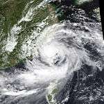
Forming on August 23 from a tropical disturbance, the depression which would eventually develop into Typhoon Abe initially tracked in a steady west-northwestward direction. As a result of an intense monsoon surge, the system's trajectory briefly changed to an eastward then northward path before returning to its original track. Abe only intensified by a small amount between 0000 UTC August 24 and 0600 UTC August 27 due to the disruptive effects of the surge, and on August 30, Abe peaked in intensity as a Category 2-equivalent typhoon on the Saffir–Simpson hurricane wind scale. After peaking in intensity, Abe crossed the Ryukyu Islands and the East China Sea, making landfall in China where it affected the provinces of Zhejiang and Jiangsu before entering the Yellow Sea, crossing South Korea, and finally transitioning into an extratropical cyclone.[5][6]
Typhoon Abe killed 108–195 people after it caused flooding and landslides in the Philippines and Taiwan, ravaged coastal areas of China, and brought high waves to Japan.[5][7][8] Abe, which is responsible for killing 108 in China, affected half of Zhejiang's land area and a fourth of its population, leaving thousands homeless and causing ¥3.5 billion yuan (RMB, $741.5–743 million USD) to be lost in damages.[6][8][9][10] Additional damage and one fatality occurred in Okinawa Prefecture in Japan, where at least ¥890 million yen (JPY, $6 million USD) in damage was caused.[7][11][12]
Typhoon Becky (Iliang)
| Typhoon (JMA) |
| Category 1 typhoon (SSHWS) |
|
|
| Duration |
August 23 – August 30 |
| Peak intensity |
130 km/h (80 mph) (10-min) 965 hPa (mbar) |
Tropical Storm Becky, having developed on August 20, hit northern Luzon on the 26th as a strong tropical storm. It strengthened over the South China Sea to an 80 mph typhoon, and hit northern Vietnam at that intensity on the 29th. Becky was responsible for killing 32 people and causing heavy flooding.
Tropical Storm Cecil
| Tropical storm (HKO) |
| Tropical storm (SSHWS) |
|
|
| Duration |
September 2 – September 5 |
| Peak intensity |
85 km/h (50 mph) (10-min) 990 hPa (mbar) |
Typhoon Dot (Loleng)
| Typhoon (JMA) |
| Category 1 typhoon (SSHWS) |
|
|
| Duration |
September 3 – September 11 |
| Peak intensity |
140 km/h (85 mph) (10-min) 960 hPa (mbar) |
Typhoon Dot formed from a monsoon trough to the southwest of Guam. Dot moved steadily towards the northwest and strengthened into a typhoon. Typhoon Dot reached peak intensity of 85 mph before weakening slight before landfall on eastern Taiwan on the 7th of September. After passing Taiwan Dot regained typhoon intensity in the Formosa Strait before making a final landfall in Fujian Province, China. On northern Luzon Island rains from Typhoon Dot caused floods killing 4 people, on Taiwan 3 people died.[2]
Typhoon Ed (Miding)
| Typhoon (JMA) |
| Category 2 typhoon (SSHWS) |
|
|
| Duration |
September 9 – September 20 |
| Peak intensity |
130 km/h (80 mph) (10-min) 965 hPa (mbar) |
Severe flooding produced by the storm killed at least 18 people in Vietnam. At least 4,500 homes were destroyed and another 140,000 were inundated.[13]
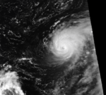
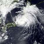
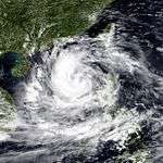
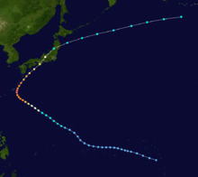
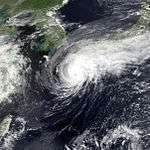
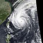
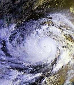
Super Typhoon Flo
| Typhoon (JMA) |
| Category 5 super typhoon (SSHWS) |
|
|
| Duration |
September 12 – September 20 |
| Peak intensity |
220 km/h (140 mph) (10-min) 890 hPa (mbar) |
Typhoon Flo, which developed on September 12, rapidly intensified on the 16th and 17th to a 165 mph super typhoon near Okinawa. Vertical shear weakened it as it recurved to the northeast, and Flo hit Honshū, Japan on the 19th as a 100 mph typhoon. It continued rapidly northeastward, became extratropical on the 20th, and dissipated on the 22nd. Widespread flooding and landslides killed 32 and caused millions in damage.
Typhoon Gene (Norming)
| Typhoon (JMA) |
| Category 1 typhoon (SSHWS) |
|
|
| Duration |
September 22 – September 30 |
| Peak intensity |
150 km/h (90 mph) (10-min) 950 hPa (mbar) |
A tropical disturbance consolidated into a tropical depression on the 23rd of September to the east of the Philippines. Tropical Storm Gene was named as the storm moved towards the northwest and strengthened into a typhoon the next day. Typhoon Gene reached peak intensity of 95 mph on the 27th shortly before recurving towards the northeast. Gene then skimmed the coasts of Kyūshū, Shikoku and Honshū Islands in Japan before moving out to sea and turning extratropical. Winds on 85 mph were recorded on Kyūshū and heavy rains fell across the region, resulting floods and landslides killed 4 people.[2]
Typhoon Hattie (Oyang)
| Typhoon (JMA) |
| Category 2 typhoon (SSHWS) |
|
|
| Duration |
September 30 – October 8 |
| Peak intensity |
150 km/h (90 mph) (10-min) 950 hPa (mbar) |
Typhoon Hattie formed as Typhoon Gene was accelerating towards Japan. Hattie strengthened into a typhoon on the 3rd of October while moving towards the northwest and reached a peak intensity of 105 mph the next day. Typhoon Hattie began to recurve while west of the island of Okinawa. Heavy rains from Typhoons Flo, Gene and Hattie broke the drought that plagued the island. As Hattie accelerated towards Japan it was downgraded to a tropical storm before brushing pass Kyūshū and Shikoku before making landfall on Honshū Island. Heavy rains caused a landslide on Shikoku Island killing three people when a landslide hit a bus.[2]
Tropical Storm Ira
| Tropical storm (JMA) |
| Tropical storm (SSHWS) |
|
|
| Duration |
October 1 – October 5 |
| Peak intensity |
65 km/h (40 mph) (10-min) 996 hPa (mbar) |
Severe flooding in Thailand triggered by heavy rains from Ira killed at least 24 people.[14]
Tropical Storm Jeana (Pasing)
| Tropical depression (HKO) |
| Tropical storm (SSHWS) |
|
|
| Duration |
October 12 – October 15 |
| Peak intensity |
55 km/h (35 mph) (10-min) 1000 hPa (mbar) |
Typhoon Kyle
| Typhoon (JMA) |
| Category 2 typhoon (SSHWS) |
|
|
| Duration |
October 14 – October 22 |
| Peak intensity |
140 km/h (85 mph) (10-min) 955 hPa (mbar) |
Tropical Storm Lola
| Tropical storm (JMA) |
| Tropical storm (SSHWS) |
|
|
| Duration |
October 16 – October 20 |
| Peak intensity |
65 km/h (40 mph) (10-min) 998 hPa (mbar) |
Extreme rainfall, peaking near 31.5 in (800 mm) triggered extensive flooding that left some regions under 6 ft (1.8 m) of water. At least 16 people were killed by the storm.[15]
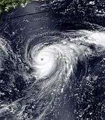
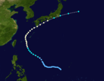
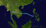
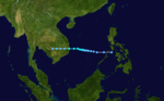
Super Typhoon Mike (Ruping)
| Typhoon (JMA) |
| Category 5 super typhoon (SSHWS) |
|
|
| Duration |
November 6 – November 18 |
| Peak intensity |
185 km/h (115 mph) (10-min) 915 hPa (mbar) |
Super Typhoon Mike was the deadliest typhoon of the season. It struck the central Philippines in mid-November, where landslides, flooding, and extreme wind damage to caused over 748 casualties and over $1.94 billion in damage (1990 USD).[16] The name Mike was retired after this season and replaced with Manny.
Severe Tropical Storm Nell
| Severe tropical storm (JMA) |
| Tropical storm (SSHWS) |
|
|
| Duration |
November 9 – November 12 |
| Peak intensity |
95 km/h (60 mph) (10-min) 990 hPa (mbar) |
Super Typhoon Owen
| Typhoon (JMA) |
| Category 5 super typhoon (SSHWS) |
|
|
| Duration |
November 20 – December 4 |
| Peak intensity |
175 km/h (110 mph) (10-min) 925 hPa (mbar) |
As Super Typhoon Owen crossed the Marshall Islands and Caroline Islands in mid to late November, it caused extreme damage to the many islands. Some islands lost 95%-99% of the dwellings, as well as 80-90% crops being destroyed. Through all of the damage, Owen only killed 2 people.[17]
Super Typhoon Page (Susang)
| Typhoon (JMA) |
| Category 5 super typhoon (SSHWS) |
|
|
| Duration |
November 21 – December 3 |
| Peak intensity |
195 km/h (120 mph) (10-min) 910 hPa (mbar) |
Super Typhoon Page formed on November 21 as a tropical depression. From there, it tracked slowly westward, making a cyclonic loop. Page continued westward, and strengthened into a Category 5 typhoon. It then accelerated northeastward, making landfall in Japan on November 30 as a Category 1 typhoon. Page dissipated over northeast Japan on December 3.[17]
Typhoon Russ
| Typhoon (JMA) |
| Category 4 typhoon (SSHWS) |
|
|
| Duration |
December 13 – December 23 |
| Peak intensity |
185 km/h (115 mph) (10-min) 915 hPa (mbar) |
The final storm of the season, which formed on December 13, brought heavy damage to Guam when it crossed near the island on December 20. Damage estimates are as high as $120 million (1990 USD), but nobody perished in the storm.
Storm names
During the season 30 named tropical cyclones developed in the Western Pacific and were named by the Joint Typhoon Warning Center, when it was determined that they had become tropical storms. These names were contributed to a revised list which started on mid-1989.
| Koryn | Lewis | Marian | Nathan | Ofelia | Percy | Robyn | Steve | Tasha | Vernon | Winona | Yancy | Zola | Abe | Becky |
| Cecil | Dot | Ed | Flo | Gene | Gene | Ira | Jeana | Kyle | Lola | Mike | Nell | Owen | Page | Russ |
Philippines
| Akang | Bising | Klaring | Deling | Emang |
| Gading | Heling | Iliang | Loleng | Miding |
| Norming | Oyang | Pasing | Ruping | Susang |
| Tering (unused) | Uding (unused) | Weling (unused) | Yaning (unused) | |
| Auxiliary list |
| | | | | Aning (unused) |
| Bidang (unused) | Katring (unused) | Delang (unused) | Esang (unused) | Garding (unused) |
The Philippine Atmospheric, Geophysical and Astronomical Services Administration uses its own naming scheme for tropical cyclones in their area of responsibility. PAGASA assigns names to tropical depressions that form within their area of responsibility and any tropical cyclone that might move into their area of responsibility. Should the list of names for a given year prove to be insufficient, names are taken from an auxiliary list, the first 10 of which are published each year before the season starts. Names not retired from this list will be used again in the 1994 season. This is the same list used for the 1986 season. PAGASA uses its own naming scheme that starts in the Filipino alphabet, with names of Filipino female names ending with "ng" (A, B, K, D, etc.). Names that were not assigned/going to use are marked in gray.
Retirement
Due to the severity of damage and loss of life caused by Mike, the name was retired and was replaced with Manny and was first used in the 1993 season. PAGASA also retired the name Ruping for similar reasons and was replaced with Ritang for the 1994 season.
See also
References
- ↑ Gary Padgett. May 2003 Tropical Cyclone Summary. Archived 2010-12-20 at WebCite Retrieved 2006-08-26.
- 1 2 3 4 Joint Typhoon Warning Center. Retrieved on 2007-12-26.
- ↑ http://www.apnewsarchive.com/1990/Typhoon-Yancy-s-Death-Toll-Reaches-216/id-081b7ae68b6bddce2da5f18ff039b653
- ↑ https://books.google.com/books?id=HhFUU33cliIC&pg=PA173&dq=%22Typhoon+Yancy%22&hl=en&sa=X&ei=xUZzVZ7COITggwSj9YPgBw&ved=0CC4Q6AEwAw#v=onepage&q=%22Typhoon%20Yancy%22&f=false
- 1 2 1990 Annual Tropical Cyclone Report (PDF) (Report). Pearl Harbor, Hawaii: Joint Typhoon Warning Center. 1991. Retrieved August 19, 2014.
- 1 2 Tropical Cyclones in 1990 (PDF) (Report). Hong Kong: Royal Observatory. February 1992. Retrieved June 2, 2015.
- 1 2 Digital Typhoon: Weather Disaster Report (1990-936-12). Digital Typhoon (Report) (in Japanese). National Institute of Informatics. Retrieved June 6, 2015.
- 1 2 "Commodity Briefs". The Journal of Commerce: 9A. September 7, 1990 – via LexisNexis. (subscription required (help)).
The typhoon hit the major wheat, sugar and cotton growing provinces of Zhejiang, Jiangsu and Anhui, as well as the city of Shanghai, on Aug. 31-Sept. 3, killing 108 people and causing 3.5 billion yuan (4.7 yuan=US$ 1) worth of damage, the China Daily said.
- ↑ DeAngelis, Richard A., ed. (February 1991). Mariners Weather Log: Winter 1991. 35. National Oceanographic Data Center. pp. 62 & 66.
There was no let–up as Abe came to life, on the 25th, 85 mi west southwest of Guam. Moving northward then west northwestward, Abe reached severe tropical storm strength on the 28th and became a typhoon the following day about 425 mi east southeast of Taipei. Abe moved across the Ryukyu Is and then made landfall about 150 mi south of Shanghai on the last day of the month." & "During Abe, one person was killed in Taiwan. On mainland China it was reported that 108 people lost their lives with another 40 reported missing. Zhejiang and Jiangsu provinces were hardest hit.
- ↑ "Storm Death Toll Rises to 88". Standard-Speaker. September 5, 1990. p. 3. Retrieved June 5, 2015 – via Newspapers.com.

- ↑ Digital Typhoon: Weather Disaster Report (1990-918-06). Digital Typhoon (Report) (in Japanese). National Institute of Informatics. Retrieved June 6, 2015.
- ↑ Digital Typhoon: Weather Disaster Report (1990-927-02). Digital Typhoon (Report) (in Japanese). National Institute of Informatics. Retrieved June 6, 2015.
- ↑ https://news.google.com/newspapers?id=BQIQAAAAIBAJ&sjid=ZZADAAAAIBAJ&pg=3560,3279443&dq=typhoon+ed+1990&hl=en
- ↑ http://pqasb.pqarchiver.com/latimes/access/60165154.html?dids=60165154:60165154&FMT=ABS&FMTS=ABS:FT&type=current&date=Oct+14%2C+1990&author=&pub=Los+Angeles+Times+(pre-1997+Fulltext)&desc=Thailand+Floods+Kill+24&pqatl=google
- ↑ http://nl.newsbank.com/nl-search/we/Archives?p_product=LB&p_theme=lb&p_action=search&p_maxdocs=200&p_topdoc=1&p_text_direct-0=0EAE8CA67548C254&p_field_direct-0=document_id&p_perpage=10&p_sort=YMD_date:D&s_trackval=GooglePM
- ↑ Philippine Atmospheric Geophysical and Astronomic Services Administration. Most Destructive Tropical Cyclones for Month of November (1948-2000). Retrieved on 2007-02-04.
- 1 2 Japan Meteorological Agency. Japan Meteorological Agency's Typhoons' Best Track (1990-1999). Retrieved on 2015-01-05.
External links