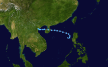
2009 Pacific typhoon season
 | |
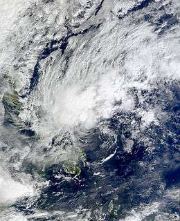
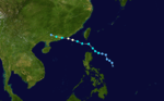
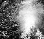
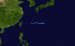
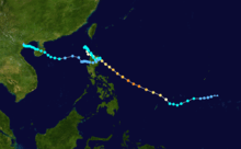
| Season summary map | |
| First system formed | January 3, 2009 |
|---|---|
| Last system dissipated | December 8, 2009 |
| Strongest storm1 | Nida – 905 hPa (mbar), 215 km/h (130 mph) (10-minute sustained) |
| Total depressions | 41 |
| Total storms | 22 |
| Typhoons | 13 |
| Super typhoons | 5 (unofficial) |
| Total fatalities | 2348 |
| Total damage | $9.97 billion (2009 USD) |
| 1Strongest storm is determined by lowest pressure | |
2007, 2008, 2009, 2010, 2011 | |
| Related articles | |
The 2009 Pacific typhoon season was the period that tropical cyclones formed in the Western Pacific Ocean. The season ran throughout the year during 2009, with most tropical cyclones forming between May and November. The scope of this article is limited to the Pacific Ocean, north of the equator between 100°E and the International Date Line. Tropical storms that form in the entire Western Pacific basin are assigned a name by the Japan Meteorological Agency. Tropical depressions that form in this basin are given a number with a "W" suffix by the United States' Joint Typhoon Warning Center. In addition, the Philippine Atmospheric, Geophysical and Astronomical Services Administration (PAGASA) assigns names to tropical cyclones (including tropical depressions) that enter or form in the Philippine area of responsibility. These names, however, are not in common use outside of the Philippines.
During the season, 39 tropical depressions developed within the Western Pacific, whilst two formed outside the region before moving into the Western Pacific.
Seasonal forecasts
| TSR forecasts Date | Tropical storms | Total Typhoons | Intense TCs | ACE Index | Ref |
|---|---|---|---|---|---|
| Average (1965–2008) | 26.6 | 16.7 | 8.6 | 300 | [1] |
| March 16, 2009 | 25.6 | 16.0 | 6.7 | 247 | [1] |
| May 7, 2009 | 27.5 | 17.6 | 9.1 | 319 | [2] |
| July 6, 2009 | 28.0 | 18.1 | 10.3 | 359 | [3] |
| August 4, 2009 | 26 | 18.2 | 10.6 | 367 | [4] |
| Other forecasts Date | Forecast Center | Tropical storms | Total Typhoons | Ref | |
| June 30, 2009 | CWB | 24–27 | – | [5] | |
| Actual activity | JMA | 22 | 13 | ||
| Actual activity | JTWC | 24 | 15 |
During each season, several national meteorological services and scientific agencies forecast how many tropical cyclones, tropical storms, and typhoons will form during a season and/or how many tropical cyclones will affect a particular country.[2] These agencies include the Tropical Storm Risk (TSR) Consortium of the University College London, Guy Carpenter Asia-Pacific Climate Impact Centre of the City University of Hong Kong (GCACIC) and Taiwan's Central Weather Bureau.[2][5]
On January 4, PAGASA reported that they were expecting 19 or less tropical cyclones to affect the Philippines during 2009.[6] During March, the TSR Consortium released their first forecast of the season and predicted that activity within the basin would be about 20% below normal with 25.6 tropical storms, 16 typhoons and 6.7 intense typhoons and an ACE index of around 247.[1] Later that month the Hong Kong Observatory, predicted that the typhoon season in Hong Kong would be near normal with five to six tropical cyclones passing within 500 km (310 mi) of the territory compared to an average of 6.[7] During April, the GCACIC issued its first seasonal forecast for the year and predicted that the season would see activity near its average with 31 tropical cyclones, 27 tropical storms, and 18 typhoons occurring during the season.[8] The GCACIC also predicted that 4 tropical cyclones would make landfall on Southern China between April and August compared to an average of 3, they also predicted that no tropical cyclones would make landfall between August and December.[8][nb 1] On May 7, TSR increased its forecast to 27.5 tropical storms, 17.6 typhoons, 9.1 "intense" typhoons and an ACE index of about 311 units, after La Nina conditions weakened and confidence grew that La Nina conditions would not return during 2009.[2] Later that month the Vietnamese National Center for Hydro Meteorological forecasts predicted that six or more tropical cyclones would affect Vietnam during 2009.[9]
During June, the GCACIC reported that the total number of tropical cyclones had decreased from 31 to 30, and that the total number of typhoons had increased to 19, while there was no change to the number of tropical storms predicted to occur during the season.[10] They also predicted that 3 tropical cyclones would make landfall on Southern China between July and December compared to an average of 4.[10] On June 30, the Taiwan Central Weather Bureau predicted that the season would see activity near its average of 26.6, and predicted that between 24 - 27 tropical storms would occur over the Western Pacific.[5] The Central Weather Bureau also predicted that of the 24-27 tropical storms forecast 3-5 of them would affect Taiwan.[5][11] In their July and August forecasts TSR upped their prediction for the amount of intense typhoons by one to ten and eleven respectively, whilst predicting the same amount of tropical storms and typhoons.[3][4] In July and August they also predicted that the season would now see activity about 20% above normal.[3][4] After their initial prediction was surpassed by Tropical Depression Tino forming, PAGASA announced that they expecting two or three more cyclones to affect the Philippines, before the end of the year.[12]
Storms

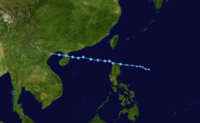
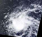
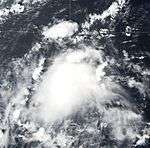
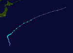
Tropical Depression Auring
| Tropical depression (JMA) | |||
|---|---|---|---|
| |||
| Duration | January 3 – January 6 | ||
| Peak intensity | 45 km/h (30 mph) (10-min) 1006 hPa (mbar) | ||
_2009_track.png)
Tropical Depression Auring formed as a tropical disturbance late on December 30, 2008, to the southeast of Manila in the Philippines.[13] Over the next few days the disturbance gradually developed before early on January 3, both PAGASA and the JMA, reported that the disturbance had intensified into the first tropical depression of the season with PAGASA assigning the name Auring to the depression.[13][14][15][16] As the depression was moving into a high level of vertical wind shear, it did not develop any further and late on January 5 as the baroclinic zone approached Auring, it was downgraded to a low-pressure area by PAGASA before the JMA followed suit the next day as it was declared as dissipated by the JTWC.[17][18][19][20]
Heavy rain from Auring produced severe flooding in the eastern Philippines.[21] Two people were killed and nine others were left missing.[22] A total of 305 homes were destroyed and another 610 were damaged.[23] In addition, an estimated 53 hectares (130.9 acres) of rice and 3.5 hectares (8.6 acres) of corn were damaged.[23] About 43,851 people were affected by the depression and damages were estimated at PHP 23 million (498 thousand USD).[24]
Tropical Depression Bising
| Tropical depression (PAGASA) | |||
|---|---|---|---|
| |||
| Duration | February 12 – February 13 | ||
| Peak intensity | 45 km/h (30 mph) (10-min) | ||
_2009_track.png)
Early on February 12, PAGASA reported that a low-pressure area located about 140 km (87 mi) to the east of Surigao City in the Philippines had intensified into a tropical depression.[25] During that day the depression gradually moved towards the west with its peak windspeeds estimated at 45 km/h (30 mph).[26] Early the next morning after the depression had made landfall on Dinagat Island, PAGASA released its final advisory as the depression had weakened into an area of low pressure.[27][28]
An estimated 473 passengers and several vehicles were stranded in Liloan and Ormoc due to ferry cancellations.[29] In Cebu, an estimated 1,600 passengers were also stranded due to the depression.[30] Late on February 13, the remnants of Bising brought scattered rainshowers across Southern Luzon, Bicol Region, and Visayas, then dissipated. The rainfall led to mudslides on Cebu Island which blocked the Cebu Transcentral Highway.[31]
Tropical Depression Crising
| Tropical depression (PAGASA) | |||
|---|---|---|---|
| |||
| Duration | April 30 – May 1 | ||
| Peak intensity | 55 km/h (35 mph) (10-min) | ||
_2009_track.png)
On April 29, the JTWC reported that an area of deep convection had persisted near the center of an elongated low-level circulation center, in area of low vertical windshear, about 400 km (250 mi), to the west of Manila in the Philippines. Deep convective banding was curving into an eastern southern edges of the disturbance.[32] During the day the disturbance gradually consolidated further under the influence of an anticyclone, as a result of this the JTWC issued a tropical cyclone formation alert on the system.[33] Early the next morning PAGASA upgraded the disturbance to a tropical depression and named it as Crising as it reached its 10-minute peak windspeeds of 55 km/h (35 mph).[34] Later that day the JTWC reported that Crising's low-level circulation center has weakened and was now poorly organized as it underwent a Fujiwhara effect with what was to become Typhoon Kujira (Dante).[35] PAGASA kept issuing advisories on Crising until it weakened into a low-pressure area early on May 1.[36]
Heavy rains produced by the outer bands of Crising caused flooding in western areas of the Philippines, affecting an estimated 2,500 people. The worst flooding occurred in Lucena City where ten villages were isolated. Areas along the Bucon and Inalmasinan Rivers were inundated and sustained significant crop losses. Several animals reportedly drowned in the region. Several roads were impassable due to landslides or were washed out by floodwaters. One bridge was destroyed in the town of Mercedes.[37]
Typhoon Kujira (Dante)
| Typhoon (JMA) | |||
|---|---|---|---|
| Category 4 typhoon (SSHWS) | |||
| |||
| Duration | May 1 – May 7 | ||
| Peak intensity | 155 km/h (100 mph) (10-min) 940 hPa (mbar) | ||


Early on April 26, an area of disturbed weather formed near the coastline of Baler, capital of the Philippine's Aurora province. It was formerly a tail end of cold front that passed by Northern Luzon. JTWC assessed that the area of a disturbed weather potential of becoming developing into a significant Tropical Cyclone within 24 hours as "fair". However, on April 28, JTWC downgraded the disturbance as dissipating because of interaction with nearby middle Tropical Depression Crising and JMA Tropical Depression 03. A few days later, the disturbance moved south-westward, and late on April 30, the disturbance made landfall at Albay. On May 1, JTWC again upgraded the disturbance into having a potential to form into a significant Tropical Cyclone within 24 hours to "fair". And later that day, PAGASA classified the disturbance as a tropical depression, naming it "Dante" and issued public storm warning signal number one in the provinces of Camarines Norte, Camarines Sur, Albay, Sorsogon, Catanduanes, Masbate, Burias Island, and Southern Quezon.[38] PAGASA also reported that Dante made landfall in the vicinity of Sorsogon within the Bicol region of the Philippines. Early on May 2, JTWC issued a TCFA as the depression was in an almost stationary position. Later that day, JMA classified Dante as a full depression. Early the next morning it became a tropical storm and was named Kujira. Kujira continued to strengthen and was upgraded to a severe tropical storm that afternoon. When it was over the Philippines it killed 27 people while 9 others are missing.[39] The JMA upgraded the system to a typhoon early on May 4. Kujira intensified quickly, doubling in strength from a Category 2 typhoon to a Category 4-equivalent typhoon within 24 hours. On May 6, The JTWC reported that Kujira was in its beginning stages of becoming extratropical, with the low-level circulation center almost fully exposed in association with increasing vertical wind shear and lower sea surface temperatures in the region. Late that, JMA downgraded Kujira to a Severe Tropical Storm as strong wind shear weakens the system. Then early on May 7, JTWC issued its last advisory on Kujira, already reporting it as an extratropical system. JMA continued to issue warnings on the system while at the same time it was downgraded to a tropical storm. Later on May 7, Kujira weakened further, becoming a fully extratropical cyclone .
While in the Philippine area of responsibility, Kujira caused some 625,709,464 worth of damage to crops and livestock in Albay, Camarines Norte, Masbate and Sorsogon. It also caused some 102 million pesos worth of damage to communal irrigation systems in the region.[40] The NDCC update as of 6AM PST May 12 declared 28 dead, one missing and 5 injured. Further, 383,457 persons in 609 barangays of 60 municipalities and 4 cities in 5 provinces of Region V were affected by the storm. Damages are worth PhP 1,228,422,344 million or PhP1.228 billion of which PhP 625,709,464 are agricultural losses and PhP 529.525 million in infrastructural. Houses destroyed were at 2387, of which 138 were total and 2249 partial.[41]
Tropical Depression
| Tropical depression (JMA) | |||
|---|---|---|---|
| |||
| Duration | May 1 – May 4 | ||
| Peak intensity | 55 km/h (35 mph) (10-min) 1004 hPa (mbar) | ||

Late on April 28, the JTWC reported that an area of disturbed weather had persisted in an area of low vertical windshear to the southeast of Yap.[42] Deep convection was wrapping into a poorly organized but consolidating low-level circulation center.[42] However over the next few days its low-level circulation center weakened with convection becoming very shallow and disorganised before it was declared as a Tropical depression on May 1 by the JMA.[43][44] The JTWC then released a Tropical Cyclone Formation Alert early the next day as the low-level circulation center had become well defined and convection increased with sea surface temperatures also becoming favourable for development.[45] However the alert was cancelled later that day after the depression had peaked at 55 km/h (35 mph), as the low-level circulation center had started to move under the upper-level jet located to the north of the depression which had caused the vertical windshear over the system to increase.[46][47] As a result of this the low-level circulation center began to detach from the convection and was losing its tropical characteristics and was predicted to become a very strong extratropical low.[47] However the JMA continued to issue advisories on the depression until early on May 4, when they downgraded it to an extratropical low.[48][49] The remnants of the depression continued to move north west until it nearly reached the jet stream and stalled there for 3 days. Late on May 7, the extratropical remnants of the Tropical Depression dissipated completely.
Typhoon Chan-hom (Emong)
| Typhoon (JMA) | |||
|---|---|---|---|
| Category 2 typhoon (SSHWS) | |||
| |||
| Duration | May 2 – May 9 | ||
| Peak intensity | 120 km/h (75 mph) (10-min) 975 hPa (mbar) | ||
On May 1, an area of convectional cloudiness associated with an area of disturbed weather formed southeast of Nha Trang, Vietnam and associated with a remnant of Tropical depression Crising to form a new stronger area of disturbed weather system. JTWC monitored the disturbance as "Fair" for developing due to low vertical wind shear and an upper-level anticyclone to the east of the system. Later on the JMA designated the low pressure as a minor tropical depression reporting the outlook track as southwestward. The JTWC issued a TCFA on the system once the convection increased and became better organized although with an exposed LLC east of its convection. Early morning of May 3, the JMA begun issuing tropical cyclone advisories on the system forecasting it to become a tropical storm later in the afternoon as it tracked eastwards. On May 3, the JTWC designated the disturbance as Tropical Depression 02W, and the JMA named the storm Chan-hom. Later on May 4, Chan-hom strengthened into a severe tropical storm. On May 6, the system moved into the Philippine Area of Responsibility from the west and was named as Emong. Later that day the JMA upgraded the severe tropical storm to a typhoon. On May 7, PAGASA reported that Chan-hom had made landfall at the northern tip of Bani, Pangasinan. After traversing Pangasinan it lashed La Union, Ilocos Sur, Benguet, Nueva Vizcaya, Ifugao, Mt. Province, Kalinga and Isabela. Pangasinan (which recorded 150mm of rain from Emong) and La Union were the worst hit. The provinces in Central Luzon, Ilocos, Cordillera Administrative Region and Cagayan Valley, together with Metro Manila and parts of Southern Luzon, generally experienced more than 100 mm in the 24‑hour period on May 7. Rains, however, lasted from May 6–8. NDCC updates on 6:00AM on May 13 put dead at 50, injured at 47 and missing at 13 and damage worth 690 million pesos in agriculture, infrastructure and private property. It further left 204,000 persons affected, damaged 23280 houses of which 6080 are totally damaged and 17200 partially damaged in Pangasinan and induced 11 landslide occurrences in Zambales and Cagayan[50] PAGASA expected the typhoon to weaken quickly, which it did.[51] On May 8, Chan-hom was downgraded to a Tropical Storm and later, to a Tropical Depression. JMA issued its last warning early on May 9, followed by the JTWC. PAGASA held on to Emong (Chan-hom) until much later that day, when it was declared an area of low pressure. JTWC then re-issued advisories on the restrengthening depression on May 10. Later on May 11, Chan-hom became a subtropical depression, therefore, JMA and PAGASA designated it a tropical depression while JTWC declared it dissipated, PAGASA reported Tropical Depression Chan-hom degenerated into Subtropical Disturbance ex-Chan-hom and issued the final advisory for the system because it had almost completely dissipated. However, JMA did not issue the final advisory for the tropical depression until early on May 13, when then circulation dissipated and it began accelerate northeastward in association of the jet stream and it was forecast to become extratropical or be absorbed by a cold front.
Severe Tropical Storm Linfa
| Severe tropical storm (JMA) | |||
|---|---|---|---|
| Category 1 typhoon (SSHWS) | |||
| |||
| Duration | June 14 – June 23 | ||
| Peak intensity | 110 km/h (70 mph) (10-min) 975 hPa (mbar) | ||

On June 10, the JTWC began monitoring an area of disturbed weather that was situated about 140 km (87 mi) southeast of Palau.[52] The disturbance had an elongated low-level circulation, with deep convection centered along the southwestern portion of the system.[52] Over the next couple of days, the disturbance gradually developed with the JMA declaring the system as a tropical depression early on June 14 whilst the JTWC issued a TCFA.[53][54] However the TCFA was cancelled later that day due to the convection dissipating, whilst the JMA downgraded the depression to an area of low pressure.[55][56] Over the next two days, the system moved across Luzon and began to regenerate.[57] Early on June 17, a second TCFA was released by the JTWC whilst the JMA reported that the system had re-intensified into a tropical depression.[58][59] Later that day, the JTWC designated the system as Tropical Depression 03W whilst the storm was situated about 705 km (438 mi) south-southwest of Kaohsiung, Taiwan.[60] Following further development of the depression, the JTWC upgraded it to a tropical storm late on June 17.[61] The JMA then followed suit early the next morning assigning the name Linfa to the storm.[62] Throughout the rest of the day limited poleward outflow prevented linfa from intensifying.[63] During June 19, Linfa intensified further and became a severe tropical storm with an eye feature starting to appear on microwave imagery.[64][65] After interacting with a nearby upper-level low, outflow significantly improved later that day, fueling further strengthening, before the next day the JTWC upgraded Linfa to a typhoon as it reached its peak windspeeds of 140 km/h (85 mph) 110 km/h (70 mph 10-minute winds).[66][67][68] Later that day convection near the center of the circulation to decrease with the eye no longer visible. Upper-level wind shear rapidly increased, preventing re-intensification of the cyclone.[69] Linfa then began to interact with land and was downgraded to a tropical storm by the JTWC on June 21 and then during that afternoon the storm made landfall on the southern Chinese provence of Fujian.[70][71] Deep convection then rapidly dissipated with both the JMA and the JTWC downgrading Linfa to a Tropical depression by early on June 22, as the storm moved away from the Chinese coastline.[72][73] The system later dissipated just offshore with a circulation was no longer evident on satellite imagery.[74]
A total of seven people were killed by Linfa, whilst $110 million (2009 USD) worth of damage was done by Linfa, as it affected China, Taiwan, Hong Kong and the Philippines. A 498-tonne oil tanker was run aground in southern Taiwan by large swells of up to 5.6 m (18 ft). In Taiwan two people were hit by fallen trees, whilst power cuts were reported in Chiangchun as well as other parts of China and Taiwan. A total loss of NT$400 million, (12.1 million 2009 USD) was suffered by the agricultural sector in Taiwan whilst in mainland China, Linfa produced torrential rainfall which led to severe flooding. Following a landslide, one person was killed. Flood waters destroyed 100 homes and inundated 10,000 others as well as an estimated 32,000 hectares of farmland in Fujian Province. In Meizhou, Guongdong Province, flash flooding resulted in five additional fatalities after 413.7 mm 19.22 in of rain fell within a nine-hour span. A total of 362 homes were destroyed in the town and infrastructure was severely damaged. Additionally, an estimated 20 million people were affected by the storm.
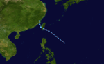
Tropical Storm Nangka (Feria)
| Tropical storm (JMA) | |||
|---|---|---|---|
| Tropical storm (SSHWS) | |||
| |||
| Duration | June 22 – June 27 | ||
| Peak intensity | 75 km/h (45 mph) (10-min) 994 hPa (mbar) | ||

On June 16, an area of disturbed weather formed about 170 km (110 mi) to the northeast of Palau Island. In the next few days, the disturbance showed improvement but, its LLCC was undefined.[75] Early on June 20, the disturbance suddenly strengthened and its LLCC began to consolidate as well as significant banding all over the system.[76] The disturbance was also located under low vertical wind shear. Early on June 22, JTWC issued an advisory that the potential of the formation of a significant tropical cyclone within 24 hours was upgraded to "Fair" because of its well-defined LLCC and was located in a favorable area.[77] Around 0600 UTC that same day, the JMA classified the disturbance as a minor Tropical Depression,[78] while the JTWC released a TCFA on the disturbance. This was because convection had begun to organize and upper-level analysis showed a cyclonic center on the east, just west of Guam and a cyclonic flow around its consolidating low-level circulation Centre. After 4 hours, JTWC issued its first warning and named it as Tropical Depression 04W. Early on June 23, PAGASA issued its first warning on the Tropical Depression and assigned its local named "Feria". In the afternoon, Nangka made its first landfall over Hernani, Eastern Samar at 5:00 pm PST (0900 UTC). and made its second landfall in Masbate around 10:00PM PST ( 1400 UTC). On June 24, Nangka rapidly slowed down while moving over Mindoro. The storm then made its third landfall at Calapan City, Mindoro at 12 am PST/ 0430 UTC. After crossing Mindoro for 8 hours, PAGASA downgraded Nangka into a Tropical Depression, while both the JMA and JTWC still classified Nangka as a tropical storm on that day. Early on June 25, Nangka move into the South China Sea, with PAGASA issuing their final warning. In the evening of that same day, both JMA and JTWC downgraded Nangka into a tropical depression due to its low-level circulation center is started to deteriorate. By midday of June 26, it made its fourth landfall in Guangdong province in China, passing through the northern part of Hong Kong. In the afternoon of that day, both JMA and JTWC issued their final warning on Nangka. Its remnants completely dissipated by June 27.
In Eastern Samar, more than 800 people were stranded after ferry service was canceled.[79] High winds downed a large tree, destroying the roof of one home and damaging three cars.[80] Unusually strong severe thunderstorms developed over parts of the Philippines along the outer bands of Nangka. In San Pascual, Bauan and Batangas City, large hail fell during a strong storm. Residents reported that they have never seen hail before. In Barangay, 4 in Bauan town, a rare tornado struck, downing several trees, damaging homes and signs. Heavy rains produced by the storm also flooded numerous regions, some reporting waist-deep water.[81] Later reports confirmed the tornado destroyed 23 homes. In Cebu, one person was killed and seven were left missing.[82] At least 500 people were also left homeless due to the storm.[83] In Cavite,7000 was stranded on the port due to Nangka's winds and heavy rains. about 4 feet (1.2 m) is the water wave in Cavite.[84] In Albay, more than 300 ship passengers were also stranded at the Albay port, Tabaco, Albay.[85] In Navotas and Malabon, the Navotas — Malabon river produced a 3-foot (0.91 m) high tide in the area.[86]
As of 24 June, Nangka (Feria) has caused 6 deaths and left 11 people missing. Property damage from the storm is estimated at PHP 2.8 million (US$54,000).[87]
Tropical Storm Soudelor (Gorio)
| Tropical storm (JMA) | |||
|---|---|---|---|
| Tropical storm (SSHWS) | |||
| |||
| Duration | July 9 – July 13 | ||
| Peak intensity | 65 km/h (40 mph) (10-min) 992 hPa (mbar) | ||

Late on July 7, the JTWC reported that an area of disturbed weather had formed about 900 km (560 mi) to the northwest of Yap. Deep convection was embedded in a broad, weak, poorly defined circulation that was starting to be enhanced by a Tropical Upper Tropospheric Trough (TUTT) cell to the east of the system.[88] Over the next couple of days, gradual development took place before a TCFA was released by the JTWC early on July 9 as PAGASA designated the system as Tropical Depression Gorio.[89][90][91] Later that day both the JMA and the JTWC reported that the depression had formed and started to issue warnings on the depression, with the JTWC designating it as 05W.[92][93] On July 10, PAGASA issued their final advisory on Tropical Depression Gorio as it moved out of their area of responsibility.[94] Hampered by an unfavorable upper-level environment, the depression barely intensified into a tropical storm early on July 11.[95] Upon becoming a tropical storm, the JMA named the system Soudelor reporting peak winds of 65 km/h, (40 mph).[93][96] Later that day the JTWC reported that Soudelor had weakened into a depression; however they re-upgraded it to a tropical storm as it moved closer to Hainan Province.[97][98] Shortly before landfall in Leizhou Peninsula, China, the JTWC downgraded the storm to a tropical depression, then as Soudelor moved back over water and into the Gulf of Tonkin, the JTWC issued their final advisory on the depression, however the JMA continued to monitor the storm until it had made landfall near Fangchenggang, China several hours later.[99][100][101]
As a tropical depression, Soudelor brushed northern Luzon in the Philippines, producing upwards of 330 mm (13 in) of rainfall which resulted in flash flooding and landslides in at least ten villages.[102][103][104] In China torrential rains in Hainan caused significant flooding that killed 15 hikers and left several others missing. Numerous roads were also cut off or destroyed by landslides and 30 villages were inundated with flood waters.[105] The remnants of Soudelor produced widespread torrential rains in Northern Vietnam on July 13. Rainfall totals peaked at 250 mm (9.8 in) in the region.[106] Heavy rainfall, amounting to 130 mm (5.1 in), was also recorded in Hanoi. The capital city experienced flash flooding, inundating numerous streets and buildings. Two men were killed by lightning strikes associated with the storm. Officials reported that at least 13 large trees had been downed by high winds.[107] Flood waters in the hardest-hit areas reached a depth of 0.35 m (1.1 ft). One person was killed after being swept away. A tornado also touched down during the storm, destroying the roofs of three homes. Thousands of hectares of croplands were inundated by flood waters. Following the storm, 1,000 tonnes of rice was allocated for victims of the floods.[108]
Tropical Depression 06W (Huaning)
| Tropical depression (JMA) | |||
|---|---|---|---|
| Tropical depression (SSHWS) | |||
| |||
| Duration | July 11 – July 14 | ||
| Peak intensity | 55 km/h (35 mph) (10-min) 1000 hPa (mbar) | ||
On July 10, the JTWC reported that an area of disturbed weather had persisted about 1,065 km (662 mi) to the east of Manila. The convection was consolidating with a good mid-level circulation and was located under an anticyclone and had started to show some outflow into a trough to the northeast of the system. Early the next day the JMA reported that the disturbance had become a minor tropical depression. The depression then gradually developed during the rest of July 11, with PAGASA naming the depression as Huaning early on July 12 whilst the JTWC issued a Tropical Cyclone Formation Alert on the depression. Early the next day PAGASA upgraded Huaning into a tropical storm whilst the JTWC designated the depression as Tropical Depression 06W. Later that morning Huaning made its first landfall over Taitung City, Taiwan. On the next day, both JMA and JTWC issued their final warning on Huaning.
Typhoon Molave (Isang)
| Typhoon (JMA) | |||
|---|---|---|---|
| Category 1 typhoon (SSHWS) | |||
| |||
| Duration | July 14 – July 19 | ||
| Peak intensity | 120 km/h (75 mph) (10-min) 975 hPa (mbar) | ||
Late on July 10, an area of disturbed weather persisted about 280 km (170 mi), to the southeast of Yap. Convection was wrapping into a poorly organized and drawn out low-level circulation center and was under minimal wind shear. It gradually developed further throughout the next day with convection continuing to consolidate over a low-level circulation center. However early on July 12, the JTWC reported that the disturbance had dissipated, as outflow was being hampered by the outflow of Huaning. However late on July 13, the JTWC reported that the disturbance had rapidly redeveloped and released a TCFA on the disturbance. Early the next day both PAGASA and the JMA designated the disturbance as a Tropical Depression with PAGASA assigning the local name of Isang to the depression. The Depression continued to develop and was designated as Tropical Depression 07W by the JTWC early on July 15, whilst PAGASA upgraded Isang to a Tropical storm later that day. On July 17, JMA upgraded Molave as a Severe Tropical Storm and Typhoon by PAGASA. On morning of July 18, HKO upgraded Molave as a Typhoon. Later that day, Molave quickly moved into the South China Sea. On July 19, at 1700 UTC or 1am HKT, Molave made its first landfall. On the afternoon, as Molave move through China, both JMA and JTWC issued their final warning as Molave weakened into a Tropical depression. Molave killed at least four people.[109]
Tropical Storm Goni (Jolina)
| Tropical storm (JMA) | |||
|---|---|---|---|
| Tropical storm (SSHWS) | |||
| |||
| Duration | July 30 – August 9 | ||
| Peak intensity | 75 km/h (45 mph) (10-min) 988 hPa (mbar) | ||

Late on July 25, the JTWC reported that an area of convection had formed in a monsoon trough about 815 km (506 mi) to the northeast of Guam.[110] Deep convection was flaring around the low-level circulation center.[110] An upper-level anticyclone and a tropical upper tropospheric trough was providing outflow.[110] Over the next few days the disturbance gradually developed before the disturbance was declared as dissipated early on July 28 as the low-level circulation center was not well defined and higher vertical wind shear affecting the system. However the disturbance regenerated early on July 30 whilst located about 630 km (390 mi), the disturbance's low-level circulation center was elongated with indications of multiple circulation centers. Later that day PAGASA reported that the disturbance had developed into a tropical depression and assigned its local name of Jolina. Jolina then intensified further early the next day and was reported to have become a tropical storm by PAGASA, with the JMA designating it as a depression later that day. Early on August 1 the JTWC issued a Tropical Cyclone Formation Alert as deep convection had increased and was starting to consolidate around a circulation center. However, later that morning Jolina made a landfall near to Casiguran, in the Philippine province of Aurora before emerging out into the South China sea later that day. Early the next day the JTWC reissued their TCFA whilst PAGASA issued their final warning on Jolina as it moved out of their area of responsibility heading towards a landfall on China. The JTWC then designated the depression as 08W later that day as infrared imagery had shown deep convection was wrapping into the low-level circulation center. During August 3, the JMA reported that the tropical depression had intensified into a tropical storm and assigned the Goni to the cyclone. At 1700 UTC of August 4, Goni made its second landfall over Macau. Early on the next day, JTWC issued their final warning on Goni. On August 7, The Joint Typhoon Warning noted that remnant of Goni re-entered into the Gulf of Tonkin and had a poor chance of regenerating. Later in the day, Joint Typhoon Warning Center reissued advisories on the system upgrading it to a tropical storm near Hainan Island.
In the Philippines Goni (Jolina) death toll is 8 with 5 more missing. Goni (Jolina) affected 38,589 families or 160,038 people in 119 villages in 25 towns and five cities in Ilocos Sur, Batangas, Cagayan, Nueva Ecija, Rizal, Mindoro Occidental, Palawan, Iloilo, Negros Occidental, Lanao del Sur, and Sultan Kudarat town in Maguindanao.[111] Five people died in China when Goni passed through. In Hainan province about 92,000 people had been evacuated by the authorities. 575 houses got destroyed and 2,311 damaged. The storm also inundated than 68,000 hectares cropland.[112]
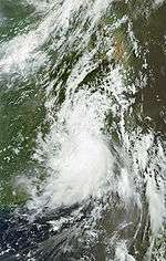
Typhoon Morakot (Kiko)
| Typhoon (JMA) | |||
|---|---|---|---|
| Category 1 typhoon (SSHWS) | |||
| |||
| Duration | August 2 – August 11 | ||
| Peak intensity | 140 km/h (85 mph) (10-min) 945 hPa (mbar) | ||

The season's deadliest tropical cyclone formed early on August 2, within a monsoon trough about 1,000 km (620 mi) east of the Philippines.[113][114] The depression remained weak, however, and later that day the JMA downgraded it to an area of convection.[115][116] Still later that day, the JMA reported that the tropical depression had regenerated[117] and that deep convection was flaring on the western side of a partially exposed low-level circulation center.[114] On August 3, PAGASA named the depression Kiko as it moved through their area of responsibility, after which (the same day) the JMA named the storm Morakot, upgrading it to a Tropical Storm. The JTWC followed suit, designating Morakot as 09W. The next day Morakot recurved, reentering PAGASA's area of responsibility.
In the Philippines, ten villages (Paudpod, San Juan, Batonloc, Carael, Tampo, Paco, San Miguel, Bining, Bangan, and Capayawan) have been submerged in 4-to-5-foot-deep (1.2 to 1.5 m) floods after the Pinatubo Dike overflowed.[118] Joint military and police rescue teams rescued 3 Koreans and 9 Canadian nationals. About 30,000 families were affected by Morakot; eleven people are confirmed dead.[119][120] Three French tourists and two Filipino guides were killed in a flashflood caused by a landslide. Thousands are trapped on rooftops or in trees awaiting helicopter rescue attempts and thousands have lost their homes. At least two have died from flooding. Landslides have claimed the lives of two children and five miners are still missing after a landslide destroyed their huts. Schools have suspended their classes in the hardest hit area, and highways have been closed due to landslides.[121]
In Taiwan, where schools were closed ahead of the typhoon, Morakot caused landslides, severe floods, blew down trees and billboards, and stripped roofs from buildings. In a positive impact, Morakot brought much-needed rain to Taiwan, ending a months-long drought, and replenished reservoirs enough to warrant an end to water rationing.[122] In Taiwan, 461 people were killed with 192 missing. Almost the entire southern Taiwan (Chiayi, Tainan, Kaohsuing, and Pingtung) are flooded by record-breaking heavy rain. It is estimated that rainfall in Pingtung county may reach as much as 2,500 millimeters, breaking all rainfall records of any single place in Taiwan induced by a single typhoon.[123]
South east China has evacuated 20,000 residents. A fishing boat has capsized and search and rescue efforts have begun for nine missing fishermen.[124] A total of 34000 watercraft sought refuge ahead of the storm.[125]
Tropical Storm Etau
| Tropical storm (JMA) | |||
|---|---|---|---|
| Tropical storm (SSHWS) | |||
| |||
| Duration | August 8 – August 14 | ||
| Peak intensity | 75 km/h (45 mph) (10-min) 992 hPa (mbar) | ||

On August 6, an area of convectional cloudiness associated with monsoon through was located about (620 miles) 1000 km southwest of Iwo To, Japan. Satellite imagery shows an TUTT was located to the northeast of the system. and the system is also located under high vertical wind shear and favorable environment. Late of August 7, JTWC upgraded the system and issued a TCFA because LLCC is partially exposed. while JMA also upgraded the system as a minor tropical depression. On the next day, both JMA and JTWC classifies the minor tropical depression as a full depression. On August 8, JMA upgraded the system as a tropical storm and assigned the name Etau.
In post-storm analysis, the JMA downgraded Etau to a tropical storm, with peak winds of 75 km/h (45 mph).[126]
Tropical Depression Maka
| Tropical depression (JMA) | |||
|---|---|---|---|
| Tropical storm (SSHWS) | |||
| |||
| Duration | August 13 (entered basin) – August 17 | ||
| Peak intensity | 55 km/h (35 mph) (10-min) 1006 hPa (mbar) | ||
On August 13, the remnants of Tropical Storm Maka crossed the international dateline and moved into the Western Pacific; where it was immediately designated as a tropical depression by the JMA. Later that day the JTWC reported that the depression was located about 1,425 km (885 mi) to the southeast of Wake Island, with deep convection developing over the northern quadrant of a stretched out, low-level circulation center which was in an area of low to moderate vertical wind shear and had a good outflow into an upper-level trough. During the next day, the JTWC issued a Tropical Cyclone Formation Alert on the depression as the low-level circulation center had developed further.[127] Later that day, the JTWC re-upgraded the disturbance to Tropical Depression 01C (Maka).[128] Late the next day the JTWC upgraded the depression to a tropical storm however, the JMA still classified the storm as a depression.
Typhoon Vamco
| Typhoon (JMA) | |||
|---|---|---|---|
| Category 4 typhoon (SSHWS) | |||
| |||
| Duration | August 16 – August 26 | ||
| Peak intensity | 165 km/h (105 mph) (10-min) 945 hPa (mbar) | ||

On August 13, the JTWC reported that an area of deep convection had persisted in an area of low vertical wind shear about 415 km (258 mi), to the north of Kwajalein Atoll.[129] A low-level circulation center was developing with the deep convection starting to wrap into it whilst a tropical upper tropspheric trough was providing a good outflow for the center.[129] Over the next couple of days the convection started to consolidate before early on August 16 a TCFA was issued by the JTWC as convective bands had started to wrap into the low-level circulation center.[130] It was then declared as a Tropical depression later that day by the JMA however the JTWC did not follow suit until early the next day when they designated the depression as 11W with convective bands wrapping into a well-defined low-level circulation center.[131] Both the JTWC and the JMA upgraded it to a tropical storm later that day, with the JMA assigning the name Vamco to the storm.[131][132]
During August 18, the JMA reported that Vamco had intensified into a severe tropical storm and was moving towards the northwest slowly before early the next day along with the JTWC reporting that it had intensified into a weak typhoon.[131][132] During that day Vamco kept intensifying due to being in favorable conditions with the JMA reporting that the typhoon had reached its peak wind speeds early on August 20 of 165 km/h, (105 mph) 10-min Sustained, however the JTWC reported that it had continued to intensify during August 20, and reached its 1-minute peak wind speeds of 215 km/h, (130 mph) early on August 21 which made it a category four typhoon on the Saffir–Simpson Hurricane Scale.[131][132] Vamco stayed at its peak wind speeds until early on August 22 when both the JMA and the JTWC reported that it had started to weaken, however due to the typhoon being in favorable conditions, Vamco was able to maintain its typhoon status until early on August 25, when the JTWC downgraded Vamco to an extra tropical low, and issued their final advisory.[132] The JMA continued to monitor it as a severe tropical storm until early the next day when they downgraded it to an extratropical low as it approached the international dateline.[131] Vamco then crossed the International Dateline and was monitored as an extratropical low until late on August 28 when it dissipated to the south of Alaska.[133]
Tropical Depression
| Tropical depression (JMA) | |||
|---|---|---|---|
| |||
| Duration | August 20 – August 22 | ||
| Peak intensity | 55 km/h (35 mph) (10-min) 1002 hPa (mbar) | ||
Early on August 20, the JMA reported that a tropical depression of the season had formed about 720 km (450 mi), to the southeast of Okinawa, Japan.[134] The JTWC reported later that day that the depression had a broad low-level circulation center, with some weak convection over it and was in a good environment to develop with fair sea surface temperatures and low vertical wind shear.[135] However early the next day the JMA issued their final advisory on the depression as it was downgraded to a low-pressure area before the system dissipated early on August 22.[136][137][138][139]
Tropical Depression
| Tropical depression (JMA) | |||
|---|---|---|---|
| |||
| Duration | August 25 – August 27 | ||
| Peak intensity | 55 km/h (35 mph) (10-min) 1004 hPa (mbar) | ||

Early on August 25, the JTWC reported that an area of convection had persisted about 1,000 km (620 mi) to the southeast of Okinawa, Japan.[140] The convection was moving over a broad and ill defined low-level circulation center, it was also located in an area of low vertical wind shear.[140] An upper-level trough was approaching the system from the northwest and was hindering outflow, bringing cooler and drier air to the disturbance.[140] Later that day the JMA then reported that the disturbance had developed into a tropical depression, before early the next morning the JTWC reported that the depression had dissipated.[141][142] However the JMA continued to issue advisories on the depression, until later that day when the JMA issued their final warning on the depression.[143][144][145]
Severe Tropical Storm Krovanh
| Severe tropical storm (JMA) | |||
|---|---|---|---|
| Category 1 typhoon (SSHWS) | |||
| |||
| Duration | August 28 – September 1 | ||
| Peak intensity | 110 km/h (70 mph) (10-min) 975 hPa (mbar) | ||
On August 27, JMA reported that an area of convectional cloudiness associated with monsoon through formed about 720 km (450 mi), to the southeast of Iwo To, Japan.[146] Satellite imagery shows that convective bands is starting to wrap into the Low-Level Circulation Centre (LLCC) and the system is located in moderate vertical windshear and favorable area. Early of August 28, the system is showing a good development LLCC then the JMA upgraded the system into a minor tropical depression. While JTWC issued a Tropical Cyclone Formation Alert (TCFA) on the system then after several hours, they upgraded it into a tropical depression.[135] In the evening of that day, the depression rapidly intensified into a tropical storm due to hot water temperatures and associated with Tropical Upper Tropospheric Trough (TUTT) that located in the northeast of the tropical storm, whilst JMA assigned the name Krovanh. While JTWC also upgraded the depression into a tropical storm. Early of August 30, JMA upgraded Krovanh into a severe tropical storm. On the next day, Krovanh weakened into a tropical storm due to its interaction with the frontal system and the eye was quickly become visible. On September 1, both JMA and JTWC issued their final warning on Krovanh. The remnants of the storm was absorbed by a frontal system and dissipated later that day.
Tropical Depression 02C
| Tropical depression (JMA) | |||
|---|---|---|---|
| Tropical depression (SSHWS) | |||
| |||
| Duration | August 30 (Entered basin) – September 2 | ||
| Peak intensity | 55 km/h (35 mph) (10-min) 1004 hPa (mbar) | ||

Late on August 29, the JMA started to issue warnings on Tropical Depression 02C as it was expected to cross the International Dateline and move into the Western Pacific within 24 hours and intensify into a Tropical Storm.[147] Early the next day the depression crossed the dateline into an area of strong vertical windshear.[148][149] Thus the tropical depression began to weaken with the low-level circulation center becoming fully exposed and sheared as a result the JTWC issued their final advisory later that day. However the JMA continued to issue advisories on the depression until early on September 2, they downgraded the depression to an area of low pressure and issued their final advisory.[149][150][151][152]
Severe Tropical Storm Dujuan (Labuyo)
| Severe tropical storm (JMA) | |||
|---|---|---|---|
| Tropical storm (SSHWS) | |||
| |||
| Duration | September 1 – September 10 | ||
| Peak intensity | 95 km/h (60 mph) (10-min) 980 hPa (mbar) | ||

On August 28, an area of convectional cloudiness associated with a monsoon trough formed about 1,000 km (620 mi) southwest of Okinawa, Japan.[153] Satellite imagery revealed that a partial low-level circulation centre (LLCC) was exposed with an anticyclone providing good outflow that located to the northwest of the system. Early on September 1, the system showed a more defined LLCC moving through warm waters, whilst JMA upgraded the system to a tropical depression.[154] On September 2, the depression entered the Philippine area of responsibility and PAGASA assigned it a local name Labuyo. On the next day, PAGASA upgraded Labuyo into a tropical storm while JTWC issued a TCFA. Later that day, JTWC designated it as tropical depression 13W. Early the next day, JMA upgraded the depression intensified into a tropical storm and assigned it an international name Dujuan, while JTWC then also upgraded Dujuan as a tropical storm. On September 5, JMA upgraded Dujuan into a severe tropical storm. Later that day, PAGASA issued their final warning on Labuyo as the storm moved out of their area of responsibility. Early of September 8, JTWC downgraded Dujuan into a tropical depression. After several hours of that same day, JTWC amended an issue that Dujuan was intensified again into a tropical storm.
Vietnam tropical depression
| Tropical depression (JMA) | |||
|---|---|---|---|
| |||
| Duration | September 3 – September 9 | ||
| Peak intensity | 45 km/h (30 mph) (10-min) 1000 hPa (mbar) | ||


Early on September 1, the JTWC reported that an area of convectional cloudiness had persisted in an area of low pressure vertical windshear about 500 km (310 mi) to the northwest of Manila in the Philippines. The system had a fully exposed low-level circulation center with small pockets of convection confined to the western edge of the cyclone. During the next couple of days the disturbance developed further with deep convection consolidating near the low-level circulation center before being designated as a tropical depression by the JMA and had a Tropical Cyclone Formation Alert issued by the JTWC early on September 3. Later the next day, it made a direct hit on Đà Nẵng, Quảng Nam and Quảng Ngãi, Vietnam and after several hours. Later that day, JTWC had cancelled TCFA. It had re-emerged back into the South China Sea and remained nearly stationary.
At least six people have been killed and five others were injured by the depression throughout Vietnam. Rainfall from the storm exceeded 430 mm (17 in), triggering widespread flash flooding. Sixty-one tons of fish were swept away during the floods and 8,700 hectares of rice were destroyed.[155]
Tropical Storm Mujigae (Maring)
| Tropical storm (JMA) | |||
|---|---|---|---|
| Tropical depression (SSHWS) | |||
| |||
| Duration | September 8 – September 12 | ||
| Peak intensity | 75 km/h (45 mph) (10-min) 990 hPa (mbar) | ||
On September 6, an area of convection cloudiness associated with the monsoon through was formed about 305 km (190 mi) to the northwest of Manila, Philippines.[156] Satellite imagery shows that a mid-level convection consolidating in over a developing Low-Level Circulation Centre (LLCC). In additionally, there is a westerly wind burst that located three to five degrees of the system and located in moderate vertical wind shear.[157] Late of September 8, the system is moving northwest and also in hot water temperatures, whilst the JMA upgraded the system into a tropical depression. Also, on the evening, PAGASA declared the system as a tropical depression and assigned its local name, Maring. While JTWC issued a Tropical Cyclone Formation Alert (TCFA). Early of the next day, JTWC upgraded the system into a tropical depression due to its LLCC is partially exposed.[149][158] In the evening, as the tropical depression moved northwestward, PAGASA issued its final advisory as Maring moved out of their area of responsibility.,
Typhoon Choi-wan
| Typhoon (JMA) | |||
|---|---|---|---|
| Category 5 super typhoon (SSHWS) | |||
| |||
| Duration | September 12 – September 20 | ||
| Peak intensity | 195 km/h (120 mph) (10-min) 915 hPa (mbar) | ||
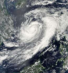
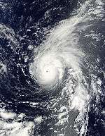
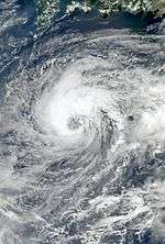
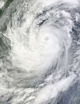
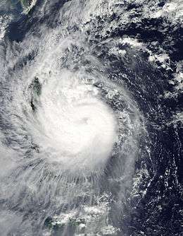
Typhoon Choi-wan formed as weak tropical disturbance early on September 11, 2009, about 1,100 kilometers (680 mi) to the east of Guam.[159] During that day the disturbance rapidly developed and was designated as a tropical depression early the next day by both the JMA and the JTWC before intensifying further and being named as Tropical Storm Choi-wan on September 12.[160][161][162] During September 13, Choi-wan's rapid intensification slowed down barely intensifying into a severe tropical storm, before early the next day it was upgraded to a typhoon and rapidly intensified during the day to become a Category 4-equivalent typhoon.[160][163] Choi-wan then intensified further during September 15, as it moved through the Northern Marina Islands with the Japan Meteorological Agency reporting peak 10 minute sustained wind speeds of 195 km/h (120 mph), whilst the Joint Typhoon Warning Center reported 1-minute peak wind speeds of 260 km/h (160 mph) which made it a category 5-equivalent typhoon.[160][164][165][166]
With the help of excellent poleward outflow and high ocean heat content, Choi-wan remained at its peak intensity until early on September 17 when deep convection started to erode in the northwestern quadrant as the tropical upper tropospheric trough cell to the northwest was no longer providing good outflow.[167] Choi-wan was then downgraded to a typhoon by the JTWC as it started to undergo an eyewall replacement cycle, with the JTWC reporting a secondary peak intensity of 150 km/h, (90 mph), during the next day.[163][168] During September 19, Choi-wan rapidly weakened, as it moved into an unfavorable environment with higher amounts of vertical wind shear, causing the storm's deep convection to erode. As a result of this and dry latitude air wrapping into the low-level circulation center, the JTWC decided to downgrade Choi-wan to an extratropical system and issued their final advisory early the next day on September 20, before the JMA followed suit later that day.[160][169] The JMA then reported that the extratropical low had dissipated completely, early on September 21.[160]
Despite the intensity of Choi-wan when it passed over the Northern Marina Islands, there was no casualties reported.[170] It was determined afterwards by the US Navy that the whole island of Alamagan was uninhabitable, with all but one of the structures, a facility for laboratory and research, completely destroyed and most of the islands' trees downed.[171] As a result, it was determined that all of the residents of Alamagan and Agrihan needed to be completely evacuated to Saipan.[172]
Typhoon Koppu (Lando)
| Typhoon (JMA) | |||
|---|---|---|---|
| Category 1 typhoon (SSHWS) | |||
| |||
| Duration | September 12 – September 16 | ||
| Peak intensity | 120 km/h (75 mph) (10-min) 975 hPa (mbar) | ||
On September 9, an area of convectional cloudiness associated with the monsoon trough formed 370 km (230 mi) to the northwest of Palau.[173] Satellite imagery showed that a consolidating Low Level Circulation Centre (LLCC) with convection had started to develop and was wrapping toward the center. On September 11, the LLCC started to show improvement and was under moderate vertical shear with good westward outflow, but the JMA still upgraded the system to a minor tropical depression.[174] Early of September 12, PAGASA upgraded the system in their responsibility and assigned its local name, Nando. At 1500 UTC, PAGASA reported that the depression made its landfall over northern Palanan, Isabela of the Philippines. However both JMA and JTWC reported that the depression did not make landfall but only crossed the Luzon straight. Early of the next day, JTWC upgraded the system into a tropical depression. Early of September 13, both JMA and JTWC upgraded the system as a tropical storm and assigned its international name, Koppu. In the afternoon, JMA reported that Koppu intensified into a severe tropical storm. On the 14th, the JMA reported that Koppu had intensified to a minimal typhoon, but the JTWC still kept Koppu as a tropical storm for the next few hours but later acknowledging the intensification and upgraded Koppu to a minimal typhoon. But the JTWC issued their final advisory early on September 15, as Koppu was moving over land, and was expected to dissipate quickly.
In Luzon, a 48-hour rainfall was experienced. In Visayas and Mindanao, a 24-hour rainfall was also experienced due to Nando's enhancing southwest monsoon. About 10 provinces were raised in signal warning no.1 from September 12 – September 13. Nando had triggered landslides resulting road closures and evacuations of some residents in Kalinga province. The storm then caused major flood in Luoding, People's Republic of China.[175]
Tropical Depression
| Tropical depression (JMA) | |||
|---|---|---|---|
| |||
| Duration | September 23 – September 26 | ||
| Peak intensity | 45 km/h (30 mph) (10-min) 1006 hPa (mbar) | ||

Early on September 23, the JMA reported that a Tropical Depression had formed about 1,145 km (711 mi) to the southeast of Tokyo, Japan.[176] During that day the depression moved towards the northwest before the JTWC reported early the next morning that the depression was a vertically stacked upper-level low with a closed circulation which was transitioning into a tropical system with a warm core.[177][178][179][180] However, as the system lacked any central convection and upper-level conditions deteriorated as a longwave trough passed by the system it was reported as dissipated early on September 25 by the JTWC, however the JMA continued to monitor the system until early the next day before issuing their final advisory on the depression.[181][182][183]
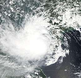
Typhoon Ketsana (Ondoy)
| Typhoon (JMA) | |||
|---|---|---|---|
| Category 2 typhoon (SSHWS) | |||
| |||
| Duration | September 23 – September 30 | ||
| Peak intensity | 150 km/h (90 mph) (10-min) 960 hPa (mbar) | ||

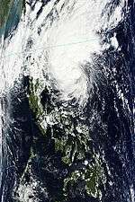
On September 22, an area of convection associated with the monsoon trough had formed about 720 km (450 mi), to the east of Manila, Philippines. Satellite imagery showed deep convection starting to consolidate about an LLCC. In the afternoon of the next day, the system started showing good outflow in LLCC and was moving through moderate vertical shear whilst the JMA upgraded the system to a tropical depression. On the evening of the same day, the JMA reported that the depression weakened into an area of low pressure. In the afternoon of September 24, the JMA reported that the system was organizing again and was upgraded to a tropical depression again, while the PAGASA also upgraded the system to a tropical depression and assigned it the local name Ondoy. On the same day, the JTWC also issued a TCFA on the system. Early the next day, the JTWC upgraded the system to a tropical depression again. In the evening, the PAGASA reported that Ondoy intensified into a tropical storm. Early on September 26, the JTWC upgraded the depression to a tropical storm as well. At the same time, JMA also upgraded it as a tropical storm and assigned it the international designated name Ketsana.
In the Philippines, the whole archipelago experienced a torrential rain starting on September 23. more than 30 areas in Luzon, including Metro Manila, were placed under storm alerts as tropical storm "Ondoy" accelerated further and moved closer to Central Luzon. On Bicol region, ferry passengers were suspended during September 25 through the next day due to high waves and heavy rains that were brought by Ketsana into the region affecting about 2000 people. In the Manila International Airport, 13 flights were canceled due to Ketsana making landfall. Some universities in Manila suspended their classes due to severe flooding in some areas and heavy rainfall.
In addition, the PAGASA also advised residents living in low-lying areas and near mountain slopes in areas affected by the Southwest Monsoon and those under signals #1 and #2 (see below) are alerted against possible flashfloods and landslides. Also, PAGASA has alerted the National Disaster Coordinating Council (NDCC) for possible flashfloods and landslides in the affected areas, particularly in Laguna, Quezon, Zambales, Pampanga and Bataan provinces. Philippine Coast Guard commandant Admiral Wilfredo Tamayo also reminded owners of seacraft of a guideline barring travel for seacraft weighing 1,000 tons or less.
In Quezon City at the PAGASA Science Garden in NCR or Manila, torrential rains and 24‑hour Rainfall amounted to 455mm the highest rainfall ever recorded in Metro Manila and belongs to the top 20 most rainiest typhoons to strike the Philippines. The amount of rainfall was 341.3mm in just 6 hours from 8AM to 2PM on the 26th of September and an additional 83mm fell for another 3 hours amounting to 424mm in about 9 Hours and the remaining 31mm was light rain showers during the night before the epic flood and the evening of the 26th of September and 111mm fell on 25 September. Bulacan also experienced an unusually high rainfall amount leading to the widespread and massive flooding in the province and overflowing of the Angat dam and opening of the floodgates at about 10:45am.
A total of 25 provinces and Metro Manila were placed under state of calamity, with Metro Manila experiencing a record amount of rainfall in 42 years, with rain falling between 8:00 a.m. and 2:00 p.m. of September 26 pegged at 341mm, over the record established in June 1967 at 334mm.[184]
Tropical Depression 18W
| Tropical depression (JMA) | |||
|---|---|---|---|
| Tropical depression (SSHWS) | |||
| |||
| Duration | September 26 – September 30 | ||
| Peak intensity | 55 km/h (35 mph) (10-min) 1000 hPa (mbar) | ||
The JTWC reported on September 24 that an area of convection had persisted about 725 km (450 mi) to the northeast of Pohnpei.[185] Deep convection had started to consolidate and wrap around the low-level circulation centre.[185] By September 26, the system had developed strong outflow and was intensifying with the JMA reporting later that day that it had become a tropical depression however the JTWC did not follow suit until early the next day when they assigned the designation of 18W to the depression.[186][187][188] During the next couple of days very little intensification took place as convection barely deepened around the low-level circulation center and in fact weakened due to the precursor system to Typhoon Parma was developing to the southeast of 18W. During September 29, both the JMA and the JTWC reported peak windspeeds of 55 km/h (35 mph).[189] As 18W approached Guam, the system became severely disrupted after interaction with what were to become Typhoons Melor and Parma.[190] As it passed near the island, the storm rapidly dissipated, first weakening to a depression and then as it lost its low-level circulation centre it was no longer considered a tropical cyclone and thus the final warnings from the JTWC and the JMA were issued.[191][192]
Despite a state of emergency being declared by the Governor of Guam before the depression affected Guam on September 29, it had very little impact on Guam.[193][194] With only increased winds and moderate rainfall reported. All flights in and out of Guam were cancelled until the storm had passed.[193][194] Five ships and a submarine from the United States Navy moved out to sea to avoid the storm; however, one submarine was unable to leave and remained at port during the storm.[195]
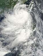
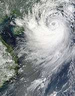
Typhoon Parma (Pepeng)
| Typhoon (JMA) | |||
|---|---|---|---|
| Category 4 super typhoon (SSHWS) | |||
| |||
| Duration | September 27 – October 14 | ||
| Peak intensity | 185 km/h (115 mph) (10-min) 930 hPa (mbar) | ||

Early on September 25, an area of convectional cloudiness associated with the monsoon through formed 410 km (250 mi) to the southeast of Palau. Satellite imagery showed a consolidating Low Level Circulation Centre. On September 27, the system began improving and showing a partial LLCC due to favorable conditions and was also located under moderate vertical wind shear, whilst the JMA upgraded the system into a tropical depression. On the evening of that day, the JTWC issued a Tropical Cyclone Formation Alert. On the next day, JMA reported that the depression had intensified into a tropical storm, submitting its international designated name, Parma. Also, on September 28, JTWC upgraded it to a tropical depression.
On the next day, JTWC again upgraded the depression into a tropical storm. And, by early September 30, due to the storm moving through warm water temperatures, the JTWC and JMA upgraded it to a Category 1 typhoon. Satellite imagery also began showing that an eye wall structure had formed. Intensification continued into the morning of the next day, reaching Category 3 status. Then, after four hours, Parma rapidly strengthened to a Category 4 super typhoon, reaching its peak strength. Different weather bureaus forecasted that Parma would intensify into a Category 5 super typhoon, however, it weakened in the afternoon of October 1 as the eye of Parma began to degrade due to its movement into unfavorable conditions. Parma continued to slightly weaken while moving through the area of Cagayan, then by midday of October 3, it was downgraded into a Category 3-equivalent typhoon.
Before it made landfall over northern Cagayan at 3:00 pm PST (07:00 UTC), it weakened into a Category 2 typhoon. Parma crossed northern Luzon over 12 hours, during which the typhoon weakened into a category 1 equivalent typhoon. PAGASA reported that the typhoon was moving almost stationary in their area of responsibility due to interaction with Typhoon Melor and a ridge of high-pressure area over mainland China. At the same time, JTWC downgraded Parma into a tropical storm while the JMA downgraded it into a severe tropical storm. Early the next day, satellite imagery revealed that Parma had an eye center but no convectional cloudiness due to high pressure. Intensification was unlikely because of unfavorable environment conditions and interaction with Typhoon Melor.
On October 6, at 11:00 pm PST (15:00 UTC), Parma made its second landfall over Ilocos Norte as it noved to the Southeast. In the afternoon of the next day, PAGASA reported that Parma weakened into a tropical depression near the Isabela area, while both JMA and JTWC still classified Parma as a tropical storm. In the morning of October 8, it emerged back into waters near Isabela. After four hours, Parma made its third landfall in Cagayan. The next day, Parma crossed Northern Luzon for the third time. Then by the afternoon of that day, Parma exited La Union and emerged back into the South China Sea. As it moved out into the Philippine area of responsibility, then PAGASA issued their final warning on Parma.
On October 10, both JMA and JTWC reported that Parma reintensified into a tropical storm while it was over the South China sea. Intensification was almost difficult due to moderate vertical wind shear.
Then by late of October 12, it made its fourth landfall over Hainan Island in China.[196] Early on October 14, Parma was downgraded by JMA to a tropical depression because there was a lack of convection. Then by the afternoon of that day, it made its fifth landfall over the coastline of Vietnam. In the evening, JMA reported that Parma weakened into an area of low pressure, becoming the agency issues their final advisory. However, JTWC still considered Parma as a tropical storm.
The names Parma and Pepeng were retired at the end of the season.
At least 500 people were killed by Parma.
Typhoon Melor (Quedan)
| Typhoon (JMA) | |||
|---|---|---|---|
| Category 5 super typhoon (SSHWS) | |||
| |||
| Duration | September 29 – October 8 | ||
| Peak intensity | 205 km/h (125 mph) (10-min) 910 hPa (mbar) | ||
On September 28, an area of convectional cloudiness formed 370 km (230 mi) to the northeast of Pohnpei. Satellite imagery showed a Low Level Circulation Centre had begun to form. On the evening of September 28, due to a TUTT that was providing good outflow for the system and low-level vertical wind shear with a favorable environment, the JTWC issued a Tropical Cyclone Formation Alert. Early on September 29, both JMA and JTWC upgraded the system into a tropical depression. Early on September 30, JMA reported that the depression had intensified into a tropical storm and assigned its international designated name, Melor. At the same time JTWC also classified the depression as a tropical storm. Early on October 1, Melor intensified further from a severe tropical storm into a typhoon. Intensification continued, and by the afternoon of the same day the JTWC reported that Melor had intensified into a Category 1-equivalent typhoon. In just four hours, it intensified rapidly to a Category 3-equivalent typhoon, and continued to track towards northeast Luzon. Early on October 2, it strengthened to a Category 4-equivalent typhoon. After levelling out in intensity, it strengthened again on October 3. Early October 4, JTWC reported that Melor had intensified to a Category-5 equivalent super typhoon, with JMA reporting a central pressure of 910 hPa and winds of 205 km/h. On October 5, PAGASA allocated the name Quedan to the typhoon as the storm moved into Philippine's area of responsibility. It interacted with Typhoon Parma in Parma's second landfall in the Philippines. By the midday of October 8, Melor made landfall on Japan. After landfall, JMA downgraded Melor into a severe tropical storm, while the JTWC downgraded it into an extratropical storm. Late on October 11, the extratropical remnants of Typhoon Melor were completely absorbed by a newly formed extratropical storm to the north, near Alaska. The new extratropical storm then strengthened into a powerful storm, which then began to impact the west coast of the United States, late on October 11, near midnight.[197]
Tropical Storm Nepartak
| Tropical storm (JMA) | |||
|---|---|---|---|
| Tropical storm (SSHWS) | |||
| |||
| Duration | October 8 – October 13 | ||
| Peak intensity | 85 km/h (50 mph) (10-min) 992 hPa (mbar) | ||
On October 6, an area of convectional cloudiness associated with the monsoon trough formed 500 km (310 mi) to the southwest of Saipan. Satellite imagery showed a consolidating Low Level Circulation Center with formative convective banding and deep convection over the northern semicircle. During in the morning of October 8, the system started to move northwest and its LLCC rapidly became well defined due to favorable conditions. The JMA then upgraded it to a tropical depression, and the JTWC issued a TCFA on the system, as it had started to become better defined. Then in the evening of that day, it was upgraded into a tropical depression by the JTWC. On October 9, the JMA upgraded it to a tropical storm and assigned its international name Nepartak. After the JMA upgraded it to a tropical storm, it slowly intensified to a peak intensity of 50 mph (85 km/h), but dissipated on October 14, because the polar jet stream had torn apart the storm.
Typhoon Lupit (Ramil)
| Typhoon (JMA) | |||
|---|---|---|---|
| Category 5 super typhoon (SSHWS) | |||
| |||
| Duration | October 14 – October 27 | ||
| Peak intensity | 175 km/h (110 mph) (10-min) 930 hPa (mbar) | ||

Early on October 13, the JTWC reported that an area of disorganized deep convection had persisted about 1,870 km (1,160 mi) to the southeast of Hagåtña, Guam.[198] The convection had a broad circulation center that was beginning to consolidate in an area of low vertical windshear and favorable sea surface temperatures.[198] Later that day, as the low-level circulation center had consolidated further, the JTWC released a tropical cyclone formation alert before early the next day both the JMA and the JTWC initiated advisories on the system as it had intensified into Tropical Depression 22W.[199][200][201] During that day the depressions low-level circulation center continued to organize with deep convective bands starting to wrap into the center.[202]
Early on October 13, the JTWC reported that an area of convection had persisted about 380 nmi (700 km) to the northwest of Kwajalein. The convection was disorganised but was starting to consolidate around a broad low-level circulation center within a favourable environment to develop further with good vertical windshear and favourable sea surface temperatures. The disturbance rapidly developed throughout that day with a Tropical Cyclone Formation Alert issued later that day by the JTWC before advisories were initiated early the next day by the JMA and the JTWC who designated it as Tropical Depression 22W before the JTWC reported that the depression had intensified into a weak tropical storm.[203] On October 15, JMA upgraded it to a Tropical Storm with the name Lupit. On the afternoon of next day, JTWC reported that Lupit strengthened into a Category 1 typhoon. That evening, PAGASA started issuing warnings on Lupit as it entered into their area of responsibility and assigned its local name, Ramil. At the same time JMA also upgraded Lupit into a typhoon. Intensification continued due to favorable conditions and hot water conditions, then by October 17, it rapidly intensified into a Category 3-equivalent typhoon. In the morning of the next day, it strengthened into a Category 4 typhoon, then strengthened further to Super Typhoon classification. On October 20, Lupit weakened to a minimal typhoon. By the 24th, dry air entrainment and an unfavorable environment had weakened Lupit further to a strong tropical storm, and caused the storm to change track from its westward drift to accelerate northeastward. Later that day, JTWC and PAGASA issued their final warning as Lupit was beginning extratropical transition. However, the JMA continued to issue warnings on Lupit until early on October 27.[204]
Tropical Depression
| Tropical depression (JMA) | |||
|---|---|---|---|
| |||
| Duration | October 16 – October 20 | ||
| Peak intensity | 45 km/h (30 mph) (10-min) 1002 hPa (mbar) | ||
Late on October 15, the JTWC reported that an area of convection had persisted about 780 km (480 mi) to the southeast of Hue, Vietnam.[205] Convection was forming and wrapping into the low-level circulation center and was moving into a favorable environment to develop with low vertical windshear and warm sea surface temperatures.[205] It was then designated as a Tropical Depression by the JMA early the next morning as the low-level circulation center was becoming exposed due to the high amounts of vertical windshear.[206][207] A tropical cyclone formation alert was issued early on October 17 by the JTWC as the vertical windshear decreased, despite the low-level circulation center being fully exposed.[208] The depression remained weak with the tropical cyclone formation alert being canceled during October 19 before the depression dissipated on October 20.[209][210]
Typhoon Mirinae (Santi)
| Typhoon (JMA) | |||
|---|---|---|---|
| Category 2 typhoon (SSHWS) | |||
| |||
| Duration | October 25 – November 3 | ||
| Peak intensity | 150 km/h (90 mph) (10-min) 955 hPa (mbar) | ||
JMA upgraded a Tropical Depression to Tropical Storm Mirinae on October 27,[211] and it rapidly strengthened to a Typhoon, to a peak of 105-110 mph. It did not strengthen much further, due to wind shear and its fast movement. PAGASA allocated the name Santi to the system the next day, as the storm had entered their area of responsibility.[212] Then Mirinae crossed the Philippines, causing it to rapidly deorganize and was downgraded from a Category 2 Typhoon, to a tropical storm in one advisory.[213][214] It then crossed into the South China Sea, and slowly, but steadily strengthened until it was very close to Vietnam.[215] Where it intensified to a Typhoon again. It made landfall and rapidly weakened.[216]
Mirinae's main effect in the Philippines is the strong winds it brings. From the night of October 30 until the next day, Southern Luzon, including Metro Manila, experienced lashing winds from the typhoon, where in Manila, minimal tropical storm force winds were at 39 m/h with gusts of 56 m/h at 6 a.m. local time, thus downing trees and made significant damage to several infrastructures. During Mirinae's passage in the Philippines, rainfall amounts from the typhoon were less than six inches recorded. Casualties from Mirinae both in the Philippines and Vietnam reached 162, with cost of damage amounting to $295 million (2009 USD).
Tropical Depression 24W (Tino)
| Tropical depression (JMA) | |||
|---|---|---|---|
| Tropical depression (SSHWS) | |||
| |||
| Duration | November 1 – November 3 | ||
| Peak intensity | 55 km/h (35 mph) (10-min) 1006 hPa (mbar) | ||

Late on October 31, the JTWC reported that a tropical disturbance had formed within an area of moderate vertical windshear about 1400 km, (870 mi), to the east of Manila, Philippines.[217][218] Deep convection had started to form over a low-level circulation center.[218] The JMA then reported early the next day that the disturbance had intensified into a weak tropical depression.[219] However at this time the JTWC did not upgrade the disturbance to a tropical depression, instead issuing a tropical cyclone formation alert later that day as the depressions poleward outflow improved.[220] Early on November 2, PAGASA named the depression as Tino as it was now located about 540 km (340 mi), to the northeast of Manila. Later that day the JTWC designated the depression as 24W, despite the system now encountering unfavorable levels of vertical windshear which made the low-level circulation center become fully exposed with no deep convection existing near the center. As a result of this early on November 3, the JMA, the JTWC and PAGASA all issued their final advisories.[221][222][223]
Tropical Depression 25W
| Tropical depression (JMA) | |||
|---|---|---|---|
| Tropical storm (SSHWS) | |||
| |||
| Duration | November 7 – November 10 | ||
| Peak intensity | 55 km/h (35 mph) (10-min) 1000 hPa (mbar) | ||
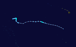
.JPG)

An area of low-pressure formed near the International Dateline on November 1. Early on November 3, the JTWC reported that an area of convection had persisted in a monsoon trough about 440 nmi (810 km) to the southeast of Pohnpei. The convection was poorly organized and was located in a monsoon trough amidst a weak and elongated circulation with weak mid-level turning. However environmental conditions were not favourable for the disturbance to develop as it was located in an area of moderate vertical windshear. Over the next few days the disturbances gradually developed a low-level circulation center and as a result was designated as a tropical depression early on November 7 by both the JMA and the JTWC.
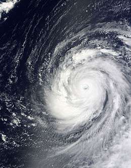
Typhoon Nida (Vinta)
| Typhoon (JMA) | |||
|---|---|---|---|
| Category 5 super typhoon (SSHWS) | |||
| |||
| Duration | November 21 – December 3 | ||
| Peak intensity | 215 km/h (130 mph) (10-min) 905 hPa (mbar) | ||


Early on November 21 the JTWC reported that an area of convection had persisted within a monsoon trough about 880 km, (545 mi) to the southeast of Guam.[224][225] At this time the system was moving around the subtropical ridge of pressure, with an anticyclone over the cyclone helping the convection to consolidate over a broad and elongated low-level circulation center which was located in an area of minimal vertical wind shear.[224][225] Later that morning a Tropical Cyclone Formation Alert was released as deep convection increased in organization with multiple bands of convection starting to wrap into the developing low-level circulation center. The system was then declared as a tropical depression by the JMA later that day before the JTWC followed suit early the next day, who assigned the designation of 26W to the depression.[226][227] On November 23, the JTWC upgraded the system to a tropical storm,[228] and JMA followed suit allocating the name Nida.[229] Later the next day, JTWC reported that Nida rapidly intensified into the equivalent of a category 1 typhoon. The next day JMA upgraded Nida to a Severe Tropical Storm[230] Intensification was anticipated until in the afternoon of November 25, then JTWC reported that Nida intensified from category 2 to a category 4 super typhoon equivalent. While JMA also upgraded it to typhoon status. At the same time an eye wall structure had formed. During the evening of November 25, Nida further intensified into an extremely intense Category 5 equivalent super typhoon, according to the JTWC, attaining winds of 285 km/h (180 mph) as it moved north west past Guam. Nida became the first storm of this intensity in the basin in terms of 10-minute winds (JMA) since Typhoon Jangmi in 2008. Additionally, the JMA reported that the barometric pressure had decreased to 905 mbar, ranking Nida as the strongest storm to form during 2009 worldwide, only slightly eclipsing Hurricane Rick's intensity. Later, Nida was downgraded to a category 4 equivalent, due to an eyewall replacement cycle, but shortly regained strength, and on November 28, Nida re-intensified to a Category 5 typhoon. It later stalled and remained quasi-stationary for some time while briefly expanding tremendously in size, then gradually weakening and shrinking into a Category 1 typhoon by November 30. While the typhoon weakened, it created a large gap in the Subtropical Ridge and sent moisture into the subtropical jet, where intense storms formed in the North Pacific. On December 1, Nida weakened to a JMA Severe Tropical storm, with top winds weakening to 60 knots (110 km/h) as Nida remained nearly stationary. By December 2, Nida began to move northward slowly, while weakening further to JMA Tropical Storm status. On December 3, Nida weakened into a PAGASA tropical depression and on the same day JTWC issued a Final Warning. However, on December 4, part of its remnants were absorbed into the Jet Stream, and the other part of the main convection remained in position to merge with Tropical Depression 28W. And thus, the remnants of Nida dissipated completely on December 4. Nida was one of the most intense cyclones ever to develop in the month of November.
Tropical Depression 27W (Urduja)
| Tropical depression (JMA) | |||
|---|---|---|---|
| Tropical depression (SSHWS) | |||
| |||
| Duration | November 23 – November 25 | ||
| Peak intensity | 55 km/h (35 mph) (10-min) 1002 hPa (mbar) | ||

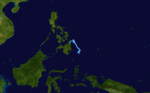
On November 23, PAGASA announced that a low-pressure area east of Mindanao had developed into a Tropical Depression and had been named "Urduja". The same day JTWC designated the tropical depression as 27W. Early Of November 25, the depression has weakened into an area of low pressure. The remnants of Urduja were absorbed into Typhoon Nida during November 25 and 26. In Eastern Visayas, 1, 519 passengers were stranded, 719 in Western Visayas, 399 in Bicol and 185 in Southern Luzon due to Urduja.[231] In all, four people were killed by Urduja, three due to a landslide and one from electrocution.[232]
Tropical Depression
| Tropical depression (JMA) | |||
|---|---|---|---|
| |||
| Duration | November 24 – November 26 | ||
| Peak intensity | 55 km/h (35 mph) (10-min) 1006 hPa (mbar) | ||
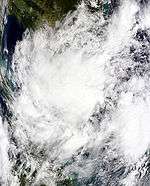

On November 22, the JTWC reported that an area of deep convection had persisted about 530 km (330 mi) to the northeast of Singapore.[233] Deep convection was flaring over a loosely defined low-level circulation center however levels of vertical wind shear were assessed to be unfavorable for development.[233] Early the next day, as the low-level circulation center was improving very quickly in an area of vertical wind shear, a tropical cyclone formation alert was then released by the JTWC, before early on November 24; the JMA reported that the disturbance had become a tropical depression.[234][235] However the JTWC reported early the next day the convection had become disorganized as the environment around the depression became less favorable, with increasing vertical wind shear. The JMA then downgraded the depression to a low-pressure area early on November 26 before it dissipated later that day.[236][237][238][239]
Tropical Depression 28W
| Tropical depression (JMA) | |||
|---|---|---|---|
| Tropical storm (SSHWS) | |||
| |||
| Duration | December 3 – December 4 | ||
| Peak intensity | 45 km/h (30 mph) (10-min) 1000 hPa (mbar) | ||
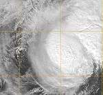

On November 29 the JTWC reported that an area of unorganized deep convection had persisted about 1,300 km (810 mi) to the north of Honiara, in the Solomon Islands.[240] Deep convection was slowly consolidating around a poorly defined low-level circulation centre, in an area of moderate to high vertical wind shear.[240] Over the next couple of days the moderate to high vertical wind shear prevented the disturbance's low-level circulation centre from consolidating further.[241][242] On December 2, the JTWC issued a TCFA as the disturbance moved close to the upper-level ridge axis which was providing an area of low vertical wind shear and gave the system a good chance of development within 12–24 hours.[243][244] During the next day, the JMA reported that the disturbance had intensified into a tropical depression before the JTWC cancelled the TCFA and downgraded the depression's chance of becoming a significant tropical cyclone within 24 hours to poor, as the low-level circulation center had become elongated and exposed whilst deep convection had become poorly organized and displaced.[245][246] As a consequence of the depression moving into an area of higher vertical wind shear, deep convection had become sheared to the north and northwest of the centre.[246] Throughout December 4, the JTWC assessed the depression's chances of becoming a significant tropical cyclone within 24 hours as poor.[247][248] However early the next day the JTWC issued their first advisory on the depression, as they reported it had become a significant tropical cyclone and designated it as Tropical Storm 28W as deep convection had been sustained near the low-level circulation center, despite vertical wind shear in excess of 30 knots (55 km/h, 35 mph).[249] The JTWC also issued their final warning at the same time as the depression was beginning to go through an extra tropical transition with dry air entering the cyclone and breaking down the storms warm core as it moved over an area of unfavourable vertical wind shear and sea surface temperatures of less than 26 °C (80 °F).[249] The JMA then downgraded the tropical depression to an extratropical low, later that day.[250][251]
Tropical Depression
| Tropical depression (JMA) | |||
|---|---|---|---|
| |||
| Duration | December 8 – December 8 | ||
| Peak intensity | 45 km/h (30 mph) (10-min) 1008 hPa (mbar) | ||
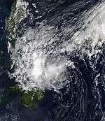
Late on December 7 the JTWC reported that an area of convection had been building around a rapidly developing low-level circulation center about 965 km (600 mi) to the southeast of Manila, Philippines.[252] The low-level circulation center had rapidly developed from the southwestern extension of a shear-line.[252] As a result of this the JTWC issued a tropical cyclone formation alert whilst the JMA reported early the next day on December 8 that the system had become a tropical depression.[252][253] Later that day the JMA issued their final advisory on the tropical depression before the JTWC canceled the TCFA as the depression made landfall on Mindanao and became a remnant low, whilst still moving in a southwestward direction. Its remnants rapidly dissipated, due to the cold front on December 9.[254][255]
Storm names
Within the North-western Pacific Ocean, both the Japan Meteorological Agency (JMA) and the Philippine Atmospheric, Geophysical and Astronomical Services Administration assign names to tropical cyclones that develop in the Western Pacific, which can result in a tropical cyclone having two names.[256] The Japan Meteorological Agency's RSMC Tokyo — Typhoon Center assigns international names to tropical cyclones on behalf of the World Meteorological Organization's Typhoon Committee, should they be judged to have 10-minute sustained windspeeds of 65 km/h (40 mph).[257] While the Philippine Atmospheric, Geophysical and Astronomical Services Administration assigns names to tropical cyclones which move into or form as a tropical depression in their area of responsibility located between 135°E and 115°E and between 5°N-25°N even if the cyclone has had an international name assigned to it.[256] The names of significant tropical cyclones are retired, by both PAGASA and the Typhoon Committee.[257]
International names
During the season 29 named tropical cyclones developed in the Western Pacific and were named by the Japan Meteorological Agency, when it was determined that they had become tropical storms. These names were contributed to a list of a 140 names submitted by the fourteen members nations and territories of the ESCAP/WMO Typhoon Committee. The names Molave, Mujigae and Mirinae were used for the first time as it was replaced from Imbudo, Maemi and Sudal
| Kujira | Chan-hom | Linfa | Nangka | Soudelor | Molave | Goni | Morakot | Etau | Vamco | Krovanh |
| Mujigae | Choi-wan | Koppu | Ketsana | Parma | Melor | Nepartak | Lupit | Mirinae | Nida |
Philippines
| Auring | Bising | Crising | Dante | Emong |
| Feria | Gorio | Huaning | Isang | Jolina |
| Kiko | Labuyo | Maring | Nando | Ondoy |
| Pepeng | Quedan | Ramil | Santi | Tino |
| Urduja | Vinta | Wilma (unused) | Yolanda (unused) | Zoraida (unused) |
| Auxiliary list | ||||
|---|---|---|---|---|
| Alamid (unused) | Bruno (unused) | Conching (unused) | Dolor (unused) | Ernie (unused) |
| Florante (unused) | Gerardo (unused) | Hernan (unused) | Isko (unused) | Jerome (unused) |
The Philippine Atmospheric, Geophysical and Astronomical Services Administration uses its own naming scheme for tropical cyclones in their area of responsibility. PAGASA assigns names to tropical depressions that form within their area of responsibility and any tropical cyclone that might move into their area of responsibility. Should the list of names for a given year prove to be insufficient, names are taken from an auxiliary list, the first 10 of which are published each year before the season starts. The names not retired from this list were used again in the 2013 season. This is the same list used in the 2005 season, except for Urduja which replaced Undang, because the name Undang had been retired in the 1984 season. Names that were not assigned are marked in gray. The names Ramil, Santi, Tino, Urduja and Vinta were used for the first time this year.[258]
Retirement
The names Morakot, Ketsana, and Parma were retired by the ESCAP/WMO Typhoon Committee. The names Atsani, Champi, and In-fa were chosen to replace Morakot, Ketsana and Parma respectively.
The Philippine Atmospheric, Geophysical and Astronomical Services Administration (PAGASA) announced that Typhoons Ondoy and Pepeng had their names retired after they both caused over 300 deaths and 1 billion PHP worth of damage in the Philippines.[259] On June 2012 the names Odette and Paolo were chosen by PAGASA to replace Ondoy and Pepeng respectively.
Season effects
This table will list all the storms that developed in the northwestern Pacific Ocean west of the International Date Line and north of the equator during 2009. It will include their intensity, duration, name, areas affected, deaths, and damage totals. Classification and intensity values will be based on estimations conducted by the JMA. All damage figures will be in 2009 USD. Damages and deaths from a storm will include when the storm was a precursor wave or an extra tropical low.
| Name | Dates active | Peak classification | Sustained wind speeds |
Pressure | Land areas affected | Damage (USD) |
Deaths | Refs |
|---|---|---|---|---|---|---|---|---|
| Auring | January 3 – 6 | Tropical depression | 45 km/h (30 mph) | 1006 hPa (29.71 inHg) | Philippines | $498 thousand | 2 | |
| Bising | February 12 – 13 | Tropical depression | 45 km/h (30 mph) | Not specified | Philippines | None | None | |
| Crising | April 30 – May 1 | Tropical depression | 55 km/h (35 mph) | Not specified | Philippines | None | None | |
| Kujira (Dante) | May 1 – 7 | Typhoon | 155 km/h (100 mph) | 940 hPa (27.76 inHg) | Philippines, Russia | $27 million | 28 | |
| TD | May 1 – 4 | Tropical depression | 55 km/h (35 mph) | 1004 hPa (29.65 inHg) | None | None | None | |
| Chan-hom (Emong) | May 2 – 9 | typhoon | 120 km/h (75 mph) | 975 hPa (28.79 inHg) | Vietnam, Philippines | $26.1 million | 60 | |
| Linfa | June 14 – 22 | Severe tropical storm | 110 km/h (70 mph) | 975 hPa (28.79 inHg) | Philippines, Taiwan, China | $105 million | 7 | |
| Nangka (Feria) | June 22 – 27 | Tropical storm | 75 km/h (45 mph) | 994 hPa (29.35 inHg) | Philippines, China | $54 thousand | 6 | |
| Soudelor (Gorio) | July 9 – 13 | Tropical storm | 65 km/h (40 mph) | 992 hPa (29.29 inHg) | Philippines, China, Vietnam | $9 million | 19 | |
| 06W (Huaning) | July 11 – 14 | Tropical depression | 55 km/h (35 mph) | 1000 hPa (29.53 inHg) | Taiwan, China | None | None | |
| Molave (Isang) | July 14 – 19 | Typhoon | 120 km/h (75 mph) | 975 hPa (28.79 inHg) | Philippines, Taiwan, China | Moderate | 4 | |
| Goni (Jolina) | July 30 – August 9 | Tropical storm | 75 km/h (45 mph) | 988 hPa (29.17 inHg) | Philippines, China, Vietnam | Minor | 8 | |
| Morakot (Kiko) | August 2 – 11 | Typhoon | 140 km/h (85 mph) | 945 hPa (27.91 inHg) | Philippines, Japan, Taiwan, China, Korea | $6.2 billion | 789 | |
| Etau | August 8 – 14 | Tropical storm | 75 km/h (45 mph) | 992 hPa (29.29 inHg) | Japan | $87.5 million | 28 | |
| Maka | August 13 – 17 | Tropical depression | 55 km/h (30 mph) | 1006 hPa (29.71 inHg) | None | None | None | |
| Vamco | August 16 – 26 | Typhoon | 165 km/h (105 mph) | 945 hPa (27.91 inHg) | None | None | None | |
| TD | August 20 – 22 | Tropical depression | 55 km/h (35 mph) | 1002 hPa (29.59 inHg) | Japan | None | None | |
| TD | August 25 – 27 | Tropical depression | 55 km/h (35 mph) | 1004 hPa (29.65 inHg) | None | None | None | |
| Krovanh | August 28 – September 1 | Severe tropical storm | 110 km/h (70 mph) | 975 hPa (28.94 inHg) | Japan | None | None | |
| 02C | August 30 – September 2 | Tropical depression | 55 km/h (35 mph) | 1004 hPa (29.65 inHg) | None | None | None | |
| Dujuan (Labuyo) | September 1 – 10 | Severe tropical storm | 95 km/h (60 mph) | 980 hPa (29.01 inHg) | Mariana Islands | None | None | |
| TD | September 3 – 9 | Tropical depression | 45 km/h (30 mph) | 1000 hPa (29.53 inHg) | Vietnam | $2.52 million | 6 | |
| Mujigae (Maring) | September 8 – 12 | Tropical storm | 75 km/h (45 mph) | 990 hPa (29.23 inHg) | Philippines, China, Vietnam | $14.6 million | 11 | |
| Koppu (Nando) | September 12 – 16 | Typhoon | 120 km/h (75 mph) | 975 hPa (28.94 inHg) | Philippines, China | Moderate | None | |
| Choi-wan | September 12 – 20 | Typhoon | 195 km/h (120 mph) | 915 hPa (27.02 inHg) | Mariana Islands | Minor | None | |
| Tropical depression | September 23 – 26 | Tropical depression | 45 km/h (30 mph) | 1006 hPa (29.71 inHg) | Mariana Islands | Minor | None | |
| Ketsana (Ondoy) | September 23 – 30 | Typhoon | 130 km/h (80 mph) | 960 hPa (28.35 inHg) | Philippines, Vietnam, Laos, Cambodia, Thailand | $1.09 billion | 710 | |
| 18W | September 26 – 30 | Tropical depression | 55 km/h (30 mph) | 1000 hPa (27.53 inHg) | Mariana Islands, Caroline Islands | None | None | |
| Parma (Pepeng) | September 27 – October 14 | Typhoon | 185 km/h (115 mph) | 930 hPa (27.46 inHg) | Caroline Islands, Philippines, Taiwan, China, Vietnam | $617 million | 500 | |
| Melor (Quedan) | September 29 – October 8 | Typhoon | 205 km/h (125 mph) | 910 hPa (26.87 inHg) | Caroline Islands, Mariana Islands, Japan | $1.5 billion | 3 | |
| Nepartak | October 8 – October 13 | Tropical storm | 85 km/h (50 mph) | 992 hPa (29.29 inHg) | Mariana Islands | None | None | |
| Lupit (Ramil) | October 14 – 27 | Typhoon | 175 km/h (110 mph) | 930 hPa (27.46 inHg) | Caroline Islands, Philippines, Japan | Minor | None | |
| TD | October 16 – October 20 | Tropical depression | 45 km/h (30 mph) | 1002 hPa (29.59 inHg) | Vietnam, China | None | None | |
| Mirinae (Santi) | October 25 – November 3 | Typhoon | 150 km/h (90 mph) | 955 hPa (28.20 inHg) | Caroline Islands, Mariana Islands, Philippines, Vietnam, Cambodia, Laos, Thailand | $295 million | 162 | |
| 24W (Tino) | November 1 – 3 | Tropical depression | 55 km/h (35 mph) | 1006 hPa (29.71 inHg) | Philippines | None | None | |
| 25W | November 7 – 10 | Tropical depression | 55 km/h (35 mph) | 1000 hPa (29.53 inHg) | None | None | None | |
| Nida (Vinta) | November 21 – December 3 | Typhoon | 215 km/h (130 mph) | 905 hPa (26.72 inHg) | Caroline Islands, Mariana Islands | Minor | None | |
| 27W (Urduja) | November 23 – 25 | Tropical depression | 55 km/h (35 mph) | 1002 hPa (29.59 inHg) | Philippines | Minor | 4 | |
| TD | November 24 – 26 | Tropical depression | 55 km/h (35 mph) | 1006 hPa (29.71 inHg) | Malaysia, Indonesia, Thailand | None | None | |
| 28W | December 3 – 4 | Tropical depression | 45 km/h (30 mph) | 1000 hPa (29.53 inHg) | None | None | None | |
| TD | December 8 | Tropical depression | 45 km/h (30 mph) | 1008 hPa (29.77 inHg) | Philippines | None | None | |
| Season Aggregates | ||||||||
| 41 systems | January 3 – December 8 | 215 km/h (130 mph) | 905 hPa (26.72 inHg) | $9.97 billion | 2348 | |||
See also
- List of Pacific typhoon seasons
- 2009 Pacific hurricane season
- 2009 Atlantic hurricane season
- 2009 North Indian Ocean cyclone season
- South-West Indian Ocean cyclone seasons: 2008–09, 2009–10
- Australian region cyclone seasons: 2008–09, 2009–10
- South Pacific cyclone seasons: 2008–09, 2009–10
- Effects of the 2009 Pacific typhoon season in the Philippines
Notes
References
- 1 2 3 Saunders, Mark; Lea, Adam (March 16, 2009). Extended Range Forecast for Northwest Pacific Typhoon Activity in 2009 (PDF) (Report). Tropical Storm Risk Consortium. Archived (PDF) from the original on July 3, 2010. Retrieved September 11, 2013.
- 1 2 3 4 5 Saunders, Mark; Lea, Adam (May 7, 2009). May Forecast Update for Northwest Pacific Typhoon Activity in 2009 (PDF) (Report). Tropical Storm Risk Consortium. Archived (PDF) from the original on July 3, 2010. Retrieved September 11, 2013.
- 1 2 3 Saunders, Mark; Lea, Adam (July 6, 2009). July Forecast Update for Northwest Pacific Typhoon Activity in 2009 (PDF) (Report). Tropical Storm Risk Consortium. Archived (PDF) from the original on September 17, 2013. Retrieved September 17, 2013.
- 1 2 3 Saunders, Mark; Lea, Adam (August 4, 2009). August Forecast Update for Northwest Pacific Typhoon Activity in 2009 (PDF) (Report). Tropical Storm Risk Consortium. Archived (PDF) from the original on September 17, 2013. Retrieved September 17, 2013.
- 1 2 3 4 Hsu, Elizabeth (June 30, 2009). "Three to five typhoons expected to hit Taiwan this year". The China Post. Retrieved September 17, 2013.
- ↑ Dizon, Nikko (January 4, 2009). "Auring to skip Visayas". Inquirer.net. Archived from the original on September 17, 2013. Retrieved September 11, 2013.
- ↑ "Speech by Mr C Y Lam, Director of the Hong Kong Observatory March 18, 2009" (PDF). Hong Kong Observatory. March 18, 2009. Archived (PDF) from the original on September 17, 2013. Retrieved September 11, 2013.
- 1 2 April 2009 Predictions of Seasonal Tropical Cyclone Activity over the Western North Pacific (PDF) (Report). Guy Carpenter Asia-Pacific Climate Impact Center. April 20, 2009. Archived (PDF) from the original on September 17, 2013. Retrieved September 17, 2013.
- ↑ "Rainy season outlook for 2009". Vietnamese National Center for Hydro Meteorological forecasts. May 1, 2009. Archived from the original on October 15, 2009. Retrieved September 11, 2013.
- 1 2 June 2009 Predictions of Seasonal Tropical Cyclone Activity over the Western North Pacific (PDF) (Report). Guy Carpenter Asia-Pacific Climate Impact Center. June 18, 2009. Archived (PDF) from the original on September 17, 2013. Retrieved June 18, 2009.
- ↑ "CWB expects three to five typhoons to hit this year". Taipei Times. July 1, 2009. Archived from the original on July 7, 2009. Retrieved September 11, 2013.
- ↑ "2-3 cyclones to visit RP in coming weeks — PAGASA". GMA News. November 14, 2009. Archived from the original on November 23, 2009. Retrieved September 17, 2013.
- 1 2 Joint Typhoon Warning Center (2008-12-31). "Tropical Depression Auring Best Track (part 1)". United States Naval Research Laboratory. Archived from the original on January 8, 2009. Retrieved 2009-01-08.
- ↑ "Significant Tropical Weather Advisory for the Western and Southern Pacific 2009-01-01 22z". Joint Typhoon Warning Center. 2009-01-01. Archived from the original on January 2, 2009. Retrieved 2009-11-08.
- ↑ "JMA WWJP25 Advisory 2009-01-03 00z". Japan Meteorological Agency. 2009-01-03. Archived from the original on January 3, 2009. Retrieved 2009-11-08.
- ↑ "PAGASA Advisory 2009-01-03 10z". Philippine Atmospheric, Geophysical and Astronomical Services Administration. 2009-01-03. Archived from the original on January 3, 2009. Retrieved 2009-11-08.
- ↑ "Significant Tropical Weather Advisory for the Western and Southern Pacific 2009-01-05 22z". Joint Typhoon Warning Center. 2009-01-05. Archived from the original on January 5, 2009. Retrieved 2009-11-08.
- ↑ "PAGASA Advisory 2009-01-05 22z". Philippine Atmospheric, Geophysical and Astronomical Services Administration. 2009-01-05. Archived from the original on January 5, 2009. Retrieved 2009-11-08.
- ↑ "JMA Advisory 2009-01-06 00z". Japan Meteorological Agency. Archived from the original on January 6, 2009. Retrieved 2009-01-08.
- ↑ "Significant Tropical Weather Advisory for the Western and South Pacific Oceans 2009-01-06 06z". Joint Typhoon Warning Center. Archived from the original on January 7, 2009. Retrieved 2009-01-08.
- ↑ Rene Acosta (2009-01-05). "Thousands of 'Auring' victims still in evacuation centers". Business Mirror. Retrieved 2009-01-08.
- ↑ Cong B. Corrales (2009-01-07). "16 villages declared 'calamity areas'". The Sun Star. Archived from the original on November 8, 2009. Retrieved 2009-05-10.
- 1 2 "Consolidated Report on Flash Floods in Cagayan de Oro City and Gingoog City" (PDF). National Disaster Coordinating Council. 2009-01-06. Archived (PDF) from the original on November 8, 2009. Retrieved 2009-01-09.
- ↑ Government of the Philippines (2009-01-09). "PGMA orders immediate rehabilitation of flood-ravaged areas in Regions X, XIII". Reliefweb. Retrieved 2009-01-10.
- ↑ "PAGASA Advisory 2009-02-12 10z". Philippine Atmospheric, Geophysical and Astronomical Services Administration. 2009-02-12. Archived from the original on February 12, 2009. Retrieved 2009-11-09.
- ↑ "PAGASA Advisory 2009-02-12 10z". Philippine Atmospheric, Geophysical and Astronomical Services Administration. 2009-02-12. Archived from the original on February 12, 2009. Retrieved 2009-11-02.
- ↑ "PAGASA Advisory 2009-02-13 04z". Philippine Atmospheric, Geophysical and Astronomical Services Administration. 2009-02-13. Archived from the original on February 13, 2009. Retrieved 2009-11-02.
- ↑ "PAGASA Advisory 2009-02-13 10z". Philippine Atmospheric, Geophysical and Astronomical Services Administration. 2009-02-13. Archived from the original on February 13, 2009. Retrieved 2009-11-02.
- ↑ Philippine Information Agency (2009-02-14). "Bising cancels ferry trips, strands passengers in Liloan, Ormoc ports". Samar News Agency. Archived from the original on November 1, 2009. Retrieved 2009-04-17.
- ↑ Jhunnex Napallacan, Joey A. Gabieta (2009-02-14). "'Bising' strands 1,600 Cebu passengers". Philippine Daily Inquirer. Retrieved 2009-04-17.
- ↑ "Cebu Transcentral Highway impassable due to landslide". Cebu News Online. 2009-02-14. Archived from the original on November 1, 2009. Retrieved 2009-03-07.
- ↑ "Significant Tropical Weather Advisory for the Western and Southern Pacific 2009-04-29 06z". Joint Typhoon Warning Center. Archived from the original on April 29, 2009. Retrieved 2009-12-06.
- ↑ "Tropical Cyclone Formation Alert 2009-04-29 23z". Joint Typhoon Warning Center. 2009-04-29. Retrieved 2009-12-06.
- ↑ "PAGASA Advisory 2009-04-30 03z". Philippine Atmospheric, Geophysical and Astronomical Services Administration. 2009-04-30. Archived from the original on April 30, 2009. Retrieved 2009-12-06.
- ↑ "Tropical Cyclone Formation Alert Cancellation 2009-04-30". Joint Typhoon Warning Center. 2009-04-30. Archived from the original on April 30, 2009. Retrieved 2009-12-06.
- ↑ "PAGASA Tropical Cyclone Warning: 2009-05-01 21z". Philippine Atmospheric, Geophysical and Astronomical Services Administration. 2009-05-01. Archived from the original on May 2, 2009. Retrieved 2009-12-06.
- ↑ Staff Writer (2009-05-02). "'Crising' affects 500 families in Quezon, isolates Bicol towns". GMA News. Archived from the original on December 6, 2009. Retrieved 2009-12-06.
- ↑ "PAGASA Tropical Depression Dante Advisory 1". PAGASA. May 1, 2009. Archived from the original on May 1, 2009. Retrieved 2009-05-03.
- ↑ "Storm 'Dante' kills 13 in Bicol; 9 missing". Philippine Daily Inquirer. May 4, 2009. Archived from the original on 5 May 2009. Retrieved 2009-05-04.
- ↑ "Typhoon Dante's death toll rises to 27". ABS-CBN News and Current Affairs. May 12, 2009. Archived from the original on 7 May 2009. Retrieved 2009-05-06.
- ↑ http://210.185.184.53/ndccWeb/images/ndccWeb/ndcc_advisory/TD_DANTE/ndcc%20update%20sitrep14%20re%20effects%20of%20ts%20dante-06%20may%202009-6am.pdf
- 1 2 "Significant Tropical Weather Advisory: 2009-04-28 15z". Joint Typhoon Warning Center. 2009-04-28. Archived from the original on April 28, 2009. Retrieved 2009-10-21.
- ↑ "Significant Tropical Weather Advisory: 2009-05-01 06z". Joint Typhoon Warning Center. 2009-05-01. Archived from the original on May 1, 2009. Retrieved 2009-10-21.
- ↑ "JMA WWJP25 Advisory 2009-05-01 12z". Japan Meteorological Agency. 2009-05-01. Archived from the original on May 1, 2009. Retrieved 2009-10-21.
- ↑ "Tropical Cyclone Formation Alert 2009-05-02 03z". Joint Typhoon Warning Center. 2009-05-02. Archived from the original on May 2, 2009. Retrieved 2009-10-21.
- ↑ "JMA WWJP25 Advisory 2009-05-02 18z". Japan Meteorological Agency. 2009-05-02. Archived from the original on May 2, 2009. Retrieved 2009-10-21.
- 1 2 "Tropical Cyclone Formation Alert Cancellation 2009-05-02 22z". Joint Typhoon Warning Center. 2009-05-02. Archived from the original on May 3, 2009. Retrieved 2009-10-21.
- ↑ "JMA WWJP25 Advisory 2009-05-04 12z". Japan Meteorological Agency. 2009-05-04. Retrieved 2009-10-21.
- ↑ "JMA WWJP25 Advisory 2009-05-04 18z". Japan Meteorological Agency. 2009-05-04. Retrieved 2009-10-21.
- ↑ "'Emong' lashes Pangasinan; fells power lines". Philippine Daily Inquirer. May 8, 2009. Archived from the original on 10 May 2009. Retrieved 2009-05-08.
- ↑ "PAGASA Advisory 5 for Typhoon Emong (Chan-hom) on May 7, 2009.". PAGASA. Archived from the original on May 7, 2009. Retrieved 2009-05-07.
- 1 2 "Significant Tropical Weather Outlook for the Western and South Pacific Oceans 13-06-09 06z". Joint Typhoon Warning Center. 2009-06-13. Retrieved 2009-07-10.
- ↑ "JMA WWJP25 Advisory 14-06-09 06z". Japan Meteorological Agency. 2009-06-14. Retrieved 2009-06-19.
- ↑ "Tropical Cyclone Formation Alert 14-06-09". Joint Typhoon Warning Center. 2009-06-14. Retrieved 2009-06-22.
- ↑ "JMA WWJP25 Advisory 14-06-09 18z". Japan Meteorological Agency. 2009-06-14. Retrieved 2009-06-22.
- ↑ "Tropical Cyclone Formation Alert: Cancellation". Joint Typhoon Warning Center. 2009-06-14. Retrieved 2009-06-22.
- ↑ "Significant Tropical Weather Outlook for the Western and South Pacific Oceans 16-06-09 22z". Joint Typhoon Warning Center. 2009-06-16. Retrieved 2009-06-22.
- ↑ "Tropical Cyclone Formation Alert". Joint Typhoon Warning Center. 2009-06-17. Retrieved 2009-06-22.
- ↑ "JMA WWJP25 Advisory 17-06-09 06z". Japan Meteorological Agency. 2009-06-17. Retrieved 2009-06-22.
- ↑ "Tropical Depression 03W Advisory 17-06-09 06z". Joint Typhoon Warning Center. 2009-06-17. Retrieved 2009-06-22.
- ↑ "Tropical Storm 03W Advisory 17-06-2009 21z". Joint Typhoon Warning Center. 2009-06-17. Retrieved 2009-06-22.
- ↑ "JMA Tropical Storm Linfa Advisory 18-06-2009 06z". Japan Meteorological Agency. 2009-06-18. Retrieved 2009-06-22.
- ↑ "Prognostic Reasoning for Tropical Storm Linfa 18-06-09 15z". Joint Typhoon Warning Center. 2009-06-18. Retrieved 2009-06-24.
- ↑ "JMA Tropical Storm Linfa Advisory 19-06-2009 12z". Japan Meteorological Agency. 2009-06-19. Retrieved 2009-06-22.
- ↑ "Prognostic Reasoning for Tropical Storm Linfa 24-06-2009 15z". Joint Typhoon Warning Center. 2009-06-19. Retrieved 2009-06-24.
- ↑ "Prognostic Reasoning for Tropical Storm Linfa 20-06-2009 03z". Joint Typhoon Warning Center. 2009-06-20. Retrieved 2009-06-24.
- ↑ "JTWC Advisory Typhoon 03W (Linfa) 20-06-2009". Joint Typhoon Warning Center. 2009-06-20. Retrieved 2009-06-22.
- ↑ "JMA Tropical Storm Linfa Advisory 20-06-2009 12z". Japan Meteorological Agency. 2009-06-20. Retrieved 2009-06-22.
- ↑ "Prognostic Reasoning for Typhoon Linfa 21-06-2009 03z". Joint Typhoon Warning Center. 2009-06-20. Retrieved 2009-06-24.
- ↑ "JTWC Tropical Storm 03W (Linfa) Advisory 21-06-2009 09z". Joint Typhoon Warning Center. 2009-06-21. Retrieved 2009-06-22.
- ↑ Staff Writer (2009-06-22). "Tropical storm Linfa hits Chinese mainland". China Central Television. Archived from the original on 24 June 2009. Retrieved 2009-06-22.
- ↑ "Prognostic Reasoning for Tropical Depression Linfa 22-06-2009 03z". Joint Typhoon Warning Center. 2009-06-21. Retrieved 2009-06-24.
- ↑ "JMA Tropical Storm Linfa Advisory 22-06-2009 06z". Japan Meteorological Agency. 2009-06-22. Retrieved 2009-06-22.
- ↑ "Tropical Depression 03W (Linfa) Advisory 22-06-09 15z". Joint Typhoon Warning Center. 2009-06-22. Retrieved 2009-06-24.
- ↑ "Significant Tropical Weather Advisory for the Western and South Pacific Oceans 22-06-09 20z". Joint Typhoon Warning Center. Archived from the original on January 4, 2009. Retrieved June 22, 2009.
- ↑ "Significant Tropical Weather Advisory for the Western and Southern Pacific Oceans 02-05-09 06z". Joint Typhoon Warning Center. 2009-05-22. Archived from the original on May 2, 2009. Retrieved 2009-05-22.
- ↑ "Tropical Cyclone Formation Alert 22-05-09 23z". Joint Typhoon Warning Center. 2009-05-22. Archived from the original on May 2, 2009. Retrieved 2009-05-22.
- ↑ "JMA Advisory 22-06-09 00z". Japan Meteorological Agency. Archived from the original on January 3, 2009. Retrieved June 22, 2009.
- ↑ Staff Writer (June 23, 2009). "Signal No.1 up over Metro Manila as Feria slams into Borongan, E. Samar". GMA News. Archived from the original on 25 June 2009. Retrieved June 23, 2009.
- ↑ Jeannette Andrade (June 23, 2009). "Fallen tree damages 3 cars at DoJ". Inquirer. Archived from the original on 25 June 2009. Retrieved June 23, 2009.
- ↑ Sarita Kare (June 23, 2009). "Hailstorm, tornado hit Batangas towns". ABS-CBN Southern Tagalog. Archived from the original on 26 June 2009. Retrieved June 23, 2009.
- ↑ "NDCC: 1 dead, 7 missing as 'Feria' pounds Cebu". June 24, 2009. Archived from the original on 26 June 2009. Retrieved June 24, 2009.
- ↑ Alice Nicart (June 24, 2009). ""Feria" leaves 500 homeless; Samar PDCC activated". Daily News Reader. Archived from the original on 2009-06-24. Retrieved June 24, 2009.
- ↑ "Big waves destroy houses | 24 Oras | GMA News Online". Gmanews.tv. 2009-06-24. Retrieved 2014-02-09.
- ↑ "300 ship passengers stranded due to 'Feria' | 24 Oras | GMA News Online". Gmanews.tv. 2009-06-24. Retrieved 2014-02-09.
- ↑ "Parts of Metro Manila in deep flood | 24 Oras | GMA News Online". Gmanews.tv. 2009-06-24. Retrieved 2014-02-09.
- ↑ Staff Writer (June 24, 2009). "Pagasa: 75 kph winds won't be felt in Metro Manila; 6 dead, 11 missing". GMA News TV. Archived from the original on 27 June 2009. Retrieved June 24, 2009.
- ↑ "Significant Tropical Weather Advisory for the Western and South Pacific Oceans 2009-07-20 19z". Joint Typhoon Warning Center. 2009-07-07. Retrieved 2009-07-20.
- ↑ "Significant Tropical Weather Advisory for the Western and South Pacific Oceans 2009-07-08 06z". Joint Typhoon Warning Center. 2009-07-08. Retrieved 2009-07-20.
- ↑ "Tropical Cyclone Formation Alert 2009-07-09". Joint Typhoon Warning Center. 2009-07-09. Retrieved 2009-07-20.
- ↑ "Tropical depression "Gorio" enters RP; 9 provinces under signal No. 1". Philippine Atmospheric, Geophysical and Astronomical Services Administration. Balita. 2009-07-09. Archived from the original on October 4, 2009. Retrieved 2009-07-20.
- ↑ "JTWC Tropical Depression 05W Advisory One". Joint Typhoon Warning Center. 2009-07-09. Retrieved 2009-07-09.
- 1 2 "JMA Tropical Cyclone Best Track: Soudelor". Japan Meteorological Agency. 2009-09-02. Archived from the original on September 2, 2009. Retrieved 2009-09-02.
- ↑ Evelyn Macairan, Artemio Dumlao (2009-07-12). "New low-pressure area spotted as 'Gorio' leaves RP". Philippine Star. Retrieved 2009-07-20.
- ↑ "Tropical Storm 05W (Soudelor) Advisory Six". Joint Typhoon Warning Center. 2009-07-11. Retrieved 2009-07-20.
- ↑ Various Agencies (2009-07-11). "Tropical Cyclone Advisories for 0600 UTC on 2009-07-11". Retrieved 2009-07-20.
- ↑ "Tropical Depression Soudelor (05W) Advisory Seven". Joint Typhoon Warning Center. 2009-07-11. Retrieved 2009-07-20.
- ↑ Joint Typhoon Warning Center (2009-07-11). "Tropical Storm Soudelor (05W)". Retrieved 2009-07-20.
- ↑ "Tropical Depression Soudelor (05W) Advisory Ten". Joint Typhoon Warning Center. 2009-07-12. Retrieved 2009-07-20.
- ↑ Various Agencies (2009-07-12). "Tropical Cyclone Advisories for 0600 UTC on July 12". Retrieved 2009-07-20.
- ↑ Various Agencies (2009-07-12). "Tropical Cyclone Advisories for 1200 UTC on 2009-07-12". Retrieved 2009-07-20.
- ↑ Glenn J. Rabonza (2009-07-10). "Situation Report No. 1: Effects of Tropical Depression "Gorio"" (PDF). National Disaster Coordinating Council. Archived from the original (PDF) on May 30, 2011. Retrieved 2009-07-15.
- ↑ Dave Samuhel (2009-07-12). "Soudelor Brings Heavy Rain To China, Vietnam Sunday". Star Tribune. Archived from the original on October 4, 2009. Retrieved 2009-07-15.
- ↑ "Classes suspended in flood-hit Laoag City". ABS-CBN News. 2009-07-10. Retrieved 2009-07-15.
- ↑ Staff Writer (July 13, 2009). "Inondations dans le Sud de la Chine: 15 morts" (in French). Meteo World. Retrieved July 15, 2009.
- ↑ Staff Writer (2009-07-14). "Storm passes but new tropical depression affects coastal waters". VietNamNet Bridge. Archived from the original on 2009-07-17. Retrieved 2009-07-15.
- ↑ Staff Writer (2009-07-14). "Hanoi streets flooded for hours by storm". Thanh Nien Daily. Retrieved 2009-07-15.
- ↑ "Downpours and whirlwinds cause damage in northern region". Nhan Dan. 2009-07-14. Archived from the original on 2009-07-17. Retrieved 2009-07-15.
- ↑ Associated Press (2009-08-16). "'Isang' leaves 1 dead, 2 missing". The Filipino Star. Archived from the original on August 16, 2009. Retrieved July 17, 2009.
- 1 2 3 "Significant tropical weather advisory for the Western and the Southern Pacific Oceans". Joint Typhoon Warning Center. 2009-07-25. Retrieved 2009-07-30.
- ↑ Archived August 7, 2009, at the Wayback Machine.
- ↑ "Death toll from tropical storm Goni rises to five in south China". Xinhua via ReliefWeb. 2009-08-10. Retrieved 2009-10-02.
- ↑ "JMA WWJP25 Advisory 02-08-2009 00z". Japan Meteorological Agency. 2009-08-02. Retrieved 2009-08-02.
- 1 2 "Significant Tropical Weather Advisory 03-08-2009 00z". Joint Typhoon Warning Center. 2009-08-03. Retrieved 2009-08-03.
- ↑ "JMA WWJP25 Advisory 02-08-2009 06z". Japan Meteorological Agency. 2009-08-02. Retrieved 2009-08-02.
- ↑ "JMA WWJP25 Advisory 02-08-2009 12z". Japan Meteorological Agency. 2009-08-02. Retrieved 2009-08-02.
- ↑ "JMA WWJP25 Advisory 02-08-2009 18z". Japan Meteorological Agency. 2009-08-02. Retrieved 2009-08-02.
- ↑ "'Kiko' intensifies further, 4 areas under signal 1 | News | GMA News Online". Gmanews.tv. 2009-08-07. Retrieved 2014-02-09.
- ↑ "'Kiko' death toll rises to 10". ABS-CBN News. 2009-08-07. Retrieved 2009-12-06.
- ↑ "'Kiko' death toll rises to 10; 30K folks affected in Luzon". GMANews. 2009-08-07. Archived from the original on December 6, 2009. Retrieved 2009-12-06.
- ↑ "Landslide, floods kill 12 in RP". Sun Star. 2009-08-08. Archived from the original on December 6, 2009. Retrieved 2009-12-06.
- ↑ "Typhoon Morakot lashes Taiwan". CNN. 2009-08-07. Retrieved 2009-08-07.
- ↑ "Record rains in south — The China Post". The China Post. 2009-08-09. Archived from the original on 2009-08-11. Retrieved 2009-08-09.
- ↑ Mu Xuequan (2009-08-08). "20,000 evacuated in SE China as typhoon Morakot nears; nine fishermen missing". Xinhua. Retrieved 2009-10-21.
- ↑ "2 dead, 4 missing after typhoon slams Taiwan". CBC News. 2009-08-08. Archived from the original on 2009-08-11. Retrieved 2009-08-08.
- ↑ http://www.webcitation.org/5kELGYqwT?url=http%3A%2F%2Fweather.noaa.gov%2Fpub%2Fdata%2Fraw%2Fax%2Faxpq20.rjtd..txt
- ↑ "Tropical Cyclone Formation Alert 14-08-2009 12z". Joint Typhoon Warning Center. 2009-08-14. Archived from the original on August 14, 2009. Retrieved 2009-08-14.
- ↑ "Tropical Depression 01C (Maka) JTWC Warning 1". Joint Typhoon Warning Center. 2009-08-14. Archived from the original on August 14, 2009. Retrieved 2009-08-14.
- 1 2 "Significant Tropical Weather Advisory for the Western and Southern Pacific Oceans 2009-08-13 21z". Joint Typhoon Warning Center. 2009-08-13. Retrieved 2009-11-02.
- ↑ "Tropical Cyclone Formation Alert 2009-08-16 0600z". Joint Typhoon Warning Center. 2009-08-16. Archived from the original on August 16, 2009. Retrieved 2009-11-02.
- 1 2 3 4 5 "RSMC Tropical Cyclone Best Track: Vamco". Japan Meteorological Agency. 2009-10-08. Archived from the original on October 8, 2009. Retrieved 2009-11-02.
- 1 2 3 4 "Tropical Cyclone Vamco Running Best track Information". Joint Typhoon Warning Center. United States Naval Research Laboratory. 2009-08-13. Retrieved 2009-11-09.
- ↑ "Global Tropical Cyclone Tracks — August 2009". Gary Padgett. Australian Severe Weather. 2009-11-07. Retrieved 2009-11-09.
- ↑ "JMA WWJP25 Advisory 20-08-2009 00z". Japan Meteorological Agency. 2009-08-20. Retrieved 2009-08-20.
- 1 2 "Significant Tropical Weather Advisory for the Western and Southern Pacific 2009-08-20 06z". Joint Typhoon Warning Center. 2009-08-20. Archived from the original on August 20, 2009. Retrieved 2009-08-20.
- ↑ "JMA WWJP25 Advisory 2009-08-21 06z". Japan Meteorological Agency. 2009-08-21. Retrieved 2009-08-22.
- ↑ "JMA WWJP25 Advisory 2009-08-21 12z". Japan Meteorological Agency. 2009-08-21. Retrieved 2009-08-22.
- ↑ "JTWC Running Best Track: Tropical Depression 15". Joint Typhoon Warning Center. Naval Research Laboratory. 2009-08-19. Archived from the original on August 22, 2009. Retrieved 2009-08-22.
- ↑ "Significant Tropical Weather Advisory for the Western and Southern Pacific 2009-08-22 06z". Joint Typhoon Warning Center. 2009-08-22. Retrieved 2009-08-22.
- 1 2 3 "Significant Tropical Weather Advisory for the Western and Southern Pacific Ocean 2009-08-25 06". Joint Typhoon Warning Center. 2009-08-25. Retrieved 2009-08-26.
- ↑ "JMA WWJP25 Warning 2009-08-25 06z". Japan Meteorological Agency. 2009-08-25. Retrieved 2009-08-26.
- ↑ "Significant Tropical Weather Advisory for the Western and Southern Pacific Ocean 2009-08-26 06". Joint Typhoon Warning Center. 2009-08-26. Retrieved 2009-08-26.
- ↑ "JMA WWJP25 Warning 2009-08-26 06z". Japan Meteorological Agency. 2009-08-26. Retrieved 2009-08-26.
- ↑ "JMA WWJP25 Warning 2009-08-26 12z". Japan Meteorological Agency. 2009-08-26. Retrieved 2009-08-26.
- ↑ "JMA WWJP25 Warning 2009-08-25 18z". Japan Meteorological Agency. 2009-08-26. Retrieved 2009-08-26.
- ↑ "JMA WWJP25 Advisory 28-08-2009 00z". Japan Meteorological Agency. 2009-08-28. Retrieved 2009-08-28.
- ↑ "JMA Tropical Cyclone Advisory 2009-08-29 18z". Japan Meteorological Agency. 2009-08-29. Archived from the original on August 29, 2009. Retrieved 2009-08-30.
- ↑ "CPHC Tropical Cyclone Advisory 29-08-2009 21z CCA". Central Pacific Hurricane Center. National Oceanic and Atmospheric Administration. 2009-08-21. Retrieved 2009-08-30.
- 1 2 3 "Prognostic Reasoning for Tropical Depression 02C 2009-08-30 03z". Joint Typhoon Warning Center. 2009-08-30. Retrieved 2009-08-30.
- ↑ "JTWC Tropical Cyclone Advisory 2009-08-30 09z". Joint Typhoon Warning Center. 2009-08-30. Retrieved 2009-08-30.
- ↑ "JMA WWJP25 Advisory 01-09-2009 18z". Japan Meteorological Agency. 2009-08-01. Retrieved 2009-09-02.
- ↑ "JMA WWJP25 Advisory 02-09-2009 00z". Japan Meteorological Agency. 2009-09-02. Retrieved 2009-09-02.
- ↑ "JMA Tropical Cyclone Advisory 2009-09-01 18z". Japan Meteorological Agency. 2009-09-01. Archived from the original on August 29, 2009. Retrieved 2009-09-01.
- ↑ "JTWC Tropical Cyclone Advisory 2009-09-01 09z". Joint Typhoon Warning Center. 2009-09-01. Retrieved 2009-09-01.
- ↑ Staff Writer (September 6, 2009). "Tropical low hangs around". Thanh Nien Daily. Retrieved September 6, 2009.
- ↑ "JMA Tropical Cyclone Advisory 2009-09-08 18z". Japan Meteorological Agency. 2009-09-08. Archived from the original on August 29, 2009. Retrieved 2009-09-08.
- ↑ "JTWC Tropical Cyclone Advisory 2009-09-08 09z". Joint Typhoon Warning Center. 2009-09-08. Retrieved 2009-09-08.
- ↑ "JTWC Tropical Cyclone Advisory 2009-08-30 09z". Joint Typhoon Warning Center. 2009-09-09. Retrieved 2009-09-09.
- ↑ "Significant Tropical Weather Advisory for the Western and Southern Pacific Oceans 2009-09-11 14z". Joint Typhoon Warning Center. 2009-09-11. Retrieved 2009-09-14.
- 1 2 3 4 5 "RSMC Tropical Cyclone Best Track:Typhoon Choiwan (0914)". Japan Meteorological Agency. 2009-11-13. Archived from the original on November 13, 2009. Retrieved 2009-11-13.
- ↑ "JTWC Prognostic Reasoning 2009-09-12 03z". Joint Typhoon Warning Center. 2009-09-12. Retrieved 2009-09-14.
- ↑ "JTWC: Tropical Cyclone Advisory 2009-09-12 21z". Joint Typhoon Warning Center. 2009-09-12. Retrieved 2009-09-15.
- 1 2 "Super Typhoon 15W Choi-wan Best Track Data". Joint Typhoon Warning Center. United States Naval Research Laboratory. 2009-09-10. Retrieved 2009-09-20.
- ↑ Chan (2009-09-15). "Typhoon Choi-wan Intermediate Advisory Number 13A". National Weather Service in Tiyan, Guam. Archived from the original on September 15, 2009. Retrieved 2009-09-20.
- ↑ "JTWC:Tropical Cyclone Advisory 2009-09-15 09z". Joint Typhoon Warning Center. 2009-09-15. Retrieved 2009-09-20.
- ↑ Aaron Sheldrick (2009-09-16). "Typhoon Choi-Wan Strengthens to Category 5 in Pacific (Update3)". Bloomberg Television. Retrieved 2009-09-20.
- ↑ "JTWC Prognostic Reasoning 2009-09-17 03z". Joint Typhoon Warning Center. 2009-09-17. Retrieved 2009-09-23.
- ↑ "JTWC Tropical Cyclone Advisory 2009-09-18 09z". Joint Typhoon Warning Center. 2009-09-18. Retrieved 2009-09-23.
- ↑ "JTWC:Tropical Cyclone Advisory 2009-09-20 03z". Joint Typhoon Warning Center. 2009-09-20. Retrieved 2009-09-20.
- ↑ Ferdie de la Torre (2009-09-17). "Alamagan, Agrihan residents all safe". Saipan Tribune. Retrieved 2009-09-19.
- ↑ Staff Writer (2009-09-18). "Sablan: Navy helping CNMI in typhoon recovery". Pacific Daily News. Archived from the original on September 19, 2009. Retrieved 2009-09-19.
- ↑ Ferdie de la Torre (2009-09-19). "All residents of Alamagan, Agrihan facing evacuation". Saipan Tribune. Retrieved 2009-09-19.
- ↑ "JMA Tropical Cyclone Advisory 2009-09-11 18z". Japan Meteorological Agency. 2009-09-11. Archived from the original on August 29, 2009. Retrieved 2009-09-11.
- ↑ "Japan Meteorological Agency | Weather Maps". Archived from the original on 2009-09-16. Retrieved 2009-09-13.
- ↑ TimesofIndia.com. "TimesofIndia.com." Seven die as Typhoon Koppu hits China. Retrieved on 2009-10-09.
- ↑ "JMA WWJP25 Advisory 2009-09-23 00z". Japan Meteorological Agency. 2009-09-23. Retrieved 2009-10-16.
- ↑ "JMA WWJP25 Advisory 2009-09-23 06z". Japan Meteorological Agency. 2009-09-23. Retrieved 2009-10-16.
- ↑ "JMA WWJP25 Advisory 2009-09-23 12z". Japan Meteorological Agency. 2009-09-23. Retrieved 2009-10-16.
- ↑ "JMA WWJP25 Advisory 2009-09-23 18z". Japan Meteorological Agency. 2009-09-23. Retrieved 2009-10-16.
- ↑ "Significant Tropical Weather Advisory for the Western and Southern Pacific Ocean 2009-09-24 01z". Joint Typhoon Warning Center. 2009-09-24. Retrieved 2009-10-16.
- ↑ "Significant Tropical Weather Advisory for the Western and Southern Pacific Ocean 2009-09-24 21z". Joint Typhoon Warning Center. 2009-09-24. Retrieved 2009-10-17.
- ↑ "Significant Tropical Weather Advisory for the Western and Southern Pacific Ocean 2009-09-25 06z". Joint Typhoon Warning Center. 2009-09-25. Retrieved 2009-10-17.
- ↑ "JMA WWJP25 Advisory 2009-09-26 00z". Japan Meteorological Agency. 2009-09-23. Retrieved 2009-10-16.
- ↑ "Metro Manila, 25 provinces placed under state of calamity. Ketsana leaves Philippines with more than 300 dead". GMANews.tv. 2009-09-26. Archived from the original on 18 October 2009. Retrieved 2009-09-26.
- 1 2 "Significant Tropical Weather Advisory for the Western and South Pacific Oceans 2009-09-24 21z". Joint Typhoon Warning Center. 2009-09-24. Retrieved 2009-10-02.
- ↑ "Significant Tropical Weather Outlook for the Western and South Pacific Oceans". Joint Typhoon Warning Center. 2009-09-26. Retrieved 2009-10-02.
- ↑ "WWJP25 RJTD 260600". Japan Meteorological Agency. 2009-09-26. Retrieved 2009-10-02.
- ↑ "Tropical Depression 18W Warning 2009-09-27 06z". Joint Typhoon Warning Center. 2009-09-27. Retrieved 2009-10-02.
- ↑ "WWJP25 RJTD 281800". Japan Meteorological Agency. 2009-09-28. Retrieved 2009-10-04.
- ↑ "Tropical Storm 18W Advisory 11". Joint Typhoon Warning Center. 2009-09-29. Retrieved 2009-10-04.
- ↑ "Tropical Depression 18W warning 13". Joint Typhoon Warning Center. 2009-09-30. Retrieved 2009-10-04.
- ↑ "WWJP25 RJTD 301200". Japan Meteorological Agency. 2009-09-30. Retrieved 2009-10-04.
- 1 2 "Governor Declares State of Emergency For 18W". Pacific News Center. September 29, 2009. Retrieved 2009-10-04.
- 1 2 Kevin Kerrigan (2009-09-30). "NWS: Storm With No Name Has No Punch". Pacific News Center. Retrieved 2009-10-04.
- ↑ CNN (2009-09-30). "Navy Vessels Set Sail To Avoid Tropical Depression Near Guam". wibw. Archived from the original on October 3, 2009. Retrieved 2009-10-04.
- ↑ Xiong Tong (2009-10-12). "Tropical storm Parma lands on S China province Hainan". Xinhua. Retrieved 2009-10-12.
- ↑ "JMA BT: Melor". Japan Meteorological Agency. 2009-11-27. Archived from the original on November 27, 2009. Retrieved 2010-01-16.
- 1 2 "Significant Tropical Weather Advisory for the Western and Southern Pacific Ocean 2009-10-13 06z". Joint Typhoon Warning Center. 2009-10-13. Retrieved 2010-04-11.
- ↑ "Tropical Cyclone Formation Alert 2009-10-13 23z". Joint Typhoon Warning Center. 2009-10-13. Archived from the original on October 14, 2009. Retrieved 2010-04-11.
- ↑ "JTWC Tropical Cyclone Warning 2009-10-14 00z". Joint Typhoon Warning Center. 2009-10-14. Retrieved 2010-04-11.
- ↑ "JTWC Tropical Cyclone Best Track Analysis Super Typhoon Lupit 2009". Joint Typhoon Warning Center. 2010-02-18. Archived from the original on 4 March 2010. Retrieved 2010-04-11.
- ↑ "JTWC Tropical Cyclone Warning 2009-10-14 06z". Joint Typhoon Warning Center. 2009-10-14. Retrieved 2010-04-11.
- ↑ "JTWC Tropical Cyclone 22W Warning 05". Joint Typhoon Warning Center. 2009-10-14. Retrieved 2009-10-12.
- ↑ "JTWC Tropical Cyclone 22W Warning 44". Joint Typhoon Warning Center. 2009-10-25. Retrieved 2009-10-25.
- 1 2 "Significant Tropical Weather Advisory for the Western and Southern Pacific Ocean 2009-10-15 19z". Joint Typhoon Warning Center. 2009-10-15. Retrieved 2009-10-18.
- ↑ "JMA WWJP25 Advisory 2009-10-16 06z". Japan Meteorological Agency. 2009-10-16. Retrieved 2009-10-18.
- ↑ "Significant Tropical Weather Advisory for the Western and Southern Pacific Ocean 2009-10-16 06z". Joint Typhoon Warning Center. 2009-10-16. Retrieved 2009-10-18.
- ↑ "Tropical Cyclone Formation Alert 2009-10-17 09z". Joint Typhoon Warning Center. 2009-10-17. Archived from the original on October 17, 2009. Retrieved 2009-10-18.
- ↑ "Tropical Cyclone Formation Alert Cancellation 2009-10-19 22z". Joint Typhoon Warning Center. 2009-10-19. Retrieved 2009-10-22.
- ↑ "Significant Tropical Weather Advisory for the Western and Southern Pacific ocean 2009-10-21 06z". Joint Typhoon Warning Center. 2009-10-21. Retrieved 2009-10-22.
- ↑ "TROPICAL STORM MIRINAE STRENGTHENS, Heading Towards RP!". Retrieved October 28, 2009.
- ↑ "Typhoon Santi: Situationer and Advisories". Bayanihan Online. Retrieved October 28, 2009.
- ↑ "Typhoon "Santi" - National Capital Region - Response Agencies' Primary Areas of Responsibility, 29 October 2009". Retrieved October 29, 2009.
- ↑ "Typhoon Mirinae Forecast Track Toward Flood Plagued, Disease Infested Portion of Philippines". Retrieved October 31, 2009.
- ↑ "At least 4 dead as Typhoon Mirinae hits Vietnam". Retrieved November 3, 2009.
- ↑ "Remant of Typhoon Mirinae Moving Toward Vietnam; Leaves 14 dead, flooding in Philippines". Retrieved November 1, 2009.
- ↑ "JTWC Tropical Cyclone Best Track Analysis:TD 24W (Tino)". Joint Typhoon Warning Center. 2010-02-22. Archived from the original on 4 March 2010. Retrieved 2010-03-28.
- 1 2 "Significant Tropical Weather Advisory for the Western and Southern Pacific Oceans 2009-10-31 20z". Joint Typhoon Warning Center. 2009-10-31. Retrieved 2009-11-02.
- ↑ "JMA WWJP25 Advisory 2009-11-01 00z". Japan Meteorological Agency. 2009-11-01. Retrieved 2009-12-05.
- ↑ "Tropical Cyclone Formation Alert 2009-11-01 22z". Joint Typhoon Warning Center. 2009-11-01. Retrieved 2010-03-28.
- ↑ "Typhoon 2000 Storm Logs:Tino". Typhoon 2000. 2009-11-02. Retrieved 2010-03-28.
- ↑ "JTWC Tropical Depression 24W Advisory 1 2009-11-02 18z". Joint Typhoon Warning Center. 2009-11-02. Retrieved 2010-03-28.
- ↑ "JTWC Tropical Depression 24W Advisory 2 2009-11-03 00z". Joint Typhoon Warning Center. 2009-11-03. Retrieved 2010-03-28.
- 1 2 "Significant tropical weather advisory for the Western and South Pacific Ocean 2009-11-21 06z". Joint Typhoon Warning Center. 2009-11-21. Retrieved 2009-11-22.
- 1 2 "Tropical Cyclone Formation Alert 2009-11-21 1100z". Joint Typhoon Warning Center. 2009-11-21. Retrieved 2009-11-22.
- ↑ "JMA WWJP25 Advisory 2009-11-21 18z". Japan Meteorological Agency. 2009-11-21. Retrieved 2009-11-22.
- ↑ "Prognostic reasoning for Tropical Depression 26W". Joint Typhoon Warning Center. 2009-11-22. Retrieved 2009-11-22.
- ↑ "Prognostic reasoning for Tropical Storm 26W". Joint Typhoon Warning Center. 2009-11-23. Retrieved 2009-11-23.
- ↑ "JMA WWJP25 Advisory 2009-11-23 12z". Japan Meteorological Agency. 2009-11-23. Retrieved 2009-11-23.
- ↑ "JMA WWJP25 Advisory 2009-11-24 12z". Japan Meteorological Agency. 2009-11-24. Retrieved 2009-11-24.
- ↑ http://www.bomboradyo.com/newsdetails1.asp?ID=120108. Retrieved November 24, 2009. Missing or empty
|title=(help) - ↑ National Disaster Coordinating Council (November 26, 2009). "Situation Report No. 6 on Tropical Depression "Urduja"". ReliefWeb. Retrieved November 26, 2009.
- 1 2 "Significant tropical weather advisory for the Western and South Pacific Ocean 2009-11-22 06z". Joint Typhoon Warning Center. 2009-11-22. Retrieved 2009-11-30.
- ↑ "Tropical Cyclone Formation Alert 2009-11-23 11z". Joint Typhoon Warning Center. 2009-11-23. Retrieved 2009-11-30.
- ↑ "JMA WWJP25 Advisory 2009-11-24 06z". Japan Meteorological Agency. 2009-11-24. Retrieved 2009-11-30.
- ↑ "Significant Tropical Weather Advisory for the Western and Southern Pacific Oceans 2009-11-25 06z". Joint Typhoon Warning Center. 2009-11-25. Retrieved 2009-11-30.
- ↑ "JMA WWJP25 Advisory 2009-11-25 18z". Japan Meteorological Agency. 2009-11-25. Retrieved 2009-11-30.
- ↑ "JMA WWJP25 Advisory 2009-11-26 00z". Japan Meteorological Agency. 2009-11-26. Retrieved 2009-11-30.
- ↑ "Significant Tropical Weather Advisory for the Western and Southern Pacific Oceans 2009-11-26 06z". Joint Typhoon Warning Center. 2009-11-26. Retrieved 2009-11-30.
- 1 2 "Significant Tropical Weather Advisory for the Western and South Pacific ocean 2009-11-29 06z". Joint Typhoon Warning Center. 2009-11-29. Retrieved 2009-12-05.
- ↑ "Significant Tropical Weather Advisory for the Western and South Pacific ocean 2009-11-30 06z". Joint Typhoon Warning Center. 2009-11-30. Retrieved 2009-12-05.
- ↑ "Significant Tropical Weather Advisory for the Western and South Pacific ocean 2009-12-01 06z". Joint Typhoon Warning Center. 2009-12-01. Retrieved 2009-12-05.
- ↑ "Significant Tropical Weather Advisory for the Western and South Pacific ocean 2009-12-01 06z". Joint Typhoon Warning Center. 2009-12-01. Retrieved 2009-12-05.
- ↑ "Tropical Cyclone Formation Alert 2009-12-02 21z". Joint Typhoon Warning Center. 2009-12-02. Retrieved 2009-12-05.
- ↑ "JMA WWJP25 Advisory 2009-12-03 18z". Japan Meteorological Agency. 2009-12-03. Retrieved 2009-12-05.
- 1 2 "Tropical Cyclone Formation Alert Cancellation 2009-12-03 19z". Joint Typhoon Warning Center. 2009-12-03. Retrieved 2009-12-05.
- ↑ "Significant Tropical Weather Advisory for the Western and South Pacific ocean 2009-12-04 06z". Joint Typhoon Warning Center. 2009-12-04. Retrieved 2009-12-05.
- ↑ "Significant Tropical Weather Advisory for the Western and South Pacific ocean 2009-12-04 21z". Joint Typhoon Warning Center. 2009-12-04. Retrieved 2009-12-05.
- 1 2 "JTWC Tropical Cyclone Advisory 2009-12-05 03z". Joint Typhoon Warning Center. 2009-12-05. Retrieved 2009-12-05.
- ↑ "JMA WWJP25 Advisory 2009-12-05 06z". Japan Meteorological Agency. 2009-12-05. Retrieved 2009-12-05.
- ↑ "JMA WWJP25 Advisory 2009-12-05 12z". Japan Meteorological Agency. 2009-12-05. Retrieved 2009-12-05.
- 1 2 3 "Tropical Cyclone Formation Alert 2009-12-07 23z". Joint Typhoon Warning Center. 2009-12-07. Archived from the original on December 8, 2009. Retrieved 2009-12-09.
- ↑ "JMA WWJP25 Advisory 2009-12-08 00z". Japan Meteorological Agency. 2009-12-08. Retrieved 2009-12-09.
- ↑ "JMA WWJP25 Advisory 2009-12-08 18z". Japan Meteorological Agency. 2009-12-08. Retrieved 2009-12-09.
- ↑ "JMA WWJP25 Advisory 2009-12-09 00z". Japan Meteorological Agency. 2009-12-09. Retrieved 2009-12-09.
- 1 2 Padgett, Gary. "Monthly Tropical Cyclone Summary December 1999". Australian Severe Weather. Archived from the original on August 28, 2012. Retrieved August 28, 2012.
- 1 2 The Typhoon Committee (February 21, 2013). "Typhoon Committee Operational Manual 2013" (PDF). World Meteorological Organization. pp. 37–38. Archived (PDF) from the original on August 28, 2012.
- ↑ "The Philippine Tropical Cyclone Names". Typhoon 2000. 2008-10-30. Retrieved 2009-10-23.
- ↑ Helen Flores (2009-12-26). "FLOODING IN 2009: RP FEELS CLIMATE CHANGE". PhilStar.com. Archived from the original on December 27, 2009. Retrieved 2009-12-27.
External links
| Wikimedia Commons has media related to 2009 Pacific typhoon season. |
- Japan Meteorological Agency
- China Meteorological Agency
- Digital Typhoon
- Hong Kong Observatory
- Joint Typhoon Warning Center
- Korea Meteorological Administration
- National Weather Service Guam
- Malaysian Meteorological Department
- Philippine Atmospheric, Geophysical and Astronomical Services Administration
- Taiwan Central Weather Bureau
- TCWC Jakarta (Indonesian)
- Thai Meteorological Department (Thai)
- Typhoon2000
- Vietnam's National Hydro-Meteorological Service
Tropical cyclones of the 2009 Pacific typhoon season | |||||||||||||||||||||||||||||||||||||||||||||||||||||||||||||||||||||||||||||||||||||||||||||||||||||||||||||||||||||||||||||
|---|---|---|---|---|---|---|---|---|---|---|---|---|---|---|---|---|---|---|---|---|---|---|---|---|---|---|---|---|---|---|---|---|---|---|---|---|---|---|---|---|---|---|---|---|---|---|---|---|---|---|---|---|---|---|---|---|---|---|---|---|---|---|---|---|---|---|---|---|---|---|---|---|---|---|---|---|---|---|---|---|---|---|---|---|---|---|---|---|---|---|---|---|---|---|---|---|---|---|---|---|---|---|---|---|---|---|---|---|---|---|---|---|---|---|---|---|---|---|---|---|---|---|---|---|---|
|
| ||||||||||||||||||||||||||||||||||||||||||||||||||||||||||||||||||||||||||||||||||||||||||||||||||||||||||||||||||||||||||||
| |||||||||||||||||||||||||||||||||||||||||||||||||||||||||||||||||||||||||||||||||||||||||||||||||||||||||||||||||||||||||||||