2011 New England tornado outbreak
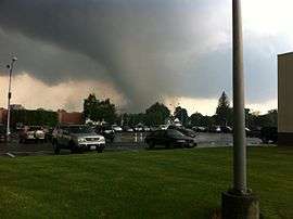 The EF3 tornado that struck Springfield, Massachusetts | |
| Type | Tornado outbreak |
|---|---|
| Duration | June 1, 2011 |
| Tornadoes confirmed | 7 confirmed |
| Max rating1 | EF3 tornado |
| Duration of tornado outbreak2 | 3:35 pm – 6:57 pm EDT (3 hours and 22 minutes) |
| Damage | $140 million (2011 US$)[1] |
| Casualties | 3 deaths[2] |
|
1Most severe tornado damage; see Enhanced Fujita scale 2Time from first tornado to last tornado | |
The 2011 New England tornado outbreak occurred on Wednesday, June 1, 2011, in Massachusetts' Connecticut River Valley and also in southern Maine, devastating sections of the large city of Springfield, Massachusetts and its surrounding region. Although the vast majority of damage occurred in the Connecticut River Valley, the tornado outbreak spawned 7 tornadoes across New England, affecting both Massachusetts and Maine.
By 9:47 pm EDT, the violent storms—which included seven reported tornadoes—had killed three people, injured 300 people in Springfield alone, and left over 500 people homeless in Springfield's MassMutual Center arena.[3][4][5] More than 48,000 electricity customers lost power.[5] Because of the severe weather and resulting damage, Governor Deval Patrick declared a state of emergency for Massachusetts, and on June 14, 2011, President Barack Obama declared Springfield and the surrounding region a United States Federal disaster area.[6] Governor Patrick also activated 1,000 National Guard troops for rescue and recovery efforts.
Meteorological synopsis
On May 30, two days before the outbreak, the Storm Prediction Center (SPC) noted the possibility of a severe weather event in the Northeastern United States in their outlook. A storm system was forecast to draw warm, moist air (with dew points over 60 °F (16 °C)) from the south, ahead of a driving cold front. In light of this, the SPC issued a slight risk for severe thunderstorms the area.[7] As an upper-level trough moved over the Great Lakes, further moisture and warmth increased atmospheric instability in the area, raising the threat of a squall line or supercell thunderstorms.[8] By June 1, the storm system moved over Ontario and Quebec, with a cold front trailing behind it over northern New England. CAPE values exceeded 4,000 J/kg, indicating an extreme amount of instability in the atmosphere, conducive to strong thunderstorms. Additionally, a strong upper-level jet stream brought significant wind shear, which, in combination with the atmospheric instability, indicated a significant severe weather threat, with the main effects expected to result from downburst winds and large hail, but with tornadoes possible.[9] An EML, which emerged over Arizona on May 28, was also present and created abnormally steep mid-level lapse rates, further increasing instability.[10]
Between 8:18 a.m. and 9:15 a.m. (EDT), severe storms producing 1 in (2.5 cm) hail developed over portions of New Hampshire, Massachusetts and Maine; however, little if any impact resulted from these storms.[11] At 10:05 a.m., the SPC issued a severe thunderstorm watch for the entire state of Vermont, much of northern New York, northeastern Pennsylvania and parts of western Massachusetts and Connecticut.[12] By this time, a broken line of severe storms had developed over parts of western New York and northern Pennsylvania.[13] With the storms gradually developing throughout the day and an increasing threat of tornadoes, a tornado watch was issued at 1:00 p.m. for much of New England, southern New York, eastern Pennsylvania and most of New Jersey.[14] Around 2:00 p.m., severe storms with damaging hail, measured up to 2.75 in (7.0 cm), and winds around 60 mph (97 km/h) developed in eastern New York. These storms gradually tracked east-southeastward into Vermont and later New Hampshire. One particular supercell produced very large 3.25-inch (8.3 cm) diameter hail at Shaftsbury, Vermont after producing a funnel cloud and baseball sized hail across the border in New York State.[11] At 2:43 p.m., the first of several tornado warnings in the area was issued for southern Coos County, New Hampshire.[15]
Between 3:00 and 3:30 p.m., severe storms developed over western Massachusetts and prompted a tornado warning to be issued at 3:28 p.m. for parts of Hampden, Hampshire and Franklin Counties.[16] About an hour later, another warning was issued for Springfield, Massachusetts and surrounding areas. Within minutes, a touchdown was confirmed near Springfield by local law enforcement and amateur radio operators.[17] This tornado was later rated a strong EF3 on the Enhanced Fujita Scale.[18] At one point, this supercell displayed radar characteristics similar to historic supercells that produced violent tornadoes, such as Tuscaloosa, AL (2011) and Moore, OK (1999)[19] Over the next hour, damage was reported as far east as Southbridge from this long track tornado. Other brief touchdowns were reported across the state afterward as well, which caused minor damage.
In total, West Springfield, Westfield, Springfield, Monson, Hampden, Wilbraham, Brimfield, Sturbridge,and Southbridge, Massachusetts all sustained damage from the long track EF3 tornado . A total of three (downgraded from the originally reported 4) people were killed as a result of the tornado and at least 200 people were injured from severe weather across the state.[20][21] The outbreak included the first killer tornado in Massachusetts since the 1995 Great Barrington tornado.[22]
Confirmed tornadoes
| EF0 | EF1 | EF2 | EF3 | EF4 | EF5 | Total |
|---|---|---|---|---|---|---|
| 2 | 3 | 0 | 1 | 0 | 0 | 6 |
| List of reported tornadoes – Wednesday, June 1, 2011 | ||||||
|---|---|---|---|---|---|---|
| | | | | | | |
| Maine | ||||||
| EF1 | NW of Bethel | Oxford | 44°24′14″N 70°40′54″W / 44.40383°N 70.68166°W | 3:35 p.m. – 3:36 p.m. | 0.25 miles (0.40 km) | Brief tornado touched down to the northwest of Bethel, snapping or uprooting numerous trees. Tree limbs were thrown up to 0.5 mi (0.80 km) away.[23][24] |
| EF1 | Embden area | Somerset | 44°54′31″N 70°01′38″W / 44.9087°N 70.0273°W | 5:51 p.m. – 6:06 p.m. | 8.4 miles (13.5 km) | Tornado touched down in a rural area of Somerset County. Damage was confined to trees along the entire path. Winds were estimated at 90 to 100 mph (140 to 160 km/h).[25][26] |
| Massachusetts | ||||||
| EF3 | Westfield area to SW Charlton | Hampden, Worcester | 42°06′N 72°45′W / 42.100°N 72.750°W | 4:17 p.m. – 5:27 p.m. | 37 miles (60 km) | 3 deaths – See section on the Greater Springfield tornado |
| EF1 | NW Wilbraham | Hampden | 42°08′N 72°28′W / 42.133°N 72.467°W | 6:32 p.m. – 6:40 p.m. | 4.16 miles (6.69 km) | Numerous trees were downed and large limbs were snapped off some trees. Numerous trees were uprooted, some of which fell onto homes and across roads.[27] |
| EF0 | N of North Brimfield | Hampden | 42°08′N 72°13′W / 42.133°N 72.217°W | 6:54 p.m. – 6:57 p.m. | 1.69 miles (2.72 km) | Several trees were downed, some of which were uprooted, and large limbs were snapped off some trees. Post-event analysis indicated that the tornado was weaker than initially thought.[28] |
| EF0 | NE of Fiskdale | Worcester | 42°09′N 72°04′W / 42.150°N 72.067°W | 7:10 p.m. – 7:13 p.m. | 1.42 miles (2.29 km) | Damage mostly limited to trees; however, one fell on and damaged a home.[29] |
The Greater Springfield tornado
On June 1, 2011, a strong, large, and long-lived tornado left a swath of devastation through Hampden County into Worcester County in Western Massachusetts. The tornado proved to be unusually persistent, remaining on the ground for one hour and ten minutes along a path 39 mi (63 km) long, the second longest on record in Massachusetts.[30] The damage path reached a width of 0.5 miles (0.80 km).[30] The city of Springfield was devastated by the June 1, 2011 tornado, as was the southern portion of the Springfield Metropolitan Area – from Westfield to Charlton. Massachusetts has experienced only eight EF3 or higher tornadoes since reliable records began to be kept in 1950, and this was the first on record in Hampden County.[31] Overall, the tornado killed three people, injured about 200 others, and left hundreds homeless.[32] In Springfield alone, approximately 500 buildings were destroyed.[33] Hundreds of other homes were destroyed in surrounding towns, including West Springfield (88 structures) and Monson (77 structures), among others.[34][35] Damage estimates from the storm, to date, exceed $140 million, the majority of which was from the destruction of homes and businesses.[1] Based on a post-storm survey by the National Weather Service office in Boston, the tornado attained maximum estimated winds of 160 mph (260 km/h) as it moved into Springfield, ranking it as a high-end EF3.[30]
Around 4:13 p.m., a strong thunderstorm developed over western Hampden County and gradually developed as it tracked eastward at 35 mph (56 km/h). This storm prompted a severe thunderstorm warning for portions of Hampden, Hampshire, and Worcester Counties in Massachusetts as well as Hartford, Tolland and Windham Counties in Connecticut. At the time, Doppler weather radar indicated weak rotation within the storm, a sign of a possible tornado and around[36] 4:17 p.m., a tornado touched down in the Munger Hill section of Westfield, Massachusetts.[30] The previous severe thunderstorm warning was then superseded by a tornado warning at 4:18 p.m. following stronger rotation apparent on radar.[17] Within Westfield, damage was mainly confined to trees but a local school did sustain roof damage. Once the tornado moved out of the City of Westfield and into the City of West Springfield, it rapidly intensified, causing extensive damage to industrial buildings, removing roofs and the upper floors of three-story apartment complexes. Additionally, a few homes collapsed due to the severity of structural damage.[30] Throughout West Springfield, 88 buildings were destroyed and two people were killed.[35] One woman was killed after her home collapsed on top of her while she was protecting her daughter.[37] Another fatality took place when a 5 ft (1.5 m) wide oak tree fell on a vehicle, killing the driver.[38]
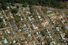
The storm then crossed the Connecticut River and moved into Metro Center, the most urban area of the densely populated City of Springfield,[30] destroying over 500 homes and buildings.[33] The tornado caused extensive damage to Springfield's Connecticut River Walk Park, deforesting much of the park's formerly lush tree canopy and removing large sections of its wrought-iron fences.[39] Some 200-year-old Heritage Trees in Court Square were uprooted and commercial brick buildings in Springfield's historic South End sustained extensive damage – large portions of their roofs were removed and numerous, ornate brick facades were completely destroyed.[40] Severe structural damage to apartments and townhouses took place near famous Mulberry Street and due east on the campus of Springfield College. In the wealthy East Forest Park neighborhood, numerous houses were completely destroyed, and Cathedral High School sustained sufficient damage that it was eventually demolished.[41][42] Some debris from Cathedral High School was found roughly 43 mi (69 km) east, discovered in Millbury.[11] Springfield's Sixteen Acres neighborhood, an upper-middle-class neighborhood – Springfield's most suburban in character – was similarly devastated.[43]
Continuing eastward, the tornado tracked through Wilbraham, causing near-total deforestation and extensive structural damage. The storm then moved through the center of Monson, damaging nearly every structure in the area. Many homes were badly damaged, some of which were completely flattened.[30] A total of 77 buildings were destroyed,[35] some completely. In some locations, trees were debarked and had most of their branches removed. Some unanchored homes in town slid from their foundations and collapsed. The roof of the old Monson High School, which is now the town's police building, was also completely destroyed.[30] In Natick, roughly 60 mi (97 km) from Monson, a picture from the town was found.[44]
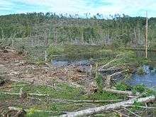
Shortly before 5:00 p.m.,[45] the tornado moved through Brimfield State Forest where it reached its maximum width of 0.5 mi (0.80 km). Thousands of trees were snapped and uprooted in this area.[30] Near Brimfield, the Village Green campground, a trailer park, was almost completely destroyed with 95 out of 96 trailers destroyed. Here, one person was killed after her RV was overturned by the tornado. Several homes were completely swept from their foundation in the Brimfield area as well.[35] Losses in this area exceeded $1 million.[46] Around 5:09 p.m., another tornado warning was issued to include portions of Norfolk County, Massachusetts and Providence County, Rhode Island.[47] The tornado then struck the Sturbridge area, where thousands of trees were downed and multiple homes were damaged. Significant damage took place to both buildings and trees for several miles before the storm moved into Southbridge. There, the Southbridge Airport sustained some damage and aircraft were picked up and thrown into the nearby woods. Once through the airport, the tornado ripped through the Rosemeade Apartments and devastated the neighborhood of Brookside Road, Charlton Street and Harrington Road at 5:18pm before it dissipated in southwestern Charlton at 5:27 p.m.[30]
Aftermath

Immediately following the storms, four people were reported dead, although later it was found that one death was unrelated to the storm.[32] Hundreds of people were admitted to hospitals with injuries ranging from lightning strikes to trauma, and almost 500 people were forced to leave their homes, most of whom stayed in the MassMutual Center.[48][49] Over two weeks later, more than 200 people were still homeless at the MassMutual Center in Springfield.[50] In addition to the MassMutual Center, Tantasqua High School in Sturbridge and Brookfield Elementary School were opened up as emergency shelters. A Special Emergency Response Team was activated by the state police in order to search for missing people and those trapped underneath debris.
In Springfield, firefighters from Boston, Worcester, Newton, Waltham, Watertown, and Weston assisted in rescue efforts.[51][52] Governor Deval Patrick also declared a state of emergency in Massachusetts, and activated 1,000 National Guard troops for rescue and recovery efforts.[53] By June 2, six Red Cross shelters had been opened in the state and housed about 480 people.[54][55] On June 2, 2011, the Business Improvement District of Hartford, Connecticut – Springfield's bi-state twin city – and the Downtown Boston Business Improvement District were helping the Springfield Business Improvement District with clean-up.[56] Within two days of the tornadoes, the process of demolishing 'structures beyond repair' began as local officials inspected hundreds of damaged homes.[57] By June 7, three shelters remained open, housing 362 people.[58] AmeriCorps NCCC (National Civilian Community Corps) deployed their nearby team, Summit 7 of Class 17, to aid the community in debris removal. Armed with chainsaws and other tools, the team spent several weeks helping residents clean up their homes and properties.
On June 15, the Federal Emergency Management Agency (FEMA) declared Hampden and Worcester Counties as major disaster areas, allowing for government aid to be distributed to affected residents.[59] The following day, the number of insurance claims sharply rose from about 5,000 to 8,200. In addition to federal funds, state lawmakers passed a $50.3 million supplemental budget that included $15 million for emergency response, cleanup, and assistance and shelter to residents affected by the storms.[60] By June 20, just over $1 million in individual aid had been provided to 254 households.[59] $3.9M in federal funds were given to cities and towns for emergency items including debris removal and road and sidewalk repair.[61] In addition to assistance from MassDOT and waiving of license replacement fees in June by the Massachusetts Registry of Motor Vehicles, Massport donated $300,000 in unused construction supplies from the Boston Logan Residential Soundproofing Program.[61]
See also
- List of North American tornadoes and tornado outbreaks
- 1989 Northeastern United States tornado outbreak – The previous tornado outbreak to affect the Northeast.
- Tornadoes of 2011
- 1953 Worcester tornado – Most powerful F4 Tornado to affect Massachusetts.
- 1995 Great Barrington tornado – The previous strongest tornado to affect Massachusetts.
References
- 1 2 Vivian Yee (June 18, 2011). "Insurance claims for tornadoes hit $140m". The Boston Globe. Retrieved June 20, 2011.
- ↑ "Annual Fatal Tornado Summaries". Storm Prediction Center. National Oceanic and Atmospheric Administration. 2011. Archived from the original on June 13, 2011. Retrieved June 20, 2011.
- ↑ "WGGB abc40/FOX 6: News, Weather, Sports: Springfield, MA – Home". Wggb.com. June 20, 2011. Retrieved March 27, 2012.
- ↑ Parsons, Christi (June 11, 2011). "Gov. Deval Patrick requests federal disaster aid for tornadoes". BostonHerald.com. Retrieved March 27, 2012.
- 1 2 Finucane, Martin (June 1, 2011). "Four fatalities confirmed as tornadoes rip through Mass.". Boston Globe. Retrieved June 1, 2011.
- ↑ Patrick Johnson. "President Obama's disaster area declaration opens door for federal aid, buoys hopes of tornado-tossed communities in Western Massachusetts". masslive.com. Retrieved March 27, 2012.
- ↑ Greg L. Dial (May 30, 2011). "May 30, 2011 0730 UTC Day 3 Severe Thunderstorm Outlook". Storm Prediction Center. National Oceanic and Atmospheric Administration. Archived from the original on June 14, 2011. Retrieved June 3, 2011.
- ↑ Greg L. Dial (May 31, 2011). "May 31, 2011 0600 UTC Day 2 Convective Outlook". Storm Prediction Center. National Oceanic and Atmospheric Administration. Archived from the original on June 14, 2011. Retrieved June 3, 2011.
- ↑ Ryan E. Jewell; Melissa M. Hurlbut (June 1, 2011). "Jun 1, 2011 0600 UTC Day 1 Convective Outlook". Storm Prediction Center. National Oceanic and Atmospheric Administration. Archived from the original on June 14, 2011. Retrieved June 3, 2011.
- ↑ "NOAA a multiscale analysis of the 1 june 2011 northeast us severe weather outbreak" (PDF).
- 1 2 3 "SPC Storm Reports for June 1, 2011". Storm Prediction Center. National Oceanic and Atmospheric Administration. June 3, 2011. Archived from the original on June 14, 2011. Retrieved June 3, 2011.
- ↑ John A. Hart (June 1, 2011). "Severe Thunderstorm Watch 410". Storm Prediction Center. National Oceanic and Atmospheric Administration. Archived from the original on June 14, 2011. Retrieved June 3, 2011.
- ↑ Richard L. Thompson; Johnathan M. Garner (June 1, 2011). "Jun 1, 2011 1300 UTC Day 1 Convective Outlook". Storm Prediction Center. National Oceanic and Atmospheric Administration. Archived from the original on June 14, 2011. Retrieved June 3, 2011.
- ↑ John A. Hart (June 1, 2011). "Tornado Watch 411". Storm Prediction Center. National Oceanic and Atmospheric Administration. Archived from the original on June 14, 2011. Retrieved June 3, 2011.
- ↑ "Severe Weather Statement: Tornado Warning". National Weather Service Office in Gray, Maine. Iowa Environmental Mesonet National Weather Service. June 1, 2011. Archived from the original on May 11, 2011. Retrieved June 3, 2011.
- ↑ "Severe Weather Statement: Tornado Warning". National Weather Service Office in Boston, Massachusetts. Iowa Environmental Mesonet National Weather Service. June 1, 2011. Archived from the original on May 11, 2011. Retrieved June 3, 2011.
- 1 2 "Severe Weather Statement: Tornado Warning". National Weather Service Office in Boston, Massachusetts. Iowa Environmental Mesonet National Weather Service. June 1, 2011. Archived from the original on May 11, 2011. Retrieved June 5, 2011.
- ↑ Field Survey Team (June 3, 2011). "Some Preliminary Tornado Survey Information". National Weather Service Office in Boston, Massachusetts. National Oceanic and Atmospheric Administration. Retrieved June 3, 2011.
- ↑ "A Multiscale Analysis of the 1 June 2011 Northeast U.S. Severe Weather Outbreak and Associated Springfield, Massachusetts Tornado" (PDF).
- ↑ "Massachusetts digs out after three tornadoes kill 3, hurt 200". Fox 25 News. June 3, 2011. Retrieved June 8, 2011.
- ↑ http://investmentwatchblog.com/mass-tornado-update-about-200-injured-50000-still-without-power-crews-searching-for-survivors-amid-debris/
- ↑ "Death reported in tornado". WWLP.com. June 1, 2011. Retrieved June 1, 2011.
- ↑ "Public Information Statement". National Weather Service in Gray, Maine. Retrieved June 4, 2011.
- ↑ "Maine Event Report: EF1 Tornado". National Climatic Data Center. 2011. Retrieved October 26, 2011.
- ↑ "Public Information Statement". National Weather Service in Gray, Maine. Retrieved June 4, 2011.
- ↑ "Maine Event Report: EF1 Tornado". National Climatic Data Center. 2011. Retrieved October 26, 2011.
- ↑ "Massachusetts Event Report: EF1 Tornado". National Climatic Data Center. 2011. Retrieved October 26, 2011.
- ↑ "Massachusetts Event Report: EF0 Tornado". National Climatic Data Center. 2011. Retrieved October 26, 2011.
- ↑ "Massachusetts Event Report: EF0 Tornado". National Climatic Data Center. 2011. Retrieved October 26, 2011.
- 1 2 3 4 5 6 7 8 9 10 Robert M. Thompson Jr.; David R. Manning; Joseph Dellicarpini; Alan E. Dunham; Matthew L. Doody; Eleanor Vallier-Talbot; Tracy L. Mccormick (June 3, 2011). "Three Tornadoes Confirmed on June 1, 2011 in Massachusetts". National Weather Service office in Boston, Massachusetts. National Oceanic and Atmospheric Administration. Retrieved June 5, 2011.
- ↑ "Massachusetts Tornado History (1950–2010)". National Climatic Data Center. Tornado History Project. 2011. Retrieved June 4, 2011.
- 1 2 David Abel; Brian MacQuarrie (June 2, 2011). "'It looks like a war zone'". Th Boston Globe. Retrieved June 26, 2011.
- 1 2 "Tornado that struck Springfield needn't wreck its finances, too". The Boston Globe.
- ↑ Jessica Fargen; Marie Szaniszlo (June 5, 2011). "Massive recovery effort in tornado zone". Boston Herald. Archived from the original on June 5, 2011. Retrieved June 5, 2011.
- 1 2 3 4 Aaron Nicodemus; John J. Monahan (June 3, 2011). "Damage assessment". Worcester Telegram & Gazette. Archived from the original on June 5, 2011. Retrieved June 5, 2011.
- ↑ "Severe Weather Statement: Severe Thunderstorm Warning". National Weather Service Office in Boston, Massachusetts. Iowa Environmental Mesonet National Weather Service. June 1, 2011. Archived from the original on May 11, 2011. Retrieved June 5, 2011.
- ↑ Eric Moskowitz; Jenna Russell (June 3, 2011). "With storm raging, a mother makes the ultimate sacrifice". The Boston Globe. Retrieved June 5, 2011.
- ↑ Jessica Heslam (June 2, 2011). "Brother's tornado death rocks West Springfield family". Boston Herald. Archived from the original on June 5, 2011. Retrieved June 5, 2011.
- ↑ "Tornado Damages Connecticut River Walk in Springfield, Mass. – RTC TrailBlog – Rails-to-Trails Conservancy". Community.railstotrails.org. Retrieved March 27, 2012.
- ↑ "Governor Patrick, Sen. Kerry survey destruction in western Massachusetts". GazetteNET. Retrieved March 27, 2012.
- ↑ "Springfield's Cathedral High School future settled 3 years after tornado". MassLIVE. Retrieved July 2, 2014.
- ↑ "Cathedral High School: A review of the latest stories on future of Springfield school". MassLIVE. Retrieved March 6, 2016.
- ↑ Mark M. Murray. "Springfield Tornado aftermath | masslive.com". Photos.masslive.com. Retrieved March 27, 2012.
- ↑ Alissa Letkowski (June 4, 2011). "Monson Family Recognizes Son's Photo Blown to Natick by Tornado". Natick Patch. Archived from the original on June 5, 2011. Retrieved June 5, 2011.
- ↑ Travis Andersen (June 2, 2011). "In Brimfield, terror – and death – arrived in a cloud laden with debris". The Boston Globe. Retrieved June 5, 2011.
- ↑ M.R.F. Buckley (June 3, 2011). "Destruction To Demolition, Tornado Cleanup Begins". WCBV-TV. Retrieved June 3, 2011.
- ↑ "Severe Weather Statement: Tornado Warning". National Weather Service Office in Boston, Massachusetts. Iowa Environmental Mesonet National Weather Service. June 1, 2011. Archived from the original on May 11, 2011. Retrieved June 5, 2011.
- ↑ Post, Paul (June 3, 2011). "Area Red Cross volunteers sent to aid tornado victims in Springfield, Mass.". Saratoga Springs, N.Y.: The Saratogian. Retrieved March 27, 2012.
- ↑ Flynn, Jack (June 3, 2011). "Springfield tornado death toll at 3; Massachusetts Congressional delegation appeals to President Obama for disaster declaration". Springfield, Mass.: MassLive.com. Retrieved March 27, 2012.
- ↑ Shane Symolon. "Hundreds still homeless after tornadoes". WWLP.com. Retrieved March 27, 2012.
- ↑ Jimenez, Monica (June 6, 2011). "Chelmsford firefighters collect for Springfield tornado relief – Chelmsford, Massachusetts – Chelmsford Independent". Wickedlocal.com. Retrieved March 27, 2012.
- ↑ Bronislaus B. Kush; Nick Kotsopoulos; Lee Hammel; Gerard F. Russell; Robert Kievra; Jacqueline Reis (June 1, 2011). "Tornadoes rip across state; 4 dead". Worcester Telegram. Associated Press. Archived from the original on June 20, 2011. Retrieved June 20, 2011.
- ↑ Forer, Ben; Michael S. James (June 1, 2011). "Massachusetts Rocked by Tornadoes, Including City of Springfield; 4 Dead". ABC News. Retrieved June 1, 2011.
- ↑ "Red Cross Helping After Tornadoes Tear Through Massachusetts". PR Newswire. June 2, 2011. Archived from the original on June 20, 2011. Retrieved June 20, 2011.
- ↑ Renee Nadeau Algarin (June 2, 2011). "Red Cross asks for help for victims". Boston Herald. Archived from the original on June 20, 2011. Retrieved June 20, 2011.
- ↑ Mark M. Murray. "Tornado clean up continued Friday in Springfield | masslive.com". Photos.masslive.com. Retrieved March 27, 2012.
- ↑ Dave Collins (June 3, 2011). "W. Mass. picking up the pieces after tornadoes". The Boston Globe. Associated Press. Archived from the original on June 20, 2011. Retrieved June 20, 2011.
- ↑ Jessica Heslam (June 7, 2011). "Officials assess damage". Boston Herald. Retrieved June 20, 2011.
- 1 2 "Massachusetts Severe Storms and Tornadoes". Federal Emergency Management Agency. June 20, 2011. Retrieved June 20, 2011.
- ↑ Johanna Kaiser (June 16, 2011). "Mass. tornado claims rise; more funding offered". The Boston Globe. Associated Press. Archived from the original on June 20, 2011. Retrieved June 20, 2011.
- 1 2 "Commonwealth Conversations / Transportation / Springfield: Tornado Relief Road Repair Funds". May 2012. Retrieved 2012-06-04.
External links
| Wikimedia Commons has media related to 2011 New England tornado outbreak. |
- Doppler weather radar reflectivities and velocities loops of the June 1 tornado outbreak
- Time-lapse visualization of the June 1 tornado outbreak