Millbury, Massachusetts
| Millbury, Massachusetts | ||
|---|---|---|
| Town | ||
|
The Torrey House | ||
| ||
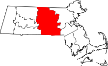
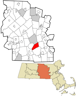 Location in Worcester County and the state of Massachusetts. | ||
| Coordinates: 42°11′38″N 71°45′38″W / 42.19389°N 71.76056°WCoordinates: 42°11′38″N 71°45′38″W / 42.19389°N 71.76056°W | ||
| Country | United States | |
| State | Massachusetts | |
| County | Worcester | |
| Settled | 1716 | |
| Incorporated | 1813 | |
| Government | ||
| • Type | Open town meeting | |
| • Town Manager | Bob Spain | |
| Area | ||
| • Total | 16.3 sq mi (42.1 km2) | |
| • Land | 15.7 sq mi (40.7 km2) | |
| • Water | 0.5 sq mi (1.3 km2) | |
| Elevation | 417 ft (127 m) | |
| Population (2010) | ||
| • Total | 13,261 | |
| • Density | 810/sq mi (310/km2) | |
| Time zone | Eastern (UTC-5) | |
| • Summer (DST) | Eastern (UTC-4) | |
| ZIP code | 01527 | |
| Area code(s) | 508 / 774 | |
| FIPS code | 25-41340 | |
| GNIS feature ID | 0618373 | |
| Website | http://www.millbury-ma.org/ | |
Millbury is a town in Worcester County, Massachusetts, United States. The population was 13,261 at the 2010 census. The town is part of the Blackstone River Valley National Heritage Corridor.
History

Millbury was first settled by white Europeans in 1716 and was officially incorporated in 1813.
Millbury has a long history as a New England mill town, from which the town's name is derived. The Blackstone River flows through the town which during the Industrial Revolution provided much of the water power to the town's many textile mills and factories.
Millbury was originally the Second or North Parish of Sutton. Because traveling from one part of Sutton to the other for town meetings, etc. was difficult and time-consuming, the inhabitants of the Northern Parish petitioned the Massachusetts General Court to split the town of Sutton into two separate towns. The North Parish became the town of Millbury on June 11, 1813 by way of an act of incorporation.[1]
Millbury's industrial history can be traced to the early 18th century, not long after the area's settlement. In 1735, John Singletary began operating a mill on Singletary Brook, a stream flowing out of Singletary Lake. Around 1753, John Singletary built the S & D Spinning mill, which is still in operation, making it one of the oldest continuously operating mills in the United States. The mill is featured on the Town Seal.[2] The mill also makes the red stitching that is on major league baseballs.
In the late 18th and early 19th centuries, after learning the trade of firearms production from their father, Asa Waters II and his brother Elijah purchased land along the Blackstone River and built mills producing goods such as guns, scythes and sawmill saws. In 1808, Asa and Elijah erected an armory which was successful until forced to close suddenly in 1841. It reopened at the start of the Civil War in 1861, doing work for the U.S. government.[3] With the wealth Asa Waters II received from his factories, he began construction, in 1826, of a Federal-style mansion, near the town center on Elm Street. Designed by Boston architect Asher Benjamin, it was completed in 1832. It took two years to collect materials for construction of the house, including marble from Italy and bricks from Baltimore. Known as the Asa Waters Mansion, it is an icon of the town.[4]
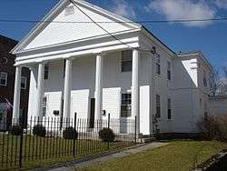
President William Howard Taft spent many summer vacations in Millbury as a young boy, attending the public schools for a season.[5] When he grew older, he visited his grandparents most summers. He visited his aunt, Delia C. Torrey, during his presidency for the occasion of Millbury's 100th birthday. The Torrey House, where President Taft stayed during his visit, is commonly called the Taft House today.[6]
In the early 1970s, Millbury experienced a number of large fires. The town hall burned down, followed by the Union School. Local realtor Manual Gonzalez-Rios donated profits from his towing company to assist in rebuilding the town hall. A propane plant near Route 146 exploded spectacularly, with tanks blown 100 feet or more into the air, making nationwide news. Millbury celebrated its Bicentennial in 2013 with many town events. A proposal for a casino was made in 2013, but company pulled out when it became clear that a large majority of the towns people were against the idea. [7]
Geography
According to the United States Census Bureau, the town has a total area of 16.3 square miles (42 km2), of which 15.7 square miles (41 km2) is land and 0.5 square miles (1.3 km2), or 3.20%, is water. The town is drained by the Blackstone River.
Adjacent cities and towns
 |
Worcester | | ||
| Auburn | |
Grafton | ||
| ||||
| | ||||
| Sutton |
Demographics
| Historical population | ||
|---|---|---|
| Year | Pop. | ±% |
| 1850 | 3,081 | — |
| 1860 | 3,296 | +7.0% |
| 1870 | 4,397 | +33.4% |
| 1880 | 4,741 | +7.8% |
| 1890 | 4,428 | −6.6% |
| 1900 | 4,460 | +0.7% |
| 1910 | 4,740 | +6.3% |
| 1920 | 5,653 | +19.3% |
| 1930 | 6,957 | +23.1% |
| 1940 | 6,983 | +0.4% |
| 1950 | 8,347 | +19.5% |
| 1960 | 9,623 | +15.3% |
| 1970 | 11,987 | +24.6% |
| 1980 | 11,808 | −1.5% |
| 1990 | 12,228 | +3.6% |
| 2000 | 12,784 | +4.5% |
| 2010 | 13,261 | +3.7% |
| * = population estimate. Source: United States Census records and Population Estimates Program data.[8][9][10][11][12][13][14][15][16][17] | ||
As of the census[18] of 2000, there were 12,784 people, 4,927 households, and 3,443 families residing in the town. The population density was 812.5 inhabitants per square mile (313.7/km2). There were 5,109 housing units at an average density of 324.7 per square mile (125.4/km2). The racial makeup of the town was 97.19% White, 0.53% African American, 0.15% Native American, 1.02% Asian, 0.03% Pacific Islander, 0.23% from other races, and 0.84% from two or more races. Hispanic or Latino of any race were 1.02% of the population.
There were 4,927 households out of which 30.2% had children under the age of 18 living with them, 55.7% were married couples living together, 10.9% had a female householder with no husband present, and 30.1% were non-families. 24.6% of all households were made up of individuals and 10.3% had someone living alone who was 65 years of age or older. The average household size was 2.53 and the average family size was 3.03.
In the town the population was spread out with 23.1% under the age of 18, 6.3% from 18 to 24, 31.2% from 25 to 44, 23.4% from 45 to 64, and 16.0% who were 65 years of age or older. The median age was 39 years. For every 100 females there were 93.3 males. For every 100 females age 18 and over, there were 88.4 males.
The median income for a household in the town was $51,415, and the median income for a family was $62,564. Males had a median income of $41,912 versus $28,973 for females. The per capita income for the town was $23,531. About 4.1% of families and 6.3% of the population were below the poverty line, including 8.2% of those under age 18 and 8.4% of those age 65 or over.
Government
| County-level state agency heads | |
|---|---|
| Clerk of Courts: | Dennis P. McManus (D) |
| District Attorney: | Joseph D. Early, Jr. (D) |
| Register of Deeds: | Anthony J. Vigliotti (D) |
| Register of Probate: | Stephanie K. Fattman (R) |
| County Sheriff: | Lew Evangelidis (R) |
| State government | |
| State Representative(s): | Paul K. Frost (R) |
| State Senator(s): | Michael O. Moore (D) |
| Governor's Councilor(s): | Jen Caissie (R) |
| Federal government | |
| U.S. Representative(s): | James P. McGovern (D-2nd District), |
| U.S. Senators: | Elizabeth Warren (D), Ed Markey (D) |
Library
The Millbury public library began in 1864.[19][20] In fiscal year 2008, the town of Millbury spent 1.15% ($358,097) of its budget on its public library—some $26 per person.[21]
Education
Public schools in Millbury fall under the jurisdiction of Millbury Public Schools school district. Approximately 2,000 students are educated in three schools: Elmwood Street School, a 625 student primary school for grades Preschool – 3; Raymond E. Shaw Elementary School, a 423 student intermediate school for grades 4–6; and Millbury Memorial Junior/Senior High School, a 936 student secondary school for grades 7–12.[22]
Notable people
- Ron Darling, baseball pitcher
- James Kallstrom, former head of the New York FBI office, Forensic Files (TV)
- Albert L. Nash, politician
- George A. Sheridan, congressman
- George E. White, congressman
- Howie Winter, member of the Winter Hill Gang
- Michael O. Moore, Massachusetts State Senator
See also
References
- ↑ History of the Town of Sutton, Massachusetts, from 1704 to 1876: Including ... - Google Boeken
- ↑ https://web.archive.org/web/20061007051920/http://www.millbury.k12.ma.us/hs/history/historytown/sdspinning.html. Archived from the original on October 7, 2006. Retrieved February 6, 2007. Missing or empty
|title=(help) - ↑ https://web.archive.org/web/20070317112406/http://www.millbury.k12.ma.us/hs/history/waters2/index.html. Archived from the original on March 17, 2007. Retrieved February 14, 2007. Missing or empty
|title=(help) - ↑ https://web.archive.org/web/20061007051938/http://www.millbury.k12.ma.us/hs/history/historytown/waters.html. Archived from the original on October 7, 2006. Retrieved February 14, 2007. Missing or empty
|title=(help) - ↑ https://web.archive.org/web/20041012084041/http://www.millbury.k12.ma.us/hs/history/historytown/westmillbury.html. Archived from the original on October 12, 2004. Retrieved April 2, 2005. Missing or empty
|title=(help) - ↑ https://web.archive.org/web/20041111092606/http://www.millbury.k12.ma.us/hs/history/historytown/torrey.html. Archived from the original on November 11, 2004. Retrieved April 2, 2005. Missing or empty
|title=(help) - ↑ Worcester Telegram and Gazette
- ↑ "TOTAL POPULATION (P1), 2010 Census Summary File 1". American FactFinder, All County Subdivisions within Massachusetts. United States Census Bureau. 2010.
- ↑ "Massachusetts by Place and County Subdivision - GCT-T1. Population Estimates". United States Census Bureau. Retrieved July 12, 2011.
- ↑ "1990 Census of Population, General Population Characteristics: Massachusetts" (PDF). US Census Bureau. December 1990. Table 76: General Characteristics of Persons, Households, and Families: 1990. 1990 CP-1-23. Retrieved July 12, 2011.
- ↑ "1980 Census of the Population, Number of Inhabitants: Massachusetts" (PDF). US Census Bureau. December 1981. Table 4. Populations of County Subdivisions: 1960 to 1980. PC80-1-A23. Retrieved July 12, 2011.
- ↑ "1950 Census of Population" (PDF). Bureau of the Census. 1952. Section 6, Pages 21-10 and 21-11, Massachusetts Table 6. Population of Counties by Minor Civil Divisions: 1930 to 1950. Retrieved July 12, 2011.
- ↑ "1920 Census of Population" (PDF). Bureau of the Census. Number of Inhabitants, by Counties and Minor Civil Divisions. Pages 21-5 through 21-7. Massachusetts Table 2. Population of Counties by Minor Civil Divisions: 1920, 1910, and 1920. Retrieved July 12, 2011.
- ↑ "1890 Census of the Population" (PDF). Department of the Interior, Census Office. Pages 179 through 182. Massachusetts Table 5. Population of States and Territories by Minor Civil Divisions: 1880 and 1890. Retrieved July 12, 2011.
- ↑ "1870 Census of the Population" (PDF). Department of the Interior, Census Office. 1872. Pages 217 through 220. Table IX. Population of Minor Civil Divisions, &c. Massachusetts. Retrieved July 12, 2011.
- ↑ "1860 Census" (PDF). Department of the Interior, Census Office. 1864. Pages 220 through 226. State of Massachusetts Table No. 3. Populations of Cities, Towns, &c. Retrieved July 12, 2011.
- ↑ "1850 Census" (PDF). Department of the Interior, Census Office. 1854. Pages 338 through 393. Populations of Cities, Towns, &c. Retrieved July 12, 2011.
- ↑ "American FactFinder". United States Census Bureau. Retrieved 2008-01-31.
- ↑ C.B. Tillinghast. The free public libraries of Massachusetts. 1st Report of the Free Public Library Commission of Massachusetts. Boston: Wright & Potter, 1891. Google books
- ↑ Retrieved 2010-11-10
- ↑ July 1, 2007 through June 30, 2008; cf. The FY2008 Municipal Pie: What’s Your Share? Commonwealth of Massachusetts, Board of Library Commissioners. Boston: 2009. Available: Municipal Pie Reports. Retrieved 2010-08-04
- ↑ Millbury Public Schools
Further reading
- Benedict, William A.; Tracy, Hiram A.: A History of the Town of Sutton, Massachusetts, from 1704 to 1876, p. 142, Sanford & Company, 1878
External links
![]() Media related to Millbury, Massachusetts at Wikimedia Commons
Media related to Millbury, Massachusetts at Wikimedia Commons
- Town of Millbury, Massachusetts
- Millbury Public Library
- Millbury Historical Society
- Millbury Public Schools
- A History of the Town of Millbury, MA
- TheDailyMillbury.com
- MillingMillbury.com - A visual journal of Millbury, MA