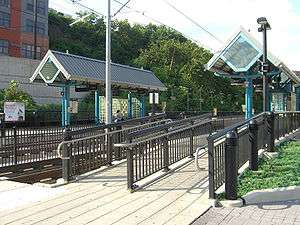
2nd Street (HBLR station)
2nd Street | |||||||||||||||
|---|---|---|---|---|---|---|---|---|---|---|---|---|---|---|---|
 | |||||||||||||||
| Location |
Second & Marshall Streets Hoboken, NJ | ||||||||||||||
| Coordinates | 40°44′30″N 74°02′34″W / 40.7416°N 74.0428°WCoordinates: 40°44′30″N 74°02′34″W / 40.7416°N 74.0428°W | ||||||||||||||
| Owned by | New Jersey Transit | ||||||||||||||
| Line(s) | |||||||||||||||
| Platforms | 2 side platforms | ||||||||||||||
| Tracks | 2 | ||||||||||||||
| Connections |
(on Paterson Avenue) | ||||||||||||||
| Construction | |||||||||||||||
| Disabled access | Yes | ||||||||||||||
| Other information | |||||||||||||||
| Fare zone | 1 | ||||||||||||||
| History | |||||||||||||||
| Opened | September 7, 2004 | ||||||||||||||
| Electrified | 750 V (DC) overhead catenary | ||||||||||||||
| Traffic | |||||||||||||||
| Passengers (2006) |
72,800 | ||||||||||||||
| Services | |||||||||||||||
| |||||||||||||||
2nd Street is a station on the Hudson–Bergen Light Rail (HBLR) located west of Marshall Street near the foot of Paterson Plank Road in Hoboken, New Jersey. There are two tracks and two side platforms.
Service
| destination | route | transfers |
|---|---|---|
| Tonnelle northbound |
Lincoln Harbor Port Imperial Bergenline |
At Port Imperial: New York Waterway At Bergenline: NJT buses and guaguas |
| Hoboken Terminal southbound |
Hoboken | At Hoboken Terminal: PATH to Midtown Manhattan & WTC, NJT/MTA regrional rail Hudson Place bus station New York Waterway |
| Jersey City West Side southbound |
Newport Mall Exchange Place Paulus Hook Liberty State Park |
At Exchange Place: PATH to WTC, Journal Square, Newark Penn Station NJT buses Paulus Hook Ferry Terminal |
| Bayonne | Greenville and Bayonne require transfer at stations between Pavonia-Newport and Liberty State Park. | |
Northbound
Northbound, both of two lines travel along the base of the Hudson Palisades in Hoboken to North Hudson and terminate at Tonnelle Avenue in North Bergen.
Southbound
Hoboken Terminal is the next and final stop for one of the southbound lines, where connection are available for PATH trains, New Jersey Transit regional rail, and NY Waterway ferries. The other southbound line travels thorough Downtown Jersey City to Liberty State Park, then west to MLK Station and its terminus at West Side Avenue. Transfers to PATH trains to Newark, Harrison, and Downtown Manhattan are available at Exchange Place.
Bus Transfer
New Jersey Transit bus routes 22X, 85, 87, and 89 stop just south of the station at Paterson Avenue. The routes travel northbound along Paterson Plank Road to Jersey City Heights and westbound to Hoboken Terminal.
History
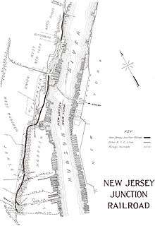
The station opened on September 7, 2004. The right of way on which it is situated was originally part of the New York Central New Jersey Junction Railroad, which maintained a station there. It was later used by the Penn Central River Division and[1] the Conrail River Line before being abandoned to make way for the current system.[2] The station is located at the foot of the Hudson Palisades. In 2003, Jersey City agreed with a developer of a nearby factory-to-housing conversion to cover the cost of an outdoor public stairway from Jersey City Heights to the station. The stairway was never built and in June 2011 the city took responsibility for the project.[3] The steel steps were opened in November 2013.[4]
Station art
Station art was installed at the same time that the station opened. "A Planetary Park" features nine planets depicted in their relative scale and position to the sun. Artist John van Alstine constructed the Sun and a functioning sundial. Grace Graupe-Pillard fabricated the nine fiberglass planets with painted steel figurative attachments, as a metaphor for the celebration of the individual and his/her connection to the world.
References
- ↑ Penn Central Rivier Division map
- ↑ EPA-IMPACT 2000
- ↑ Hunger, Matt (June 16, 2011). "Jersey City Takes Over '100 Steps' Project". Jersey City Independent. Retrieved 2011-08-25.
- ↑ http://www.nj.com/jjournal-news/index.ssf/2013/11/jersey_city_heights_gets_new_s.html
External links
- NJT Hudson–Bergen Light Rail station information page for 2nd Street
- Hudson–Bergen Light Rail schedule
- Subway Nut station info and photos
- 2nd Street entrance from Google Maps Street View
| Wikimedia Commons has media related to 2nd Street (HBLR station). |