Aïn Arnat
| Aïn Arnat عين أرنات | |
|---|---|
| Commune and town | |
| Motto: By the people and for the people | |
 | |
| Country |
|
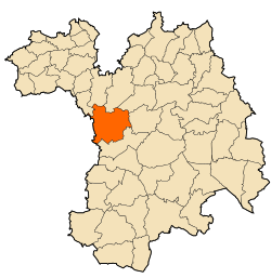
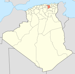
| Province | Sétif Province |
| Area | |
| • Land | 7,820 sq mi (202,55 km2) |
| Population (2008) | |
| • Total | 43 551 |
| Time zone | CET (UTC+1) |
Aïn Arnat (in arabic : عين أرنات) is a town and commune in Sétif Province in north-eastern Algeria.[1]
Geography
Aïn Arnat is located 7 km east of the city of Sétif and 293 km from the capital Algiers. The Daïra of Aïn Arnat has four communes which are Aïn Arnat , Aïn Abessa ,El Ouricia and Mezloug.
Borders
Bordered by Ain Abessa commune from the north,Mezloug from the south, Sétif from the east and by Bordj Bou Arréridj Province from the west
Demography
The total population of Aïn Arnat was evaluated at 43 551 inhabitants in 2008 with a density of 215 hab/km²
Education
Aïn Arnat district has two high schools which are Loulou Ali high school and Malek bennabi high school. And four middle schools wich are : Rahmani abd rahmane , November 1, 1945 , October 17, 1961 , Haddad Larbi middle schools. And more than 12 Primary schools
Transportation
Aïn Arnat has the main and only Airport in Sétif which is Ain Arnat Airport or Sétif International Airport Adding to that The National road N°5 which passes by it , and that makes it one of the most important communes in the wilaya of Sétif
References
- ↑ "Communes of Algeria". Statoids. Archived from the original on 29 November 2010. Retrieved December 12, 2010.
Coordinates: 36°11′N 5°19′E / 36.183°N 5.317°E