Rye, East Sussex
| Rye | |
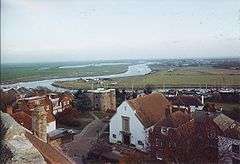 The Ypres tower, Rother, Rye Harbour and marshes seen from the tower of St Mary's church, Rye. |
|
 Rye |
|
| Area | 4.2 km2 (1.6 sq mi) [1] |
|---|---|
| Population | 9,041 (Parish-2012)[1] |
| – density | 2,810/sq mi (1,080/km2) |
| OS grid reference | TQ920206 |
| – London | 53 miles (85 km) NW |
| District | Rother |
| Shire county | East Sussex |
| Region | South East |
| Country | England |
| Sovereign state | United Kingdom |
| Post town | RYE |
| Postcode district | TN31 |
| Dialling code | 01797 |
| Police | Sussex |
| Fire | East Sussex |
| Ambulance | South East Coast |
| EU Parliament | South East England |
| UK Parliament | Hastings and Rye |
| Website | Town Council |
|
|
Coordinates: 50°57′N 0°44′E / 50.95°N 0.73°E
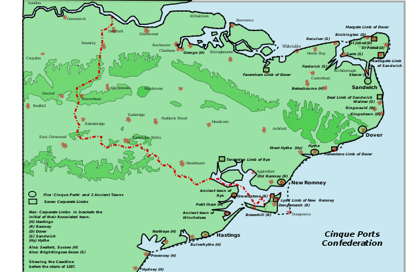
Rye is a small town in the non-metropolitan county of East Sussex, within the historic County of Sussex, England, which stands approximately two miles from the open sea and is at the confluence of three rivers: the Rother, the Tillingham and the Brede. In medieval times, however, as an important member of the Cinque Ports confederation, it was at the head of an embayment of the English Channel and almost entirely surrounded by the sea.
Rye is officially a civil parish but with its historic roots has the status of a town; at the 2011 census it had a population of 4773.[2] During its history its association with the sea has included providing ships for the service of the King in time of war, and being involved with smuggling gangs of the 18th and 19th centuries such as the notorious Hawkhurst Gang who used its inns such as The Mermaid Inn and The Olde Bell Inn, connected by secret passageway.
Those historic roots and its charm[3] make it a tourist destination, and much of its economy is based on that: there are a number of hotels, guest houses, B&Bs, tea rooms and restaurants,[4] as well as other attractions, catering for the visitor. There is a small fishing fleet, and Rye Harbour has facilities for yachts and other vessels.
History
The name of Rye is believed to come from rie meaning a bank.[5] Medieval maps show that Rye was originally located on a huge embayment of the English Channel called the Rye Camber, which provided a safe anchorage and harbour. Probably as early as Roman times, Rye was important as a place of shipment and storage of iron from the Wealden Iron Industry. The Mermaid Inn originally dates to 1156.
Rye, as part of the Saxon Manor of Rameslie, was given to the Benedictine Abbey of Fécamp in Normandy by King Æthelred; it was to remain in Norman hands until 1247.
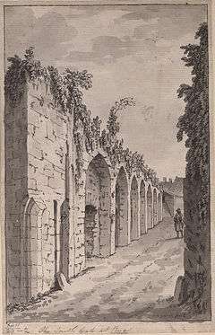
As one of the two "Antient Townes" (Winchelsea being the other), Rye was to become a limb of the Cinque Ports Confederation by 1189, and subsequently a full member. The protection of the town as one of the Cinque Ports was very important, due to the commerce that trading brought. One of the oldest buildings in Rye is Ypres Tower, which was built in 1249 as "Baddings Tower", to defend the town from the French, and was later named after its owner John de Ypres. It is now part of the Rye Museum.[6] Rye received its charter from King Edward I in 1289, and acquired privileges and tax exemptions in return for ship-service for the crown. The "Landgate" (the only surviving one of four original fortified entrances to Rye) dates from 1329 in the early years of the reign of King Edward III. It is still the only vehicular route into the medieval centre of Rye and is suitable only for light vehicles. In 2015, some 25 tonnes of pigeon excrement that had built up had to be removed from Landgate Arch for fear of damaging the ancient structure.[7]
The River Rother originally took an easterly course to flow into the sea near what is now New Romney. However, the violent storms in the 13th century (particularly in 1250 and 1287) cut the town off from the sea, destroyed Old Winchelsea and changed the course of the Rother. Then the sea and the river combined in about 1375 to destroy the eastern part of the town and ships began use the current area (the Strand) to unload their cargoes. Two years later the town was sacked and burnt by the French, and it was ordered that the town walls be completed,[8] as a defence against foreign raiders.
Rye was considered one of the finest of the Cinque Ports even though constant work had to be done to stop the gradual silting-up of the river and the harbour. There was also a conflict of interest between the maritime interests and the landowners, who gradually "inned" or reclaimed land from the sea on Romney and Walland Marsh and thus reduced the tidal-flows that were supposed to keep the harbour free of silt.[9] Acts of Parliament had to be passed to enable the Rother to be kept navigable at all.
With the coming of bigger ships and larger deepwater ports, Rye's economy began to decline, and fishing and particularly smuggling (including owling, the smuggling of wool) became more important. Imposition of taxes on goods had encouraged smuggling since 1301, but by the end of the 17th century it became widespread throughout Kent and Sussex, with wool being the largest commodity. When luxury goods were also added, smuggling became a criminal pursuit, and groups – such as the Hawkhurst Gang who met in The Mermaid Inn in Rye – turned to murder and were subsequently hanged.
Since 1803 there have been lifeboats stationed at Rye[10] although the lifeboat station is now at Rye Harbour approx 2 miles (3.2 km) down-river from the town.[11] The worst disaster in its history occurred in 1928, when the Mary Stanford Lifeboat sank with all hands. The incident is recorded by a tablet at Winchelsea church, by the imposing memorial at Rye Harbour Church and by the folk-song The Mary Stanford of Rye.[12] A new RNLB Mary Stanford was commissioned by the RNLI two years later and stationed at Ballycotton on the coast of Ireland. Since 2010 the RNLI has operated an Atlantic 85 class inshore lifeboat at Rye harbour.
Between 1696 and 1948 there have been six ships of the Royal Navy to bear the name HMS Rye.
During the 1803–1805 Napoleonic invasion threat, Rye, Dover and Chatham were regarded as the three most likely Invasion Ports[13] and Rye became the western Command centre for the Royal Military Canal. The canal was planned from Pett Level to Hythe as a defence against a possible French invasion. How a 20-metre ditch was supposed to have stopped the finest army in Europe, which had already crossed all of Europe's great rivers at one time or another, was not clear. In the event, the canal was not completed until long after the need for it had passed.

From 1838–1889 Rye had their own Borough Police force.[14] The Borough Police force was a small force, often with just two officers. Rye police frequently had difficulties on Bonfire night (5 November) and special constables were recruited to help deal with the problems bonfire gangs caused. After amalgamation with the County Force in 1889 a new police station was provided in Church Square.[15] In 1892 the strength of the town police, now amalgamated, was one sergeant and three constables.[16]
In May 1940, during the darkest days of World War II, the Rye fishing fleet was invited to participate in Operation Dynamo, the seaborne rescue of the stranded British Expeditionary Force at Dunkirk, but refused to do so.[17]
Paul Monod's book The Murder of Mr Grebell: Madness and Civility in an English Town (2003) begins with the murder of a justice of the peace in Rye in 1743, considering its background as far back as the Reformation, then looks at events in the town over the next two hundred years.[18]
Walking Tour of Rye, the most beautiful town in England, by Jonathan Copeland, ISBN 9781301139996, describes every important building, explains it and puts it into historical context. Many photographs illustrate the book.
Rye Royal
Rye, being part of the Cinque Ports Confederation and a bastion against invasion on the Channel Coast, has always had close links with the crown. It was King Edward III and the Black Prince who defeated the Spanish in Rye Bay in 1350 in the battle of Les Espagnols sur Mer. But it was Queen Elizabeth I who gave the town the right to use the title "Rye Royal" following a visit in 1573. King Charles I described Rye as "The cheapest sea-towne for the provision of fish for our house". George I whilst returning from visiting his continental possessions in 1726 was grounded on Camber Sands and spent the next four days in Rye, being accommodated at Lamb House[19]
Governance
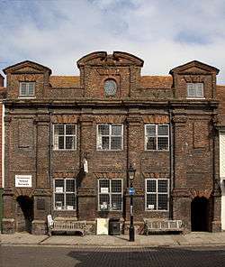
Historically Rye was an independent Borough granted rights of governance under its charter of 1289, with its own appointed Mayor and chosen Jurats (magistrates). These independent powers were terminated by the Local Government Act of 1973 and, although officially considered to be a civil parish,[20] Rye's governing body – because of its history – is that of a Town Council. That Council has one electoral ward, electing 16 members, one of whom then is elected Mayor of Rye.[21] In the Townhall[22] there is an unbroken list of the Mayors of Rye going back to the 13th century. There are also two gruesome relics of Rye's violent past: the gibbet cage which was famously used to display the hanged body of the murderer John Breads in 1742, and the pillory last used in 1813 in the case of a local publican who assisted the escape of the French General Phillipon. The current Mayor (2016) is Cllr Jonathan Breeds.[23]
Apart from the Town Council, local government is exercised by Rother District Council (RDC), with its headquarters in Bexhill-on-Sea, and East Sussex County Council, based in Lewes. The Rye ward returns two councillors to RDC.
Since 1983 Rye has been part of the parliamentary constituency of Hastings and Rye, prior to which it had its own seat. The current Member of Parliament is Amber Rudd of the Conservative Party.
Geography
Rye stands at the point where the sandstone high land of the Weald reaches the coast. The medieval coastline (see map above), with its large bay, enabled ships to come up to the port. The original course of the River Rother then reached the sea at Romney to the northeast. Storms in the English Channel in the thirteenth century, coupled with reclamation of the bay, brought huge quantities of gravel through longshore drift along the coast, blocking the port entrance. The course of the river has also changed over the centuries so that Rye now stands on the river at the point of its confluence with the River Tillingham and the River Brede, whereas the river flows southward into Rye Bay. River Rother and the environs of Rye Harbour are managed and maintained by the Environment Agency.[24] The Rivers Brede and Rother also form part of the Royal Military Canal between Winchelsea and Iden Lock. The town is part of the remotest and least populated area of southeastern England, on the edge of Romney Marsh and within three kilometres of the coast.
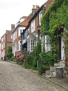
A part of the town, but only a minority of the housing stock, lies on the original rocky heights (the Citadel) and contains the historic buildings including St Mary's parish church, the Ypres Tower (part of the Town Wall), Lamb House and many of the houses on Mermaid Street, Watchbell Street, and Church Square. The main road skirts the town to the south after crossing the river; Winchelsea Road leads to New Winchelsea Road, formerly Royal Military Road, which runs parallel to the River Brede before leaving the town boundary. The houses along New Winchelsea Road date from the 1930s, built on the excavations from the Royal Military Canal. The gardens run down to the river, with fishing and boating rights. Most of Rye's inhabitants live outside the Citadel area.
Economy
Rye, over the centuries has successively been an entrepôt port, a naval base, a fishing port, an agricultural centre and a market town. Today, more than anything, Rye depends on its tourist appeal, which attracts traffic from all over the world. The old part of the town within the former town walls now offers a wide range of antique shops, art galleries, gift shops, restaurants and a guitar shop in Lion Street near the church.
Since World War II, the town has also become a renowned centre for ceramics.[25]
Apart from its tourist base, Rye continues to operate as a port. There has been considerable investment in facilities for both the fishing fleet berthed at Rye and the commercial wharves at Rye Harbour. Rye fishing boats are code-lettered RX (from "Rye, Sussex"; this registration is also used by the Hastings fishing fleet) and land fish daily. Some is sold at the quayside though most is sold through the great regional market in Boulogne.
At Rye Harbour, the Rastrums Wharf (which was renovated in the 1980s) has the capacity to take large ships up to 80 metres (260 ft) on a high tide.
Rye also is an important yachting base, offering the only safe haven for many miles in either direction along this section of Channel coast. Yachts may currently moor either at Rye Harbour or at the Strand Quay at the edge of the town.[26] There have been numerous plans proposed for a modern yacht marina to be built at Rye, but each has foundered on economic or planning grounds.
Transport
At the latter end of the 18th century, Rye was connected to the Turnpike Trust system of roads. One of these, the Flimwell Turnpike, took passengers towards London;[27] the second ran from Hastings eastwards through the town. These two roads are now the A268 and the A259. In the 1980s and 1990s there were proposals to bypass the A259 route around Rye but these met with local opposition and never received any priority in the building programme.
In addition to the hourly 100/101 Dover-Hastings Stagecoach long-distance coach service, there are buses connecting Rye with other towns and villages, including Tenterden, Hastings and Tunbridge Wells.[28]
Rye has a railway station on the "Marshlink" line between Hastings and Ashford. This now provides an hourly service from Brighton to Ashford International connecting with Eurostar services to Paris Gare du Nord and the high-speed Class 395 service to London St Pancras. Gatwick Airport may be reached by rail via Eastbourne or Lewes.
Before World War II there was a Summer steamship service from Rye to Boulogne. Rye was also the terminus for the prewar Rye & Camber Tramway, built to serve golf courses and Camber Sands, closed to the public at the outbreak of World War II, never reopened and scrapped in 1947.
Several long-distance footpaths can be joined by walkers in the town. The Saxon Shore Way which starts at Gravesend, Kent and traces the coast as it was in Roman times, passes through Rye en route to Hastings; the 1066 Country Walk leads from Rye to Pevensey; the High Weald Landscape Trail goes to Horsham; and the Royal Military Canal Path follows that waterway to Hythe.
Education
Rye College (formerly called Thomas Peacocke Community College, and before that Thomas Peacocke School) is a secondary school in Rye. Rye Studio School opened in September 2013 for 14- to 19-year-olds. The two primary schools, Tilling Green Infant School and Freda Gardham Community School, were replaced by a new school, Rye Primary, adjacent to the secondary institution, in September 2008. The original Rye Primary School was situated just off Ferry Road near the railway crossing.
Places of worship
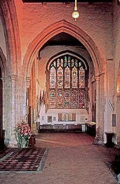
Past and present places of worship in Rye include St Mary's, the Anglican parish church with Norman origins;[29] St Anthony of Padua Roman Catholic church, rebuilt in 1929; a 1909 Baptist chapel in Cinque Ports Street, replacing the Rye Particular Baptist Chapel of 1754 (which itself stood on the site of an older Quaker meeting house); former Congregational and Independent churches; and a Methodist chapel.[30]
Amenities
Rye is a local commercial centre for the Romney Marsh and Walland Marsh area as well as being a tourist spot. Rye Farmers' Market[31] takes place on Strand Quay every Thursday morning. Rye has a well-established reputation as a centre for shops trading antiques, collectors' books and records, and has many art galleries selling works by local artists and potters with changing exhibitions throughout the year.
Rye's general weekly market takes place on the marketplace car park by the station every Thursday. Until the Foot-and-Mouth disease crisis in 2001 (which closed all livestock markets in England) there were frequent livestock sales at Rye.
Rye Castle Museum is located on two sites, in East Street and at the Ypres Castle.[6] One of the tourist websites includes a picture tour of the town[32] Rye Art Gallery was established as a Trust in the early 1960s. Located at 107 High Street it provides a focus for contemporary visual art, which it exhibits alongside heritage artworks from its Permanent Collection.
Rye also stands at the centre of a network of nature reserves, some of national importance. The Rye Harbour SSSI lies to the south and includes the Rye Harbour Nature Reserve.[33][34] The neighbouring Pett Levels and Pools, and the Pannel Valley nature reserve are accessible via Winchelsea and Winchelsea Beach a few miles to the west, whilst Scotney Lake lies just off the Lydd road and the RSPB reserve at Dungeness lies a few miles further to the east[35] with the Bird Observatory located in the old lighthouse.[36]
The recent redevelopment of the Rye wharf for the RX fishing fleet has provided modern amenities for the landing and storage of fish. Most is sold wholesale through the regional market in Boulogne, though there is a trend for Rye to develop as a gastronomic centre in the style of Newquay or Padstow, featuring the use of fresh local produce from the sea. The annual "Rye Bay Scallops Festival"[37] which takes place each year in February was first proposed by the then Chair of the Chamber of Commerce, Kate Roy, as a means of promoting the "Rye Bay Catch". Excellent scallops (and flatfish such as sole, plaice and dabs) are to be had in Rye Bay because of the shallow and relatively sheltered water.
Every year in September Rye hosts its annual two-week "Arts Festival" which attracts a world-class series of performers in music, comedy and literature[38]
On the second Saturday after 5 November the "Bonfire Boys"[39] stage their annual torch-lit parade through the streets of the town, supported by visiting Bonfire Societies from all over the Sussex Bonfire Societies Confederation. This is followed by a "gurt 'normous bonfire" where the chosen "effigy" of the year is ceremoniously blown-up, and a spectacular firework display. This event typically attracts over 10,000 visitors to the town, and results in the town's roads, and the main roads to London, Hastings and Ashford, being clogged up and closed to traffic from the early evening onwards.
Sport and leisure
Rye has a Non-League football club Rye United F.C. who play at The Salts.
Rye in literature
There are various mentions of the town by famous travel writers between the 16th and 18th centuries, although not all mentions were good. Sir Robert Naunton (1563–1635) mentions it in his book Travels in England, published sometime between 1628 and 1632: he calls Rye a "small English seaport"; shortly after his arrival he takes post-horses for London, travelling via Flimwell. Daniel Defoe (1660–1731) describes the state of the harbour and its approaches, saying that "Rye would flourish again, if her harbour, which was once able to receive the royal navy, cou'd be restor'd … " but that he thought it very doubtful that large ships would be able to use the port again.[40] William Cobbett (1763–1835) simply mentions it in passing, saying that this area (that including the Romney Marsh) would be most likely to be where the French invaders might land. According to Norman Wright's book "The Famous Five: Everything you ever wanted to know", it was Rye and the Romney Marsh that inspired Enid Blyton to write "Five go to Smuggler's Top" (1945). In 1969 Malcolm Saville published an entry in his Lone Pine series of children's adventure novels titled Rye Royal set largely in Rye.
Rye has produced and attracted many fiction writers, some of whom lived at Lamb House, one of the town's historic residences and now owned by the National Trust[41] They include Henry James (1843–1916), the American novelist, who was resident between 1898 and 1916; Rumer Godden (1907–98), the Anglo-Indian novelist; and E.F. Benson (1867–1940), the English novelist. Both the House and the town feature prominently in Benson's Mapp and Lucia novels, as Mallards House and Tilling respectively. In the mid 1980s, Rye was used as a filming location by LWT for its adaptation of the Mapp and Lucia novels. A BBC adaptation of Mapp and Lucia was filmed in Rye in the summer of 2014.[42] The post-Monty Python film Yellowbeard also had a few scenes filmed on the cobbled street. John Christoper (Samuel Youd) wrote many of his novels including the 'Death of Grass' whilst a resident, as did the popular children's author John Ryan, creator of the Captain Pugwash books and "Sink Port' is a thinly disguised fictional version of the town and pun on 'cinque port'. The feature film Captain Horatio Hornblower R.N. was filmed in Mermaid Street. It starred Gregory Peck and was made in 1951. Mermaid Street serves as Hornblower's wife and mother's house in Portsmouth.
People of Rye
Other residents of the town and environs have included:
- Conrad Aiken (1889–1973), American writer. Aiken's former home, Jeake's House, is now a guest house.
- Joan Aiken (1924–2004), children's author, daughter of Conrad Aiken
- Geoffrey Bagley (1901–1992), Canadian war artist who settled in Rye post war and then worked to preserve the town's historic mementos and places.[43]
- Tom Baker (born 1934), British actor, best known for playing the Doctor in Doctor Who 1974–1981.
- Edward Burra (1905–1976), painter, draughtsman and printmaker, born near Rye and lived in the town from time to time in the 1920s and 1930s
- Paul Nash (1889–1946), World War I artist, lived in East Street in the 1930s
- John Christopher (1922–2012), science fiction author. The 1980s British television series based on his trilogy, The Tripods, was filmed near his house.
- Tom Chaplin (born 1979), singer of the band Keane
- Monica Edwards (1912–1998), children's author who lived at Rye Harbour and set her Romney Marsh novels in the area, renaming Rye Dunsford.
- John Fletcher (1579–1625), Jacobean playwright and solicitor.
- Radclyffe Hall (1880–1943), seminal lesbian writer.
- Wendy Law-Yone Burmese writer who current lives in London and Rye[44]
- Sir Paul McCartney (born 1942), musician and former Beatle. McCartney's children attended the local schools in Rye.
- Spike Milligan (1918–2002), comedian, writer, musician, poet, playwright and vice-president of the Rye Rugby Club.
- John Ryan (1921–2009), although born in Edinburgh, this British author/cartoonist famed for his TV cartoon Captain Pugwash, was a resident of Rye.
- Malcolm Saville (1901–1982), author of nearly 80 children's books, largely thrillers and adventure stories. Saville was the creator of the Lone Pine series of books, a number of which were set in Rye, including The Gay Dolphin Adventure and Rye Royal.
- Baron Saville of Newdigate (born 1936) Chair of the "Bloody Sunday" enquiry and nephew of Malcolm Saville, attended Rye Grammar School (1947–1953). The new Rye Studio School's dance theatre is named after him.
- Admiral Sir Aubrey Smith (1872–1957) lived in Rye at Iden Cottage[45]
- Russell Thorndike (1885–1972), who set his Dr Syn novels about smuggling on the marshes.
- Philippa Urquhart (born 1940), British actress.
- Sir Anthony van Dyck (1599–1641), did several drawings of the town, unusually detailed for him, and probably done to pass the time until a ship to the continent arrived .
- Some ancestors of Jamaican reggae artist Bob Marley (1945–1981) reportedly hail from Rye; great-grandfather Frederick, was born in the town in 1820.[46]
References
- 1 2 "East Sussex in Figures". East Sussex County Council. Retrieved 26 April 2008.
- ↑ "Rye (East Sussex, South East England, United Kingdom) - Population Statistics and Location in Maps and Charts".
- ↑ Paul Theroux found it "museum-like in its quaintness... It had the atmosphere of a china-shop." (Theroux, The Kingdom by the Sea, 1983:53f.)
- ↑ "Visit Rye, East Sussex - Visit1066Country.com".
- ↑ Maritime History of Rye. Douwe Brink
- 1 2 "Rye Castle Museum - 3 East Street and the Ypres Tower".
- ↑ BBC News Tonnes of pigeon faeces removed from Rye's Landgate Arch (26 February 2015)
- ↑ 14th century murage
- ↑ The Gift of the Sea. Anne Roper
- ↑ History of Rye Harbour
- ↑ "Rye Harbour Lifeboat Station".
- ↑ recorded by the British folk band Meet on the Ledge, and by the American folk duo William Pint and Felicia Dale
- ↑ Dan Cruickshank (5 November 2009). "Napoleon, Nelson and the French Threat". BBC. Retrieved 7 March 2010.
- ↑ Sussex Police Forces;A pictorial history from 1836 to 1986 by Neville Poulsom, Mike Rumble and Keith Smith (Middleton Press) (1987) ISBN 0 906520 436
- ↑ Poulsom, Rumble and Smith (1987) op cit. This station closed in 1967 with the opening of a new station in Cinque Port Street
- ↑ Poulsom, Rumble and Smith (1987) op cit
- ↑ Hastings, Max, p.66, All Hell Let Loose, Harper Press, London (2011)
- ↑ P. C. Spierenburg, A History of Murder: Personal Violence in Europe from the Middle Ages to the Present (Cambridge: Polity, 2008), p. 261
- ↑ John Collard – A maritime History of Rye
- ↑ "Rye Town Council : The Council". ryetowncouncil.gov.uk.
- ↑ "Rye Town Council : Terms of Reference". ryetowncouncil.gov.uk.
- ↑ "Rye Town Council : Town Hall". ryetowncouncil.gov.uk.
- ↑ "New Rye mayor appointed during traditional ceremony". ryeandbattleobserver.co.uk.
- ↑ "Rye Harbour". Environment Agency.
- ↑ "Page not found - Rye Society".
- ↑ Moorings at Rye
- ↑ William Holloway (1847). The History and Antiquities of the Ancient Town and Port of Rye. Rye: J.R. Smith. p. 462. OCLC 59487213
- ↑ "List Transport Services".
- ↑ Nairn, Ian; Pevsner, Nikolaus (1965). The Buildings of England: Sussex. Harmondsworth: Penguin Books. p. 594. ISBN 0-14-071028-0.
- ↑ Elleray, D. Robert (2004). Sussex Places of Worship. Worthing: Optimus Books. pp. 47–48. ISBN 0-9533132-7-1.
- ↑ Rye Farmers' Market
- ↑ "Pictures of Rye".
- ↑ Rye Bay Wildlife
- ↑ "Wild Rye - Discover Our Wetland Wildlife".
- ↑ "Dungeness".
- ↑ "Dungeness Bird Observatory".
- ↑ "Rye Bay Scallop Week - Sat 18th – Sun 26th Feb 2017".
- ↑ "Rye Arts Festival".
- ↑ "Rye & District Bonfire Society - Saturday 12 November 2016".
- ↑ "Vision of Britain - Daniel Defoe - Letter 2, Part 2: Canterbury and Sussex".
- ↑ National Trust:Lamb House
- ↑ "BBC One announces adaptation of EF Benson's Mapp And Lucia". BBC. 28 February 2014. Retrieved 4 April 2014.
- ↑ "Geoffrey Bagley - Legion Magazine". 11 October 2010.
- ↑ "Wendy Law-Yone".
- ↑ 'SMITH, Admiral Sir Aubrey Clare Hugh' in Who Was Who 1951–1960 (London: A. & C. Black, 1984 reprint, ISBN 0-7136-2598-8)
- ↑ "Ancestry of Bob Marley".
External links
| Wikivoyage has a travel guide for Rye. |
- Rye Harbour Nature Reserve
-
 Media related to Rye, East Sussex at Wikimedia Commons