Aberporth
| Aberporth | |
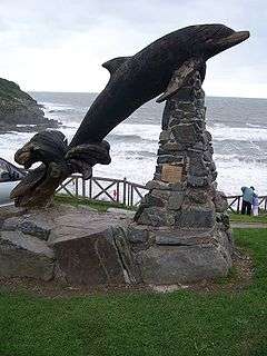 Leaping Dolphin sculpture in the centre of Aberporth |
|
 Aberporth |
|
| Population | 2,374 (2011)[1] |
|---|---|
| OS grid reference | SN2549251448 |
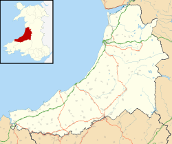
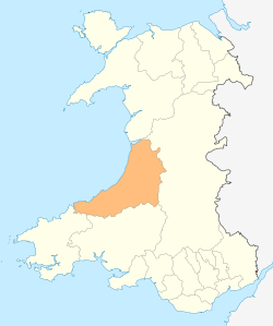
| Principal area | Ceredigion |
| Ceremonial county | Dyfed |
| Country | Wales |
| Sovereign state | United Kingdom |
| Post town | Cardigan |
| Postcode district | SA43 2 |
| Police | Dyfed-Powys |
| Fire | Mid and West Wales |
| Ambulance | Welsh |
| EU Parliament | Wales |
| UK Parliament | Ceredigion |
| Welsh Assembly | Ceredigion |
|
|
Coordinates: 52°08′00″N 4°33′00″W / 52.133333°N 4.55°W

Aberporth is a community and large village in Ceredigion on the west coast of Wales. The population was 2,485 in 2001,[2] 49% of whom spoke Welsh, according to the 2001 Census, reducing slightly to 2,374 at the 2011 Census. Its beach has earned Blue flag status.[3]
Location
The village lies at the southern end of Cardigan Bay about six miles north of Cardigan and ten miles south of New Quay approximately two miles west of the A487, on the B4333 and about 2 miles from Tresaith. It is on the Ceredigion Coast Path, part of the Wales Coast Path.
History
In the 16th century, Aberporth was a subsidiary landing point for the port of Cardigan. Boats, nets and salt for preserving were brought in from Ireland. It developed rapidly in the late 17th and early 18th centuries as local people began to take part in the maritime trade. It became a very active port with the northernmost of the two beaches extending into the river valley and provided a safe anchorage. Limekilns, coalyards and warehouses were built on its south shore.[4]
Aberporth developed into one of the main centres of the herring fishing industry in Wales. Drifting and netting were both employed and at one time at least 20 full-time herring smacks, a type of traditional fishing boat, went to sea regularly. The industry persisted until the beginning of the First World War when fish stocks declined.[5] Crab and lobster fishing continues on a small scale to this day.
Amenities
The main industries are Ministry of Defence work at the QinetiQ missile range, and tourism.
Its Anglican parish church is St. Cynwyl's within the Church in Wales. The church is open daily and visitors are welcome to attend services. It is a small church that was renovated in 1857, but has decayed in the last few decades and modernisation is long overdue. Although the congregation is mainly elderly there is an active children's club associated with the primary school.
ParcAberporth is located near here, and has become a noted centre of excellence in the sectors of defence, aerospace and in particular the developing technology of unmanned aerial vehicles (UAVs). ParcAberporth is linked with the world class research facilities at the nearby University of Wales, Aberystwyth.
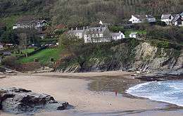
The picturesque village overlooks two sandy beaches and is one of Ceredigion's favourite holiday destinations, proving popular with tourists throughout Western Europe. Rock pools are exposed at low tides and the cliff top walks along the Ceredigion Coast offer extensive views.
Bottlenose dolphins are seen frequently close to shore. In 2006 orcas and harbour porpoises have also been seen but such sightings are rare. Even rarer was a turtle seen in 2005. Sunfish and basking sharks are often seen offshore in the summer.
Aberporth is a popular recreational fishing village in the summer and is also popular with divers and boating people. It has two good beaches and has been awarded a blue flag for its beaches several years running due to the high water quality found in this area.
Near Aberporth lies Aberporth Airport (West Wales Airport), now a centre for drone research.
Education
In 1834, Aberporth School was established, and had 31 pupils in 1836. In 1854, a building with a capacity of 110 pupils was built, and the average attendance in 1904 was 68. It was a national school until 1926, when it changed to a Church of England school. In 1915, a council school was established.[6]
The primary school in Aberporth is Ysgol Gymunedol Aberporth.[7]
Weather Station
The Met Office has a weather station at Aberporth.[8] It is one of the 22 locations whose reports are included in the BBC Shipping Forecast. Data is available going back to 1941.[9]
Typically, less than 3 days[10] of the year will reach 25.1 °C (77.2 °F) or above, the warmest of which should rise to 26.8 °C (80.2 °F)[11] - The highest temperature recorded at Aberporth was 32.7 °C (90.9 °F), during July 2006.[12] On average 18.3 nights will report air frost and the coldest night of the year should fall to −4.5 °C (23.9 °F).[13] The lowest recorded temperature was −9.9 °C (14.2 °F), during January 1963[14]
Rainfall averages around 870mm a year, with at least 1mm falling on 143.5 days.
| Climate data for Aberporth 133m asl, 1971-2000, Extremes 1960- | |||||||||||||
|---|---|---|---|---|---|---|---|---|---|---|---|---|---|
| Month | Jan | Feb | Mar | Apr | May | Jun | Jul | Aug | Sep | Oct | Nov | Dec | Year |
| Record high °C (°F) | 13.4 (56.1) |
15.2 (59.4) |
21.0 (69.8) |
25.6 (78.1) |
26.6 (79.9) |
31.5 (88.7) |
32.7 (90.9) |
31.5 (88.7) |
25.2 (77.4) |
22.0 (71.6) |
17.0 (62.6) |
14.1 (57.4) |
32.7 (90.9) |
| Average high °C (°F) | 7.3 (45.1) |
7.3 (45.1) |
8.7 (47.7) |
10.6 (51.1) |
13.7 (56.7) |
15.9 (60.6) |
18.0 (64.4) |
18.1 (64.6) |
16.1 (61) |
13.2 (55.8) |
10.0 (50) |
8.3 (46.9) |
12.3 (54.1) |
| Average low °C (°F) | 2.9 (37.2) |
2.6 (36.7) |
3.8 (38.8) |
4.9 (40.8) |
7.5 (45.5) |
10.0 (50) |
12.2 (54) |
12.3 (54.1) |
10.7 (51.3) |
8.4 (47.1) |
5.6 (42.1) |
3.9 (39) |
7.1 (44.8) |
| Record low °C (°F) | −9.9 (14.2) |
−7.5 (18.5) |
−6.6 (20.1) |
−2.0 (28.4) |
0.1 (32.2) |
1.7 (35.1) |
5.6 (42.1) |
5.5 (41.9) |
3.3 (37.9) |
−0.9 (30.4) |
−5.0 (23) |
−6.0 (21.2) |
−9.9 (14.2) |
| Average precipitation mm (inches) | 88.5 (3.484) |
62.7 (2.469) |
63.7 (2.508) |
50.7 (1.996) |
48.2 (1.898) |
61.1 (2.406) |
49.2 (1.937) |
68.2 (2.685) |
75.7 (2.98) |
104.2 (4.102) |
98.3 (3.87) |
99.2 (3.906) |
870.2 (34.26) |
| Mean monthly sunshine hours | 54.6 | 74.0 | 109.7 | 168.6 | 213.6 | 190.5 | 198.7 | 184.8 | 141.0 | 100.1 | 63.3 | 45.6 | 1,544.5 |
| Source: Met Office[15] | |||||||||||||
References
- ↑ "Community and Ward population 2011". Retrieved 10 May 2015.
- ↑ Office for National Statistics : Census 2001 : Parish Headcounts : Ceredigion
- ↑ Blue Flag beaches in Wales Retrieved 18 December 2011
- ↑ Jenkins, J. Geraint. Ceredigion: Interpreting an Ancient County. Gwasg Careg Gwalch (2005) pg. 51.
- ↑ Jenkins, J. Geraint. Ceredigion: Interpreting an Ancient County. Gwasg Careg Gwalch (2005) pg. 52.
- ↑ "Ref:Aberporth". Ceredigion Archives - School Records. Ceredigion County Council. Archived from the original on 24 July 2011. Retrieved 9 June 2011.
- ↑ EduBase details for 400607
- ↑ Met Office stations
- ↑ Met Office - Aberporth data
- ↑ ">1971-2000 average >25c days". Retrieved 2011-09-26.
- ↑ ">1971-2000 average warmest day". Retrieved 2011-09-26.
- ↑ ">2006 Maximum". Archived from the original on 2011-06-29. Retrieved 2011-09-26.
- ↑ ">1971-2000 average coldest night". Retrieved 2011-09-26.
- ↑ ">1963 Minimum". Retrieved 2011-09-26.
- ↑ "Aberporth 1971-2000 averages". Met Office. Retrieved 26 Sep 2011.
External links
| Wikimedia Commons has media related to Aberporth. |
| Wikivoyage has a travel guide for Aberporth. |
- www.geograph.co.uk : photos of Aberporth and surrounding area
- Information on the Ceredigion Tourism website
- Tourist accommodation in nearby Tresaith
- History of sounding rocket launches from Aberporth facility 1959-1972
- Map of Facilities around Tresaith and Aberporth
- grid reference SN260514