River Teifi
| River Teifi (Afon Teifi) | |
 Llyn Teifi, the source of the Teifi | |
| Country | Wales |
|---|---|
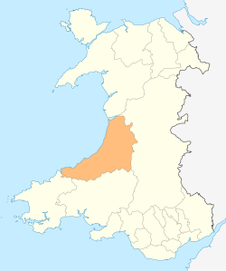
| Counties | Ceredigion, Carmarthenshire, Pembrokeshire |
| Tributaries | |
| - left | Tyweli, Cych |
| - right | Dulas, Clettwr, Ceri |
| Source | |
| - location | Llyn Teifi |
| - elevation | 455 m (1,493 ft) |
| - coordinates | 52°17′30″N 3°47′24″W / 52.2918°N 3.7900°W |
| Mouth | |
| - location | Cardigan Bay |
| - elevation | 0 m (0 ft) |
| - coordinates | 52°06′11″N 4°41′20″W / 52.103°N 4.689°WCoordinates: 52°06′11″N 4°41′20″W / 52.103°N 4.689°W |
| Length | 117 km (73 mi) [1] |
| Basin | 1,008 km2 (389 sq mi) [2] |
| Discharge | for Glan Teifi |
| - average | 29.1 m3/s (1,028 cu ft/s) [3] |
| - max | 373.6 m3/s (13,194 cu ft/s) |
 Mouth of the Teifi shown within Wales | |
| Wikimedia Commons: River Teifi | |
The River Teifi (Welsh: Afon Teifi pronounced [ˈtəɪvɪ]) forms the boundary between the counties of Ceredigion and Carmarthenshire in south-west Wales for most of its length, and the boundary between Ceredigion and Pembrokeshire for the final 3 miles (5 km) of its total length of 73 miles (117 km). It flows into the sea below the town of Cardigan.
Geography
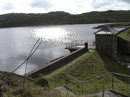
The Teifi has its source in Llyn Teifi, one of several lakes known collectively as the Teifi Pools. These are situated towards the north of the county of Ceredigion; the source is in the Cambrian Mountains at 455m. This wide area of Mid-Wales, with a very sparse population, is part of what is sometimes called the "desert of Wales". The river flows past Strata Florida Abbey and then through Pontrhydfendigaid before reaching the main river valley floor. Here it passes through one of the great raised mires of Britain, Gors Goch Glan Teifi, also known as Tregaron Bog. From here the river descends through pastures and bogs forming meanders on farmland below. Several small tributaries join from the valley with gorges, rocky and tree-lined sections also in the area.
Over the next 30 miles (50 km), the Teifi meanders generally south-west in a gentle arc, passing through the towns and villages of Tregaron, Llanddewi Brefi, Cwmann, Lampeter, Llanybydder, Llandysul, Newcastle Emlyn, Cenarth, Llechryd and Cardigan. The river becomes tidal below Llechryd and descends into Cardigan through the steep-sided Cilgerran Gorge. Below Cardigan, the river broadens into a wide estuary, passing St Dogmaels and the seaside resort of Poppit Sands on its southern bank and Gwbert on its northern bank before entering the sea in Cardigan Bay.
On the lower parts of the river the wildlife is rich. There is a large variety ranging from crowfoot river plants to Atlantic salmon as well as otters, wetland birds and multi fruited river moss. There have also been sightings of bottle-nosed dolphins where the river opens into the estuary and flows into Cardigan Bay.[4]
Afon Tywi at 120 km (75 mi) and Afon Teifi at 117 km (73 mi) are the longest rivers wholly in Wales.[5]
The river is susceptible to flooding and there were some heavy floods in 2007 and 2008. If the swollen river is backed up by a high tide, flooding can occur in Cardigan[6] and as far up river as Llechryd.[7] The most recent flooding was in December 2015.[8]
Geology and landscape
The Teifi and its tributaries are underlain by ancient Ordovician and Silurian mudstones which have been extensively glaciated during the ice ages. The resultant landform is one of gently rolling hills supporting a range of agriculture in which dairy and sheep farming dominate. Ceredigion had the reputation of supplying London with its milk in the 19th century. The landscapes of the Teifi valley are very attractive and the Teifi is considered by many to be one of the most beautiful rivers in Wales.
Teifi Pools, the source of the Teifi, are a series of small lakes left by past glacial activity. The lakes are upland and acid in nature. Some have been enlarged by damming and now provide a source of drinking water. The very extensive raised mire above Tregaron acts as a huge sponge at the head of the river and evens out extremes in flow.
Rapids and waterfalls are uncommon but the examples at Henllan and, especially at Cenarth, are noteworthy and have been extensively photographed and painted because of the beauty of the landscape. A dramatic painting of the falls was made by Frank Miles and is now at Nottingham City Museum. Miles's father inherited Cardigan Priory from his father, Philip John Miles, but lived in Nottinghamshire as Rector of Bingham.[9]
The gorge between Llechryd and Cilgerran has a special brooding quality. Few visitors stray into the gorge and the river winds its way almost silently between the densely wooded sides with their distinctive under-storey flora of sedges.
SSSI
| Site of Special Scientific Interest | |
| Area of Search | Ceredigion |
|---|---|
| Grid reference | SN5153250832 |
| Interest | Biological and Geological |
| Area | 778.18 ha |
| Notification | 1997 |
Afon Teifi is a Site of Special Scientific Interest (or SSSI) in Ceredigion, Wales. It is protected by law and has been designated as a Site of Special Scientific Interest since December 1997 in an attempt to protect rare or unique features or species within it.[10] The site has an area of 778.18 hectares and is managed by Natural Resources Wales. This SSSI has been notified as being of both geological and biological importance.
Hydrology

The catchment of the river is estimated to be 1,008 square kilometres (389 sq mi)[2] yielding an average flow at Glan Teifi of 29.126 m³/s.[3] The maximum recorded flow between 1959 and 2011 was 373.6 m³/s on 18 October 1987.[3] The average annual rainfall varies from 1,552 millimetres (61.1 in) in the upper catchment to 1,176 millimetres (46.3 in) in the lower catchment, which is higher than the average for United Kingdom at 1,101 millimetres (43.3 in).[11]
Culture and history
The Teifi valley has been inhabited since pre-history. There are many remains of Iron Age and Stone age man including Cromlechs (burial chambers) and standing stones. The remains of a medieval abbey stand at Strata Florida with some excellent examples of encaustic tiles on the floors. The river flows near to the Lampeter campus of the University of Wales, Trinity Saint David, its predecessor, the University of Wales, Lampeter (est. 1822) having been the oldest university established in Wales.
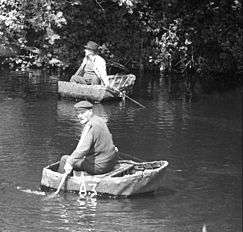
Between Cenarth and Cardigan, there is an ancient tradition of fishing and travel using coracles – very simple light-weight boats made of bent sticks covered with waterproofed hide or skins. These are paddled by a single oar used at the front of the craft which requires great skill. The principal use for coracles is for salmon fishing using nets. This form of fishing is now very tightly controlled and the right to fish in this way is passed down from father to son. There is also an age-old tradition of illegal salmon and sea-trout fishing in the lower Teifi. In 1188 Giraldus Cambrensis observed what is thought to have been the last colony of European Beaver in England or Wales on the Teifi.
Attractions

- Cardigan Castle
- Cenarth Falls
- Cilgerran Castle
- Coedmor National Nature Reserve
- Teifi Marshes Wildlife Trust of South and West Wales Nature Reserve, Cardigan [12]
- Teifi Valley Railway, a 2-foot gauge steam railway which operates on the GWR part of the Carmarthen and Cardigan Railway between Llandysul and Newcastle Emlyn.[13]
References
- ↑ "River Teifi". Countryside Council for Wales. Retrieved 4 February 2014.
- 1 2 "First Water Resources Survey : Report", South West Wales River Authority, Published 1970, Page 41; Table 1
- 1 2 3 "62001-Teifi at Glanteifi". The National River Flow Archive. Centre for Ecology & Hydrology. Retrieved 4 February 2014.
- ↑ "River Teifi SAC". Archived from the original on February 26, 2014. Retrieved 6 June 2014.
- ↑ Davies, John; Jenkins, Nigel; Baines, Menna; Lynch, Peredur I., eds. (2008). The Welsh Academy Encyclopaedia of Wales. Cardiff: University of Wales Press. pp. 894 & 855. ISBN 978-0-7083-1953-6.
- ↑ "30 homes flooded in Cardigan after "worst ever" flood". Carmarthen Journal. 3 January 2014. Retrieved 30 January 2016.
- ↑ "Resident marooned in home after River Teifi bursts banks". BBC. 21 December 2015. Retrieved 30 January 2016.
- ↑ "This is the scene in Pembrokeshire as further flood warnings issued across Wales". Wales Online. 22 December 2015. Retrieved 30 January 2016.
- ↑ "BBC - Your paintings - Salmon Leap, Cenarth Falls, Cardiganshire". Retrieved 30 January 2016.
- ↑ "Countryside Council for Wales website (Natural Resources Wales since 2013)". Retrieved 6 June 2014.
- ↑ "Climate tables UK 1961-90". Met Office. Retrieved 10 May 2013.
- ↑ "Teifi Marshes, Wildlife Trust Nature Reserve, Wales". first-nature.com.
- ↑ "The Teifi Valley Railway in Ceredigion West Wales". walesrails.co.uk.