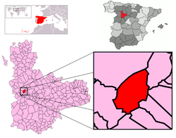
Adalia, Valladolid
| Adalia | |
|---|---|
 Adalia in Valladolid Province | |
| Coordinates: 41°38′55″N 5°7′8″W / 41.64861°N 5.11889°WCoordinates: 41°38′55″N 5°7′8″W / 41.64861°N 5.11889°W | |
| Government | |
| • Mayor | Jesús Fernández |
| Area | |
| • Total | 16.19 km2 (6.25 sq mi) |
| Elevation | 784 m (2,572 ft) |
| Population (2011) | |
| • Total | 58 |
| • Density | 3.6/km2 (9.3/sq mi) |
| Area code(s) | 983 |
Adalia is a village in Valladolid, Castile-Leon, Spain. The municipality covers an area of 16.19 square kilometres (6.25 sq mi) and as of 2011 had a population of 58 people.[1]
Geography
This municipality is located in a vale. It belongs to the Montes Torozos shire, and borders San Cebrián de Mazote, Barruelo del Valle, Villasexmir, San Salvador, Gallegos de Hornija, Vega de Valdetronco and Mota del Marqués municipalities. The Retortero and Darzuela streams run across it, and its maximum altitude lies at mount Atalaya, with 830m.
History
The village was formerly walled. It was owned by the bishop of Palencia and the Order of San Juan. It was named Adella by the Order. The main activity two centuries ago was the harvesting of wheat and barley, as well as canvas bleaching.
References
See also
- Towns in Spain
