Adams Avenue Parkway
| Adams Avenue Parkway | |
|---|---|
|
Adams Avenue Parkway (highlighted in red) | |
| Route information | |
| Maintained by Adams Avenue Turnpike, LLC | |
| Length: | 0.5 mi[1] (0.8 km) |
| Existed: | June 27, 2001[2] – present |
| Major junctions | |
| South end: |
|
| North end: |
|
| Highway system | |
| |
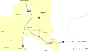
The Adams Avenue Parkway is a one-half-mile-long (800 m) private toll road in the U.S. state of Utah connecting U.S. Route 89 (US-89) to Interstate 84 (I-84) near Washington Terrace, Utah. The roadway opened in 2001 at a cost of $8.9 million and was created after decades of requests by locals to connect the existing Adams Avenue to I-84. This allowed commuters to bypass the rest of US-89 through Washington Terrace to I-84.
Route description
The main access to the south end of the parkway is from I-84 at exit 85, a pre-existing diamond interchange with a local road in South Weber named 475 East. The four-lane, 35 mph (56 km/h) toll road, which has no shoulders or sidewalks, begins at Cottonwood Drive, I-84's north side frontage road. It immediately crosses a bridge over the Weber River (the Davis-Weber County line and north limit of South Weber) and the Union Pacific Railroad's Evanston Subdivision (the south limit of Washington Terrace). The parkway then curves northwest and climbs out of the Weber River's floodplain with a maximum grade of nine percent,[3] reaching the toll plaza most of the way up the hill.[1]
After one intersection with 5900 South, which presently serves only the toll road company's headquarters and a single commercial building, private maintenance gives way to a four-lane city street with sidewalks just shy of 5800 South.[4] The roadway continues northeasterly to the top of the hill near 5600 South, where pre-existing Adams Avenue (500 East) heads north, passing the Ogden Regional Medical Center to an intersection with Washington Boulevard (US-89) on the Washington Terrace-South Ogden border. Adams Avenue continues through South Ogden and into Ogden as a minor street one block east of US-89, with a gap near 4600 South and more north of downtown Ogden.[1][5] In 2006 approximately 1,400 cars traveled the parkway on an average weekday.[6]
Tolls
Tolls are collected in cash or via an ExpressCard account, a prepaid system that offers a discount for a $10 deposit to the account. The current toll is $1 in each direction for two-axle vehicles and $0.50 for each additional axle.[7] Previously emergency vehicles (ambulances) were not charged a toll, however beginning July 3, 2003,[8] they must pay the standard $1 toll. To allow quick passage through the toll barrier, these vehicles pay through a charge account. The Utah Department of Transportation worked out an agreement during local road construction for four days in 2003 to allow commuters to use the parkway free of charge.[9]
History
The parkway was opened in 2001 after just under a year of construction and almost two decades of community requests.[2][10] Local residents led by Doug and Bruce Stephens urged the state to connect I-84 directly to Adams Avenue,[6] bypassing the congested US-89. Then-governor Mike Leavitt suggested that a private company rather than the state would need to build the road.
The roadway cost $8.9 million (equivalent to $13.3 million in 2015)[11] to build, of which the state provided $2 million (equivalent to $3 million in 2015).[11][12] Additional funds came from taxes levied on property owners along the parkway.[13] The entire stretch of road between Washington Boulevard and I-84 was built by the Adams Avenue Turnpike LLC; however, they returned most of the road to local authorities. The only portion not kept was a one-half-mile-long (0.80 km) segment between about 5800 South and I-84.[4][5]
The roadway is defined under Weber County Ordinance, Title 31,[14] which grants a franchise to Adams Avenue Turnpike LLC for an initial term of 50 years (expiring in 2051).[5]
Major intersections
| County | Location | mi[1] | km | Destinations | Notes |
|---|---|---|---|---|---|
| Davis | South Weber | 0.0 | 0.0 | Interchange | |
| 0.1 | 0.16 | Cottonwood Drive | South end of private toll road | ||
| Weber | Washington Terrace | 0.5 | 0.80 | Toll plaza | |
| 0.5 | 0.80 | 5900 South | |||
| 0.6 | 0.97 | (south of 5800 South) | North end of private toll road | ||
| 1.0 | 1.6 | 5600 South | |||
| South Ogden | 1.6 | 2.6 | |||
1.000 mi = 1.609 km; 1.000 km = 0.621 mi
| |||||
References
- 1 2 3 4 Google (December 30, 2013). "Adams Ave Pkwy Overview" (Map). Google Maps. Google. Retrieved December 30, 2013.
- 1 2 "Adams Avenue Parkway: History". Retrieved July 5, 2008.
- ↑ "Report to the Utah State Legislature Number 2007-03: A Performance Audit of UDOT Project Costs" (PDF). January 2007. pp. 27–31. Retrieved December 30, 2013.
- 1 2 Recorder Plat Map (PDF) (Map). 1:4800. Weber County, Utah. § 20. Retrieved September 13, 2008.
- 1 2 3 Samuel, Peter (July 3, 2003). "Utah developer pike does well". TOLLROADSnews. Retrieved September 13, 2008.
- 1 2 Wright, John (January 22, 2006). "Bill seeks to add toll roads". Daily Herald. Retrieved July 8, 2008.
- ↑ "Adams Avenue Parkway: Prices". Retrieved August 2, 2008.
- ↑ Staff (July 14, 2003). "No break for sirens on toll parkway". Deseret News. Salt Lake City. Associated Press. Retrieved December 30, 2013.
- ↑ Staff (August 17, 2003). "Alternate provided for U.S. 89 drivers". Deseret News. Retrieved December 30, 2013.
- ↑ Loomis, Brandon (May 11, 2000). "Will Utahns Pay to Beat Traffic Jams? State's First Toll Road Will Be a Test". Salt Lake Tribune. Retrieved August 2, 2008.
- 1 2 United States nominal Gross Domestic Product per capita figures follow the Measuring Worth series supplied in Johnston, Louis; Williamson, Samuel H. (2016). "What Was the U.S. GDP Then?". MeasuringWorth. Retrieved April 10, 2016. These figures follow the figures as of 2015.
- ↑ Keahey, John; Fahys, Judy (March 4, 1997). "Toll-Road Proposal Gets State Money; Toll Road Proposal to Get State Funds". Salt Lake Tribune. Retrieved August 2, 2008.
- ↑ Staff (January 5, 1998). "City to fill gap from I-84 to Adams road". Deseret News. Retrieved August 2, 2008.
- ↑ "Title 31 - Ordinance Amending a Previous Grant of a Toll Road Franchise". Weber County Ordinances. Weber County, Utah. Retrieved August 7, 2008.