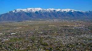
Davis County, Utah
| Davis County, Utah | |
|---|---|
 Davis County, Utah | |
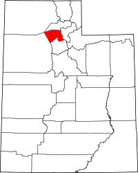 Location in the U.S. state of Utah | |
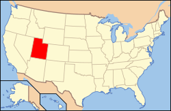 Utah's location in the U.S. | |
| Founded | 1850 |
| Named for | Daniel C. Davis |
| Seat | Farmington |
| Largest city | Layton |
| Area | |
| • Total | 634 sq mi (1,642 km2) |
| • Land | 299 sq mi (774 km2) |
| • Water | 335 sq mi (868 km2), 53% |
| Population (est.) | |
| • (2015) | 336,043 |
| • Density | 1,026/sq mi (396/km²) |
| Congressional districts | 1st, 2nd |
| Time zone | Mountain: UTC-7/-6 |
| Website |
www |
Davis County is a county located in the U.S. state of Utah. As of the 2010 census, the population was 306,479,[1] making it the third-most populous county in Utah. Its county seat is Farmington,[2] and its largest city is Layton. The county was created in 1850[3] and was named for Daniel C. Davis,[4] captain in the Mormon Battalion.
Davis County is part of the Ogden-Clearfield, UT Metropolitan Statistical Area as well as the Salt Lake City-Provo-Orem, UT Combined Statistical Area.
History
Davis County was created on October 5, 1850, with Farmington designated as its county seat, because of its geographic location midway between boundaries at the Weber River on the north and the Jordan River on the south. During its first 50 years, Davis County grew slowly. With the advent of the Utah Central Rail Road in 1870, a transition to mechanized agriculture and a surge of commerce, banking, improved roads, new water systems, and electrification of homes began. However, by 1940, the population was barely 16,000.
With the establishment of Hill Air Force Base in northern Davis County, there was a surge of civilian employment after World War II. The county doubled in population between 1940 and 1950, and doubled again between 1950 and 1960 as part of the nationwide suburb boom that was occurring at the time. By 1990 there were 188,000 residents, and in 2000, there were 239,000. By 2030, the county is expected to have a population of about 360,000.
Today, most of the population resides in Layton, Bountiful, Kaysville, and Clearfield while most of the growth is concentrated in the northwest, northeast, and southwest portions of the county, and especially in such cities as Syracuse, Clinton, West Point, South Weber, and Woods Cross.
Geography
According to the U.S. Census Bureau, the county has a total area of 634 square miles (1,640 km2), of which 299 square miles (770 km2) is land and 335 square miles (870 km2) (53%) is water.[5] It is the smallest county in Utah by land area and second smallest by total area.
The county lies generally between the Great Salt Lake on the west and the Wasatch Range on the east, which rises to a height of 9,707 feet (2,959 m) in the county at Thurston Peak. The Great Salt Lake in the west, which is surrounded by marshland and mudflats, lies at an average elevation of approximately 4,200 feet (1,300 m), varying depending on the water level, which can lead to drastic changes in the lake size due to its shallowness. Davis County includes Antelope Island, which is the largest island in the lake. The entire island is a state park, designated to protect natural scenery and especially wildlife on the island, which includes bighorn sheep, pronghorn, and a bison herd. The populated portion that lies between the Great Salt Lake and the Wasatch Range belongs to the Wasatch Front, a narrow stretch of land that restricts north-south transportation in the county.
Adjacent counties
- Salt Lake County (south)
- Morgan County (east)
- Weber County (north)
- Box Elder County (northwest)
- Tooele County (west)
Climate
Davis County lies in a semiarid climate zone. Snow is frequent during winter, with up to 90 in (230 cm) annually on high bench areas in the east and at least 60 inches (150 cm) on the valley floor. Annual precipitation averages between 18 and 25 inches (460 and 640 mm) in the county, with spring being the wettest season and summer the driest. Summers are hot, with several days each year averaging above 95 °F (35 °C). However, the humidity is low, making for comparatively comfortable temperatures. In winter, temperatures sometimes drop below 0 °F (−18 °C), but rarely for extended periods of time. Compared to Salt Lake County to the south, the weather in Davis County is extreme. Lake-effect snows hit the southern portion of the county harder, and even in non-lake-effect storms, the lack of a rain shadow in Davis County (much of Salt Lake County lies in the rain shadow of the Oquirrh Mountains) means that storms often hit Davis County harder. In addition, canyon winds from the east can sometimes cause devastating wind damage, and wind gusts above 100 mph (160 km/h) have been reported. This occurs when a powerful high pressure system situates itself over Wyoming, and is a common occurrence. Extreme wind events, however, have seemed to decline in frequency in recent years.[6]
National protected area
- Wasatch National Forest (part)
Demographics
| Historical population | |||
|---|---|---|---|
| Census | Pop. | %± | |
| 1850 | 1,134 | — | |
| 1860 | 2,904 | 156.1% | |
| 1870 | 4,459 | 53.5% | |
| 1880 | 5,279 | 18.4% | |
| 1890 | 6,751 | 27.9% | |
| 1900 | 7,996 | 18.4% | |
| 1910 | 10,191 | 27.5% | |
| 1920 | 11,450 | 12.4% | |
| 1930 | 14,021 | 22.5% | |
| 1940 | 15,784 | 12.6% | |
| 1950 | 30,867 | 95.6% | |
| 1960 | 64,760 | 109.8% | |
| 1970 | 99,028 | 52.9% | |
| 1980 | 146,540 | 48.0% | |
| 1990 | 187,941 | 28.3% | |
| 2000 | 238,994 | 27.2% | |
| 2010 | 306,479 | 28.2% | |
| Est. 2015 | 336,043 | [7] | 9.6% |
| U.S. Decennial Census[8] 1790–1960[9] 1900–1990[10] 1990–2000[11] 2010–2014[1] | |||
As of the census[12] of 2010, there were 306,479 people, 93,545 households, and 76,205 families residing in the county. The population density was 1,008.15 people per square mile (388.44/km²). There were 97,570 housing units at an average density of 320.95 per square mile (123.66/km²). The racial makeup of the county was 90.04% White, 1.21% Black or African American, 0.46% Native American, 1.77% Asian, 0.59% Pacific Islander, 3.24% from other races, and 2.69% from two or more races. 8.42% of the population were Hispanic or Latino of any race.
There were 93,545 households out of which 45.1% had children under the age of 18 living with them, 67.99% were married couples living together, 9.59% had a female householder with no husband present, and 18.54% were non-families. 15.23% of all households were made up of individuals and 5.27% had someone living alone who was 65 years of age or older. The average household size was 3.24 and the average family size was 3.63.
In the county, the population was spread out with 37.23% under the age of 20, 6.56% from 20 to 24, 28.13% from 25 to 44, 19.92% from 45 to 64, and 8.15% who were 65 years of age or older. The median age was 29.2 years. For every 100 females there were 100.85 males. For every 100 females age 18 and over, there were 97.09 males.
Religion
- 72% Mormon
- 21.8% Non Religious
- 3% Catholic
- 1% Southern Baptist
- 2.2% Other
Source:[13]
Law and government
A three-member board of commissioners is the county's governing body. Each of these commissioners serve four-year terms, which overlap for the sake of continuity. They are responsible for all county services and operations. They approve, adopt, and amend the budget; they also serve as the legislative body and regulate business licensing in the county's unincorporated areas. The current county commissioners are:
Other elected offices include the County Attorney, Assessor, Clerk/Auditor, Sheriff, Recorder, Surveyor, and Treasurer.
- The assessor is responsible for the valuing of all real property in the county. The current assessor is James B. Ivie.
- The clerk/auditor serves as the county's chief financial and budget officer. The current Clerk/Auditor is Steve Rawlings.
- The treasurer is responsible for collection and investing of county funds. The current Treasurer is Mark Altom.[14]
Economy
Davis County is often characterized as a bedroom community. According to the U.S. Census Bureau's 2004 American Community Survey, 42.3% of the population work in another county.[15] South Davis County commuters who work in Salt Lake County frequently encounter commuting time traffic bottlenecks between Davis and Salt Lake Counties. The Legacy Parkway and FrontRunner commuter rail project were built to alleviate this problem.
The commuter rail stations in the county have spurred plans for extensive transit-oriented development (TOD), including the Station Park development in Farmington. Farmington is also the home of the Lagoon Amusement Park, the primary amusement park located along the Wasatch Front.
Davis County's largest employer is Hill Air Force Base. Hill AFB is a dominant feature of the economy of Davis County. Earnings of civilians at Hill AFB are almost double the state average. Hill AFB accounts for about 12% of the economy of Davis County and about 2.6% of the economy of Utah.[16] Hill AFB provides employment for nearly 23,000 military and civilian personnel (approximately 4,500 active duty, 1,200 reservists, 13,000 federal civil servants, and 4,000 civilian contractors).[17] Other large employers include Davis School District, Lagoon Amusement Park, and Lifetime Products.[18]

Education
Public education in Davis County is served by the Davis School District. There are currently 59 elementary schools, 16 junior high schools, 8 high schools, and 3 alternative schools in the school district. The high schools are as follows:
- Bountiful - Bountiful
- Clearfield - Clearfield
- Davis - Kaysville
- Layton - Layton
- Northridge - Layton
- Syracuse - Syracuse
- Viewmont - Bountiful
- Woods Cross - Woods Cross
The Utah College of Applied Technology operates a campus in Kaysville known as the Davis Applied Technology College (DATC).[19]
Utah State University owns and operates the Utah Botanical Center in Kaysville, which includes an education center. Weber State University also operates a campus in Layton.
Transportation
The most important road in the county is Interstate 15, which runs north-south through the center of the county. US-89 enters parallel to I-15 from Salt Lake County to the south and runs north through North Salt Lake and Bountiful as a city road before merging with I-15. It re-emerges again in Farmington near the Lagoon Amusement Park, heading along the eastern benches on the slopes of the Wasatch Range, entering Weber County near South Weber. US-89 is planned to eventually be upgraded to a freeway through eastern Layton north to its interchange with I-84 near the Weber County border. Congestion is a significant problem in the county, as east-west transportation is restricted by the narrow urban corridor and many of its citizens commute south to Salt Lake County.
To relieve congestion in the county, the Legacy Parkway began construction in 2006. Construction began near the US-89/I-15 interchange in Farmington in 2004, but was soon halted due to a lawsuit filed by environmentalists, who were concerned that the road would harm marshlands along the eastern edge of the Great Salt Lake and asked for a review of the completeness of the environmental impact statement. A settlement was reached in 2005 and the final injunction was lifted in 2006. The Legacy Parkway opened in 2008, running from the US-89/I-15 interchange in Farmington southward to connect with I-215 near the border with Salt Lake County. An extensive trail system, wetland protection measures, and landscaping were implemented along the highway in response to the environmentalist's concerns, in addition to a lower speed limit and a ban of semi-trailer trucks on the highway.[20]
In 2008, the Utah Transit Authority opened the FrontRunner commuter rail line from Salt Lake City north to Ogden, serving the length of Davis County with stations in Woods Cross, Farmington, Layton, and Clearfield.
Major highways
 Interstate 15
 Interstate 84
 Interstate 215
 U.S. Route 89
 State Route 193 - Bernard Fisher Highway
 State Route 67 - Legacy Parkway
Communities

See also
References
- 1 2 "State & County QuickFacts". United States Census Bureau. Retrieved December 29, 2013.
- ↑ "Find a County". National Association of Counties. Archived from the original on 2011-05-31. Retrieved 2011-06-07.
- ↑ "Utah: Individual County Chronologies". Utah Atlas of Historical County Boundaries. The Newberry Library. 2008. Retrieved June 26, 2015.
- ↑ Gannett, Henry (1905). The Origin of Certain Place Names in the United States. Govt. Print. Off. p. 101.
- ↑ "2010 Census Gazetteer Files". United States Census Bureau. August 22, 2012. Retrieved March 27, 2015.
- ↑ Deseret News - 'Active' weather — Neighboring counties Davis and S.L. differ widely in weather. February 9, 2006.
- ↑ "County Totals Dataset: Population, Population Change and Estimated Components of Population Change: April 1, 2010 to July 1, 2015". Retrieved July 2, 2016.
- ↑ "U.S. Decennial Census". United States Census Bureau. Archived from the original on May 11, 2015. Retrieved March 27, 2015.
- ↑ "Historical Census Browser". University of Virginia Library. Retrieved March 27, 2015.
- ↑ Forstall, Richard L., ed. (March 27, 1995). "Population of Counties by Decennial Census: 1900 to 1990". United States Census Bureau. Retrieved March 27, 2015.
- ↑ "Census 2000 PHC-T-4. Ranking Tables for Counties: 1990 and 2000" (PDF). United States Census Bureau. April 2, 2001. Retrieved March 27, 2015.
- ↑ "American FactFinder". United States Census Bureau. Archived from the original on 2013-09-11. Retrieved 2011-05-14.
- ↑ Religions in Davis County, Utah
- ↑ "About Us". www.co.davis.ut.us. Retrieved 2016-05-01.
- ↑ "American FactFinder". Factfinder.census.gov. Archived from the original on 2008-03-31. Retrieved 2010-07-22.
- ↑
- ↑ Archived January 12, 2008, at the Wayback Machine.
- ↑ http://jobs.utah.gov/opencms/wi/regions/northern/davis/davisme.pdf
- ↑ Utah Technical College | Davis Applied Technology College in Utah. Datc.edu. Retrieved on 2013-07-21.
- ↑ Arave, Lynn (September 7, 2008). "Legacy Parkway opens to public on Saturday". Deseret News. Retrieved 2009-07-01.
Further reading
- Leonard, Glen M. (1999). A History of Davis County. Salt Lake City, UT: Utah State Historical Society. ISBN 978-0-913738-43-6. OCLC 41987756.
External links
- Official website
- Davis County Visitor and Relocation Guide, Davis Chamber of Commerce
- Aerial photo of Davis County from USGS via Microsoft Research Maps
 |
Box Elder County | Weber County | | |
| Tooele County | |
Morgan County | ||
| ||||
| | ||||
| Salt Lake County |
Municipalities and communities of Davis County, Utah, United States | ||
|---|---|---|
| Cities | | |
Coordinates: 41°01′N 112°07′W / 41.01°N 112.12°W