South Weber, Utah
| South Weber, Utah | |
|---|---|
| City | |
|
South Weber City Office | |
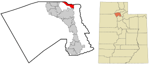 Location in Davis County and the state of Utah | |
| Coordinates: 41°7′54″N 111°55′50″W / 41.13167°N 111.93056°WCoordinates: 41°7′54″N 111°55′50″W / 41.13167°N 111.93056°W | |
| Country | United States |
| State | Utah |
| County | Davis |
| Settled | 1851 |
| Incorporated | 1938 |
| Named for | Weber River |
| Government | |
| • Mayor | Tamara Long |
| Area | |
| • Total | 4.7 sq mi (12.2 km2) |
| • Land | 4.7 sq mi (12.1 km2) |
| • Water | 0.04 sq mi (0.1 km2) |
| Elevation | 4,511 ft (1,375 m) |
| Population (2010) | |
| • Total | 6,051 |
| • Estimate (2014) | 6,731 |
| • Density | 1,443/sq mi (557.1/km2) |
| Time zone | Mountain (MST) (UTC-7) |
| • Summer (DST) | MDT (UTC-6) |
| ZIP codes | 84403, 84405 |
| Area code(s) | 385, 801 |
| FIPS code | 49-71180[1] |
| GNIS feature ID | 1445935[2] |
| Website |
www |

South Weber /ˈwiːbər/ is a city in Davis County, Utah, United States. It is part of the Ogden–Clearfield, Utah Metropolitan Statistical Area. The population was 6,051 at the 2010 census,[3] with an estimated population of 6,731 in 2014.[4]
History
South Weber was the site of the Morrisite War. On June 13, 1862, an estimated 500-man army perched cannons atop the bluffs on the south side of the city, aimed at Joseph Morris. The war lasted three days, and ultimately resulted in the death of Joseph Morris, John Banks, and a few others. Upon seeing their leaders dead, the remainder of the Morrisites surrendered.
South Weber is also known for a week of Bigfoot sightings in February 1980. For one week, residents reported signs of the legendary Sasquatch. At the time, multiple residents claimed to have seen the creature while feeding horses, smelled foul "bigfoot" odors, and found large patches of strange fur throughout the small community. Although no animal was ever found, the legend lives on.
Business Week magazine named South Weber the sixth best suburb in the country in 2009.
Geography
South Weber is located in northeastern Davis County, bordered to the north by the Weber County line. Neighboring cities are Uintah to the north Washington Terrace and Riverdale to the northwest, and Layton to the south. Hill Air Force Base borders the southwest side of the city.
According to the United States Census Bureau, the city has a total area of 4.7 square miles (12.2 km2), of which 0.04 square miles (0.1 km2), or 1.20%, is water.[3] The Weber River forms most of the northern boundary of the city.
Demographics
| Historical population | |||
|---|---|---|---|
| Census | Pop. | %± | |
| 1880 | 239 | — | |
| 1890 | 267 | 11.7% | |
| 1900 | 256 | −4.1% | |
| 1910 | 241 | −5.9% | |
| 1920 | 266 | 10.4% | |
| 1930 | 279 | 4.9% | |
| 1940 | 259 | −7.2% | |
| 1950 | 244 | −5.8% | |
| 1960 | 382 | 56.6% | |
| 1970 | 1,073 | 180.9% | |
| 1980 | 1,575 | 46.8% | |
| 1990 | 2,863 | 81.8% | |
| 2000 | 4,260 | 48.8% | |
| 2010 | 6,051 | 42.0% | |
| Est. 2015 | 6,971 | [5] | 15.2% |
As of the census[1] of 2000, there were 4,260 people, 1,080 households, and 989 families residing in the city. The population density was 920.9 people per square mile (355.2/km²). There were 1,110 housing units at an average density of 239.9 per square mile (92.6/km²). The racial makeup of the city was 95.16% White, 0.49% African American, 0.80% Native American, 0.61% Asian, 0.02% Pacific Islander, 1.20% from other races, and 1.71% from two or more races. Hispanic or Latino of any race were 3.97% of the population.
There were 1,080 households out of which 59.1% had children under the age of 18 living with them, 83.6% were married couples living together, 6.0% had a female householder with no husband present, and 8.4% were non-families. 7.4% of all households were made up of individuals and 2.4% had someone living alone who was 65 years of age or older. The average household size was 3.76 and the average family size was 3.96.
In the city the population was spread out with 39.7% under the age of 18, 11.6% from 18 to 24, 27.6% from 25 to 44, 17.2% from 45 to 64, and 3.9% who were 65 years of age or older. The median age was 24 years. For every 100 females there were 101.6 males. For every 100 females age 18 and over, there were 100.5 males.
The median income for a household in the city was $70,656, and the median income for a family was $72,063. Males had a median income of $48,214 versus $31,250 for females. The per capita income for the city was $19,112. None of the families and 5.7% of the population were living below the poverty line, including no under eighteens and none of those over 64.
References
- 1 2 "American FactFinder". United States Census Bureau. Retrieved 2008-01-31.
- ↑ "US Board on Geographic Names". United States Geological Survey. 2007-10-25. Retrieved 2008-01-31.
- 1 2 "Geographic Identifiers: 2010 Demographic Profile Data (G001): South Weber city, Utah". American Factfinder. U.S. Census Bureau. Retrieved January 11, 2016.
- ↑ "Annual Estimates of the Resident Population for Incorporated Places: April 1, 2010 to July 1, 2014". Retrieved June 4, 2015.
- ↑ "Annual Estimates of the Resident Population for Incorporated Places: April 1, 2010 to July 1, 2015". Retrieved July 2, 2016.
- ↑ "Census of Population and Housing". Census.gov. Retrieved June 4, 2015.
External links
 |
Riverdale, Washington Terrace | Uintah | Huntsville | |
| |
|
|||
| ||||
| | ||||
| Layton | Morgan |
Municipalities and communities of Davis County, Utah, United States | ||
|---|---|---|
| Cities |  | |