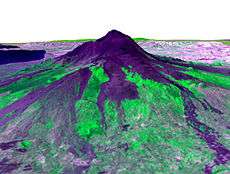
ASTER image draped over terrain model of
Mount EtnaASTER (Advanced Spaceborne Thermal Emission and Reflection Radiometer) is a Japanese sensor which is one of five remote sensory devices on board the Terra satellite launched into Earth orbit by NASA in 1999. The instrument has been collecting superficial data since February 2000.
ASTER provides high-resolution images of the planet Earth in 14 different bands of the electromagnetic spectrum, ranging from visible to thermal infrared light. The resolution of images ranges between 15 and 90 meters. ASTER data are used to create detailed maps of surface temperature of land, emissivity, reflectance, and elevation.
The ASTER GDEM is available at no charge to users worldwide via electronic download.[1]
ASTER Bands
| Band |
Label |
Wavelength
(µm) |
Resolution
(m) |
Nadir or
Backward |
Description |
| B1 |
VNIR_Band1 |
0.520–0.600 |
15 |
Nadir |
Visible green/yellow |
| B2 |
VNIR_Band2 |
0.630–0.690 |
15 |
Nadir |
Visible red |
| B3N |
VNIR_Band3N |
0.760–0.860 |
15 |
Nadir |
Near infrared |
| B3B |
VNIR_Band3B |
0.760–0.860 |
15 |
Backward |
|
| B4 |
SWIR_Band4 |
1.600–1.700 |
30 |
Nadir |
Short-wave infrared |
| B5 |
SWIR_Band5 |
2.145–2.185 |
30 |
Nadir |
| B6 |
SWIR_Band6 |
2.185–2.225 |
30 |
Nadir |
| B7 |
SWIR_Band7 |
2.235–2.285 |
30 |
Nadir |
| B8 |
SWIR_Band8 |
2.295–2.365 |
30 |
Nadir |
| B9 |
SWIR_Band9 |
2.360–2.430 |
30 |
Nadir |
|
| B10 |
TIR_Band10 |
8.125–8.475 |
90 |
Nadir |
Long-wave infrared
or thermal IR |
| B11 |
TIR_Band11 |
8.475–8.825 |
90 |
Nadir |
| B12 |
TIR_Band12 |
8.925–9.275 |
90 |
Nadir |
| B13 |
TIR_Band13 |
10.250–10.950 |
90 |
Nadir |
| B14 |
TIR_Band14 |
10.950–11.650 |
90 |
Nadir |
|
ASTER Global Digital Elevation Model
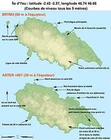
SRTM3 vs. ASTER comparison (
Île d'Yeu), inaccuracies and errors of the latter are indicated by arrows
Version 1
On 29 June 2009, the Global Digital Elevation Model (GDEM) was released to the public.[2][3]
A joint operation between NASA and Japan's Ministry of Economy, Trade and Industry (METI), the Global Digital Elevation Model is the most complete mapping of the earth ever made, covering 99% of its surface.[4][5]
The previous most comprehensive map, NASA's Shuttle Radar Topography Mission, covered approximately 80% of the Earth's surface,[6] with a global resolution of 90 meters,[7] and a resolution of 30 meters over the USA.
The GDEM covers the planet from 83 degrees North to 83 degrees South (surpassing SRTM's coverage of 56 °S to 60 °N), becoming the first earth mapping system that provides comprehensive coverage of the polar regions.[6] It was created by compiling 1.3 million VNIR images taken by ASTER using single-pass[8] stereoscopic correlation techniques,[2] with terrain elevation measurements taken globally at 30 meter (98 ft) intervals.[4]
Despite the high nominal resolution, however, some reviewers have commented that the true resolution is considerably lower, and not as good as that of SRTM data, and serious artifacts are present.[9][10]
Some of these limitations have been confirmed by METI and NASA, who point out that the current version of the GDEM product is "research grade".[11]
Version 2
During October 2011 version 2 of Global Digital Elevation Model was publicly released.[12] This is considered an improvement upon version 1. These improvements include increased horizontal and vertical accuracy,[13] better horizontal resolution, reduced presence of artifacts, and more realistic values over water bodies.[1] However, one reviewer still regards the Aster version 2 dataset, although showing 'a considerable improvement in the effective level of detail', to still be regarded as 'experimental or research grade' due to presence of artefacts.[14]
A recent study[13] has shown that over rugged mountainous terrain the ASTER version 2 data set can be a more accurate representation of the ground than the SRTM elevation model.
See also
References
- 1 2 "METI and NASA Release Version 2 ASTER Global DEM". U.S. Geological Survey / NASA LP DAAC. Retrieved 21 December 2013.
- 1 2 "ASTER Global Digital Elevation Map". NASA. 2009-06-29. Archived from the original on 3 July 2009. Retrieved 2009-06-30.
- ↑ "ASTER Imagery". NASA. 2009-06-29. Retrieved 2009-06-30.
- 1 2 "Most complete earth map published". BBC News. 2009-06-30. Retrieved 2009-07-01.
- ↑ "Nasa satellite map reveals 99% of Earth's land surface for first time". Daily Mail. 2009-07-01. Retrieved 2009-07-01.
- 1 2 "NASA, Japan publish detailed map of Earth". Canada.com. 2009-06-30. Retrieved 2009-07-01.
- ↑ "What is ASTER?". Retrieved 2009-07-01.
- ↑ Nikolakopoulos, K. G.; Kamaratakis, E. K; Chrysoulakis, N. (10 November 2006). "SRTM vs ASTER elevation products. Comparison for two regions in Crete, Greece" (PDF). International Journal of Remote Sensing. 27 (21): 4819–4838. Bibcode:2006IJRS...27.4819N. doi:10.1080/01431160600835853. ISSN 0143-1161. Archived from the original (PDF) on July 21, 2011. Retrieved July 1, 2009.
- ↑ "Virtual Earth Products Reviews". Archived from the original on 31 May 2009. Retrieved 2009-07-01.
- ↑ Hirt, C.; Filmer, M.S.; Featherstone, W.E. (2010). "Comparison and validation of recent freely-available ASTER-GDEM ver1, SRTM ver4.1 and GEODATA DEM-9S ver3 digital elevation models over Australia.". Australian Journal of Earth Sciences. 57 (3): 337–347. Bibcode:2010AuJES..57..337H. doi:10.1080/08120091003677553. Retrieved May 5, 2012.
- ↑ "METI and NASA Release ASTER Global DEM". Archived from the original on 29 May 2009. Retrieved 2009-07-01.
- ↑ "Release of ASTER GDEM Version 2".
- 1 2 Rexer, M.; Hirt, C. (2014). "Comparison of free high-resolution digital elevation data sets (ASTER GDEM2, SRTM v2.1/v4.1) and validation against accurate heights from the Australian National Gravity Database." (PDF). Australian Journal of Earth Sciences. 61 (2). Bibcode:2014AuJES..61..213R. doi:10.1080/08120099.2014.884983. Retrieved April 24, 2014.
- ↑ de Ferranti, Jonathan. "ASTER Digital Elevation Data". Viewfinder Panoramas, UK. Retrieved 21 December 2013.
External links
.jpg)