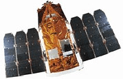
EROS B
 EROS-B Satellite | |
| Mission type | Remote sensing |
|---|---|
| Operator | ImageSat International |
| COSPAR ID | 2006-014A |
| SATCAT № | 29079 |
| Website | ImageSat International |
| Mission duration | 10 years |
| Spacecraft properties | |
| Bus | OPSAT-2000[1] |
| Manufacturer | IAI |
| Launch mass | 350 kilograms (770 lb)[2] |
| Power | 800 watts |
| Start of mission | |
| Launch date | 25 April 2006, 16:47:16 UTC[3] |
| Rocket | Start-1 |
| Launch site | Svobodny 5 |
| Contractor | United Start |
| Orbital parameters | |
| Reference system | Geocentric |
| Regime | Sun-synchronous |
| Perigee | 506 kilometres (314 mi) |
| Apogee | 524 kilometres (326 mi) |
| Inclination | 97.45 degrees |
| Period | 94.79 minutes |
| Epoch | 21 November 2013, 04:17:59 UTC[4] |
The Earth Remote Observation System-B (EROS-B) is the second satellite launched in a series of the EROS family of Israeli commercial Earth observation satellites, designed and manufactured by Israel Aircraft Industries.[5]
The EROS B was launched on April 25, 2006 from Svobodny Launch Complex in eastern Siberia.[6]
Spacecraft
The craft is 2.3m in height and 1.2m in diameter. It weighted 290 kg at launch. The design of the satellite is based on the military reconnaissance satellite Ofeq 3, which was previously built, also by IAI for Israeli government use.
Control Systems
The satellite is equipped with a 3-axis stabilized and a four reaction wheels actuator. The satellite is also equipped with horizon sensors, sun sensors, gyroscopes and magnetometer for altitude determination.[7]
Ground Communication Systems
The satellite is equipped with an imagery link four times faster than the EMOS A at 280Mbit/s, a 15 kbit/s maintenance downlink, and a 15kbit/s command uplink.[8]
Operation
The satellite offers an optical resolution of 70 cm (about two feet), and as of launch date plans were to use it to monitor Iran's developing nuclear program for potential threats to Israeli security.
The satellite is equipped with a CCD pushbroom detector array provides 10,000 pixels per line and a total of 96 lines for selectable TDI observation support. The spacecraft can be operated in both asynchronous and synchronous imaging mode. It has a Ground Sampling Distance of 0.70 m panchromatic.
Unlike the EROS A whose primary purpose is agricultural engineers, the EROS B is more specifically designed for illegal construction supervision, general infrastructure monitoring, and emergency monitoring such as oil and gas exploration.
EROS B is the first commercial satellite to offer high spatial resolution images of night-time lights from space.[9][10]
See also
- EROS (satellite)
- EROS A
- Israel Space Agency
- Science and technology in Israel
- Oriondata Internacional: reseller of EROS-A, EROS-B images in Latin America and derived products like digital elevation model as DEM, DSM or DTM
References
- ↑ Krebs, Gunter. "EROS B". Gunter's Space Page. Retrieved 21 November 2013.
- ↑ "UCS Satellite Database". Union of Concerned Scientists. Retrieved 21 November 2013.
- ↑ McDowell, Jonathan. "Launch Log". Jonathan's Space Page. Retrieved 21 November 2013.
- ↑ Peat, Chris (21 November 2013). "EROS B - Orbit". Heavens Above. Retrieved 21 November 2013.
- ↑ "Serbia Settlement IAI Bond Purchase Boost Fortunes of Israel's ImageSat". SpaceNews. Retrieved 20 November 2013.
- ↑ "EROS-B (Earth Remote Observation System-B)". EOPortal. Retrieved 20 November 2013.
- ↑ "EROS B". Apollo Mapping. Retrieved 20 November 2013.
- ↑ Hellermann, Rani. "EROS B –Operational Experience, Second year of operation2008" (PDF). Retrieved 20 November 2013.
- ↑ Levin, N., Johansen, K., Hacker, J.M., Phinn, S. (2014) A new source for high spatial resolution night time images - the EROS-B commercial satellite. Remote Sensing of Environment, 149, 1-12. doi: 10.1016/j.rse.2014.03.019
- ↑ Katz, Y., Levin, N. (2016) Quantifying urban light pollution - a comparison between field measurements and EROS-B imagery. Remote Sensing of Environment, 177, 65-77. http://dx.doi.org/10.1016/j.rse.2016.02.017