Aggeneys
| Aggeneys | |
|---|---|
 Aggeneys  Aggeneys  Aggeneys
| |
| Coordinates: 29°12′S 18°51′E / 29.200°S 18.850°ECoordinates: 29°12′S 18°51′E / 29.200°S 18.850°E | |
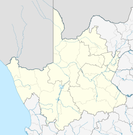
| Country | South Africa |
| Province | Northern Cape |
| District | Namakwa |
| Municipality | Khâi-Ma |
| Established | 1976 |
| Area[1] | |
| • Total | 205.68 km2 (79.41 sq mi) |
| Population (2011)[1] | |
| • Total | 2,262 |
| • Density | 11/km2 (28/sq mi) |
| Racial makeup (2011)[1] | |
| • Black African | 23.1% |
| • Coloured | 61.8% |
| • Indian/Asian | 0.6% |
| • White | 14.3% |
| • Other | 0.3% |
| First languages (2011)[1] | |
| • Afrikaans | 81.5% |
| • Xhosa | 10.3% |
| • Tswana | 3.3% |
| • English | 2.9% |
| • Other | 2.0% |
| PO box | 8893 |
| Area code | 054 |
Aggeneys is a mining town established in 1976 on a farm of that name, situated between Pofadder and Springbok in the Northern Cape, South Africa.
Origin of the name
It has been stated that "no-one is quite certain of the origin of the name Aggeneys".[2] Derived from the Nama language, suggested meanings include "Place of Blood", "Place of Red Clay" or "Place of Reeds". One author favours the last of these: the Nama word ‡a means "reed" while !keis means "place".[3]
Mining and geological contexts
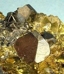
Aggeneys the town, on a farm of that name, was founded to service the Black Mountain Mine, an underground base-metal operation nearby, currently employing over 600 permanent staff. This zinc/lead/copper/silver mine is just to the west of the town.[4] The produce of the mine is transported by truck to the nearest railway line, located 150 km (90 mi) to the south-east along a virtually straight gravel (dirt) road. A major zinc deposit has been identified in the nearby Gamsberg inselberg, also set to be mined.
The ranges of hills, mountains and inselbergs in the area display some of the most diverse and complex geology in Southern Africa including some of the richest known concentrations of copper, lead and zinc.[4]
Environmental setting
In a semi-desert landscape, lawns and trees planted when the town was established accentuate the sense of ‘oasis’ and one of the town’s principal attractions is its golf course. The town’s water wants are greater than could be supplied by any nearby springs, however, and all is kept green by water pumped up from the Orange River some 40 km to the north.
But beyond the edges of town the arid conditions and the unique ecologies on the various inselbergs, peaks, hills and plains, with their varied rocky and shallow soil substrate, support a wide range of plants, animals, birds and insects, including rare and endemic species. The writer William Charles Scully wrote that, “for sheer uncompromising aridity, for stark grotesque naked horror, these mountains stand probably unsurpassed on the face of the globe.”[5]
Average, but variable, annual rainfall at the town is about 112 mm, with greatest precipitation occurring between January and April. The lowest recorded annual rainfall (11 mm) was measured in 1992, while the ‘wettest’ year (220 mm) was recorded in 2006. Temperatures average between 15 °C and 38 °C in summer and between 0 °C and 18 °C in winter.[4]
Close by is the mountain of Ghaamsberg which is thought to house some of the last known indigenous Bushman tribes.
Transportation
The town is served by an airstrip known as the Aggeneys Airport. No scheduled flights operate to and from this airstrip. [6]
References
- 1 2 3 4 "Main Place Aggeneys". Census 2011.
- ↑ Nienaber, G.S., & Raper, P.E. 1977. Toponymica Hottentotica. SA Naamkundesentrum RGN Naamkudesreeks 6, p 173.
- ↑ Burger, C.R. 1986. ’N ondersoek na die oorsprong en betekenis van plek- en plaasname in die Landdrosdistrik Namakwaland. Universiteit Stellenbos.
- 1 2 3 Aggeneys: Your oasis in the desert
- ↑ Cited by William Dicey, Borderline, p 167.
- ↑ Airport information for Aggeneys Airport (FAAG). DAFIF. October 2006.
| Wikimedia Commons has media related to Minerals of Aggeneys. |
Municipalities and communities of Namakwa District Municipality, Northern Cape | ||
|---|---|---|
District seat: Springbok | ||
| Hantam | .svg.png) | |
| Kamiesberg | ||
| Karoo Hoogland | ||
| Khâi-Ma | ||
| Nama Khoi | ||
| Richtersveld | ||