Goodhouse
| Goodhouse | |
|---|---|
|
Ford at Goodhouse | |
 Goodhouse  Goodhouse  Goodhouse
| |
| Coordinates: 28°54′S 18°15′E / 28.9°S 18.25°ECoordinates: 28°54′S 18°15′E / 28.9°S 18.25°E | |
| Country | South Africa |
| Province | Northern Cape |
| District | Namakwa |
| Municipality | Nama Khoi |
| Area[1] | |
| • Total | 0.30 km2 (0.12 sq mi) |
| Population (2011)[1] | |
| • Total | 171 |
| • Density | 570/km2 (1,500/sq mi) |
| Racial makeup (2011)[1] | |
| • Black African | 0.6% |
| • Coloured | 98.8% |
| • Other | 0.6% |
| First languages (2011)[1] | |
| • Afrikaans | 96.5% |
| • English | 2.9% |
| • Other | 0.6% |
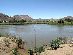
Goodhouse is a town in Nama Khoi Local Municipality in the Northern Cape province of South Africa.
Locality with a landing-strip, on the southern bank of the Orange River, 60 km south-west of Warmbad and 60 km east-south-east of Vioolsdrif. The name is a folk etymological adaptation of the Khoekhoen Gudaos, 'sheep ford', said to be the place where the Namas crossed the Orange River with their sheep when they trekked from Little Namaqualand to Great Namaqualand.[2]
References
- 1 2 3 4 "Main Place Goodhouse". Census 2011.
- ↑ Raper, Peter E. (1987). Dictionary of Southern African Place Names. Internet Archive. p. 182. Retrieved 28 August 2013.
Municipalities and communities of Namakwa District Municipality, Northern Cape | ||
|---|---|---|
District seat: Springbok | ||
| Hantam | .svg.png) | |
| Kamiesberg | ||
| Karoo Hoogland | ||
| Khâi-Ma | ||
| Nama Khoi | ||
| Richtersveld | ||
This article is issued from Wikipedia - version of the 8/18/2016. The text is available under the Creative Commons Attribution/Share Alike but additional terms may apply for the media files.