Agios Vlasios, Magnesia
| Agios Vlasios Άγιος Βλάσιος | |
|---|---|
 | |
 Agios Vlasios | |
| Coordinates: 39°20′N 23°3′E / 39.333°N 23.050°ECoordinates: 39°20′N 23°3′E / 39.333°N 23.050°E | |
| Country | Greece |
| Administrative region | Thessaly |
| Regional unit | Magnesia |
| Municipality | Volos |
| Municipal unit | Artemida |
| Lowest elevation | 251 m (823 ft) |
| Population (2011)[1] | |
| • Rural | 322 |
| Community[1] | |
| • Population | 515 (2011) |
| Time zone | EET (UTC+2) |
| • Summer (DST) | EEST (UTC+3) |
| Postal code | 385 00 |
| Area code(s) | 24280 |
| Vehicle registration | BO |
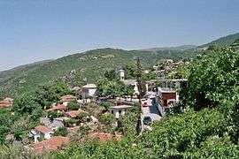
Agios Vlasios (Greek: Άγιος Βλάσιος meaning Saint Blaise, before 1927: Καραμπάσι - Karampasi,[2] Turkish: Karabaş "black head") is a village and a community in the municipal unit of Artemida, Magnesia, Greece. Agios Vlasios is situated on the slopes of mount Pelion, 1.5 km west of Agios Georgios Nileias, 2 km northeast of Ano Lechonia and 11 km east of Volos. Its population in 2011 was 515. The name comes from the church of the village.
Subdivisions
The community Agios Vlasios consists of the following villages:
- Agios Vlasios [2011 pop: 322]
- Malaki [pop: 113]
- Palaiokastro [pop: 55]
- Strofilos [pop: 25]
Population
| Year | Village population | Community population |
|---|---|---|
| 1981 | - | 772 |
| 1991 | 548 | - |
| 2001 | 485 | 785 |
| 2011 | 322 | 515 |
History
During the Turkish Era, the village Palaiokastro which is located between Ano Lechonia and Agios Vlasios was inhabited by Turks. After Thessaly joined Greece in 1881 Agios Vlasios (then Karampasi) became a part of the municipality of Nileia. In 1912, it became an independent community. In 1997, Agios Vlasios became a part of the municipality of Artemida which has its seat at nearby Ano Lechonia. In 2010 Artemida became part of the municipality of Volos.[3]
See also
References
- 1 2 "Απογραφή Πληθυσμού - Κατοικιών 2011. ΜΟΝΙΜΟΣ Πληθυσμός" (in Greek). Hellenic Statistical Authority.
- ↑ Name changes of settlements in Greece
- ↑ EETAA local government changes
External links
| Wikivoyage has a travel guide for Agios Vlasios. |