Ahwatukee, Phoenix
Coordinates: 33°20′30.3″N 111°59′2.5″W / 33.341750°N 111.984028°W
| Ahwatukee "The Nice Side Of The Hill" | |
|---|---|
| Urban village of Phoenix, Arizona | |
| Village of Ahwatukee | |
|
A typical Ahwatukee neighborhood as seen from South Mountain Park | |
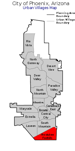 Location of Ahwatukee Foothills highlighted in red. | |
| Country | United States |
| State | Arizona |
| County | Maricopa |
| City | Phoenix |
| Area[1] | |
| • Total | 35 sq mi (90 km2) |
| Population (2010)[2] | |
| • Total | 77,061 |
| • Density | 2,200/sq mi (800/km2) |
| Website | Ahwatukee Planning Committee |

Ahwatukee is a urban village of the City of Phoenix, Arizona bordered on the north by South Mountain Park and Guadalupe Road, on the east by Interstate 10 and the cities of Chandler, Guadalupe, and Tempe, and on the south and west by the Gila River Indian Community. It is the southernmost of the city's 15 urban villages. As of 2010, the 35.8 square-mile (92.7 km²) neighborhood has a population of 77,249.[3]
Although annexed by the city of Phoenix between 1982 and 1987, before substantial residential growth, many of Ahwatukee's residents do not strongly associate their region with the rest of the city, due in part to its geographic isolation (South Mountain and South Mountain Park separate Ahwatukee from the other 14 urban villages of Phoenix, which lie to the north).
History
Legend has it that in 1921, Dr. and Mrs. W.V.B. Ames built a house on approximately 2,000 acres (810 ha) on the southeast side of South Mountain. They gave the area its original Spanish name, Casa de Sueños, which in English means "House of Dreams". Dr. Ames died within just three months of moving into the house, and after Mrs. Ames' death, in 1933, the house and most of the land were willed to St. Luke's Hospital.[4]
In 1935, the house and land were bought by Miss Helen Brinton, who appeared to have retranslated the name of the house to the Crow word which now serves as the name of the village.[5] The house was demolished in 1979, and parts of it were used to build the Our Lady of Guadalupe church.
As it turns out, the Crow translation for "House of Dreams" (ashe ammeewiawe) sounds nothing like Ahwatukee. More likely, Brinton named the town after the Crow words awe chuuke, meaning "land on the other side of the hill" or "land in the next valley". This is, at first glance, a curious choice on her part because the Crow are a native northern plains tribe originally based in Wyoming, now residing in southeast Montana, and have never been associated with Arizona where the Apache, Hopi, Pima, and Navajo peoples are indigenous. Brinton, however, actually having spent much time in the Wyoming (Crow) vicinities and finally making her last home there, would have very likely been strongly influenced by her experience in Wyoming enough to use a Crow-derived name for the beloved land she left behind. This seeming inconsistency only adds to the lore of Ahwatukee.[6]
In 1971, part of the land was purchased, subdivided, and developed into an HOA by the Presley Development Company.
Marty Gibson was the first to write a book on the history of Ahwatukee, titled "The History of Ahwatukee".[7]
Ahwatukee has grown as Phoenix acquired other land parcels to the west, including land owned by International Harvester, which operated a proving ground for earth-moving equipment there from 1947 to 1983. The state of Arizona has bought, sold, or swapped land several times, including transferring state trust land to developers in controversial auctions in which residents and conservationists have lobbied for the space to be converted to parkland.[8][9]
Neighborhood characteristics
Surrounded to the northwest by South Mountain Park, and blocked to the east by I-10 and to the south by the Gila River Indian Community, Ahwatukee Foothills is geographically isolated from the city which it is part of, Phoenix. Due to its relatively few access points (mainly through a few bridges across Interstate 10), it has been called the world's largest cul-de-sac. The village will soon no longer be able to claim this title, as they will be gaining a western exit due to the finalized construction of the Loop 202 freeway which will connect the eastern bordering I-10 E to the I-10 W by via Ahwatukee's southern border. The decision to proceed with the construction has been extremely controversial.
Education
The area's K-8 students are served by the Kyrene School District. The Kyrene Schools in Ahwatukee include Kyrene Cerritos (K-5), Kyrene De La Colina (K-5), Kyrene de la Esperanza (K-5), Kyrene de las Lomas (K-5), Kyrene de la Estrella (K-5), Kyrene Monte Vista (K-5), Kyrene de los Lagos (K-5), Kyrene del Milenio (K-5), and Kyrene de la Sierra (K-5) elementary schools, and Centennial (6-8), Akimel A-al (6-8), Altadeña (6-8) middle schools. High school students go to one of two in the area: Desert Vista and Mountain Pointe. Both schools are operated by the Tempe Union High School District, the best, by test scores, school district in Arizona. There are also a number of private/charter schools, including Desert Garden Montessori (serving ages infant-high school), Inspire Kids Montessori (which opened in June 2010 and serves children ages 2–6), Keystone Montessori School, Horizon Community Learning Center Charter School, Skyline Technical High School, the Summit School of Ahwatukee (a private, independent school serving children ages 2.5–13 years old), St. John Bosco Catholic School (a private, Catholic school which opened in 2001 serving preschool - 8th grade), and public charter school BASIS Ahwatukee (which opened in August 2013 initially serving grades 5-10, and will add a grade each year until serving grades 5-12 in 2015. BASIS Ahwatukee is related to nationally ranked public charter schools BASIS Tucson North and BASIS Scottsdale).
Climate
Ahwatukee receives approximately 6 inches (150 mm) of rainfall yearly.[10] Temperatures are mild during the winter months and daily highs average around 67 °F (19 °C). In the summer, daily high temperatures average around 106 °F (41 °C). very close to that of the actual city of Phoenix Sky Harbor Airport which is almost directly due north of the heart of Ahwatukee on the North side of the South Mountain Park.
Snow is extremely rare for the area, but on occasion can be seen on the Sierra Estrella mountain range to the southwest. There is hail on occasion in the foothills.
Recreation
Ahwatukee with its proximity to the South Mountain Park, a Phoenix city park, has numerous outdoor activity opportunities. Cycling, hiking, baseball, and soccer are common activities.
Hiking
Hiking in the Ahwatukee area is a popular activity in and around South Mountain Park. Telegraph Pass, Pima Canyon and Beverly Canyon are all popular trail heads with dozens of other trail areas also available.
Hiking Links
Cycling
Ahwatukee is a destination for road cyclists and mountain bikers. Road cycling clubs and community members utilize Pecos Road and the hills of Ahwatukee near 5th Avenue and Desert Foothills Parkway for training and scenic rides alike. A park and ride location is often used as a starting point for cyclists who live outside of the village.
Mountain bikers utilize the trails of South Mountain Park for riding opportunities. Various trails are available rated from easy to difficult throughout South Mountain Park.
Volleyball
Within the Club West community, there is an active volleyball group that holds drop in volleyball for Club West residents throughout the year. More information about this program can be found at Club West Volleyball. Volleyball is the most played sport within Ahwatukee. Many individuals are involved in the volleyball weither through coaching or playing themselves.
Golf
Three golf courses are located within the village including:
Miscellaneous
Famous residents include Larry Fitzgerald, Todd McFarlane, Daniel Kelly and Mark Calcavecchia.
References
- ↑ https://www.phoenix.gov/pddsite/Documents/pdd_pz_pdf_00019.pdf
- ↑ https://www.phoenix.gov/pddsite/Documents/pdd_pz_pdf_00220.pdf
- ↑ Cathryn Creno. Census shows little growth in Ahwatukee, The Arizona Republic, May 13, 2011
- ↑ http://www.ahwatukeehoa.com/sub_category_list.asp?category=4&title=ABM+History ABM History
- ↑ http://www.ahwatukeehoa.com/sub_category_list.asp?category=4&title=ABM+History ABM History
- ↑ Reflecting on what we call Ahwatukee Archived December 20, 2010, at WebCite
- ↑ http://www.arcadiapublishing.com/9780738548555/Phoenixs--Ahwatukee-Foothills
- ↑ Archived February 15, 2005, at the Wayback Machine.
- ↑ Archived February 16, 2005, at the Wayback Machine.
- ↑ Ahwatukee, Arizona Weather, Climate | Average Monthly Temperatures Archived December 20, 2010, at WebCite
External links
- Ahwatukee Foothills News: Community News & Events
- Planning a Move: Ahwatukee
- EastValley.com: Ahwatukee Foothills
- Hiking Information for Ahwatukee Area
- ABM History
- City of Phoenix Planning: Ahwatukee Foothills Village
- Ahwatukee Community: Ahwatukee Communities