Ai-Petri
| Ai-Petri | |
|---|---|
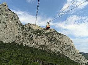 Cablecar ascending Ai-Petri | |
| Highest point | |
| Elevation | 1,234.2 m (4,049 ft) |
| Coordinates | 44°27′4″N 34°3′10″E / 44.45111°N 34.05278°ECoordinates: 44°27′4″N 34°3′10″E / 44.45111°N 34.05278°E |
| Geography | |
.jpg) Ai-Petri | |
| Parent range | Crimean Mountains |
Ai-Petri (Ukrainian: Ай-Петрі, Russian: Ай-Петри, Crimean Tatar: Ay Petri); (translated from Greek. Saint Peter) is a peak in the Crimean Mountains. For administrative purposes it is in the Yalta municipality of Crimea. The name has Greek origin, and is translated as St. Peter (Greek: Άγιος Πέτρος).
Overview
Ai-Petri is one of the windiest places in Crimea. The wind blows for 125 days a year, reaching a speed of 50 m/s (110 mph).[1]
The peak is located above the city of Alupka and the town of Koreiz.
There is a cable car that takes passengers from a station near Alupka to the main area in Ai-Petri.
Climate
| Climate data for Ai-Petri (1961–1990) | |||||||||||||
|---|---|---|---|---|---|---|---|---|---|---|---|---|---|
| Month | Jan | Feb | Mar | Apr | May | Jun | Jul | Aug | Sep | Oct | Nov | Dec | Year |
| Daily mean °C (°F) | −3.6 (25.5) |
−3.1 (26.4) |
−0.5 (31.1) |
4.9 (40.8) |
9.5 (49.1) |
12.9 (55.2) |
15.1 (59.2) |
14.7 (58.5) |
11.0 (51.8) |
6.5 (43.7) |
2.6 (36.7) |
−1.5 (29.3) |
5.7 (42.3) |
| Average precipitation mm (inches) | 154 (6.06) |
123 (4.84) |
81 (3.19) |
61 (2.4) |
68 (2.68) |
71 (2.8) |
55 (2.17) |
56 (2.2) |
64 (2.52) |
62 (2.44) |
107 (4.21) |
173 (6.81) |
1,075 (42.32) |
| Source: NOAA[2] | |||||||||||||
Images
-
.jpg)
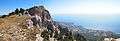
A panoramic view from Ai-Petri.
-

View of Ai-Petri from Vorontsov's Palace in Alupka.
-
View on Ai-Petri
-
_da%C4%9Flar%C4%B1.jpg)
View of Ai-Petri from Vorontsov's Palace in Alupka.
-
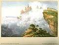
Ai-Petri in the 1850s, by Carlo Bossoli
References
| Wikimedia Commons has media related to Aj-Petri. |
- ↑ Ai-Petri Mountain (in Russian)
- ↑ "Aj–Petri Climate Normals 1961-1990". National Oceanic and Atmospheric Administration. Retrieved September 29, 2016.
| Mountains |  | |
|---|---|---|
| Palaces | ||
| Others | ||