Arabat Spit
| Arabat Arrow | |
| Арабатська стрілка Арабатская стрелка | |
| spit | |
| | |
| Country | Ukraine/Russian Federation (disputed[nb 1]) |
|---|---|
| Regions | Crimea, Kherson Oblast |
| Districts | Henichesk, Nyzhnyohirsk, Sovyetsky, Kirovske, Leninske |
| Landmark | Azov-Syvash (Nature Preserve) |
| Population | 3,664 (2001) |
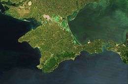
The Arabat Spit (Ukrainian: Арабатська коса, Russian: Араба́тская коса́) or Arabat Arrow is a spit (narrow strip of land) which separates a large, shallow and very salty system of lagoons named Syvash from the Sea of Azov. The spit is located between the Henichesk Strait to the north and the north-eastern shores of Crimea to the south.[3]
Name
The spit is commonly called the Arabat Arrow (Ukrainian: Арабатська стрілка, Arabatska strilka; Crimean Tatar: Arabat beli; Russian: Арабатская стрелка, Arabatskaya strelka) in Russia and Ukraine. "Arrow" is not an idiomatic Russian or Ukrainian name for "spit", rather this peninsula is called an arrow for unknown reasons, perhaps because it is very long and thin and rather straight.[4]
The Arabat part of the name presumably comes from the Arabat Fortress, a 17th century Turkish fort at the southern end of the spit. "Arabat" derives from either Arabic "rabat" meaning a "military post" or Turkic "arabat" meaning a "suburb".[5]
Geography and geology
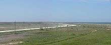
The Arabat Arrow is 112 km (70 mi) long,[6] and from 0.270 to 8 km (0.17 to 5.0 mi) wide;[4][7][8] its surface area is 395 km2 (153 sq mi) and thus the average width is 3.5 km (2.2 mi). The spit is low and straight on the Azov Sea side, whereas its Sivash side is more convoluted. It contains two areas which are 7–8 km (4–5 mi) wide and have brown-clay hills; they are located 7.5 km (4.7 mi) and 32 km (20 mi) from the Henichesk Strait. The top layers of other parts of the spit are formed by sand and shells washed by the flows of the Azov Sea. Its vegetation mostly consists of various weed grasses, thorn, festuce grasses, spear grass, crambe, salsola, salicornia, Carex colchica, tamarisk, rose hip, liquorice, etc.[9][10] Offshore water is shallow with the depth reaching 2 m (7 ft) only some 100–200 m (330–660 ft) from the shore.[11] Its temperature is around 0 °C (32 °F) in winter (near freezing), 10–15 °C (50–59 °F) in spring and autumn, and 25–30 °C (77–86 °F) in summer; air temperature is almost the same.[12]
The spit is very young and was created by sedimentation processes around 1100–1200 AD.[13]
History
The Arabat Arrow was wild until 1835 when a road and five stations at 25–30 km (16–19 mi) intervals were built along it for postal delivery. Later in the 19th century, 25 rural and 3 military settlements and one village named Arabat appeared on the spit. The rural population amounted to some 235 people whose occupation was mostly fishery, farming and salt production. The latter activity is traditional for the region due to the vast areas of shallow and very saline water in the Sivash lagoons. Salt production in the 19th century was about 24,000 tonnes per year (26,000 short tons per year) on the Arabat Arrow alone.[10]
Nowadays, the spit is a health resort and its Azov Sea side is used as a beach.
While the spit is geophysically a part of the Crimean Peninsula, politically its northern half belongs to Kherson Oblast, Ukraine, while its southern portion is a part of the Autonomous Republic of Crimea;[4] since the internationally disputed unilateral March 2014 annexation of Crimea by Russia, Crimea is under the de facto administration of the Russian Republic of Crimea.[1][2] The entirety of the spit was occupied during the annexation, although Russia withdrew its forces from the northern Kherson side in December 2014.[14]
Populated places
The rural communities of Shchaslyvtseve and Strilkove are located in the northern section of the spit, within the Kherson Oblast. The community of Solyane is located in the southern part of the spit, administered as part of the Republic of Crimea.
See also
Notes
- ↑ The status of the Crimea and of the city of Sevastopol is currently under dispute between Russia and Ukraine; Ukraine and the majority of the international community consider the Crimea to be an autonomous republic of Ukraine and Sevastopol to be one of Ukraine's cities with special status, while Russia, on the other hand, considers the Crimea to be a federal subject of Russia and Sevastopol to be one of Russia's three federal cities since the March 2014 annexation of Crimea by Russia.[1][2]
References
- 1 2 Gutterman, Steve. "Putin signs Crimea treaty, will not seize other Ukraine regions". Reuters.com. Retrieved 26 March 2014.
- 1 2 Ukraine crisis timeline, BBC News
- ↑ Semenov, p.624
- 1 2 3 Shutov, Introduction
- ↑ Arabat Foretress (in Russian)
- ↑ Petrov, V.P. (1964). Geography of the Soviet Union: Physical features. p. 112.
- ↑ V. I. Borisov and E. I. Kapitonov (1973). Azov Sea (in Russian). KKI.
- ↑ "Sivash" (in Russian). Great Soviet Encyclopedia.
- ↑ Shutov, Part 1
- 1 2 Semenov, p.111
- ↑ Арабатская стрелка (in Russian)
- ↑ Shutov, Part 5
- ↑ Shutov, Part 4
- ↑ Россия убрала войска с Арабатской стрелки [Russian troops removed from the Arabat Spit] (in Russian). Ukrinform. 9 December 2014. Retrieved 14 April 2016.
Bibliography
- Semenov, Petr Petrovich (1862). Geografichesko-statisticheskìĭ slovar' Rossìĭskoĭ imperìi (Geographical-statistical disctionary of Russian Empire) (in Russian). Oxford University.
- Shutov, Yu. "Арабатская стрелка" (in Russian) Tavria, 1983
External links
| Wikimedia Commons has media related to Arabat Spit. |
| Mountains |  | |
|---|---|---|
| Palaces | ||
| Others | ||
Coordinates: 45°42′N 35°00′E / 45.700°N 35.000°E