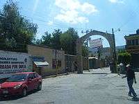
Ajacuba
| Ajacuba | ||
|---|---|---|
| Municipality and city | ||
| ||
 | ||
|
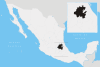
Ajacuba Location in Mexico | ||
| Coordinates: 20°05′N 99°07′W / 20.083°N 99.117°WCoordinates: 20°05′N 99°07′W / 20.083°N 99.117°W | ||
| Country |
| |
| State | Hidalgo | |
| Municipal seat | Ajacuba | |
| Area | ||
| • Total | 192.7 km2 (74.4 sq mi) | |
| Population (2010) | ||
| • Total | 17,055 | |

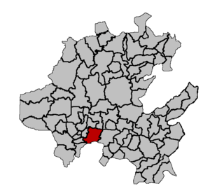
Ajacuba is a town and one of the 84 municipalities of Hidalgo, in central Mexico. The municipality covers an area of 192.7 km².
As of 2005, the municipality had a total population of 16,111.[1]
Geography
It is located between the parallels 99° 27’ 51” and 99° 07’ 32” west longitude, and 20° 05’ 35” and 18° 55’ 22” north latitude. Ajacuba borders. It covers a total surface area of 192.7 km² at an altitude of 6,634 ft. In the year 2010 census by INEGI, it reported a population of 17,055.[2]
The town of Ajacuba, a municipal seat, has governing jurisdiction over the following communities: Tezontlale, Tocomatlan, and Tulancalco.[3] The total municipality extends 96.37 and borders with the municipalities of Tetepango, San Agustín Tlaxiaca, Atitalaquia, Atotonilco de Tula, Progreso de Obregón and the state of México (Hueypoxtla and Apaxco).
The municipal seat is in a small, elongated valley but most of the municipality is inside of the Mezquital Valley.[4] The highest mountain the Picacho in the Sierra Tezontlalpa, it rises 2,800 metres (9,200 ft) above sea level,[5] on the border between the municipalities of San Agustín Tlaxiaca and Atitalaquia.
Climate
| Climate data for Ajacuba | |||||||||||||
|---|---|---|---|---|---|---|---|---|---|---|---|---|---|
| Month | Jan | Feb | Mar | Apr | May | Jun | Jul | Aug | Sep | Oct | Nov | Dec | Year |
| Average high °C (°F) | 24.1 (75.4) |
24.4 (75.9) |
26.2 (79.2) |
27.1 (80.8) |
27.3 (81.1) |
26 (79) |
25 (77) |
25.6 (78.1) |
24.5 (76.1) |
24.4 (75.9) |
23.7 (74.7) |
24.2 (75.6) |
25.2 (77.4) |
| Average low °C (°F) | 7.7 (45.9) |
8.2 (46.8) |
9.5 (49.1) |
10.9 (51.6) |
11 (52) |
11.2 (52.2) |
10.9 (51.6) |
11 (51.8) |
10.4 (50.7) |
10 (50) |
8.6 (47.5) |
8.6 (47.5) |
9.8 (49.6) |
| Average precipitation mm (inches) | 10 (0.4) |
10 (0.4) |
10 (0.4) |
30 (1.2) |
36 (1.4) |
80 (3) |
84 (3.3) |
71 (2.8) |
74 (2.9) |
28 (1.1) |
10 (0.4) |
3 (0.1) |
439 (17.3) |
| Source: Weatherbase [6] | |||||||||||||
Demography
Populated places in Ajacuba
| Town | Population |
| Total | ' |
| Ajacuba | |
| Santiago Tezontlale | |
| Tulancalco | |
| San Nicolás Tecomatlán |
References
- ↑ "Ajacuba". Enciclopedia de los Municipios de México. Instituto Nacional para el Federalismo y el Desarrollo Municipal. Retrieved December 27, 2008.
- ↑ Ajacuba municipality SEDESOL, Catálogo de localidades.
- ↑ INEGI. "Link to tables of population data from Census of 2005 INEGI: Instituto Nacional de Estadística, Geografía e Informática". Archived from the original on 2010-01-18. Retrieved 2008-10-25.
- ↑ []
- ↑
- ↑ "Weatherbase: Historical Weather for Ajacuba, Hidalgo". Weatherbase. 2011. Retrieved on November 24, 2011.