Albina, Suriname
| Albina | |
|---|---|
|
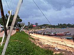
Albina in 2008 | |
 Albina Location in Suriname | |
| Coordinates: 5°30′N 54°03′W / 5.500°N 54.050°W | |
| Country |
|
| District | Marowijne District |
| Resort (municipality) | Albina |
| Area | |
| • Total | 397 km2 (153 sq mi) |
| Elevation | 5 m (16 ft) |
| Population (2012 census) | |
| • Total | 5,247 |
| • Density | 13/km2 (34/sq mi) |
Albina is a town in eastern Suriname, and is capital of the Marowijne District. The town lies on the west bank of the Marowijne river (Maroni river), which forms the border with French Guiana, directly opposite the French Guianan town of Saint-Laurent-du-Maroni, to which it is connected by a frequent ferry service.
Albina can be reached by bus via the East-West Link. The distance between Paramaribo and Albina is about 150 kilometres (95 mi). Because of the war in the second half of the 1980s a great part of the area including the road to Albina was destroyed. Much of Albina was destroyed during the Maroon rebellions in the 1980s–1990s.
The town has a small airport, the Albina Airstrip, with a 650-metre (2,150 ft) asphalt runway in use since 1953.
Albina has a small boat (korjaal) connection to Galibi. The journey across the water takes about 1.5 hrs. There is a beach and a small tourist shop. The main reason tourists visit Galibi is to see the turtles, which come from all over the world (including places as distant as Costa Rica and Australia) to lay their eggs in Suriname. Poachers also come, to collect the eggs to sell them on the market.
Sister cities
Coordinates: 5°30′N 54°03′W / 5.500°N 54.050°W
See also
| Brokopondo District |  | |
|---|---|---|
| Commewijne District | ||
| Coronie District | ||
| Marowijne District | ||
| Nickerie District | ||
| Para District | ||
| Paramaribo District | ||
| Saramacca District | ||
| Sipaliwini District | ||
| Wanica District | ||