Alindao
| Alindao | |
|---|---|
|
Alindao in 1924 | |
 Alindao Location in Central African Republic | |
| Coordinates: 5°2′0″N 21°13′0″E / 5.03333°N 21.21667°ECoordinates: 5°2′0″N 21°13′0″E / 5.03333°N 21.21667°E | |
| Country |
|
| Prefecture | Basse-Kotto |
| Population (2003) | |
| • Total | 14,401 |
Alindao is a town and sub-prefecture located in the Central African Republic prefecture of Basse-Kotto. It lies at the junction of the National Route 2 and 22. Alindao had a population of 14,401 as of the 2003 census; and a calculated 2013 population of 15,213.[1] The town is the seat of the Roman Catholic Diocese of Alindao. It has a small airport, Alindao Airport. A Catholic Mission was established at Alindao during French occupation under French Equatorial Africa.[2]
Economy
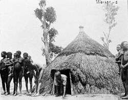
The economy is based on food crops and cash crops (mainly coffee), and the processing of agricultural products. Fishing,[3] hunting, trade and craft activities are also local employment practices but the majority live in poverty. The locals reside in houses with huge thatched roofs and mud walls painted in colored clay.[4]
Towns and villages
- Abouma
- Akpia
- Alepa
- Alindao
- Amoko
- Bada [5°'0"N 21°8'0"E]
- Bada [4°50'0"N 21°20'0"E]
- Bada [4°47'0"N 21°12'0"E]
- Badji
- Balada
- Banan
- Banda [5°20'0"N 21°'0"E]
- Banda [5°'0"N 21°9'0"E]
- Banda [4°52'0"N 21°20'0"E]
- Banda [4°'0"N 21°'0"E]
- Bangba
- Belogba
- Bitou
- Bokoula
- Bondo
- Borota
- Boroudou
- Boulouvou
- Bourou
- Boybangoro
- Boykette
- Congo
- Dabizi
- Dahou
- Ddebo
- Diogo
- Djongo
- Doko
- Drekapou
- Gambito [4°50'0"N 21°17'0"E]
- Gambito [4°47'0"N 21°2'0"E]
- Gbada
- Gbadou
- Gbana
- Gbileba
- Gboundou
- Goffo
- Gongo
- Gopala
- Gouada
- Gouadji
- Gouakiri [5°10'0"N 21°18'0"E]
- Gouakiri [5°9'0"N 21°17'0"E]
- Gouamatou
- Gounda
- Goussa
- Goussou [5°15'0"N 21°'0"E]
- Goussou [4°55'0"N 21°20'0"E]
- Govo
- Gowe
- Goyo
- Guela
- Gueloumanda
- Kabou
- Kadja
- Kalaye
- Kaoua
- Kodo
- Kola
- Kologbo
- Kolomboyo
- Kongbo
- Kongo
- Kouledo
- Koumba
- Kpakpa
- Laodeka
- Liou
- Loe
- Mazogbo
- Mbele
- Mbiloba
- Mede
- Mia
- Moko
- Moro
- Ndjala
- Ngalia
- Ngapo
- Ngara
- Ngbindjou
- Ngoula
- Ngoule
- Ngrihou
- Nougolo
- Oroko
- Ouaga [5°37'0"N 21°'0"E]
- Ouaga [5°36'0"N 21°'0"E]
- Ouama
- Ouate
- Ouenguele
- Ouli
- Pagui
- Pandoko
- Pigala
- Poudjio
- Rokouzou
- Sounda
- Tagbale
- Tagoua
- Tchinda
- Tchingoto
- Teou
- Togbo
- Tomba
- Yota
- Youkou
- Zougao
- Zoulouma
Notable people
- Emmanuel Dongala (1941-) -one of the Congo's greatest poets[5]
References
- ↑ "Central African Republic: largest cities and towns and statistics of their population". World Gazetteer. Retrieved 30 March 2013.
- ↑ Thompson, Virginia McLean; Adloff, Richard (1960). The emerging States of French Equatorial Africa. Stanford University Press. p. 419. ISBN 978-0-8047-0051-1. Retrieved 30 March 2013.
- ↑ Deceuninck, Valère (July 2006). Du poisson en Centrafrique (in French). Harmattan. p. 143. ISBN 978-2-296-14803-1. Retrieved 30 March 2013.
- ↑ Auzias, Dominique; Labourdette, Jean-Paul (27 September 2012). République Centrafricaine 2013-14 (avec cartes et avis des lecteurs). Collectif, Petit Futé. p. 156. ISBN 978-2-7469-5970-5. Retrieved 30 March 2013.
- ↑ Clark, John Frank (9 August 2012). Historical Dictionary of Congo. Scarecrow Press. p. 137. ISBN 978-0-8108-4919-8. Retrieved 30 March 2013.