Amazônia-1
|
Amazônia-1. | |
| Mission type | Earth Observation |
|---|---|
| Operator | INPE |
| Mission duration | 3 years |
| Spacecraft properties | |
| Launch mass | 500 kilograms (1,100 lb) |
| Start of mission | |
| Launch date | December 2017[1] |
| Launch site | Alcântara |
| Orbital parameters | |
| Reference system | Geocentric |
| Regime | Sun-synchronous |
| Perigee | 900 kilometres (560 mi) |
| Apogee | 900 kilometres (560 mi) |
| Inclination | 98.4 degrees |
| Period | 100 minutes |
| Epoch | Planned |
| Main camera | |
| Name | Advanced Wide Field Image |
| Wavelengths | VIS-NIR band |
| Resolution | 40 metres (130 ft) |
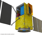
The Amazônia-1 satellite (or SSR-1), scheduled to launch in December 2017,[1] is the first earth observation satellite entirely developed by Brazil.[2]
Operations will be joint with the CBERS-4 satellite.[3]
Background
In the early 90s, the design of SSR satellites, Amazônia-1 precursor, was revised and INPE technicians proposed replacing the polar orbit by an equatorial orbit, and this proposal was accepted. That made sense at that time as Brazil already had coverage by polar orbit with the CBERS satellites.
The SSR-1 of the project suffered several delays start, either by lack of resources, whether by barriers in the disputes of the bids. The effective start, only occurred in 2001 when a contract was signed for the development of multi-mission platform specifically (at the time) for this purpose.
In 2001, a joint study between the INPE and DLR was published, found that most of the SSR-1 requirements can be met by two sensors:. A camera VIS / NIR and other MIR [4] However, with the publication PNAE review in 2005, the SSR-1 ceased to be a priority.
Update
Between September and October 2012, a structural model of the Amazônia-1 satellite was subjected to a series of vibration test.
In the latest review of the PNAE, published in January 2013, the Amazônia-1 resurfaced with this name, and even successors planned (Amazon-1B in 2017 and Amazon-2 in 2018), however, remains the intention of use in orbit polar and the release dates of these satellites can not be maintained. A delay of two years, at least, already exists in the Amazônia-1 schedule.[5]
Features
The current design features are as follows:
- Orbit: polar orbit
- Period of Earth imaging: 4 days
- Optical sighting wide imaging (camera with 3 bands in the VIS and NIR 1 band)
- Observation range: 720 km with 40 meter resolution.
- Platform: Multimission Platform (PMM)
- Weight: 500 kilograms (1,100 lb)
Instruments
- Advanced Wide Field Imager (AWFI),[6] 40m resolution camera
Amazônia - 2
The Amazônia - 2 satellite is planned for launch in 2018 to replace its predecessor.[7]
See also
References
- 1 2 "Mission Summary - Amazonia-1". CEOS Database. CEOS. Retrieved 2016-02-18.
- ↑ "Amazônia-1 será o primeiro satélite totalmente desenvolvido pelo Brasil" [Amazonia-1 will be the first satellite developed entirely by Brazil] (in Portuguese). Retrieved April 9, 2013.
- ↑ "Inpe adquire componentes para o satélite Amazônia-1" [INPE acquires components for the satellite Amazonia-1] (in Portuguese). Retrieved April 9, 2013.
- ↑ Rudorff, Bernardo (10/04/2003). O SATÉLITE DE SENSORIAMENTO REMOTO SSR-1 PARA MONITORAMENTO DA AMAZÔNIA (PDF). INPE. Retrieved 15 May 2016.
- ↑ PROGRAMA NACIONAL DE ATIVIDADES ESPACIAIS 2012-2021 (PDF). Brazilian Space Agency. 22/01/2013. Retrieved 15 May 2016.
- ↑ "The Ceos Database : Instrument Summary - Awfi". Database.eohandbook.com. Retrieved 2014-03-08.
- ↑ "Plano Diretor 2011 - 2015" (PDF). Inpe.br. Retrieved 2014-03-08.
