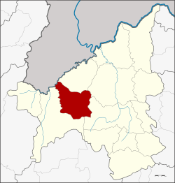
Phu Ruea District
| Phu Ruea ภูเรือ | |
|---|---|
| Amphoe | |
 Amphoe location in Loei Province | |
| Coordinates: 17°27′18″N 101°21′48″E / 17.45500°N 101.36333°ECoordinates: 17°27′18″N 101°21′48″E / 17.45500°N 101.36333°E | |
| Country | Thailand |
| Province | Loei |
| Seat | Nong Bua |
| Amphoe established | 1968 |
| Area | |
| • Total | 880.0 km2 (339.8 sq mi) |
| Population (2009) | |
| • Total | 21,182 |
| • Density | 23.5/km2 (61/sq mi) |
| Time zone | ICT (UTC+7) |
| Postal code | 42160 |
| Geocode | 4207 |
Phu Ruea (Thai: ภูเรือ; IPA: [pʰūː rɯ̄a]) is a district (amphoe) in the western part of Loei Province, northeastern Thailand.
History
The government split off some part of Tha Li, Mueang Loei, and Dan Sai Districts and made them into the minor district (king amphoe) Phu Ruea on 15 October 1968 and made it a subordinate of Dan Sai.[1] It was upgraded to a full district on 1 April 1974.[2]
Geography
The district is named after Phu Ruea, an important mountain in the area.
Neighboring districts are (from the northeast clockwise) Tha Li, Mueang Loei, Wang Saphung, Phu Luang of Loei Province, Lom Kao of Phetchabun Province, and Dan Sai of Loei again. To the northwest is Xaignabouli Province of Laos.
To the north of the district is the Phu Ruea National Park,[3] to the south the Phu Luang Wildlife Sanctuary.
The northwestern part of the district reaches the southern end of the Luang Prabang Range mountain area of the Thai highlands.[4]
Administration
The district is divided into six sub-districts (tambon), which are further subdivided into 47 villages (muban). Phu Ruea is a sub-district municipality (thesaban tambon) which covers parts of the tambon Nong Bua. There are further six tambon administrative organizations (TAO).
| No. | Name | Thai | Villages | Pop.[5] |
|---|---|---|---|---|
| 1. | Nong Bua | หนองบัว | 8 | 5,509 |
| 2. | Tha Sala | ท่าศาลา | 7 | 2,746 |
| 3. | Rong Chik | ร่องจิก | 10 | 4,842 |
| 4. | Pla Ba | ปลาบ่า | 7 | 3,226 |
| 5. | Lat Khang | ลาดค่าง | 6 | 2,078 |
| 6. | San Tom | สานตม | 9 | 2,781 |
References
- ↑ ประกาศกระทรวงมหาดไทย เรื่อง แบ่งท้องที่ตั้งเป็นกิ่งอำเภอ (PDF). Royal Gazette (in Thai). 85 (944 ง): 3025. October 15, 1968.
- ↑ พระราชกฤษฎีกาตั้งอำเภอเขาวง อำเภอเชียงม่วน อำเภอดอนตาล อำเภอชาติตระการ อำเภอภูเรือ อำเภอเคียนซา อำเภอน้ำโสม อำเภอหนองวัวซอ และอำเภอน้ำยืน พ.ศ. ๒๕๑๗ (PDF). Royal Gazette (in Thai). 91 (54 ก special issue): 30–33. March 28, 1974.
- ↑ "Phu Ruea National Park". Department of National Parks (DNP) Thailand. Retrieved 2 October 2015.
- ↑ ดร.กระมล ทองธรรมชาติ และคณะ, สังคมศึกษา ศาสนาและวัฒนธรรม ม.1, สำนักพิมพ์ อักษรเจริญทัศน์ อจท. จำกัด, 2548, หน้า 24-25
- ↑ "Population statistics 2009". Department of Provincial Administration.
External links
- http://www.amphoe-phurua.com/ Website of district (Thai)
- amphoe.com (Thai)