Thai highlands
| Thai Highlands เขตภูเขา (ประเทศไทย) | |
|---|---|
| Natural region | |
|
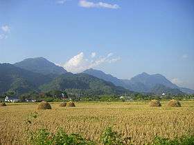
Rice being harvested in Wang Nuea District, Lampang province. The mountains in the background are part of the Phi Pan Nam Range. | |
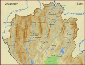 Map of the Thai highlands | |
| Coordinates: 18°30′00″N 98°30′00″E / 18.50000°N 98.50000°ECoordinates: 18°30′00″N 98°30′00″E / 18.50000°N 98.50000°E | |
| Area | Northern Thailand, and parts of Tak and Sukhothai provinces |
| Area | |
| • Total | 107,000 km2 (41,000 sq mi) |
| Population (2009) | |
| • Total | 6,300,000 |
| • Density | 59/km2 (150/sq mi) |
| Time zone | UTC+7 |

The Thai Highlands or Hills of Northern Thailand, Thai: เขตภูเขา (ประเทศไทย), are a mountainous natural region in the north of Thailand. Its mountain ranges are part of the system of hills extending through Laos, Burma and China and linking to the Himalayas, of which they may be considered foothills.
The highlands of the North of Thailand are characterized by a pattern of generally steep hill ranges, intermontane basins and alluvial gorges. Elevations are generally moderate, little above 2,000 metres (6,600 ft) for the highest summits. There is a wide range of elevations though, with floors ranging between 200 and 500 metres (660 and 1,640 ft) above sea level. Towards the Lao border, the divide to the Mekong basin becomes higher with peaks occasionally rising above 1,500 metres (4,900 ft) and streams flowing in narrow steep valleys.[1]
The climate is typical of tropical mountains with clearly delineated wet and dry seasons. Winter temperatures can be cool with frosts occurring most years at higher elevations, but no snow even on the highest peaks.
The region of the Thai Highlands encompasses the nine administrative provinces of Northern Thailand, based on the six-region system, as well as parts of Tak and Sukhothai provinces.
Some areas of the highlands have very little human habitation.
Geography
Except for the Daen Lao Range (ทิวเขาแดนลาว) at the far northern edge, all ranges in the north of Thailand are roughly aligned from north to south. They are linked to a wide system of ranges in neighboring Burma and Laos that do not have a specific name for the whole, "Thai highlands" being the term generally restricted to the Thai area.[2] Broadly defined, and based on their geological composition, there are two mountainous subsystems in Northern Thailand:
- In the western part the ranges stretching southwards from the Daen Lao Range, in the southern region of the Shan Hills or Shan Highland, with the two parallel mountain chains of the Thanon Thong Chai Range (เทือกเขาถนนธงชัย). This area has the highest elevations, with Doi Inthanon, the highest point in Thailand, reaching 2,565 metres (8,415 ft). The Dawna Range (ทิวเขาดอยมอนกุจู) forms the western border of Thailand between Mae Hong Son and the Salween River,[3]
- The remaining mountainous region of parallel ranges that extend into northern Laos includes the Khun Tan Range (ทิวเขาขุนตาน), the Phi Pan Nam Range (ทิวเขาผีปันน้ำ), the Phlueng Range (ทิวเขาพลึง) as well as the western part of the Luang Prabang Range (ทิวเขาหลวงพระบาง).[4]
A great part of the highland area is drained by rivers Ping, Wang, Yom and Nan, all tributaries of the Chao Phraya River flowing in a roughly southern direction. The ranges separating the main rivers are generally steep, high and continuous. Towards the east, as well as in the Wang and Yom drainage basins, they are lower. The Pai River in the northwest flows westwards into the Salween and the northeastern part is drained by rivers of the Mekong basin, like the Kok and Ing.
|

Geology
Geologically in the southern subranges of the Shan Hills layers of alluvium are superimposed on hard rock. The ranges closer to Laos consist of Permo-Carboniferous limestone, which makes for a more jagged and steep relief, despite the more moderate height.[5] Most of the Thai highlands are part of the Shan-Thai Terrane, a tectonic plate.[6]
Environment and human impact
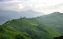
The natural environment of the hills used to be dense montane rain forest. Swidden agricultural practices and logging have much reduced the pristine old-growth forest areas which have been replaced by secondary forest.[7][8]
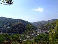
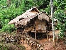
For centuries the Thai highlands have been inhabited with hill tribes mostly from Chinese or Tibeto-Burman descent, such as the Akha, Yao, Lahu, Khmu, Hmong and Lisu.[9] These human groups immigrated into this relatively empty region fleeing persecution or harsh central rule in their respective environments, as well as seeking new land for their shifting agricultural productions system. For the past decades these groups have been undergoing a process of integration into the Thai mainstream.
Owing to the unrest in Burma, some refugee camps have been established for the cross-border refugees in the Thai highlands.[10] Certain Kayah and Karen communities, like the 'Long-necked Karen', are regularly visited by organized tourist groups.[11]
At higher elevations, above about 1,000 metres (3,300 ft), one of the main crops was opium until the 1990s, when the combined effects of development became evident - from the construction of roads into the remote area, increasingly efficient policing, and opium replacement programs.[12]
Yearly wildfires are started on purpose by local farmers during the dry season in different areas of Northern Thailand. Often speculators also hire people to set forests on fire in order to claim land title deeds for the areas that have become "degraded forest".[13] The smoke produced by these fires is the main cause of the intense seasonal air pollution in the Thai highlands, also known as the "northern haze".[14] Fires also contribute to the floods in the country by completely denuding the undergrowth of the woods[15] and the dry forest soil leads to lower water intake for the trees to extract when the rains arrive.[16]
Presently large tracts of the mountains are covered with a mixed vegetation resulting from the capacity of the efficient shifting agricultural system being exceeded. As a result, large areas end up becoming dominated by Imperata cylindrica grass, which is used throughout Thailand as roofing material. Cattle can graze on the grass to an extent, as agricultural science research in the 1970s defined.[17] The longer term environmental care of the region is associated with forestry and in the lower reaches, perennial fruit like peaches and other trees.[18] Also some projects for the restoration of forest cover have been undertaken in ecologically degraded areas.[19]
See also

- Doi Inthanon, the highest mountain in Thailand
- Doi Nang Non, a karstic formation in Chiang Rai province
- Golden Triangle (Southeast Asia)
- Deforestation in Thailand
- Tribal Museum in Chiang Mai
- Western Forest Complex
- Southeast Asian Massif
- Zomia (geography)
References
- ↑ Heritage Thailand, Geography 4
- ↑ The Physical Geography of Southeast Asia, Avijit Gupta
- ↑ Northern Thailand
- ↑ ดร.กระมล ทองธรรมชาติ และคณะ, สังคมศึกษา ศาสนาและวัฒนธรรม ม.1, สำนักพิมพ์ อักษรเจริญทัศน์ อจท. จำกัด, 2548, หน้า 24-25
- ↑ Geology of Thailand - Ministry of Natural Resources and Environment, Bangkok
- ↑ Bunopas, Sangad; Paul Vella (17–24 November 1992). "Geotectonics and Geologic Evolution of Thailand" (PDF (Acrobat 7.x) 1.8 MB). National Conference on "Geologic Resources of Thailand: Potential for Future Development". Department of Mineral Resources, Bangkok. pp. 209–229. Retrieved 10 August 2014.
Thailand consists of Shan–Thai and Indochina Microcontinents or Terranes welded together by the subsequently deformed Nan Suture.... During the Middle Triassic Shan–Thai sutured nearly simultaneously to Indochina and to South China, the continent–continent collision being a part of the Indosinian Orogeny and Indochina tended to underthrust Shan–Thai.
- ↑ Secondary forests in swidden agriculture in the highlands of Thailand
- ↑ Gajaseni, Jiragorn; Jordan, Carl F. (1 January 1990). "Decline of Teak Yield in Northern Thailand: Effects of Selective Logging on Forest Structure". Biotropica. 22 (2): 114–118. doi:10.2307/2388402. JSTOR 2388402.
- ↑ "Thailand travel guide and holiday planner.".
- ↑ TBBC
- ↑ The Politics of Ethnic Tourism in Northern Thailand
- ↑ Opium Reduction and Highland Development: Thailand Case Study
- ↑ PCL., Post Publishing. "Bangkok Post".
- ↑ Mushroom Research Center
- ↑ "national forest policy review-thailand".
- ↑ "Underlying Causes of Deforestation". UN Secretary-General’s Report.
- ↑ Lindsay Falvey, Cattle and Sheep in Northern Thailand, Chiang Mai (1979). 104pp
- ↑ "Welcome to The GEF Small Grants Programme".
- ↑ "REHABILITATION OF DEGRADED SITES - Unasylva 207".
External links
| Wikimedia Commons has media related to Thai highlands. |
 Chiang Mai travel guide from Wikivoyage
- Opium, Power, People: Anthropological Understandings of an Opium Interdiction Project in Thailand
- Dubious Development Concepts in the Thai Highlands: The Chao Khao in Transition
- "Northern Thailand-Laos moist deciduous forests". Terrestrial Ecoregions. World Wildlife Fund.
- Cultural Landscape of the northern Region of Thailand (ภาคเหนือ)
- Golden Triangle and beyond
- Speciation and Radiation in a River
- Premier orders urgent action to tackle haze in North