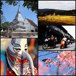
Loei Province
| Loei เลย | ||
|---|---|---|
| Province | ||
 | ||
| ||
| Motto: City of the sea of mountains, coldest place in Siam, with beautiful flowers of three seasons | ||
 Map of Thailand highlighting Loei Province | ||
| Coordinates: 17°29′12″N 101°43′10″E / 17.48667°N 101.71944°ECoordinates: 17°29′12″N 101°43′10″E / 17.48667°N 101.71944°E | ||
| Country | Thailand | |
| Capital | Loei town | |
| Government | ||
| • Governor | Khumphon Banthaothuk (since October 2016) | |
| Area | ||
| • Total | 11,424.6 km2 (4,411.1 sq mi) | |
| Area rank | Ranked 14th | |
| Population (2014) | ||
| • Total | 634,513 | |
| • Rank | Ranked 40th | |
| • Density | 55.33/km2 (143.3/sq mi) | |
| • Density rank | Ranked 72nd | |
| HDI | ||
| • HDI (2009) | 0.731 (42nd) | |
| Time zone | ICT (UTC+7) | |
| Area code(s) | 042 | |
| ISO 3166 code | TH-42 | |
| Vehicle registration | เลย | |
| Website |
www | |

Loei (Thai: เลย, pronounced [lɤ̄ːj]), in Isan, is one of the most sparsely populated provinces (changwat) of Thailand. Neighboring provinces are (from east clockwise) Nong Khai, Udon Thani, Nongbua Lamphu, Khon Kaen, Phetchabun, Phitsanulok. In the north it borders Xaignabouli and Vientiane Province of Laos.
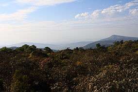
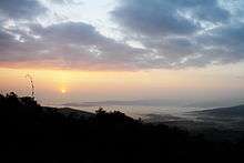
The city of Loei is surrounded by mountain ranges whose summits are covered by fog and abundant with varied flora. The best known mountains in the province are Phu Kradueng, Phu Luang, and Phu Ruea.
Geography

The province is dotted with mountains, such as Phu Kradueng and Phu Ruea, while the seat of provincial government, Loei, is in a fertile basin. The Loei River, which flows through the province, is a tributary of the Mekong, which forms part of the northern boundary of the province with neighboring Laos. Phu Thap Buek, the highest mountain of the Phetchabun Range, is in the province.[1]
The mountain of Phu Kradueng is part of the Phu Kradueng National Park. Other national parks include Phu Hin Rong Kla, Phu Ruea, Phu Pha Man, and Phu Suan Sai (also known as Na Haeo).
The Phu Luang Wildlife Sanctuary is in the province.
The western part of the province reaches the southern end of the Luang Prabang Range mountain area of the Thai highlands.[2]
History
According to tradition, Loei was founded by people from Chiang Saen, the capital of Lan Na. Khun Pha Muang founded the village of Dan-kwa, and Bang Klang Hao founded Dan Sai. Drought and disease later led to the villagers move to the site of present-day Loei. In 1907 King Chulalongkorn (Rama V) created Loei Province.
Symbols
The seal of the province shows the stupa at Phra That Si Song Rak, which was built in 1560 by King Maha Chakrapat of the Ayutthaya Kingdom and King Chai Chetha of Lan Xang as a symbol of friendship between the two kingdoms.[3] The provincial tree is the Khasi pine (Pinus kesiya).
The provincial slogan is "city of the sea of mountains, coldest place in Siam, with beautiful flowers of three seasons."[4]
Economy
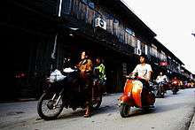
Agriculture drives Loei's economy. Macadamia nuts, passion fruit, and Arabica coffee are grown in the highlands; bananas, sesame, and rubber on the plains. Loei is a budding ecotourism destination due to its natural beauty and amalgam of northern and northeastern cultures.[5]
Wang Saphung District is the site of a large open pit gold mine that employs many locals. The locality has been the site of a long-standing dispute as well as physical conflict between the villagers of Ban Na Nong Bong and its environs and Tungkum Limited, a subsidiary of Tongkah Harbour PCL. Tungkum's gold mining operation has been accused in the courts of environmental destruction.[6]
Administrative divisions

The province is divided into 14 districts (amphoe). The districts are further subdivided into 89 sub-districts (tambon) and 839 villages (muban).
Tourism


- Phu Kradueng National Park (อุทยานแห่งชาติภูกระดึง)[7]

- Phu Ruea National Park (อุทยานแห่งชาติภูเรือ)[8]
- Phu Suan Sai National Park (อุทยานแห่งชาติภูสวนทราย)[9]

- Loei Cultural Centre (ศูนย์วัฒนธรรมจังหวัดเลย) A two-storey building, displaying Loei's religion, traditions, and way of life.[10]
Chaopho Kut Pong Shrine and the City Pillar Shrine (ศาลเจ้าพ่อกุดป่องและศาลหลักเมือง)The city pillar was made of the golden shower wood elaborately carved into a lotus shape at its top and gilded with gold leaf on black lacquer. Its height is 139 centimetres (55 in).
Chaloem Phra Kiat Public Park, Pa Loeng Yai (สวนสาธารณะเฉลิมพระเกียรติฯ ป่าเลิงใหญ่) A two rai public park on the Loei River. There is a decorative garden with flowers and decorative plants.
Office of the Loei Tourism Coordination Centre (อาคารที่ทำการศูนย์ประสานงานการท่องเที่ยวจังหวัดเลย) Previously the city hall and Mueang Loei District office. The Loei Provincial Council of Culture collected the king's chair at this place. The Fine Arts Department has registered it as a national ancient monument for preservation.
Wat Tham Pha Pu or Phiang Din cave (วัดถ้ำผาปู่ หรือ ถ้ำเพียงดิน), Houses the remains of Luangpu Khamdi Paphaso, who discovered this place. The temple is a grand cave within a stone mountain. There are Buddha images enshrined in the cave, as well as stalagmites and stalactites.
Phu Pha Lom Forest Park (วนอุทยานภูผาล้อม) Steep limestone mountains with various pointed summits similar to a wall surrounding the virgin forest in the middle. There are various kinds of plants, herbs, sightseeing points, and caves as well as, Bo Nam Sap or Nam Phut, which is a sacred seepage pond.
Si Khun Mueang temple (วัดศรีคุณเมือง) This temple is a collection venue of Lanna and Lan Chang arts. The ubosot's roof is in many layers reflecting Lanna-style. There are also many objects of art such as a carved Buddha image gilded with gold leaf on black lacquer in the forgiving posture of the Lan Chang style.
Phu Khwai Ngoen Buddha's footprint (พระพุทธบาทภูควายเงิน) The Buddha's footprint is 120 centimetres long and 65 centimetres wide, enshrined on a whetstone and was registered as a national ancient monument in 1935.
Phu Khok Ngio Buddha statue (พระใหญ่ภูคกงิ้ว) A walking Buddha image in the blessing posture, cast of fibre and golden resin combined. It was cast by the Second Army Area Command and the people as a form of merit making for the king and queen.
Thai Dam Cultural Village (หมู่บ้านวัฒนธรรมไทยดำ) Thai Dam people migrated from Chiang Khwang Town, Laos in 1905 to settle at Ban Na Pa Nat. At present, the Thai Dam culture is still preserved.
Crown Princess's Sirindhorn Art Centre (ศูนย์ศิลป์สิรินธร) A venue displaying paintings of students who have gained popularity at both national and international levels. Moreover, it is a source of knowledge on arts and culture, including both permanent and rotating exhibition halls, and an arts training building.
Phu Luang Wildlife Sanctuary (เขตรักษาพันธุ์สัตว์ป่าภูหลวง) Phu Luang means "large mountain" or the "mountain of the king". On the east of Phu Luang, dinosaur footprints on the rock, aged more than 120 million years, were discovered. The most distinguished ones on Phu Luang are Pinus merkusii and Kesiya pine forests, savanna on plains, mounds, and stone terraces.
Pha Ya cave (ถ้ำผายา) is inside Wat Tham Pha Ya at Ban Mai Santi Tham, Tambon Na Dok Kham. Inside the cave is a flock of millions of insect-eating bats.
Suan Hin Pha Ngam or Thailand's Kunming (สวนหินผางาม หรือ คุนหมิงเมืองไทย) A limestone garden aged around 230-280 million years, occurring from the aggregation of beach deposits. Then, an uplift of the earth's crust, together with millions of years of natural rot have made this mountain strangely beautiful, similar to the stone garden in Kunming, Yunnan China.
Mahoran Cave (ถ้ำมโหฬาร) A large cave whose entrance enshrines a Buddha image in subduing Mara posture. The area within the cave is quite large consisting of stalactites and stalagmites, as well as, caves in smaller sizes. A Buddha's footprint was also found on the wall of the cave.
Phothisat Cave (ถ้ำโพธิสัตว์) or Thailand's Guilin is within the compound of Wat Tham Phothisat. It is a complex cave.
Piang Din Waterfall (น้ำตกเพียงดิน) is 4 kilometres (2.5 mi) beyond Suan Hin Pha Ngam. The waterfall is at the end of the asphalt road.
Phrathat Si Song Rak (พระธาตุศรีสองรัก) Its architecture is in the Lan Chang style. Phrathat, a stupa containing the Buddha's relics, is 19.19 metres high and 10.89 metres wide with a square base of 12 redented corners. Moreover, within the compound of the temple is enshrined a Buddha image canopied by a seven-headed Naga in the Tibetan-style.
Neramit Wipatsana temple (วัดเนรมิตวิปัสสนา) Both the ubosot and chedi are constructed of laterite. A replica of Phra Phutthachinnarat is enshrined as the main image.
Phi Ta Khon Museum (พิพิธภัณฑ์บ้านผีตาโขน) An educational attraction for those interested in the Bun Luang and Phi Ta Khon Festivals. There is an ubosot reflecting the skills of local craftsmen as well as a replica of Phrathat Si Song Rak.
Pho Chai Na Phueng temple (วัดโพธิ์ชัยนาพึง) Enshrined within the abbot's cell is the Prachao Ong Saen Buddha image, an ancient image of the town for many generations. On the outside of the ubosot are paintings which were created in 1916.
The Thai-Lao Friendship Bridge (สะพานมิตรภาพน้ำเหืองไทย-ลาว) A bridge crossing the Hueang River connecting Thailand and Laos.
Festivals
Dok Fai Ban Makham Wan Mueang Loei Red Cross Fair (งานกาชาดดอกฝ้ายบาน มะขามหวานเมืองเลย) held in front of Loei City Hall 1–9 February every year. Parades from various districts, as well as cultural performances are highlights of the fair.

Thai–Lao Songkran Festival (งานประเพณีสงกรานต์ไทย-ลาว) held in Tha Li District 12–15 April of every year. Large numbers of Lao participate in the festival.
Bun Bang Fai Lan Festival (งานประเพณีบุญบั้งไฟล้าน) held within the compound of Wat Erawan Phatthanaram, Erawan District on the full moon of the 6th lunar month or during May of every year. It is Loei's biggest festival.
Phrathat Si Song Rak Fair (งานนมัสการพระธาตุศรีสองรัก) an annual event organised on the full moon of the 6th lunar month, around the end of April until early-May to celebrate Phrathat Si Song Rak, a significant place of worship of the town.
Bun Luang Festival and Phi Ta Khon (งานประเพณีบุญหลวง และการละเล่นผีตาโขน) held annually in Dan Sai District on Saturday–Sunday after the full moon day of the 6th lunar month, and after paying respect to Phrathat Si Song Rak. Phi Ta Khon is a local activity of Dan Sai and Na Haeo Districts, relating to the belief and faith in Buddhism and the spirit of ancestors. Phi Ta Khon parades are organised in the Bun Luang Festival, an annual local merit-making ceremony. On the first day, the Phra Upakhut procession proceeds from the Man River to Wat Phon Chai and on the next day, it enters the town, while the Phi Ta Khon participants throw their costumes and accoutrements into the Man River. After that, a series of all 13 chapters of the Great Birth Sermon will be read.
Chiang Khan's End of Buddhist Lent Festival (งานประเพณีออกพรรษาอำเภอเชียงคาน) organised in front of Chiang Khan District Office on the full moon day of the 11th lunar month every year. There is the Prasat Phueng procession, long-boat races, Ruea Kap races, illuminated boat contest, Tak Bat Devo, and various local cultural shows and entertainment in the festival.
Sea of Fog and Beautiful Flower Blossom on Phu Ruea (Winter Flowers Fair, Phu Ruea District) (เทศกาลหมอก ดอกไม้งาม บานสะพรั่งภูเรือ) is held on the grounds in front of Phu Ruea District Office during the New Year's Festival, around 31 December–3 January every year. Activities in the festival include a temperate plant fair, floral float parade, temperate flowers and decorative plants contests, Mae Khaning evening party, dances in the winter breeze.

References
- ↑ "Ban Thap Boek". Tourism Authority of Thailand (TAT). Retrieved 6 May 2016.
- ↑ ดร.กระมล ทองธรรมชาติ และคณะ, สังคมศึกษา ศาสนาและวัฒนธรรม ม.1, สำนักพิมพ์ อักษรเจริญทัศน์ อจท. จำกัด, 2548, หน้า 24-25
- ↑ "Loei". THAILEX Travel Encyclopedia. Retrieved 5 June 2016.
- ↑ "About Loei". Tourist Authority of Thailand (TAT). Retrieved 5 June 2016.
- ↑ "Loei: General Info". Tourist Authority of Thailand (TAT). Retrieved 5 June 2016.
- ↑ Wannasiri, Sutharee; Abbott, Kingsley (2016-06-05). "Struggle against mining violations leaves activists exposed". Bangkok Post. Retrieved 5 June 2016.
- ↑ "Phu Kradueng National Park". Department of National Parks (DNP). Retrieved 5 June 2016.
- ↑ "Phu Ruea National Park". Department of National Parks (DNP). Retrieved 5 June 2016.
- ↑ "Phu Suan Sai National Park". Department of National Parks (DNP). Retrieved 5 June 2016.
- ↑ "Loei Cultural Center". Tourism Authority of Thailand (TAT). Retrieved 5 June 2016.
External links
| Wikimedia Commons has media related to Loei. |
 Loei travel guide from Wikivoyage
- Provincial website
