Anangpur Dam
| Anangpur Dam | |
|---|---|
 Anangpur Dam | |
| Location | Delhi and Haryana |
| Coordinates | 28°27′45″N 77°15′52″E / 28.46250°N 77.26444°ECoordinates: 28°27′45″N 77°15′52″E / 28.46250°N 77.26444°E |
| Construction began | 8th century |
| Dam and spillways | |
| Impounds | local nallah (stream) |
| Height | 7 m (23 ft) |
| Length | 50 m (164 ft) |
| Reservoir | |
| Creates | Water supply & Irrigation |
The Anangpur Dam, located close to the Anagpur village (also called Arangpur) in Faridabad district of Haryana, India, is 2 kilometres (1.2 mi) away from the more famous Surajkund. This unique Indian hydraulic engineering structure was built during the reign of King Anangpal of the Tomar dynasty in 8th century. It is approachable by road from Delhi from the Delhi - Mathura road. The ruins of the fortifications found in Anangpur village establishes by an inference that it was built by Anangpal as part of the Lal Kot that was developed as the first city of Delhi in the 8th century.[1][2][3]
Topography
A local nala (stream) originating in the Aravalli hills was intercepted by building a dam at a chasm to store rain water. It is basically a water harvesting structure meant to store rain water during the monsoon season for beneficial uses of irrigation.[1][2]
History
Anagpal I moved his fiefdom to the south of the Aravalli hills, south of the present day Delhi at the far end of the 10th century. Within the boundaries of the present day Haryana, on the border with Delhi, they built the Surjakund reservoir near Surjakund village and another dam in its close vicinity near the Arangpur village as the Anangpur dam. It is said that Anangpal who built Surjakund and Arangpal (also known as the builder of Lal Kot, called the first city of Delhi) who built Arangpur dam belonged to the same dynasty but belonged in different periods.[4]
Structure
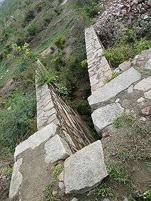
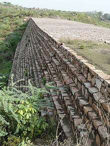
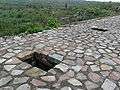
The ancient and solid gravity dam structure, a pre-Islamic structure that fords a local nala (stream) is 7 metres (23 ft) in height and 50 m (160 ft) in length between the two banks. It has been built with quartzite stones (locally available), duly chiselled and dressed, as a regular dam section with downstream base width increasing in steps with depth up to the foundation. It has entry manholes from the top of the dam, which lead into the body of the dam for inspection and control of flow through sluices for downstream uses. The intake entry into the sluice is on the upstream side. The downstream outlet end leads to the flat terrain below the dam at the ground level. The reservoir created by the dam is mostly silted over the centuries, but it is said to be in use.[2][5]
Access
Anagpur, which is 1 kilometre (0.62 mi) from the dam, is 19 km (12 mi) from Delhi city and is approachable from Qutub Minar and Surajkund. But the access to the dam is through a path from the Anagpur village, which goes through flat pastureland and then over a rocky forested hill.[1][2]
Gallery
-

Downstream view of the dam
-
Gallery entry into the dam
-

Steps into the gallery inside the dam
-
.jpg)
Sluice inlet in the dam
References
| Wikimedia Commons has media related to Anagpur Dam. |
- 1 2 3 Sharma, Y.D. (2001). Delhi and its Neighbourhood. Surjakund and Anagpur Dam. New Delhi: Archaeological Survey of India. pp. 100–. Retrieved 2009-09-05.
Page 100:Suraj Kund lies about 3 km (1.9 mi) south-east of Tughlaqabad in district Gurgaon---The reservoir is believed to have been constructed in the tenth century by King Surjapal of Tomar dynasty, whose existence is based on Bardic tradition. Page 101: About 2 km south-west of Surajkund, close to the village of Anagpur (also called Arangpur is a dam ascribed to Anagpal of the Tomar Dynasty, who is also credited with building the Lal Kot
- 1 2 3 4 Peck, Lucy (2005). Delhi - A thousand years of Building. Suraj Kund dam and Surajkund tank. New Delhi: Roli Books Pvt Ltd. p. 29. ISBN 81-7436-354-8. Retrieved 2009-09-05.
One of the two significant structures in the area, the dam lies about 1 km [0.62 mi] to the north of the Anangpur village. A path from the main village street will lead you in to flat pastureland. Head for the small rocky hill ahead of you and climb over it. On the other side is another flat area, rather thickly covered in thorn trees. It is worth finding a way through them to the dam that straddles the gap between the two nearby hills. The dam is an impressive edifice 50 m wide and 7 m high [164 ft × 23 ft high] built from accurately hewn quartzite blocks.---There is a passage for the egress of water at the level of the ground on the dammed side. The flat land across which you have walked is clearly caused by centuries of silt deposits in the lake that once existed behind this dam. The land around has been vwey heavily quarried recently, so further archaeological finds are unlikely.
- ↑ "Anangpur Dam". Archived from the original on 2009-11-25. Retrieved 2009-09-07.
- ↑ Madan Mohan. "Spatial Data Modeling in GIS for Historical Restoration and Conservation of Cultural Heritage of Seven Cities of Delhi" (pdf). Department of Geography, Faculty of Natural Sciences, Jamia Millia Islamia (Central University) New Delhi, India. Retrieved 2009-09-07.
- ↑ "Paani Yatra Challenge of the Balance" (PDF). Hauz-i-Shamsi. Centre for Science and Environment: Orientation programme for Oslo University students. 2002-12-31. p. 31. Archived from the original (pdf) on 2008-11-17.