Anna Maria, Florida
| Anna Maria, Florida | ||
|---|---|---|
| City | ||
|
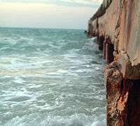
An erosion prevention pier on Anna Maria Island, Florida. | ||
| ||
| Motto: "Manatee County Florida" | ||
 Location in Manatee County and the state of Florida | ||
| Coordinates: 27°31′49″N 82°44′4″W / 27.53028°N 82.73444°WCoordinates: 27°31′49″N 82°44′4″W / 27.53028°N 82.73444°W | ||
| Country |
| |
| State |
| |
| County | Manatee | |
| Settled | 1892 | |
| Incorporated (city) | 1925 | |
| Government | ||
| • Type | Strong Mayor-Commission | |
| • Mayor | Dan Murphy | |
| • Commission Chair | Doug Copeland | |
| Area | ||
| • Total | 1 sq mi (2.5 km2) | |
| • Land | 0.8 sq mi (2 km2) | |
| • Water | 0.2 sq mi (0.5 km2) | |
| Elevation | 0 ft (0 m) | |
| Population (2010) | ||
| • Total | 1,503 | |
| • Density | 1,503/sq mi (725.6/km2) | |
| Time zone | Eastern (EST) (UTC-5) | |
| • Summer (DST) | EDT (UTC-4) | |
| ZIP code | 34216 | |
| Area code(s) | 941 | |
| FIPS code | 12-01475[1] | |
| GNIS feature ID | 0277889[2] | |
Anna Maria, is a city in Manatee County, Florida, United States. The population was 1,814 at the 2000 census. According to the 2005 U.S. Census Bureau's estimates, the city grew slightly to 1,867.[3] The city occupies the northern part of Anna Maria Island and is one of three municipalities on the island. The others are Holmes Beach in the center and Bradenton Beach in the south.
Anna Maria is part of the Bradenton–Sarasota–Venice Metropolitan Statistical Area.
Etymology
Ponce de Leon was said to have named the island for Maria Anna von der Pfalz-Neuburg, the queen of Charles II of Spain, the sponsor of his expedition. In the past, pronunciation of the name differed: old timers said "Anna Mar-EYE-a," but most people today say "Anna Mar-EE-a." [4] According to a regional historian of note, Lillian Burns, the daughter of the early land developer, Owen Burns, the correct pronunciation of the name of the island by its early settlers was, an-na ma-rye-a, since it was named for the strong winds occurring in the area, using the German term for the wind, Maria.[5] This pronunciation may be heard in the popular song, They Call The Wind Maria, from the musical, Paint Your Wagon.
History
In 1892, George Emerson Bean homesteaded the north 160 acres (0.65 km2) of Anna Maria Island. After his death in 1898, the land went to his son, George Wilhelm Bean, who partnered with Charles Roser, a wealthy real estate developer from St. Petersburg, to form the Anna Maria Beach Company to develop the area.[6]
On September 10, 2006, an earthquake occurred in the Gulf of Mexico which was felt on the beach but caused no damage.
Geography
Anna Maria is located at 27°31′49″N 82°44′04″W / 27.530214°N 82.734370°W.[7]
According to the United States Census Bureau, the city has a total area of 1.0 square mile (2.6 km2), of which 0.8 square miles (2.1 km2) is land and 0.2 square miles (0.52 km2) (21.21%) is water.
Demographics
| Historical population | |||
|---|---|---|---|
| Census | Pop. | %± | |
| 1930 | 77 | — | |
| 1940 | 158 | 105.2% | |
| 1950 | 345 | 118.4% | |
| 1960 | 690 | 100.0% | |
| 1970 | 1,137 | 64.8% | |
| 1980 | 1,537 | 35.2% | |
| 1990 | 1,744 | 13.5% | |
| 2000 | 1,814 | 4.0% | |
| 2010 | 1,503 | −17.1% | |
| Est. 2015 | 1,669 | [8] | 11.0% |
As of the census[1] of 2000, there were 1,814 people, 897 households, and 572 families residing in the city. The population density was 2,338.3 inhabitants per square mile (897.9/km²). There were 1,538 housing units at an average density of 1,982.6 per square mile (761.3/km²). The racial makeup of the city was 98.18% White, 0.33% African American, 0.11% Native American, 0.28% Asian, 0.44% from other races, and 0.66% from two or more races. Hispanic or Latino of any race were 2.48% of the population.
There were 897 households out of which 14.3% had children under the age of 18 living with them, 55.4% were married couples living together, 6.5% had a female householder with no husband present, and 36.2% were non-families. 29.9% of all households were made up of individuals and 16.4% had someone living alone who was 65 years of age or older. The average household size was 2.02 and the average family size was 2.46.
In the city the population was spread out with 12.5% under the age of 18, 3.3% from 18 to 24, 14.9% from 25 to 44, 36.2% from 45 to 64, and 33.2% who were 65 years of age or older. The median age was 56 years. For every 100 females there were 90.3 males. For every 100 females age 18 and over, there were 88.3 males.
The median income for a household in the city was $40,341, and the median income for a family was $51,628. Males had a median income of $40,125 versus $24,934 for females. The per capita income for the city was $28,767. About 10.8% of families and 10.5% of the population were below the poverty line, including 13.1% of those under age 18 and 14.7% of those age 65 or over.
References
- 1 2 "American FactFinder". United States Census Bureau. Archived from the original on 2013-09-11. Retrieved 2008-01-31.
- ↑ "US Board on Geographic Names". United States Geological Survey. 2007-10-25. Retrieved 2008-01-31.
- ↑ US Census
- ↑ Florida state facts
- ↑
- ↑ City of Anna Maria
- ↑ "US Gazetteer files: 2010, 2000, and 1990". United States Census Bureau. 2011-02-12. Retrieved 2011-04-23.
- ↑ "Annual Estimates of the Resident Population for Incorporated Places: April 1, 2010 to July 1, 2015". Retrieved July 2, 2016.
- ↑ "Census of Population and Housing". Census.gov. Archived from the original on May 11, 2015. Retrieved June 4, 2015.
External links
- City of Anna Maria official website
- Early History of City of Anna Maria from official website
- Local News for the City of Anna Maria
- Anna Maria Island Photographs with commentary
Municipalities and communities of Manatee County, Florida, United States | ||
|---|---|---|
| Cities |  | |
| Town | ||
| CDPs | ||
| Unincorporated communities | ||
| Ghost town | ||
| Footnotes | ‡This populated place also has portions in an adjacent county or counties | |