Antelope, Montana
| Antelope, Montana | |
|---|---|
| CDP | |
|
Aerial view of the community | |
 Location of Antelope, Montana | |
| Coordinates: 48°41′24″N 104°27′26″W / 48.69000°N 104.45722°WCoordinates: 48°41′24″N 104°27′26″W / 48.69000°N 104.45722°W | |
| Country | United States |
| State | Montana |
| County | Sheridan |
| Area | |
| • Total | 0.1 sq mi (0.2 km2) |
| • Land | 0.1 sq mi (0.2 km2) |
| • Water | 0.0 sq mi (0.0 km2) |
| Elevation | 2,044 ft (623 m) |
| Population (2010)[1] | |
| • Total | 51 |
| • Density | 532.7/sq mi (205.7/km2) |
| Time zone | Mountain (MST) (UTC-7) |
| • Summer (DST) | MDT (UTC-6) |
| ZIP code | 59211 |
| Area code(s) | 406 |
| FIPS code | 30-02050 |
| GNIS feature ID | 0768269 |
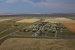
Antelope is a census-designated place (CDP) in Sheridan County, Montana, United States. The population was 51 at the 2010 census.[1]
History
Named for the nearby creek, Antelope began as a tiny community along the Great Northern Railway’s Bainville to Scobey branch line in 1910. That year, John and Richard Grayson built a hardware store next to the Antelope Creek Lutheran Church. A post office, bank, lumberyard, and saloon soon followed. The community thrived during its first decade, adding general mercantiles, a butcher shop, a concrete plant, restaurants, and other businesses to serve the region’s growing homesteader population. Over the years, however, better roads to the south siphoned off business, and the “Biggest Little City in Eastern Montana” sank into decline.[2]
Centennial Celebration
Antelope celebrated 100 years as a community on July 3, 2010. They had a parade, lunch, a skit about the history of town, and a street dance, among time for people to catch up with one another and blow up games for the kids in the park. The bar was also re-opened for the celebration as a gathering place and place to get a drink.[3]
Geography
According to the United States Census Bureau, the CDP has a total area of 0.1 square miles (0.26 km2), all of it land.
Demographics
As of the census[4] of 2000, there were 43 people, 21 households, and 11 families residing in the CDP. The population density was 532.7 people per square mile (207.5/km²). There were 24 housing units at an average density of 297.3 per square mile (115.8/km²). The racial makeup of the CDP was 100.00% White.
There were 21 households out of which 23.8% had children under the age of 18 living with them, 38.1% were married couples living together, 4.8% had a female householder with no husband present, and 47.6% were non-families. 47.6% of all households were made up of individuals and 14.3% had someone living alone who was 65 years of age or older. The average household size was 2.05 and the average family size was 3.00.
In the CDP the population was spread out with 18.6% under the age of 18, 16.3% from 18 to 24, 14.0% from 25 to 44, 34.9% from 45 to 64, and 16.3% who were 65 years of age or older. The median age was 46 years. For every 100 females there were 168.8 males. For every 100 females age 18 and over, there were 169.2 males.
The median income for a household in the CDP was $16,500, and the median income for a family was $16,500. Males had a median income of $21,250 versus $15,250 for females. The per capita income for the CDP was $5,455. There were 28.6% of families and 22.4% of the population living below the poverty line, including 26.9% of under eighteens and none of those over 64.
References
- 1 2 "2010 Census Redistricting Data (Public Law 94-171) Summary File". American FactFinder. United States Census Bureau. Archived from the original on 26 July 2011. Retrieved 2 May 2011.
- ↑ Aarstad, Rich, Ellie Arguimbau, Ellen Baumler, Charlene Porsild, and Brian Shovers. Montana Place Names from Alzada to Zortman Archived October 8, 2009, at the Wayback Machine.. Montana Historical Society Press.
- ↑ Centennial homepage
- ↑ "American FactFinder". United States Census Bureau. Archived from the original on 2013-09-11. Retrieved 2008-01-31.
Municipalities and communities of Sheridan County, Montana, United States | ||
|---|---|---|
| City | 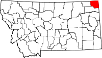 | |
| Towns | ||
| CDPs | ||
| Unincorporated communities | ||
| Ghost town | ||
| Indian reservations | ||
| Footnotes | ‡This populated place also has portions in an adjacent county or counties | |