Apalachicola, Florida
| Apalachicola, Florida | |
|---|---|
| City | |
|
A street in Apalachicola showing the Dixie Theatre | |
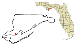 Location in Franklin County and the state of Florida | |
 Apalachicola, Florida Location in the United States | |
| Coordinates: 29°43′31″N 84°59′33″W / 29.72528°N 84.99250°WCoordinates: 29°43′31″N 84°59′33″W / 29.72528°N 84.99250°W | |
| Country | United States |
| State | Florida |
| County | Franklin |
| Government | |
| • Mayor | Van Johnson (mayor) |
| Area | |
| • Total | 2.6 sq mi (6.8 km2) |
| • Land | 1.9 sq mi (5.0 km2) |
| • Water | 0.7 sq mi (1.8 km2) |
| Elevation | 13 ft (4 m) |
| Population (2010) | |
| • Total | 2,231 |
| • Density | 1,162/sq mi (448.6/km2) |
| Time zone | Eastern (EST) (UTC-5) |
| • Summer (DST) | EDT (UTC-4) |
| ZIP codes | 32320, 32329 |
| Area code(s) | 850 |
| FIPS code | 12-01625[1] |
| GNIS feature ID | 0277920[2] |
| Website |
www |

Apalachicola is a city in Franklin County, Florida, United States, on the shore of Apalachicola Bay, an inlet of the Gulf of Mexico. The population was 2,231 at the 2010 census.[3] Apalachicola is the county seat of Franklin County.[4]
Name
"Apalachicola" comes from the Apalachicola tribe and is a combination of the Hitchiti words apalahchi, meaning "on the other side", and okli, meaning "people". In original reference to the settlement and the subgroup within the Seminole tribe, it probably meant "people on the other side of the river".[5][6] Many inhabitants of Apalachicola have said their name means "land of the friendly people".[7]
History


A British trading post called "Cottonton" was founded at this site on the mouth of the Apalachicola River. Gradually after acquisition by the United States and related development in Alabama and Georgia, it attracted more permanent European-American residents. In 1827, the town was incorporated as "West Point". Apalachicola received its current name in 1831, by an act of the Legislative Council of the Territory of Florida.
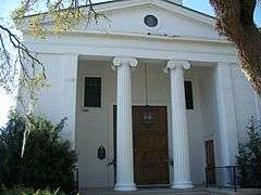
Trinity Episcopal Church was incorporated by an act of the Legislative Council of the Territory of Florida on February 11, 1837. The building was one of the earliest prefabricated buildings in the United States. The framework was shipped by schooner from New York City and assembled in Apalachicola with wooden pegs.
Botanist Alvan Wentworth Chapman (1809–1899) settled in Apalachicola in 1847. In 1860, he published his major work, Flora of the Southern United States. The former (now closed) elementary school is named in his honor.
In 1849, Apalachicola physician Dr. John Gorrie (1802–1855) discovered the cold-air process of refrigeration and patented an ice machine in 1850. He had experimented to find ways to lower the high temperatures of fever patients. His patent laid the groundwork for development of modern refrigeration and air conditioning, making Florida and the South more livable year round. The city has a monument to him, and a replica of his ice machine is on display in the John Gorrie Museum. The John Gorrie Memorial Bridge, originally built in 1935 and rebuilt in 1988, carries U.S. 98 across Apalachicola Bay to Eastpoint.
Before the development of railways in the Gulf states, Apalachicola was the third busiest port on the Gulf of Mexico (behind New Orleans and Mobile). The AN Railway, formerly the Apalachicola Northern Railroad, serves the city. In the late 19th century and early 20th century, the sponge trade, led by Greek immigrants, was a major industry in town.
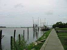
Apalachicola is still the home port for a variety of seafood workers, including oyster harvesters and shrimpers. More than 90% of Florida's oyster production is harvested from Apalachicola Bay. Every year the town hosts the Florida Seafood Festival. The bay is well protected by St. Vincent Island, Flag Island, Sand Island, St. George Island, and Cape St. George Island.
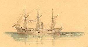
On April 3, 1862, during the American Civil War, the gunboat USS Sagamore and 186-foot (57 m) steamer USS Mercedita (relieving the USS Marion) captured Apalachicola.[8] Union forces occupied west Florida during much of the war.
In 1979, Exxon relocated their experimental subsea production system from offshore Louisiana to a permitted artificial reef site off Apalachicola. This was the first effort to turn an oil platform into an artificial reef.[9]
Apalachicola is home to the Dixie Theatre,[10] a professional Equity theater which is both a producing and presenting live performance venue. It is considered the artistic center of Franklin County. Originally built in 1912, the theatre was fully renovated beginning in 1996. It reopened in 1998.
Geography
Topography
Apalachicola is located in the northwest part of the state, at 29°43′31″N 84°59′33″W / 29.725203°N 84.992534°W,[11] on Apalachicola Bay and at the mouth of the Apalachicola River. U.S. Route 98 is the main highway through town, leading east across the bay to Eastpoint and northwest 59 miles (95 km) to Panama City. Tallahassee, the state capital, is 75 miles (121 km) to the northeast via US 98 and US 319.
According to the United States Census Bureau, the city has a total area of 2.6 square miles (6.8 km2), of which 1.9 square miles (5.0 km2) is land and 0.69 square miles (1.8 km2), or 26.67%, is water.[3]
Climate
The climate of Apalachicola is humid subtropical (Köppen Cfa), with short, mild winters and hot, humid summers. The hottest temperature ever recorded in the city was 103 °F (39 °C) on August 15, 1995,[12] and the coldest temperature ever recorded was 9 °F (−13 °C) on January 21, 1985.[12]
| Climate data for Apalachicola, Florida (Apalachicola Regional Airport), 1981–2010 normals | |||||||||||||
|---|---|---|---|---|---|---|---|---|---|---|---|---|---|
| Month | Jan | Feb | Mar | Apr | May | Jun | Jul | Aug | Sep | Oct | Nov | Dec | Year |
| Record high °F (°C) | 80 (27) |
80 (27) |
85 (29) |
90 (32) |
98 (37) |
100 (38) |
102 (39) |
103 (39) |
97 (36) |
93 (34) |
87 (31) |
83 (28) |
103 (39) |
| Average high °F (°C) | 63.1 (17.3) |
66.1 (18.9) |
70.7 (21.5) |
76.6 (24.8) |
84.2 (29) |
88.9 (31.6) |
90.6 (32.6) |
89.8 (32.1) |
87.6 (30.9) |
80.8 (27.1) |
73.1 (22.8) |
65.4 (18.6) |
78.1 (25.6) |
| Average low °F (°C) | 41.6 (5.3) |
44.6 (7) |
50.0 (10) |
56.3 (13.5) |
64.5 (18.1) |
71.5 (21.9) |
73.6 (23.1) |
73.6 (23.1) |
70.4 (21.3) |
60.5 (15.8) |
51.0 (10.6) |
44.8 (7.1) |
58.5 (14.7) |
| Record low °F (°C) | 9 (−13) |
19 (−7) |
22 (−6) |
36 (2) |
47 (8) |
48 (9) |
63 (17) |
62 (17) |
50 (10) |
33 (1) |
24 (−4) |
13 (−11) |
9 (−13) |
| Average precipitation inches (mm) | 4.40 (111.8) |
4.15 (105.4) |
5.26 (133.6) |
3.07 (78) |
2.50 (63.5) |
5.27 (133.9) |
7.07 (179.6) |
8.22 (208.8) |
6.73 (170.9) |
4.20 (106.7) |
3.53 (89.7) |
3.31 (84.1) |
57.7 (1,466) |
| Average precipitation days (≥ 0.01 in) | 7.1 | 5.9 | 6.7 | 4.1 | 3.1 | 8.9 | 10.2 | 11.3 | 8.7 | 4.1 | 3.9 | 6.1 | 80.1 |
| Mean monthly sunshine hours | 187.7 | 188.1 | 250.8 | 296.8 | 327.9 | 304.8 | 278.6 | 262.6 | 251.8 | 261.2 | 212.8 | 187.8 | 3,010.9 |
| Source: NOAA (extremes 1931–present),[13] Daily Normal and Record Temperatures in Apalachicola[12] (sun 1961–1990)[14] | |||||||||||||
Demographics
| Historical population | |||
|---|---|---|---|
| Census | Pop. | %± | |
| 1860 | 1,904 | — | |
| 1870 | 1,129 | −40.7% | |
| 1880 | 1,336 | 18.3% | |
| 1890 | 2,727 | 104.1% | |
| 1900 | 3,077 | 12.8% | |
| 1910 | 3,065 | −0.4% | |
| 1920 | 3,066 | 0.0% | |
| 1930 | 3,150 | 2.7% | |
| 1940 | 3,268 | 3.7% | |
| 1950 | 3,222 | −1.4% | |
| 1960 | 3,099 | −3.8% | |
| 1970 | 3,102 | 0.1% | |
| 1980 | 2,565 | −17.3% | |
| 1990 | 2,602 | 1.4% | |
| 2000 | 2,334 | −10.3% | |
| 2010 | 2,231 | −4.4% | |
| Est. 2015 | 2,281 | [15] | 2.2% |
As of the census[1] of 2000, there were 2,334 people, 1,006 households, and 608 families residing in the city. The population density was 1,242.1 inhabitants per square mile (479.3/km²). There were 1,207 housing units at an average density of 642.3 per square mile (247.9/km²). The racial makeup of the city was 63.41% White, 34.92% African American, 0.17% Native American, 0.39% Asian, 0.47% from other races, and 0.64% from two or more races. Hispanic or Latino of any race were 1.67% of the population.
There were 1,006 households out of which 23.4% had children under the age of 18 living with them, 41.8% were married couples living together, 15.0% had a female householder with no husband present, and 39.5% were non-families. Of all households, 34.7% were made up of individuals and 14.8% had someone living alone who was 65 years of age or older. The average household size was 2.24 and the average family size was 2.87.
In the city the population was spread out with 21.9% under the age of 18, 7.0% from 18 to 24, 24.0% from 25 to 44, 26.7% from 45 to 64, and 20.5% who were 65 years of age or older. The median age was 43 years. For every 100 females there were 90.2 males. For every 100 females age 18 and over, there were 86.3 males.
The median income for a household in the city was $23,073, and the median income for a family was $28,464. Males had a median income of $22,500 versus $18,750 for females. The per capita income for the city was $12,227. About 19.9% of families and 25.3% of the population were below the poverty line, including 32.4% of those under age 18 and 15.0% of those age 65 or over.
Travel
Travel to Apalachicola continues to increase as tourists seek experiences of "Old Florida", as many describe the feel of smaller coastal communities in the state. Southern Living published a feature article "Florida's Quiet Side" in February 2007. Wanda McKinney writes:
Morning comes gently to Apalachicola. Oyster boats and shrimpboats begin their daily pilgrimages into the seafood-rich bay as the sun rises on the Northwest Florida coast. The lights twinkle on in this fishing village, its residents ready for another day in unspoiled paradise. If you ever wondered if such a place still exists, yes, old Florida lives here. A lone blinking yellow light directs the downtown traffic. Come and stay awhile in this wonderful, walkable, watery hamlet. Try the pace on for size.[17]
Education
Apalachicola is a part of the Franklin County Schools system.[18] As of the 2008–2009 school year, all students, except those attending charter schools, attend the K–12 Franklin County School. Apalachicola Bay Charter School is also located in Apalachicola.
Apalachicola in popular culture
- In the 1947 Bob Hope, Bing Crosby film, Road to Rio, Hope sings ("We're on Our Way to...) Apalachicola, F-L-A," which was written by Crosby.
- Apalachicola is mentioned in the Jack Kerouac song "Home I'll Never Be", as performed by Tom Waits; in the 2006 Tom T. Hall song "Redneck Riviera"; and in the 2009 Tim McGraw song "Southern Voice".
References
- 1 2 "American FactFinder". United States Census Bureau. Archived from the original on 2013-09-11. Retrieved 2008-01-31.
- ↑ "US Board on Geographic Names". United States Geological Survey. 2007-10-25. Retrieved 2008-01-31.
- 1 2 "Geographic Identifiers: 2010 Census Summary File 1 (G001), Apalachicola city, Florida". American FactFinder. U.S. Census Bureau. Retrieved April 26, 2016.
- ↑ "Find a County". National Association of Counties. Archived from the original on 2011-05-31. Retrieved 2011-06-07.
- ↑ "Apalachicola" Archived May 2, 2006, at the Wayback Machine., Florida Heritage Facts, Dept. of Historic Resources
- ↑ Florida Department of State
- ↑ Bay Navigator, Brief History Archived October 25, 2006, at the Wayback Machine.
- ↑ USS Mercedita history
- ↑ Dauterive, Les (2000). "Rigs-to-Reefs policy, progress, and perspective.". In: Hallock and French (eds). Diving for Science...2000. Proceedings of the 20th Annual Scientific Diving Symposium. American Academy of Underwater Sciences. Retrieved 2011-01-07.
- ↑
- ↑ "US Gazetteer files: 2010, 2000, and 1990". United States Census Bureau. 2011-02-12. Retrieved 2011-04-23.
- 1 2 3 "Daily Normal and Record Temperatures in Apalachicola". National Oceanic and Atmospheric Administration. Retrieved 2013-11-20.
- ↑ "NowData - NOAA Online Weather Data". National Oceanic and Atmospheric Administration. Retrieved 2016-05-31.
- ↑ "WMO Climate Normals for Apalachicola, Florida 1961–1990". National Oceanic and Atmospheric Administration. Retrieved February 3, 2014.
- ↑ "Annual Estimates of the Resident Population for Incorporated Places: April 1, 2010 to July 1, 2015". Retrieved July 2, 2016.
- ↑ "Census of Population and Housing". Census.gov. Archived from the original on May 11, 2015. Retrieved June 4, 2015.
- ↑ "Florida's Quiet Side" Archived November 14, 2008, at the Wayback Machine.
- ↑ Franklin County Schools website Archived April 24, 2006, at the Wayback Machine.
Sources
-
 This article incorporates text from a publication now in the public domain: Chisholm, Hugh, ed. (1911). "Apalachicola". Encyclopædia Britannica (11th ed.). Cambridge University Press.
External links
| Wikimedia Commons has media related to Apalachicola, Florida. |
-
 Apalachicola travel guide from Wikivoyage
 - City of Apalachicola official website
- Apalachicola Bay Chamber of Commerce
Municipalities and communities of Franklin County, Florida, United States | ||
|---|---|---|
| Cities |  | |
| CDPs | ||
| Unincorporated communities | ||