Apucarana
| Apucarana | |||
|---|---|---|---|
 | |||
| |||
 | |||
 Apucarana Location in Brazil | |||
| Coordinates: BR 23°33′03″S 51°27′39″W / 23.55083°S 51.46083°W | |||
| Country |
| ||
| Region | South | ||
| State |
| ||
| Founded | 1944 | ||
| Area | |||
| • Total | 548 km2 (212 sq mi) | ||
| Elevation | 840 m (2,760 ft) | ||
| Population (2012) | |||
| • Total | 118,107 | ||
| • Density | 220/km2 (560/sq mi) | ||
| Demonym(s) | Apucaranense | ||
| Time zone | UTC-3 (UTC-3) | ||
| Postal code | 86800 | ||
| Area code(s) | (+55) 43 | ||
| Website | Official website (Portuguese) | ||

Apucarana is a municipality in the state of Paraná in Brazil. The municipality covers 548 square kilometres (212 sq mi) at an elevation of 840 metres (2,760 ft) above mean sea level. Its 2008 population was estimated as 120,133.[1]
Transportation
The city is served by Cap. João Busse Airport[2] which is located 10 kilometers (5 nautical miles) southeast of Apucarana.[3]
Economy
In agriculture, the city stands in production of coffee, soy, beans and corn. The industry stands out for leather production (3% of Brazil's total) and the manufacturing of caps (80% of production in Brazil).
Culture
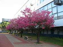
The city received thousands of immigrants from Portugal, Ukraine, Poland, Germany and especially from Japan (who did strong influence in culture like in the Buddhist religion and the amount of cherry trees planted - the city has more than 20,000 sakuras and annually do the "Cherry Festival" to celebrate the Japanese culture[4]).
| Races | |
|---|---|
| White | 71,95% |
| Brown | 17,84% |
| Black | 5,97% |
| Asian | 3,77% |
| Natives | 0,47% |
source : PARDES 2010
Religion
The city is the seat of the Roman Catholic Diocese of Apucarana.
Congregação Cristã no Brasil
References
- ↑ "Estimativas da população para 1º de julho de 2008 (Estimates of the population for July 1, 2008)" (PDF). Instituto Brasileiro de Geografia e Estatística (Brazilian Institute of Geography and Statistics). 2008-08-29.
- ↑ Apucarana - SSAP (Cap. João Busse) Archived July 6, 2011, at the Wayback Machine. at official Paraná website. Retrieved 2008-09-18.
- ↑ Distance & heading from Apucarana to airport (SSAP) as calculated by Great Circle Mapper. Retrieved 2008-09-18.
- 1 2 "Cerejeiras enfeitam cidade no norte do Paraná" (in Portuguese). Jornal Nacional. Retrieved 2011-07-15.
External links
- Prefeitura Municipal de Apucarana (City of Apucarana)
- Informações sobre a Cidade (Business and Information from Apucarana)