Aquinnah, Massachusetts
| Aquinnah, Massachusetts | ||
|---|---|---|
| Town | ||
|
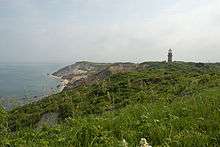
The Gay Head cliffs of clay, located on the western-most part of the island. | ||
| ||
 Location in Dukes County in Massachusetts | ||
| Coordinates: 41°20′4″N 70°47′45″W / 41.33444°N 70.79583°WCoordinates: 41°20′4″N 70°47′45″W / 41.33444°N 70.79583°W | ||
| Country |
| |
| State |
| |
| County | Dukes | |
| Settled | 1669 | |
| Incorporated | 1870 | |
| Government | ||
| • Type | Open town meeting | |
| Area | ||
| • Total | 105.6 km2 (40.8 sq mi) | |
| • Land | 13.9 km2 (5.4 sq mi) | |
| • Water | 91.7 km2 (35.4 sq mi) | |
| Elevation | 30 m (98 ft) | |
| Population (2010) | ||
| • Total | 311 | |
| • Density | 22.4/km2 (57.6/sq mi) | |
| Time zone | Eastern (UTC-5) | |
| • Summer (DST) | Eastern (UTC-4) | |
| ZIP code | 02535 | |
| Area code(s) | 508 / 774 | |
| FIPS code | 25-01585 | |
| GNIS feature ID | 0618289 | |
| Website | http://www.aquinnah-ma.gov | |


Aquinnah is a town located on the island of Martha's Vineyard in Massachusetts. The population was 311 at the 2010 U.S. census. It is known for its beautiful clay cliffs and quiet natural serenity. Below the clay cliffs is Jungle Beach, named to reflect its reputation as one of the few nude beaches left in the U.S.
Aquinnah has become celebrated as a center of Wampanoag culture and a center of pride and tradition among members of the federally recognized Wampanoag Tribe of Gay Head. They make up about one-third of the town's voters and are one of two federally recognized tribes of Wampanoag in Massachusetts. This area is one of the earliest sites of whaling. The Wampanoag harvested whales from small boats and shore, using harpoons, long before the 19th-century industry of whaling became the major maritime industry of Martha's Vineyard, Nantucket, and New Bedford, Massachusetts.
History
Before the arrival of English colonists, Martha's Vineyard and Aquinnah were inhabited by the Wampanoag, a Native American people, related to the larger Algonquin Nation of Southern New England. The Wampanoag have a separate history; their creation myth has them arriving on an ice floe from the far North. They sided with the English settlers in King Philip's War. They performed whaling from small boats.[1] The character Tashtego in Herman Melville's novel Moby-Dick is a harpooner from Aquinnah.[2]
First settled by English colonists in 1669, the town of Aquinnah was officially separated by them from Chilmark and incorporated in 1870 as Gay Head, Massachusetts. Gay Head was a descriptive name referring to the brilliant colors of the cliffs.[3] It has frequently been noted on lists of unusual place names.[4]
In 1997, by popular vote of 79 to 21, the town changed its name to Aquinnah, which is Wampanoag for "land under the hill."[5][6] Throughout its history, the town has been home to a Wampanoag community. It gained federal recognition in 1987 and controls tribal lands in the town.

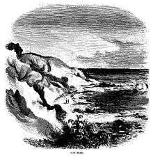
The most outstanding feature this small town has is its brightly colored clay cliffs. The clay cliffs are ecologically protected, and it is forbidden to climb the cliffs or touch the clay.
Moshup's Beach
The beach below the cliffs is called Moshup's Beach, named after a giant sachem who used to lead the tribe and of whom many myths are told. The ocean is a rare aqua color here with waves heights that are above average for the area. The water sometimes has a reddish tinge resulting from the above cliffs. Throughout the 1960s and 1970s, the beach was a haven for nude sunbathers who delighted in "clay baths", though this is now not allowed. Although not officially designated a "nude beach", the area just before and just after the first point remains "clothing optional".
The protection of the clay cliffs is strictly enforced. A uniformed police officer frequently patrols the beach on ATV, handing out $50 fines for tampering with the clay or engaging in any other illegal activities. Under Massachusetts General Law Ch 272 Sec 59, one may also be arrested for disturbing the clay. The cliffs are also patrolled often by a member of the Wampanoag tribe, who informs people about the importance of the cliffs to the tribe, and how they feature prominently in their spirituality and myths.
Geography
According to the United States Census Bureau, the town has a total area of 40.8 square miles (106 km2), of which 5.4 square miles (14 km2) is land and 35.4 square miles (92 km2) (86.85%) is water. Aquinnah ranks 334th in area out of 351 communities in the Commonwealth, and is the smallest town by land area on the Vineyard. Aquinnah is bordered by Vineyard Sound to the north and northwest, Chilmark to the east, and the Atlantic Ocean to the south and west.
Aquinnah is separated from the town of Chilmark by Menemsha Bight, Menemsha Pond, and Squibnocket Pond. The only road into town lies between the ponds. (Squibnocket Beach, which lies between the ocean and Squibnocket Pond, also connects to the town, but is often washed out during storms. No road crosses it.) Squibnocket Point, just east of this beach, is the southernmost point on Martha's Vineyard. Aquinnah has four beaches: Philbin Beach (resident parking only; however, the beach is open to the public) and Moshup Beach to the southwest, Long Beach (adjacent to Squibnocket Beach but privately owned), and Lobsterville Beach along the Sound side of town. The Gay Head Cliffs are in a protected area at the western end of town where the Gay Head Lighthouse stands.
There is no direct transit between Aquinnah and the mainland. Many visitors use planes at Martha's Vineyard Airport, located in nearby West Tisbury. Others travel by car and ferry; the Woods Hole Ferry is in Vineyard Haven, approximately seventeen miles from the town center.
Demographics
| Historical population | ||
|---|---|---|
| Year | Pop. | ±% |
| 1870 | 160 | — |
| 1880 | 101 | −36.9% |
| 1890 | 139 | +37.6% |
| 1900 | 173 | +24.5% |
| 1910 | 162 | −6.4% |
| 1920 | 144 | −11.1% |
| 1930 | 161 | +11.8% |
| 1940 | 127 | −21.1% |
| 1950 | 88 | −30.7% |
| 1960 | 103 | +17.0% |
| 1970 | 118 | +14.6% |
| 1980 | 220 | +86.4% |
| 1990 | 201 | −8.6% |
| 2000 | 344 | +71.1% |
| 2010 | 311 | −9.6% |
| * = population estimate. Source: United States Census records and Population Estimates Program data.[7][8][9][10][11][12][13][14] | ||
As of the census[15] of 2000, there were 344 people, 141 households, and 88 families residing in the town. The population density was 64.1 people per square mile (24.8/km²). There were 463 housing units at an average density of 86.3 per square mile (33.4/km²). The racial makeup of the town was 53.49% White, 0.29% African American, 36.63% Native American, 0.87% from other races, and 8.72% from two or more races. Hispanic or Latino of any race were 1.16% of the population.
There were 141 households out of which 33.3% had children under the age of 18 living with them, 38.3% were married couples living together, 17.7% had a female householder with no husband present, and 36.9% were non-families. 30.5% of all households were made up of individuals and 7.8% had someone living alone who was 65 years of age or older. The average household size was 2.44 and the average family size was 3.04.
In the town the population was spread out with 25.3% under the age of 18, 8.7% from 18 to 24, 31.7% from 25 to 44, 24.1% from 45 to 64, and 10.2% who were 65 years of age or older. The median age was 37 years. For every 100 females there were 96.6 males. For every 100 females age 18 and over, there were 84.9 males.
The median income for a household in the town was $45,208, and the median income for a family was $46,458. Males had a median income of $37,917 versus $26,250 for females. The per capita income for the town was $21,420. About 8.6% of families and 7.1% of the population were below the poverty line, including 4.0% of those under age 18 and 14.3% of those age 65 or over.
Government
On the national level, Aquinnah is a part of Massachusetts's 9th congressional district, and is represented by William Keating. The state's senior member of the United States Senate is Elizabeth Warren, following John Kerry's nomination as United States Secretary of State. The junior Senator is Ed Markey.
On the state level, Aquinnah is represented in the Massachusetts House of Representatives as a part of the Barnstable, Dukes and Nantucket district, which includes all of Martha's Vineyard and Nantucket, as well as a portion of Falmouth. The town is represented in the Massachusetts Senate as a portion of the Cape and Islands district, which includes all of Martha's Vineyard, Nantucket and most of Barnstable County (with the exception of Bourne, Sandwich, Falmouth and a portion of Barnstable.[16] All of Dukes County is patrolled by the Fifth (Oak Bluffs) Barracks of Troop D of the Massachusetts State Police.[17]
Aquinnah is governed on the local level by the open town meeting form of government, and is led by an executive secretary and a board of selectmen. The town has its own police and fire departments, near the Town Hall at the town center. The Aquinnah Public Library, a one-room library of less than 1,000 square feet (93 m2), is also nearby. The post office is located 8 miles (13 km) away in Chilmark.
Education
Aquinnah is served by Martha's Vineyard Public Schools. Chilmark Elementary School and Up-Island Regional School in West Tisbury, serve the town's elementary and middle–school students. Martha's Vineyard Regional High School, located in Oak Bluffs, serves the entire island's high–school population. MVRHS's teams are nicknamed the Vineyarders, and their colors are purple and white. The school has a longstanding rivalry with Nantucket High School, and the annual Island Cup between the football teams attracts a strong following.
See also
References
- ↑ "Aquinnah (previously known as Gay Head)", Massachusetts Department of Housing and Community Development. Retrieved: 14 August 2012.
- ↑ Melville, H., "Moby-Dick", chapter 27. The Folio Society 2009. A Limited Edition with 281 illustrations by Rockwell Kent.
- ↑ Gannett, Henry (1905). The Origin of Certain Place Names in the United States. Govt. Print. Off. p. 135.
- ↑ Parker, Quentin (2010). Welcome to Horneytown, North Carolina, Population: 15: An insider's guide to 201 of the world's weirdest and wildest places. Adams Media.
- ↑ Boston Globe, May 15, 1997
- ↑ "Wampanoag" Cradleboard Teaching Project. Retrieved: 14 August 2012.
- ↑ "TOTAL POPULATION (P1), 2010 Census Summary File 1, All County Subdivisions within Massachusetts". United States Census Bureau. Retrieved September 13, 2011.
- ↑ "Massachusetts by Place and County Subdivision - GCT-T1. Population Estimates". United States Census Bureau. Archived from the original on January 6, 2012. Retrieved July 12, 2011.
- ↑ "1990 Census of Population, General Population Characteristics: Massachusetts" (PDF). US Census Bureau. December 1990. Table 76: General Characteristics of Persons, Households, and Families: 1990. 1990 CP-1-23. Retrieved July 12, 2011.
- ↑ "1980 Census of the Population, Number of Inhabitants: Massachusetts" (PDF). US Census Bureau. December 1981. Table 4. Populations of County Subdivisions: 1960 to 1980. PC80-1-A23. Archived from the original on August 5, 2010. Retrieved July 12, 2011.
- ↑ "1950 Census of Population" (PDF). 1: Number of Inhabitants. Bureau of the Census. 1952. Section 6, Pages 21-10 and 21-11, Massachusetts Table 6. Population of Counties by Minor Civil Divisions: 1930 to 1950. Retrieved July 12, 2011.
- ↑ "1920 Census of Population" (PDF). Bureau of the Census. Number of Inhabitants, by Counties and Minor Civil Divisions. Pages 21-5 through 21-7. Massachusetts Table 2. Population of Counties by Minor Civil Divisions: 1920, 1910, and 1920. Retrieved July 12, 2011.
- ↑ "1890 Census of the Population" (PDF). Department of the Interior, Census Office. Pages 179 through 182. Massachusetts Table 5. Population of States and Territories by Minor Civil Divisions: 1880 and 1890. Retrieved July 12, 2011.
- ↑ "1870 Census of the Population" (PDF). Department of the Interior, Census Office. 1872. Pages 217 through 220. Table IX. Population of Minor Civil Divisions, &c. Massachusetts. Archived from the original on August 8, 2010. Retrieved July 12, 2011.
- ↑ "American FactFinder". United States Census Bureau. Archived from the original on 2013-09-11. Retrieved 2008-01-31.
- ↑ Index of Legislative Representatives by City and Town
- ↑ Station D-5, SP Oak Bluffs
External links
| Wikivoyage has a travel guide for Aquinnah. |
| Wikimedia Commons has media related to Aquinnah, Massachusetts. |
- Official town website
- History and Culture Wampanoag Official Webpage
- Aquinnah Music Festival
- Souvenir of Gay Head (Collection of photographs from the 1880s)
Municipalities and communities of Dukes County, Massachusetts, United States | ||
|---|---|---|
| Towns |  | |
| CDPs | ||
| Other villages | ||