Aracruz, Espírito Santo
| Aracruz Município de Aracruz | |||
|---|---|---|---|
| Municipality | |||
|
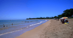
Putiri Beach, Aracruz, Espírito Santo | |||
| |||
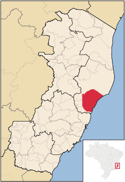 Location of Aracruz in Espírito Santo | |||
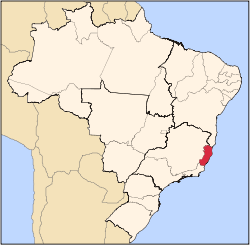
 Aracruz Location of Aracruz in Brazil | |||
| Coordinates: 19°49′12″S 40°16′22″W / 19.82000°S 40.27278°WCoordinates: 19°49′12″S 40°16′22″W / 19.82000°S 40.27278°W | |||
| Country | Brazil | ||
| Region | Southeast | ||
|
| |||
| Founded | April 3, 1848 | ||
| Government | |||
| • Mayor | Marcelo de Souza Coelho (PDT, 2013–2016) | ||
| Area | |||
| • Total | 1,423.87 km2 (549.76 sq mi) | ||
| Population (2014) | |||
| • Total | 93,325 | ||
| • Density | 66/km2 (170/sq mi) | ||
| Demonym(s) | Aracruzense | ||
| Time zone | BRT (UTC-3) | ||
| Website |
pma | ||

Aracruz is a municipality at the central coast of Espírito Santo, Brazil.
Location
Aracruz covers 1,423.87 km2 (549.76 sq mi), and has a population of 93,325 with a population density of 66 inhabitants per square kilometer.[1] The municipality contains part of the 785 hectares (1,940 acres) Comboios Biological Reserve, a fully protected area.[2] The 17,741 hectares (43,840 acres) Santa Cruz Wildlife Refuge created in 2010 extends offshore from the municipality.[3] The coastline of the municipality is also protected in part by the 112,545 hectares (278,100 acres) Costa das Algas Environmental Protection Area, created in 2010.[4]
History
The municipality's history begins in 1556, when two Jesuit priests (Braz Lourenço and Diogo Jácomo) founded Santa Cruz, a town then called Aldeia Nova (New Village). Aldeia Nova later became known as Aldeia Velha (Old Village), since it didn't prosper as much as its neighbour, which then became known as Aldeia Nova, and is today called Nova Almeida. Aldeia Velha became emancipated as a municipality in 1848, and changed its name to Santa Cruz. In 1943, the municipality and its capital were both renamed Aracruz. However, the biggest economic driver at the time was jacarandá wood, and Sauaçu held most of the wood processing plants (serrarias), so in 1948 the capital was moved to Sauaçu (also called Sauassu), and the capital's name went with it. Sauaçu then became known as Aracruz, and Aracruz reverted to its formal and present name, Santa Cruz.
Santa Cruz was founded at the mouth of the Piraquê-mirim and Piraquê-açu Rivers, as were a number of Amerindian tribes. After a visit from the Emperor Peter II who slept in Santa Cruz in 1860, he signed permission for 386 Italian families to settle in Santa Cruz, and those families founded Fazenda Nova Trento (New Trento Farm) around 1874. Other groups moved up the Piraquê-açu river to found Palmas Farm (Fazenda das Palmas) and Santa Teresa. At this time coffee and cassava plantations were common.
Another large wave of Italian immigrants began coming around 1872, when a ship called Sofia arrived bringing 386 Italians from the region of Trento. Those went on to found Nova Trento Colony.
Population
Today Aracruz is home to roughly 1500 Amerindians divided into six reservations: Caieiras Velha, Comboios, Irajá, Pau Brasil, Tekoá and Três Palmeiras. Only in the last couple of decades have they been able to secure their land here, as many problems with local paper industry greatly prolonged their land struggles. Those Indians are of two tribes: the Tupiniquim and the Guarani. The Indians in Aracruz Municipality no longer speak their native languages, but they hold on to their traditional subsistence farming and handcraft trade.
References
| Wikivoyage has a travel guide for Aracruz. |
- ↑ "Aracruz" (in Portuguese). Brasília, Brazil: Instituto Brasileiro de Geografia e Estatstica. 2015. Retrieved 2015-09-02.
- ↑ Unidade de Conservação: Reserva Biológica de Comboios (in Portuguese), MMA: Ministério do Meio Ambiente, retrieved 2016-04-25
- ↑ RVS Santa Cruz (in Portuguese), ISA: Instituto Socioambiental, retrieved 2016-10-23
- ↑ APA Costa das Algas (in Portuguese), ISA: Instituto Socioambiental, retrieved 2016-10-28
Capital: Vitória | ||||||||||||||||
| Mesoregion Central |
|  | ||||||||||||||
| Mesoregion Litoral Norte |
| |||||||||||||||
| Mesoregion Noroeste |
| |||||||||||||||
| Mesoregion Sul |
| |||||||||||||||