Arcadia Lakes, South Carolina
| Arcadia Lakes, South Carolina | |
|---|---|
| Town | |
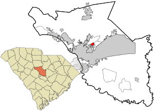 Location in Richland County and the state of South Carolina. | |
| Coordinates: 34°3′1″N 80°57′51″W / 34.05028°N 80.96417°WCoordinates: 34°3′1″N 80°57′51″W / 34.05028°N 80.96417°W | |
| Country | United States |
| State | South Carolina |
| County | Richland |
| Area | |
| • Total | 0.7 sq mi (1.7 km2) |
| • Land | 0.5 sq mi (1.4 km2) |
| • Water | 0.1 sq mi (0.3 km2) |
| Elevation | 226 ft (69 m) |
| Population (2010) | |
| • Total | 861 |
| • Density | 1,300/sq mi (510/km2) |
| Time zone | EST (UTC-5) |
| • Summer (DST) | EDT (UTC-4) |
| ZIP code | 29206 |
| Area code(s) | 803 |
| FIPS code | 45-02125[1] |
| GNIS feature ID | 1231010[2] |
| Website |
arcadialakes |
Arcadia Lakes is a small town in Richland County, South Carolina, United States. The population was 861 at the 2010 census.[3] It is part of the Columbia, South Carolina, Metropolitan Statistical Area.
Arcadia Lakes shares a ZIP code with part of northeastern Columbia, and all locations in the town have Columbia mailing addresses.
Geography
Arcadia Lakes is located at 34°3′1″N 80°57′51″W / 34.05028°N 80.96417°W (34.050223, -80.964113).[4]
According to the United States Census Bureau, the town has a total area of 0.66 square miles (1.7 km2), of which 0.54 square miles (1.4 km2) is land and 0.12 square miles (0.3 km2), or 18.40%, is water.[3]
Demographics
| Historical population | |||
|---|---|---|---|
| Census | Pop. | %± | |
| 1960 | 316 | — | |
| 1970 | 741 | 134.5% | |
| 1980 | 611 | −17.5% | |
| 1990 | 899 | 47.1% | |
| 2000 | 882 | −1.9% | |
| 2010 | 861 | −2.4% | |
| Est. 2015 | 869 | [5] | 0.9% |
| U.S. Decennial Census | |||
As of the census[1] of 2000, there were 882 people, 379 households, and 278 families residing in the town. The population density was 1,685.6 people per square mile (654.9/km²). There were 389 housing units at an average density of 743.4 per square mile (288.8/km²). The racial makeup of the town was 94.90% White, 3.63% African American, 0.79% Asian, 0.23% from other races, and 0.45% from two or more races. Hispanic or Latino of any race were 0.79% of the population.
There were 379 households out of which 24.8% had children under the age of 18 living with them, 66.8% were married couples living together, 4.7% had a female householder with no husband present, and 26.6% were non-families. 22.7% of all households were made up of individuals and 10.8% had someone living alone who was 65 years of age or older. The average household size was 2.33 and the average family size was 2.72.
In the town the population was spread out with 20.2% under the age of 18, 3.1% from 18 to 24, 18.5% from 25 to 44, 34.6% from 45 to 64, and 23.7% who were 65 years of age or older. The median age was 49 years. For every 100 females there were 97.3 males. For every 100 females age 18 and over, there were 89.2 males.
The median income for a household in the town was $66,382, and the median income for a family was $79,179. Males had a median income of $56,125 versus $35,682 for females. The per capita income for the town was $37,762. About 0.7% of families and 2.9% of the population were below the poverty line, including 2.1% of those under age 18 and none of those age 65 or over.
References
- 1 2 "American FactFinder". United States Census Bureau. Archived from the original on 2013-09-11. Retrieved 2008-01-31.
- ↑ "US Board on Geographic Names". United States Geological Survey. 2007-10-25. Retrieved 2008-01-31.
- 1 2 "Geographic Identifiers: 2010 Demographic Profile Data (G001): Arcadia Lakes town, South Carolina". U.S. Census Bureau, American Factfinder. Retrieved January 14, 2013.
- ↑ "US Gazetteer files: 2010, 2000, and 1990". United States Census Bureau. 2011-02-12. Retrieved 2011-04-23.
- ↑ "Annual Estimates of the Resident Population for Incorporated Places: April 1, 2010 to July 1, 2015". Retrieved July 2, 2016.
External links
Municipalities and communities of Richland County, South Carolina, United States | ||
|---|---|---|
| Cities | 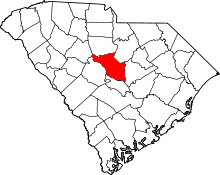 | |
| Towns | ||
| CDPs | ||
| Unincorporated communities | ||
| Footnotes | ‡This populated place also has portions in an adjacent county or counties | |