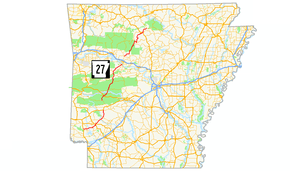
Arkansas Highway 27
| ||||
|---|---|---|---|---|
 | ||||
| Route information | ||||
| Maintained by AHTD | ||||
| Length: | 193.14 mi[1] (310.83 km) | |||
| Major junctions | ||||
| South end: |
| |||
|
| ||||
| North end: |
| |||
| Highway system | ||||
| ||||

Arkansas Highway 27 (AR 27, Hwy. 27) is a north–south state highway in Arkansas. The route of 193.14 miles (310.83 km) runs from U.S. Route 59/US Route 71 (US 59/US 71) near Ben Lomond north to Highway 14 at Harriet.[2]
Route description
AR 27 begins at US 59/US 71 near Ben Lomond. The route runs east, meeting AR 317 before meeting AR 355 in Mineral Springs. The route continues to Nashville where it meets US 278 and US 371/AR 24. North of Nashville, AR 27 meets AR 26 until Murfreesboro, when it picks up AR 19.
The route winds north to meet US 70/AR 84 in Kirby. AR 27 follows US 70 until Glenwood, when it meets AR 8 and enters the Ouachita National Forest. The two routes run together until Norman. AR 27 continues northeast to US 270 in Mt. Ida, and then to Washita where it meets AR 298. The route eventually leaves the forest near Rover, which contains a junction with AR 28.
AR 27 meets AR 10 in Danville and continues north to Dardanelle. The route meets AR 7/AR 22/AR 247 on the south edge of town. It then crosses the Arkansas River into Russellville, where it meets US 64 in downtown, and Interstate 40 north of town. A concurrency with AR 7 ends in Dover, with AR 27 turning right at Market Street.
The route winds northward for a stretch, eventually meeting AR 16 and AR 333 in rural Searcy County. AR 27 continues northeast to meet US 65/AR 74 in Marshall. After Marshall, the route trails north to Harriet, where it terminates at AR 14.
Major intersections
| County | Location | mi | km | Destinations | Notes | |||
|---|---|---|---|---|---|---|---|---|
| Sevier | | |||||||
| Cowlingsville | ||||||||
| Howard | Mineral Springs | South end of AR 355 overlap | ||||||
| North end of AR 355 overlap | ||||||||
| Nashville | ||||||||
| Interchange; south end of US 278 overlap | ||||||||
| North end of US 278 overlap | ||||||||
| Hempstead |
No major junctions | |||||||
| Pike | | South end of AR 26 overlap | ||||||
| Murfreesboro | Junction around Pike County Courthouse | |||||||
| South end of AR 19 overlap | ||||||||
| South end of AR 19 / AR 26 overlap | ||||||||
| | ||||||||
| Kirby | South end of US 70 overlap | |||||||
| Salem | ||||||||
| Glenwood | South end of AR 8 overlap | |||||||
| North end of US 70 overlap; south end of US 70B overlap | ||||||||
| North end of US 70B overlap | ||||||||
| Montgomery | | |||||||
| Norman | North end of AR 8 overlap | |||||||
| Mount Ida | South end of US 270 overlap | |||||||
| | North end of US 270 overlap | |||||||
| | ||||||||
| Washita | ||||||||
| Story | ||||||||
| Yell | Onyx | |||||||
| Rover | South end of AR 28 overlap | |||||||
| | North end of AR 28 overlap | |||||||
| Danville | ||||||||
| South end of AR 10 overlap | ||||||||
| North end of AR 10 overlap | ||||||||
| | ||||||||
| | ||||||||
| Dardanelle | ||||||||
| Gap in route | ||||||||
| Pope | Dover | |||||||
| Scottsville | ||||||||
| | ||||||||
| | South end of AR 16 overlap | |||||||
| | North end of AR 16 overlap | |||||||
| Van Buren | Una | |||||||
| Searcy | Canaan | South end of AR 333 overlap | ||||||
| | North end of AR 333 overlap | |||||||
| Marshall | South end of US 65 overlap | |||||||
| North end of US 65 overlap | ||||||||
| Harriet | ||||||||
1.000 mi = 1.609 km; 1.000 km = 0.621 mi
| ||||||||
Bannered routes
Arkansas Highway 27 had two auxiliary routes, with AR 27N being removed in the 1990s.
Nashville business route
| |
|---|---|
| Location: | Nashville |
| Length: | 2.38 mi[1] (3.83 km) |
Arkansas Highway 27B is a business route in Nashville. It is 2.38 miles (3.83 km) in length.
Former route
| |
|---|---|
| Location: | Ben Lomond |
Arkansas Highway 27N was a short east–west highway in southwest Arkansas. Its eastern terminus was at Arkansas Highway 27 east of Ben Lomond with its western terminus at U.S. Route 71 1-mile (1.6 km) south of Falls Chapel. In the 1990s Highway 27N was replaced by a realigned Highway 27.
See also
 Arkansas portal
 U.S. Roads portal
References
- 1 2 Planning and Research Division (2010). "Arkansas Road Log Database". Arkansas State Highway and Transportation Department. Archived from the original (Database) on 23 June 2011. Retrieved June 9, 2011.
- ↑ General Highway Map, Carroll County, Arkansas (PDF) (Map). 1:62500. Cartography by Planning and Research Division. Arkansas State Highway and Transportation Department. 2010. Retrieved June 25, 2011.