Dardanelle, Arkansas
| Dardanelle, Arkansas | |
|---|---|
| City | |
|
Historic downtown Dardanelle, February 2009 | |
| Motto: "where history & hospitality reside"[1] | |
 Location in Yell County and the state of Arkansas | |
| Coordinates: 35°13′21″N 93°9′37″W / 35.22250°N 93.16028°WCoordinates: 35°13′21″N 93°9′37″W / 35.22250°N 93.16028°W | |
| Country | United States |
| State | Arkansas |
| County | Yell |
| Area | |
| • Total | 3.1 sq mi (7.9 km2) |
| • Land | 3.1 sq mi (7.9 km2) |
| • Water | 0 sq mi (0 km2) |
| Elevation | 331 ft (101 m) |
| Population (2010) | |
| • Total | 4,745 |
| • Density | 1,363.9/sq mi (535.2/km2) |
| Time zone | Central (CST) (UTC-6) |
| • Summer (DST) | CDT (UTC-5) |
| ZIP code | 72834 |
| Area code(s) | 479 |
| FIPS code | 05-17380 |
| GNIS feature ID | 0079131 |
| Website | City of Dardanelle Arkansas |

Dardanelle is a city in Yell County, Arkansas, United States. The population was 4,745 at the 2010 census. Along with Danville, it serves as a county seat for Yell County.[2] It is located near Lake Dardanelle.
Dardanelle is part of the Russellville Micropolitan Statistical Area.
History

Dardanelle is one of the oldest cities in the state of Arkansas. Officially incorporated in 1855, Dardanelle celebrated its 150th anniversary in 2005. However, the area had been settled for years before that, first being established as a river town in the mid-18th century. It is Yell County's dual county seat, sharing that title with Danville.
The Treaty of Council Oaks was signed on June 24, 1823 on what is now Front Street beneath two huge oak trees (102 feet high and 400–500 years old). Under orders of President James Monroe, U.S. Army Colonel David Brearly and Arkansas territorial secretary Robert Crittendon met with Chief Black Fox and several Cherokee leaders to determine boundaries. As a result of the treaty, the Cherokees gave up all of their land in Arkansas south of the Arkansas River. One of the trees was destroyed in the early 1990s in a flood, but the other is still standing. The site is now a city park.[4]
Because of its location on the banks of the Arkansas River, Dardanelle was one of Arkansas's leading towns in the 19th century. Hundreds of barges, steamboats, and other vessels traveled by the town annually. Approximately halfway between the state's two largest cities of Little Rock and Fort Smith, Dardanelle was a transportation and business hub, known as a marketplace for gin, rum and cotton.[5]
Dardanelle has a history of being one of the state's leading immigration centers that continues to this day. Vast numbers of Czech and German families, including the Ballouns, Vodrazkas, Staneks, and Pfeiffers, came to the town in the late 18th and early 19th centuries, and their impact can still be felt.[6] As of 2010, Dardanelle has one of the highest percentages of Hispanics in the state, with over 36% of the town's population Hispanic (up from 21% in 2000).[7]
Merritt Park opened in the late 1990s on the west side of town. It is a large, state-of-the-art park featuring outstanding baseball facilities, a playground, soccer fields, basketball courts, and a walking/jogging trail. The adjacent Dardanelle Community Center opened around the same time, and provides multiple services for the community.
In the late 19th century, a pontoon bridge between Dardanelle and Russellville replaced ferry service. Spanning 2,208 feet, it was the longest pontoon bridge ever constructed across a moving body of water. The bridge was completely washed out multiple times during its nearly forty years of existence.[3]
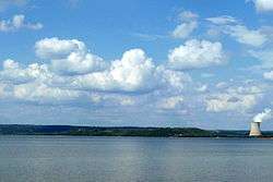
The Dardanelle Lock & Dam, constructed in the 1960s as a part of the McClellan-Kerr Navigation System, led to the formation of Lake Dardanelle. It is a source of hydropower, and helps regulate river traffic on the Arkansas River. For 2013, over 8.9 million dollars were budgeted for its operations.[8]
Geography
Dardanelle is located at 35°13′21″N 93°9′37″W / 35.22250°N 93.16028°W (35.222539, -93.160408).[9]
According to the United States Census Bureau, the city has a total area of 3.1 square miles (8.0 km2), all land.
Demographics
| Historical population | |||
|---|---|---|---|
| Census | Pop. | %± | |
| 1860 | 299 | — | |
| 1870 | 926 | 209.7% | |
| 1880 | 748 | −19.2% | |
| 1890 | 1,456 | 94.7% | |
| 1900 | 1,602 | 10.0% | |
| 1910 | 1,757 | 9.7% | |
| 1920 | 1,835 | 4.4% | |
| 1930 | 1,832 | −0.2% | |
| 1940 | 1,807 | −1.4% | |
| 1950 | 1,772 | −1.9% | |
| 1960 | 2,098 | 18.4% | |
| 1970 | 3,297 | 57.1% | |
| 1980 | 3,621 | 9.8% | |
| 1990 | 3,722 | 2.8% | |
| 2000 | 4,228 | 13.6% | |
| 2010 | 4,745 | 12.2% | |
| Est. 2015 | 4,659 | [10] | −1.8% |
2014 Estimate[12] | |||
As of the census[13] of 2000, there were 4,228 people, 1,605 households, and 1,078 families residing in the city. The population density was 1,382.0 people per square mile (533.5/km²). There were 1,747 housing units at an average density of 571.0 per square mile (220.4/km²). The racial makeup of the city was 75.24% White, 4.64% Black or African American, 0.54% Native American, 0.43% Asian, 0.09% Pacific Islander, 16.65% from other races, and 2.41% from two or more races. 21.48% of the population were Hispanic or Latino of any race.
In the city the population was spread out with 25.4% under the age of 18, 9.9% from 18 to 24, 28.5% from 25 to 44, 19.7% from 45 to 64, and 16.5% who were 65 years of age or older. The median age was 35 years. For every 100 females there were 92.7 males. For every 100 females age 18 and over, there were 86.6 males.
The median income for a household in the city was $25,727, and the median income for a family was $30,457. Males had a median income of $21,138 versus $17,370 for females. The per capita income for the city was $14,583. About 14.9% of families and 19.6% of the population were below the poverty line, including 26.5% of those under age 18 and 14.0% of those age 65 or over.
According to 2010 Census results, the population of the area was approximately 4,745 people. From 2000 to 2010, the Dardanelle city population growth percentage was 12.2% (or from 4,228 people to 4,745 people). 28.7% of the Dardanelle city residents were under 18 years of age. Racial data for Dardanelle city include the breakdown percentages of 57.9% non-Latino White, 3.6% African American, 0.5% Asian and 36.1% Hispanic, with 1,346 of 1,745 Latino residents being of Mexican descent.
Also, there were 1,877 housing units in Dardanelle city, 89.5% of which were occupied housing units, with just over 50% of occupied units being those of homeowners. There were 1,680 households out of which 39.7% had children under the age of 18 living with them, 42.4% were married couples living together, 15.8% had a female householder with no husband present, and 33.6% were non-families. 29.2% of all households were made up of individuals and 27.6% had someone living alone who was 65 years of age or older. The average household size was 2.74 and the average family size was 3.33.[14]
Economy

Dardanelle's downtown area is currently under a drastic revitalization. After falling into decay for a number of years, Front Street on the River is once again a thriving place. Daly's Downtown (now Front Street Grill) and Savanah's have anchored this rejuvenation. The Bank of Dardanelle (now River Town Bank), which now has ten locations across the state, first opened on Front Street many years ago. The Dardanelle Post-Dispatch, the oldest weekly newspaper in the state, have their offices there. Millyn's and a number of other businesses can be found there, too. Beautiful views of the river, historic buildings, and a thriving restaurant scene makes Front Street one of the premier places to go in the Arkansas River Valley.
Other main commercial areas in the city include Union Street, Quay Street, and 2nd Street. A Wal-Mart Supercenter opened in October 2005, replacing the old Wal-Mart Express.
Dardanelle is well known for its local restaurants. Daly's Downtown (now Front Street Grill), and Savannah's can be found on Front Street. Catfish 'N was ranked by USA Today as one of the best restaurants in America. A plethora of Mexican restaurants, such as Tarasco's Mexican Restaurant, El Parian and Casa de Sol can be found, showcasing the city's vibrant Hispanic culture. The Port of Dardanelle is one of the busiest in Arkansas.
Arts and culture
Museums and other points of interest
.JPG)
A number of attractions can be found in Dardanelle or its surrounding area, including:
- The Yell County Courthouse (on the National Register of Historic Places)
- Dardanelle Rock
Sports
- The Lion's Den Golf Course
Parks and recreation
- Lake Dardanelle
- Mount Nebo and Mount Nebo State Park
- Holla Bend National Wildlife Refuge
- Dana Merritt Park
- Veterans' Memorial Riverfront Park
- Council Oaks Park and Historic Site
Education
Public education
Public elementary and secondary education is provided by Dardanelle School District that leads students to graduate at Dardanelle High School.[15]
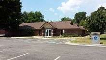
Public library
The Arkansas River Valley Regional Library system is based in Dardanelle, which consists of one central library, located at 501 North Front Street, and six branch libraries in other communities, which provide area residents with access to print books, publications and multimedia content.
Infrastructure
Transportation
The Dardanelle and Russellville Railroad, or "D&R" as it is known locally, is one of few remaining short-line railroads in the state. It connects Dardanelle with its larger neighbor on the north bank of the river.
Highways 7, 22, 27, and 28 can be found ending or going through Dardanelle. Dardanelle is halfway between the Buffalo River to the north and Hot Springs to the south on Scenic Byway 7.
Notable people
- Jim R. Caldwell, born in Dardanelle in 1936 and reared there through the eleventh grade; first Republican to serve in the Arkansas State Senate in the 20th century, 1969-1978; retired Church of Christ minister in Tulsa, Oklahoma
- Tom Cotton, Republican junior U.S. Senator from Arkansas
- John Daly, golfer, lived in Dardanelle as a child; he currently owns a home near Dardanelle and the Lion's Den Golf Course.
- Trevor Drown, Arkansas state representative since 2015 for Pope and Van Buren counties; former resident of Dardanelle
- James Lee Witt, former director of the Federal Emergency Management Agency.
See also
- True Grit (novel), setting for the novel is a farm in the Dardanelle area.
References
- ↑ "City of Dardanelle Arkansas". City of Dardanelle Arkansas. Retrieved September 12, 2012.
- ↑ "Find a County". National Association of Counties. Retrieved 2011-06-07.
- 1 2 Dardanelle Pontoon Bridge
- ↑ Treaty of Council Oaks
- ↑ "Dardanelle (Yell County)". The Encyclopedia of Arkansas History and Culture. Retrieved 31 October 2013.
- ↑ "Brearley Cemetery Historic Section, Dardanelle, Yell County". Arkansas Historic Preservation Program. Retrieved 5 November 2013.
- ↑ Dardanelle, AR Population and Races
- ↑ "Dardanelle Lock & Dam, AR Fact Sheet" (PDF). U.S. Army Corps of Engineers. 5 February 2012. Retrieved 5 November 2013.
- ↑ "US Gazetteer files: 2010, 2000, and 1990". United States Census Bureau. 2011-02-12. Retrieved 2011-04-23.
- ↑ "Annual Estimates of the Resident Population for Incorporated Places: April 1, 2010 to July 1, 2015". Retrieved July 2, 2016.
- ↑ "Census of Population and Housing". Census.gov. Retrieved June 4, 2015.
- ↑ "Annual Estimates of the Resident Population for Incorporated Places: April 1, 2010 to July 1, 2014". Retrieved June 4, 2015.
- ↑ "American FactFinder". United States Census Bureau. Retrieved 2008-01-31.
- ↑ "Profile of General Population and Housing Characteristics: 2010 Demographic Profile Data". American Factfinder. United States Census Bureau. 5 February 2012. Retrieved 5 November 2013.
- ↑ "Dardanelle School District". Dardanelle School District. Retrieved September 12, 2012.
External links
| Wikimedia Commons has media related to Dardanelle, Arkansas. |
- Dardanelle Chamber of Commerce
- City of Dardanelle Arkansas Portal style website, Government, Business, Library, Recreation and more
- City-Data.com Comprehensive Statistical Data and more about Dardanelle
Municipalities and communities of Yell County, Arkansas, United States | ||
|---|---|---|
| Cities | 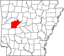 | |
| Town | ||
| Unincorporated communities | ||