Newton County, Arkansas
| Newton County, Arkansas | |
|---|---|
 | |
 Location in the U.S. state of Arkansas | |
 Arkansas's location in the U.S. | |
| Founded | December 14, 1842 |
| Named for | Thomas Willoughby Newton |
| Seat | Jasper |
| Largest city | Jasper |
| Area | |
| • Total | 823 sq mi (2,132 km2) |
| • Land | 821 sq mi (2,126 km2) |
| • Water | 2.3 sq mi (6 km2), 0.3% |
| Population (est.) | |
| • (2015) | 7,913 |
| • Density | 10/sq mi (4/km²) |
| Congressional districts | 3rd, 4th |
| Time zone | Central: UTC-6/-5 |
Newton County is a county located in the U.S. state of Arkansas. As of the 2010 census, the population was 8,330.[1] The county seat is Jasper.[2] Newton County is Arkansas's 46th county, formed on December 14, 1842, and named for Thomas W. Newton, an Arkansas Congressman. It is an alcohol prohibition or dry county.
Newton County is part of the Harrison , AR Micropolitan Statistical Area.
History
Newton County residents were very divided during the Civil War, serving in both the Confederate and Union armies. John Cecil, who had earlier served as Newton County's sheriff, served as a Confederate Captain. Jasper blacksmith James R. Vanderpool (ca. 1832-1880) served as Captain of Union Company C, 1st Regiment Arkansas Infantry Volunteers, while farmer and teacher John McCoy (1820–1903) served as Captain of Union Company F, 1st Regiment Arkansas Infantry Volunteers. Many Newton County citizens served under each of these men, as well as in other units. As an example of how the war divided families, Confederate Captain Cecil's brother, Sam, served as a sergeant in Union Company D, 2nd Regiment Arkansas Cavalry Volunteers. Violence took a severe toll on the civilian population, and at one point, Captains McCoy and Vanderpool escorted 20 wagons of Unionist families from Newton County to Missouri to seek refuge.[3]
Geography
According to the U.S. Census Bureau, the county has a total area of 823 square miles (2,130 km2), of which 821 square miles (2,130 km2) is land and 2.3 square miles (6.0 km2) (0.3%) is water.[4]
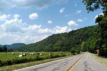
Newton County lies almost entirely within the rugged Boston Mountain range of the Ozark Mountains where elevations exceed 2,500 feet (760 m). The Buffalo National River, a popular destination for canoeing and recreation, runs through the county from west to east. Highway 7, which traverses the county from north to south, has been rated as one of the most scenic drives in the region.
Major highways
 U.S. Highway 65
 Arkansas Highway 7
 Arkansas Highway 16
 Arkansas Highway 21
 Arkansas Highway 43
 Arkansas Highway 74
 Arkansas Highway 123
Adjacent counties
- Boone County (north)
- Searcy County (east)
- Pope County (southeast)
- Johnson County (south)
- Madison County (west)
- Carroll County (northwest)
National protected areas
Demographics
| Historical population | |||
|---|---|---|---|
| Census | Pop. | %± | |
| 1850 | 1,758 | — | |
| 1860 | 3,393 | 93.0% | |
| 1870 | 4,374 | 28.9% | |
| 1880 | 6,120 | 39.9% | |
| 1890 | 9,950 | 62.6% | |
| 1900 | 12,538 | 26.0% | |
| 1910 | 10,612 | −15.4% | |
| 1920 | 11,199 | 5.5% | |
| 1930 | 10,564 | −5.7% | |
| 1940 | 10,881 | 3.0% | |
| 1950 | 8,685 | −20.2% | |
| 1960 | 5,963 | −31.3% | |
| 1970 | 5,844 | −2.0% | |
| 1980 | 7,756 | 32.7% | |
| 1990 | 7,666 | −1.2% | |
| 2000 | 8,608 | 12.3% | |
| 2010 | 8,330 | −3.2% | |
| Est. 2015 | 7,913 | [5] | −5.0% |
| U.S. Decennial Census[6] 1790–1960[7] 1900–1990[8] 1990–2000[9] 2010–2015[1] | |||
As of the 2000 United States Census,[11] there were 8,608 people, 3,500 households, and 2,495 families residing in the county. The population density was 4/km² (10/sq mi), one of the most sparse among county populations in Arkansas. There were 4,316 housing units at an average density of 5 per square mile (2/km²). The racial makeup of the county was 99.29% White, 0.00% Black or African American, 0.56% Native American, 0.06% Asian, 0.00% Pacific Islander, 0.09% from other races, and 0.00% from two or more races. 0.00% of the population were Hispanic or Latino of any race.
There were 3,500 households out of which 32.20% had children under the age of 18 living with them, 60.00% were married couples living together, 7.70% had a female householder with no husband present, and 28.70% were non-families. 26.00% of all households were made up of individuals and 10.90% had someone living alone who was 65 years of age or older. The average household size was 2.44 and the average family size was 2.94.
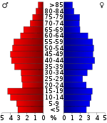
In the county the population was spread out with 24.90% under the age of 18, 7.60% from 18 to 24, 25.00% from 25 to 44, 27.60% from 45 to 64, and 14.80% who were 65 years of age or older. The median age was 40 years. For every 100 females there were 102.30 males. For every 100 females age 18 and over, there were 98.60 males.
The median income for a household in the county was $24,756, and the median income for a family was $30,134. Males had a median income of $22,406 versus $17,654 for females. The per capita income for the county was $13,788. About 15.70% of families and 20.40% of the population were below the poverty line, including 27.80% of those under age 18 and 16.90% of those age 65 or over.
Native residents of Newton County were interviewed in 1970 for research being done by a doctoral student at the University of Arkansas in Fayetteville. A Ph.D. degree was awarded to Bethany K. Dumas in May 1971 after she completed "A Study of the Dialect of Newton County, Arkansas." Results are discussed in two of her published articles/chapters: “The Morphology of Newton County, Arkansas: An Exercise in Studying Ozark Dialect,” Mid–South Folklore 3 (1975), 115–125, and “Southern Mountain English” Chapter 5 of The Workings of Language, ed. R. S. Wheeler, Westport, CT, and London: Praeger, 1999, 67-79.
Attractions
24 Hours of Horseshoe Hell (24HHH) is an annual rock-climbing competition held at Horseshoe Canyon Ranch in Newton County.[12] Using difficulty ratings based on the Yosemite Decimal System, teams of two attempt to climb as many routes as possible in 24 hours. The sandstone walls of the canyon has over 411 established routes. The event was first held in 2006, and was rated by Climbing magazine as one of the most difficult endurance events in the nation.[13][14]
Communities
City
- Jasper (county seat)
Town
Unincorporated communities
Townships
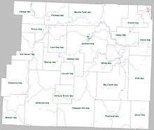
Townships in Arkansas are the divisions of a county. Each township includes unincorporated areas; some may have incorporated cities or towns within part of their boundaries. Arkansas townships have limited purposes in modern times. However, the United States Census does list Arkansas population based on townships (sometimes referred to as "county subdivisions" or "minor civil divisions"). Townships are also of value for historical purposes in terms of genealogical research. Each town or city is within one or more townships in an Arkansas county based on census maps and publications. The townships of Newton County are listed below; listed in parentheses are the cities, towns, and/or census-designated places that are fully or partially inside the township. [15][16]
| Township | FIPS code | ANSI code (GNIS ID) |
Population center(s) |
Pop. (2010) |
Pop. density (/mi²) |
Pop. density (/km²) |
Total area (mi²) |
Total area (km²) |
Land area (mi²) |
Land area (km²) |
Water area (mi²) |
Water area (km²) |
Geographic coordinates |
|---|---|---|---|---|---|---|---|---|---|---|---|---|---|
| Big Creek | 05-90270 | 00069672 | 244 | 4.97 | 1.92 | 49.135 | 127.3 | 49.084 | 127.1 | 0.051 | 0.1321 | 35°52′12″N 93°04′44″W / 35.870031°N 93.078980°W | |
| Boston | 05-90417 | 00069673 | 65 | 2.03 | 0.79 | 31.965 | 82.79 | 31.947 | 82.74 | 0.018 | 0.04662 | 35°48′08″N 93°29′11″W / 35.802293°N 93.486503°W | |
| Grove | 05-91545 | 00069674 | Western Grove | 907 | 26.04 | 10.06 | 34.979 | 90.60 | 34.825 | 90.20 | 0.154 | 0.3989 | 36°02′16″N 92°58′12″W / 36.037719°N 92.970012°W |
| Hasty | 05-91641 | 00069675 | 268 | 14.09 | 5.44 | 19.123 | 49.53 | 19.014 | 49.25 | 0.109 | 0.2823 | 35°59′59″N 93°02′12″W / 35.999647°N 93.036620°W | |
| Hickory Grove | 05-91695 | 00069676 | 129 | 7.60 | 2.93 | 16.989 | 44.00 | 16.980 | 43.98 | 0.009 | 0.02331 | 35°50′24″N 93°16′54″W / 35.839875°N 93.281762°W | |
| Hudson | 05-91788 | 00069677 | 327 | 17.33 | 6.69 | 18.951 | 49.08 | 18.873 | 48.88 | 0.078 | 0.2020 | 35°56′10″N 93°14′33″W / 35.936140°N 93.242629°W | |
| Jackson | 05-91872 | 00069678 | Jasper | 1,620 | 27.19 | 10.50 | 59.933 | 155.2 | 59.573 | 154.3 | 0.360 | 0.9324 | 36°00′10″N 93°10′50″W / 36.002703°N 93.180608°W |
| Jefferson | 05-91941 | 00069679 | 284 | 3.54 | 1.37 | 80.396 | 208.2 | 80.312 | 208.0 | 0.084 | 0.2176 | 35°49′04″N 93°22′46″W / 35.817879°N 93.379476°W | |
| Jones | 05-91995 | 00069680 | 29 | 1.19 | 0.46 | 24.429 | 63.27 | 24.410 | 63.22 | 0.019 | 0.04921 | 35°44′41″N 92°59′42″W / 35.744590°N 92.994921°W | |
| Kentucky | 05-92031 | 00069681 | 60 | 1.49 | 0.58 | 40.325 | 104.4 | 40.222 | 104.2 | 0.103 | 0.2668 | 35°53′06″N 93°26′34″W / 35.885138°N 93.442773°W | |
| Lincoln | 05-92211 | 00069682 | 248 | 17.32 | 6.69 | 14.329 | 37.11 | 14.319 | 37.09 | 0.010 | 0.02590 | 35°53′10″N 93°16′14″W / 35.886049°N 93.270498°W | |
| Low Gap | 05-92295 | 00069683 | 268 | 11.45 | 4.42 | 23.487 | 60.83 | 23.397 | 60.60 | 0.090 | 0.2331 | 36°01′57″N 93°18′32″W / 36.032597°N 93.308932°W | |
| Marble Falls | 05-92373 | 02406958 | 932 | 15.86 | 6.12 | 59.044 | 152.9 | 58.751 | 152.2 | 0.293 | 0.7589 | 36°04′43″N 93°09′07″W / 36.078548°N 93.151902°W | |
| Murray | 05-92655 | 00069685 | 172 | 10.30 | 3.98 | 16.732 | 43.34 | 16.696 | 43.24 | 0.036 | 0.09324 | 35°56′42″N 93°19′38″W / 35.944909°N 93.327241°W | |
| Osage | 05-92772 | 00069686 | 238 | 7.62 | 2.94 | 31.285 | 81.03 | 31.221 | 80.86 | 0.064 | 0.1658 | 36°05′13″N 93°25′04″W / 36.087078°N 93.417719°W | |
| Pleasant Hill | 05-92919 | 00069687 | 386 | 5.27 | 2.04 | 73.285 | 189.8 | 73.176 | 189.5 | 0.109 | 0.2823 | 35°47′47″N 93°13′41″W / 35.796427°N 93.228082°W | |
| Plumlee | 05-92928 | 00069688 | 223 | 8.71 | 3.36 | 25.767 | 66.74 | 25.608 | 66.32 | 0.159 | 0.4118 | 36°04′45″N 93°18′20″W / 36.079286°N 93.305643°W | |
| Polk | 05-92949 | 00069689 | 224 | 4.64 | 1.79 | 48.347 | 125.2 | 48.295 | 125.1 | 0.052 | 0.1347 | 35°53′39″N 92°59′27″W / 35.894152°N 92.990789°W | |
| Ponca | 05-92958 | 00069690 | 158 | 8.70 | 3.36 | 18.253 | 47.28 | 18.155 | 47.02 | 0.098 | 0.2538 | 36°01′30″N 93°22′51″W / 36.025099°N 93.380959°W | |
| Prairie | 05-93006 | 00069691 | 252 | 14.77 | 5.70 | 17.077 | 44.23 | 17.064 | 44.20 | 0.013 | 0.03367 | 36°04′01″N 93°01′26″W / 36.066934°N 93.023884°W | |
| Richland | 05-93150 | 00069692 | 281 | 5.81 | 2.24 | 48.386 | 125.3 | 48.335 | 125.2 | 0.051 | 0.1321 | 35°45′24″N 93°06′29″W / 35.756678°N 93.107967°W | |
| Van Buren | 05-93774 | 00069694 | 185 | 5.32 | 2.05 | 34.885 | 90.35 | 34.764 | 90.04 | 0.121 | 0.3134 | 35°57′07″N 93°25′21″W / 35.952003°N 93.422449°W | |
| White | 05-93990 | 00069696 | 830 | 23.14 | 8.93 | 36.086 | 93.46 | 35.876 | 92.92 | 0.210 | 0.5439 | 35°56′50″N 93°06′25″W / 35.947124°N 93.106975°W | |
| Source: "Census 2010 U.S. Gazetteer Files: County Subdivisions in Arkansas". U.S. Census Bureau, Geography Division.
Source: "Census 2010 U.S. Gazetteer Files". U.S. Census Bureau, Geography Division. | |||||||||||||
See also
References
- 1 2 "State & County QuickFacts". United States Census Bureau. Retrieved May 23, 2014.
- ↑ "Find a County". National Association of Counties. Retrieved 2011-06-07.
- ↑ Lackey, Walter F. History of Newton County, Arkansas, Point Lookout, MO: S of O Press, 1950.
- ↑ "2010 Census Gazetteer Files". United States Census Bureau. August 22, 2012. Retrieved August 27, 2015.
- ↑ "County Totals Dataset: Population, Population Change and Estimated Components of Population Change: April 1, 2010 to July 1, 2015". Retrieved July 2, 2016.
- ↑ "U.S. Decennial Census". United States Census Bureau. Retrieved August 27, 2015.
- ↑ "Historical Census Browser". University of Virginia Library. Retrieved August 27, 2015.
- ↑ Forstall, Richard L., ed. (March 27, 1995). "Population of Counties by Decennial Census: 1900 to 1990". United States Census Bureau. Retrieved August 27, 2015.
- ↑ "Census 2000 PHC-T-4. Ranking Tables for Counties: 1990 and 2000" (PDF). United States Census Bureau. April 2, 2001. Retrieved August 27, 2015.
- ↑ Based on 2000 census data
- ↑ "American FactFinder". United States Census Bureau. Retrieved 2011-05-14.
- ↑ "Rock Climbing." www.horseshoecanyonduderanch.com. Retrieved September 8, 2014.
- ↑ Robinson, Bob. "Rock around the clock: Crag climbers put themselves through 24 Hours of Horseshoe Hell." Arkansas Democrat-Gazette, October 21, 2013. 6E.
- ↑ Hewitt, Andrew. "UPDATED: Rave Reviews and Sleepless Sending at 24 Hours of Horseshoe Hell." www.rockandice.com, October 10, 2013. Retrieved September 8, 2014.
- ↑ 2011 Boundary and Annexation Survey (BAS): Newton County, AR (PDF) (Map). U. S. Census Bureau. Retrieved 2011-06-28.
- ↑ "Arkansas: 2010 Census Block Maps - County Subdivision". United States Census Bureau. Retrieved June 28, 2014.
External links
- Map of Newtown County from the U. S. Census Bureau
- Map of Newton County from the Encyclopedia of Arkansas
- Newton County entry in the Encyclopedia of Arkansas
- Jasper/Newton County Chamber of Commerce
- Newton County Historical Society
- Newton County Scrap book
- 24 Hours of Horseshoe Hell
- Newton County Sheriff
 |
Carroll County | Boone County | | |
| Madison County | |
Searcy County | ||
| ||||
| | ||||
| Johnson County | Pope County |
Municipalities and communities of Newton County, Arkansas, United States | ||
|---|---|---|
| City | | |
| Town | ||
| Townships |
| |
| Unincorporated communities | ||
Coordinates: 35°56′08″N 93°13′19″W / 35.93556°N 93.22194°W