Arlington, Vermont
| Arlington, Vermont | |
|---|---|
| Town | |
|
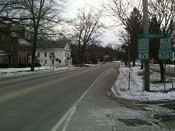
Downtown Arlington | |
 Arlington, Vermont | |
 Arlington, Vermont Location in the United States | |
| Coordinates: 43°4′29″N 73°9′50″W / 43.07472°N 73.16389°WCoordinates: 43°4′29″N 73°9′50″W / 43.07472°N 73.16389°W | |
| Country | United States |
| State | Vermont |
| County | Bennington |
| Area | |
| • Total | 42.4 sq mi (109.9 km2) |
| • Land | 42.2 sq mi (109.4 km2) |
| • Water | 0.2 sq mi (0.5 km2) |
| Elevation | 581 ft (177 m) |
| Population (2010) | |
| • Total | 2,317 |
| • Density | 55/sq mi (21.2/km2) |
| Time zone | Eastern (EST) (UTC-5) |
| • Summer (DST) | EDT (UTC-4) |
| ZIP code | 05250 |
| Area code(s) | 802 |
| FIPS code | 50-01450[1] |
| GNIS feature ID | 1462027[2] |
| Website |
www |
Arlington is a town in Bennington County, Vermont, United States. The population was 2,317 at the 2010 census.[3]
History
The town of Arlington was chartered July 28, 1761, by New Hampshire Governor Benning Wentworth, as part of the New Hampshire Grants. In 1777, Arlington became the first capital of the Vermont Republic.
Among the first settlers in Arlington were Captain Jehiel Hawley and his family, who had settled there by 1764. They were Anglicans and had fled Roxbury, Connecticut, because of the oppressive requirements of the established Congregational church. At a Proprietor's meeting in 1764, the town voted to give 50 acres (20 hectares) of land to any man who would set up a gristmill in what is now East Arlington. This offer was accepted by Remember Baker (first cousin of Ethan Allen), who built a grist and sawmill.
In the years leading up to the American Revolution, both New York and New Hampshire laid claim to lands comprising current-day Vermont. The Province of New York began to grant land in 1765, lagging New Hampshire by four years. Arlington was, for the most part, settled by Anglicans from Roxbury, Newtown, and Milford, Connecticut, with ownership rights derived from the New Hampshire Grants.
When settlers with New York grants arrived, conflicts ensued. Among other things, the residents of Arlington relied on the militancy of Ethan Allen to discourage those touting New York grants. Ethan Allen and his group were known by their friends as the Green Mountain Boys. They were relatively effective in promoting the cause of New Hampshire grantees, although legal ownership was not settled monetarily for many years.
Several members of the Green Mountain Boys lived, in Arlington, before the American Revolution, including Thomas Chittenden, Seth Warner and Remember Baker, who was the first town clerk. Gideon Hard, a congressman, from New York, was born in Arlington.[4] During the American Revolutionary War, the Patriot soldiers, of the Green Mountain Boys, rallied, against Loyalist opposition, in the town. British Loyalist citizens, in Arlington, united under the leadership of Dr. Samuel Adams, organized an independent, military unit, Adams' Rangers, to support the British war effort, in the region. In 1777, Adams' men saw action, fighting for British General John Burgoyne, at the Battle of Saratoga, in the Province of New York and were soundly defeated.
Geography
Arlington lies in the Valley of Vermont between the Taconic Range to the west and the Green Mountains to the east, with most of Arlington's land mass lying in the Taconic Range. Five prominent peaks are located within the town: Grass Mountain, Spruce Peak, The Ball (also locally referred to as West Mountain), Red Mountain, and Big Spruce Mountain. The highest peak is Grass Mountain at elevation 3,109 ft (948 m).
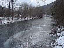
According to the United States Census Bureau, the town has a total area of 42.4 square miles (109.9 km2), of which 42.2 square miles (109.4 km2) is land and 0.19 square miles (0.5 km2), or 0.45%, is water.[3] The Battenkill River, famous for trout fishing, flows through the center of town.
| Climate data for Arlington, Vermont | |||||||||||||
|---|---|---|---|---|---|---|---|---|---|---|---|---|---|
| Month | Jan | Feb | Mar | Apr | May | Jun | Jul | Aug | Sep | Oct | Nov | Dec | Year |
| Average high °C | −1.9 | 0.9 | 4.9 | 12.4 | 18.8 | 24.1 | 25.8 | 25.1 | 20.9 | 14.1 | 7.7 | 1.3 | 12.9 |
| Daily mean °C | −7.2 | −5.3 | −1.0 | 5.9 | 11.9 | 16.9 | 19.2 | 18.3 | 13.8 | 7.7 | 2.7 | −3.4 | 6.7 |
| Average low °C | −12.5 | −11.6 | −6.9 | −0.6 | 5.5 | 9.8 | 12.5 | 11.7 | 6.8 | 1.3 | −2.3 | −8.2 | 0.5 |
| Average precipitation mm | 86.4 | 71.1 | 91.4 | 88.9 | 109.2 | 119.4 | 116.8 | 111.8 | 96.5 | 109.2 | 101.6 | 101.6 | 1,201.4 |
| Average snowfall cm | 49.8 | 42.2 | 33.0 | 10.4 | — | — | — | — | — | 1.5 | 10.2 | 43.7 | 190.8 |
| Average high °F | 28.6 | 33.6 | 40.8 | 54.3 | 65.8 | 75.4 | 78.4 | 77.2 | 69.6 | 57.4 | 45.9 | 34.3 | 55.2 |
| Daily mean °F | 19 | 22.5 | 30.2 | 42.6 | 53.4 | 62.4 | 66.6 | 64.9 | 56.8 | 45.9 | 36.9 | 25.9 | 44.1 |
| Average low °F | 9.5 | 11.1 | 19.6 | 30.9 | 41.9 | 49.6 | 54.5 | 53.1 | 44.2 | 34.3 | 27.9 | 17.2 | 32.9 |
| Average precipitation inches | 3.402 | 2.799 | 3.598 | 3.5 | 4.299 | 4.701 | 4.598 | 4.402 | 3.799 | 4.299 | 4 | 4 | 47.299 |
| Average snowfall inches | 19.61 | 16.61 | 12.99 | 4.09 | — | — | — | — | — | 0.59 | 4.02 | 17.2 | 75.12 |
| Average precipitation days | 14.7 | 11.2 | 13.5 | 12.6 | 14.3 | 13.3 | 12.6 | 11.8 | 11.0 | 12.3 | 12.9 | 14.7 | 154.9 |
| Average snowy days | 10.6 | 8.7 | 7.3 | 2.3 | — | — | — | — | — | 0.4 | 3.0 | 9.0 | 41.3 |
| Source: [5] | |||||||||||||
Demographics
| Historical population | |||
|---|---|---|---|
| Census | Pop. | %± | |
| 1790 | 991 | — | |
| 1800 | 1,597 | 61.2% | |
| 1810 | 1,463 | −8.4% | |
| 1820 | 1,354 | −7.5% | |
| 1830 | 1,207 | −10.9% | |
| 1840 | 1,035 | −14.3% | |
| 1850 | 1,084 | 4.7% | |
| 1860 | 1,146 | 5.7% | |
| 1870 | 1,636 | 42.8% | |
| 1880 | 1,532 | −6.4% | |
| 1890 | 1,352 | −11.7% | |
| 1900 | 1,193 | −11.8% | |
| 1910 | 1,307 | 9.6% | |
| 1920 | 1,370 | 4.8% | |
| 1930 | 1,441 | 5.2% | |
| 1940 | 1,418 | −1.6% | |
| 1950 | 1,463 | 3.2% | |
| 1960 | 1,605 | 9.7% | |
| 1970 | 1,934 | 20.5% | |
| 1980 | 2,184 | 12.9% | |
| 1990 | 2,299 | 5.3% | |
| 2000 | 2,397 | 4.3% | |
| 2010 | 2,317 | −3.3% | |
| Est. 2014 | 2,277 | [6] | −1.7% |
| U.S. Decennial Census[7] | |||
As of the census[1] of 2000, there were 2,397 people, 1,009 households, and 676 families residing in the town. The population density was 56.5 people per square mile (21.8/km2). There were 1,200 housing units at an average density of 28.3 per square mile (10.9/km2). The racial makeup of the town was 98.08% White, 0.25% Black, 0.08% Native American, 0.42% Asian, 0.08% Pacific Islander, 0.21% from other races, and 0.88% from two or more races. Hispanic of any race were 0.46% of the population.
There were 1,009 households out of which 28.5% had children under the age of 18 living with them, 56.3% were couples living together and joined in either marriage or civil union, 8.1% had a female householder with no husband present, and 33.0% were non-families. 27.9% of all households were made up of individuals and 12.8% had someone living alone who was 65 years of age or older. The average household size was 2.38 and the average family size was 2.90.
In the town the population was spread out with 23.0% under the age of 18, 6.0% from 18 to 24, 26.2% from 25 to 44, 28.3% from 45 to 64, and 16.5% who were 65 years of age or older. The median age was 42 years. For every 100 females there were 93.6 males. For every 100 women age 18 and over, there were 88.1 men.
The median income for a household in the town was $40,590, and the median income for a family was $49,412. Males had a median income of $31,250 versus $22,199 for females. The per capita income for the town was $23,277. About 6.4% of families and 7.2% of the population were below the poverty line, including 9.3% of those under age 18 and 7.2% of those age 65 or over.
Education
Schools in Arlington include Arlington Memorial School, a high school with some 250 students.
Economy
One of the largest employers for residents of Arlington is the Orvis company in neighboring Sunderland.

Mack Moulding is the largest employer in Arlington by far. Orvis has its offices in Sunderland and a retail outlet in Manchester Center.
Notable people
- Samuel Adams, early Vermont settler and American Revolutionary War, British Loyalist, who formed the British, military unit, Adams' Rangers
- Remember Baker, early Vermont settler and Green Mountain Boy
- Holly Bakke, Former New Jersey Commissioner of Banking and Insurance
- Burnham band, went on tour with Justin Bieber and Jasmine V
- Thomas Chittenden, first governor of Vermont and first and third governor of the Vermont Republic
- Chick Evans, baseball player
- Dorothy Canfield Fisher, author and educator; credited with bringing the Montessori method to the US; lived and died in Arlington
- Michael J. Fox lived in Arlington, also, was married in Arlington
- Gideon Hard, former U.S. Congressman
- Norman Rockwell, painter and illustrator (Willie Gillis, The Problem We All Live With, Four Freedoms); lived in Arlington
- Carl Ruggles, composer and painter[8]
- Seth Warner, early Vermont settler and Green Mountain Boy
See also
References
- 1 2 "American FactFinder". United States Census Bureau. Archived from the original on 2013-09-11. Retrieved 2008-01-31.
- ↑ "US Board on Geographic Names". United States Geological Survey. 2007-10-25. Retrieved 2008-01-31.
- 1 2 "Geographic Identifiers: 2010 Demographic Profile Data (G001): Arlington town, Bennington County, Vermont". U.S. Census Bureau, American Factfinder. Retrieved April 25, 2014.
- ↑ Who Was Who in America, Historical Volume. Chicago: Marquis Who's Who. 1963.
- ↑ "www.weatherbase.com". Retrieved May 15, 2015.
- ↑ "Annual Estimates of the Resident Population for Incorporated Places: April 1, 2010 to July 1, 2014". Retrieved June 4, 2015.
- ↑ "U.S. Decennial Census". United States Census Bureau. Archived from the original on May 11, 2015. Retrieved May 16, 2015.
- ↑ Charles Ives Remembered: An Oral History
External links
Municipalities and communities of Bennington County, Vermont, United States | ||
|---|---|---|
| Towns |  | |
| Villages | ||
| CDPs | ||
| Footnotes | ‡ Disincorporated | |