Arraial do Cabo
| Arraial do Cabo | |
|---|---|
| Municipality | |
 | |
| Nickname(s): The Diving Capital [1] | |
 Arraial do Cabo | |
| Coordinates: 22°57′57″S 42°01′40″W / 22.96583°S 42.02778°WCoordinates: 22°57′57″S 42°01′40″W / 22.96583°S 42.02778°W | |
| Country | Brazil |
| State | Rio de Janeiro |
| First Settled | 1503 [2] |
| Elevated to District | January 28, 1924 [3] |
| Emancipated from Cabo Frio | May 13, 1985 [4] |
| Founded by | Amerigo Vespucci [4] |
| Government[5] | |
| • Mayor | Wanderson Cardoso de Brito (PMDB) |
| Area[3] | |
| • Total | 160.286 km2 (61.887 sq mi) |
| Brazilian Institute of Geography and Statistics | |
| Population (2010)[3] | |
| • Total | 27,715 |
| • Estimate (2013) | 28,627 |
| • Density | 170/km2 (450/sq mi) |
| Brazilian Institute of Geography and Statistics | |
| Demonym(s) | cabista |
| Time zone | BRT (UTC-3) |
| • Summer (DST) | BRST (UTC-2) |
| Website |
www |
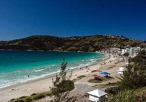
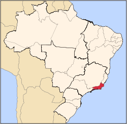
Arraial do Cabo is a municipality located in the Brazilian state of Rio de Janeiro. Its population was 27,715 as of 2010 census and its total area is 160 square kilometres (62 sq mi). [3]
It was founded in 1503 by the conqueror Amerigo Vespucci. In 1960 a documentary film was made directed by Mário Carneiro and Paulo Cesar Saraceni about the local fishing industry.[6]
Its geography made Arraial do Cabo an important and dangerous point in the age of sail. Since the Portuguese Navy arrival (1503) until nineteenth century many shipwrecks occurred. Due to this fact (and other biological factors) Arraial do Cabo is well known as the "Dive Capital".
The municipality operates the Ilha do Cabo Frio Biological Reserve, a fully protected conservation unit on an Atlantic island in the south east of the municipality.[7] It contains the 56,769 hectares (140,280 acres) Arraial do Cabo Marine Extractive Reserve, created in 1997.[8]
Climate
| Climate data for Arraial do Cabo, Rio de Janeiro, Brazil | |||||||||||||
|---|---|---|---|---|---|---|---|---|---|---|---|---|---|
| Month | Jan | Feb | Mar | Apr | May | Jun | Jul | Aug | Sep | Oct | Nov | Dec | Year |
| Average high °C (°F) | 34.2 (93.6) |
35.4 (95.7) |
30.1 (86.2) |
28.7 (83.7) |
27.2 (81) |
26.1 (79) |
25.4 (77.7) |
25.6 (78.1) |
27.1 (80.8) |
27.8 (82) |
29.5 (85.1) |
34.7 (94.5) |
29.32 (84.78) |
| Daily mean °C (°F) | 28.5 (83.3) |
29.1 (84.4) |
27.9 (82.2) |
26.5 (79.7) |
24.5 (76.1) |
22.7 (72.9) |
21 (70) |
21.4 (70.5) |
22.2 (72) |
25.2 (77.4) |
27.6 (81.7) |
28.3 (82.9) |
25.41 (77.76) |
| Average low °C (°F) | 22.9 (73.2) |
23.1 (73.6) |
22.8 (73) |
21.5 (70.7) |
20 (68) |
18.2 (64.8) |
17.6 (63.7) |
18.2 (64.8) |
19 (66) |
19.7 (67.5) |
20.7 (69.3) |
21.8 (71.2) |
20.46 (68.82) |
| Average precipitation mm (inches) | 78.2 (3.079) |
44.2 (1.74) |
52.8 (2.079) |
78.3 (3.083) |
69.1 (2.72) |
43.9 (1.728) |
44.7 (1.76) |
36.1 (1.421) |
61 (2.4) |
80.7 (3.177) |
81 (3.19) |
101.1 (3.98) |
771.1 (30.357) |
| Average relative humidity (%) | 82 | 82 | 82 | 80 | 81 | 81 | 80 | 81 | 81 | 82 | 82 | 82 | 81.3 |
| Source: climate-charts.com[9] | |||||||||||||
References
| Wikivoyage has a travel guide for Arraial do Cabo. |
- ↑ "Arraial do Cabo City Hall Website (in Portuguese)". Retrieved November 20, 2013.
- ↑ "Cabo Frio City history - part one(in Portuguese)" (PDF). Retrieved November 20, 2013.
- 1 2 3 4 "Brazilian Institute of Geography and Statistics Website". Retrieved November 20, 2013.
- 1 2 "City history at City Hall website (in Portuguese)". Retrieved November 20, 2013.
- ↑ "Mayor's page at City Hall website (in Portuguese)". Retrieved November 20, 2013.
- ↑ Arraial do Cabo, film by Mário Carneiro and Paulo Cesar Saraceni on YouTube
- ↑ Unidades de Conservação da Região dos Lagos (PDF) (in Portuguese), Petrobras, retrieved 2016-04-26
- ↑ RESEX Marinha do Arraial do Cabo (in Portuguese), ISA: Instituto Socioambiental, retrieved 2016-09-13
- ↑ "climate-charts.com". Retrieved December 28, 2012.
Capital: Rio de Janeiro | |||||||||||||||||||
| Mesoregion Baixadas |
|  | |||||||||||||||||
| Mesoregion Centro Fluminense |
| ||||||||||||||||||
| Mesoregion Metropolitana do Rio de Janeiro |
| ||||||||||||||||||
| Mesoregion Noroeste Fluminense |
| ||||||||||||||||||
| Mesoregion Norte Fluminense |
| ||||||||||||||||||
| Mesoregion Sul Fluminense |
| ||||||||||||||||||